This article needs additional citations for verification .(November 2016) |
A block is an administrative division of some South Asian countries.
This article needs additional citations for verification .(November 2016) |
A block is an administrative division of some South Asian countries.
In Bhutan, a block is called a gewog. It is essentially for oil a group of villages. Gewogs are official administrative units of Bhutan. The country is composed of 205 gewogs.
Each gewog is headed by a gup or headman.
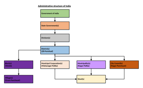
A block is a district sub-division for the purpose of rural development department and Panchayati Raj institutes. Cities have similar arrangements under the Urban Development department. Tehsils (also called taluks) are common across urban and rural areas for the administration of land and revenue department to keep track of land ownership and levy the land tax.
For planning purpose, a district is divided into four levels:
A tehsil may consist of one or more blocks. Blocks are usually planning and development units of a district in addition to tehsils. A block represents a compact area for which effective plans are prepared and implemented through gram panchayats.
For example, Muzaffarnagar district of Uttar Pradesh has nine blocks: Muzaffarnagar, Budhana, Baghra, Shahpur, Purquazi, Charthawal, Morna, Jansath, and Khatauli. [1]
The block development officer is the official in charge of a block. The officer monitors the implementation of all programmes relating to planning and development of the blocks. Coordination of development and implementation of plans in all blocks of a district is provided by a chief development officer (CDO). The BDO's office is the main operational wing of the government for the development administration as well as regulatory administration.
Sultanpur district is a district in the Awadh region of the Indian state of Uttar Pradesh. This district is a part of Ayodhya division of the state. The administrative headquarters of the district is Sultanpur city. The total area of Sultanpur district is 2672.89 Sq. km.

Mahoba district is a district of the Indian state of Uttar Pradesh. Headquartered in the city of Mahoba, the district had a population of a population of 875,958 as of the 2011 Indian census and occupies 2884 km2 within the Chitrakoot division of Uttar Pradesh. As of 2011 it was the least populous district of Uttar Pradesh. Mahoba District is also known as Alha-Udal Nagari.

Meerut district, is one of the districts of Uttar Pradesh state of India, with the city of Meerut as the district headquarters. Meerut district is also a part of the Meerut division. The administrative head of district of Meerut is a District Magistrate while the administrative head of Meerut Division is Divisional Commissioner, an IAS officer.
The administrative divisions of India are subnational administrative units of India; they are composed of a nested hierarchy of administrative divisions.
Panchayat samiti or block panchayat is a rural local government (panchayat) body at the intermediate tehsil (taluka/mandal) or block level in India. It works for the villages of the tehsil that together are called a development block. It has been said to be the "panchayat of panchayats".

Panchayati raj is the system of local self-government of villages in rural India as opposed to urban and suburban municipalities.

Chopra is community development block that forms an administrative division in Islampur subdivision of Uttar Dinajpur district in the Indian state of West Bengal.

Itahar is a community development block that forms an administrative division in Raiganj subdivision of Uttar Dinajpur district in the Indian state of West Bengal.
Kerala is a state on the southwestern coast of India. It is known for its high literacy rate, low infant mortality rate, and long life expectancy. Kerala has also been a pioneer in the field of decentralization and participatory local democracy.

Chandannagore subdivision is an administrative subdivision of the Hooghly district in the state of West Bengal, India.
A tehsil is a local unit of administrative division in India and Pakistan. It is a subdistrict of the area within a district including the designated populated place that serves as its administrative centre, with possible additional towns, and usually a number of villages. The terms in India have replaced earlier terms, such as pargana (pergunnah) and thana.
Local government in India is governmental jurisdiction below the level of the state. Local self-government means that residents in towns, villages and rural settlements are the people who elect local councils and their heads authorising them to solve the important issues. India is a federal republic with three spheres of government: union, state and local. The 73rd and 74th constitutional amendments give recognition and protection to local governments and in addition each state has its own local government legislation. Since 1992, local government in India takes place in two very distinct forms. Urban localities, covered in the 74th amendment to the Constitution, have Municipality but derive their powers from the individual state governments, while the powers of rural localities have been formalized under the panchayati raj system, under the 73rd amendment to the Constitution.
Sikandara is a town in Kanpur Dehat district in the Indian state of Uttar Pradesh. It is headquarters of tehsil Sikandara.

In India, a Community development block or simply Block is a sub-division of Tehsil, administratively earmarked for planning and development. In tribal areas, similar sub-divisions are called tribal development blocks. The area is administered by a Block Development Officer (BDO), supported by several technical specialists and village-level workers. A community development block covers several gram panchayats, the local administrative units at the village level. A block is a rural subdivision and typically smaller than a tehsil. A tehsil is purely for revenue administration, whereas a block is for rural development purposes. In most states, a block is coterminous with the panchayat samiti area.
Block Pramukh is a term used in India to refer to the elected head of a Panchayat Samiti or Block Panchayat. The Panchayat samiti is a tier of the Panchayati raj system. It is a rural local government body at the Tehsil (block) level in India. It works for the villages of the tehsil that together are called a development block. The Panchayat Samiti is the link between the gram panchayat and the zila parishad. There are a number of variations in the name of this institution in the various states. For example, it is known as Kshetra Panchayat in Uttar Pradesh, Mandal Parishad in Andhra Pradesh, Taluka Panchayat in Gujarat, Block Panchayat in Kerala, and Mandal Panchayat in Karnataka.
Sonpur Community development block is a rural area earmarked for administration and development in Saran district. The area is administered by a block development officer. It is the second largest block of Saran district in terms of population. A community development block covers several gram panchayats, panchayat samiti, Primary Agricultural Co-operative societies (PACS) and other local administrative unit at the village level. It is represented by Sonpur Vidhan Sabha constituency in Bihar Legislative Assembly and Saran Lok Sabha constituency in Indian parliament.

Bichhiya is a village and corresponding community development block in Unnao district of Uttar Pradesh, India. Located about 16 km southeast of Unnao on the main road to Purwa, it also serves as the seat of a nyaya panchayat and has an Ayurvedic dispensary, a veterinary hospital, an artificial insemination centre, and a family planning centre. The main crops are wheat, gram, barley, juwar, and paddy, and irrigation is largely provided by canal. As of 2011, the village's population is 2,347, in 482 households.