Hong Kong, a Special Administrative Region of the People's Republic of China, can be geographically divided into three territories: Kowloon, Hong Kong Island, and the New Territories. Hong Kong is a coastal city and major port in Southern China, bordering Guangdong province through city of Shenzhen to the north and the South China Sea to the West, East and South. Hong Kong and its 260 territorial islands and peninsulas are located at the mouth of the Pearl River Delta. The area of Hong Kong is distinct from Mainland China, but is considered part of "Greater China".

Tung Lung Chau, previously known as Nam Tong Island or Nam Fat Tong is an island located off the tip of the Clear Water Bay Peninsula in the New Territories of Hong Kong. It is also referred by Hong Kong people as Tung Lung To or Tung Lung Island (東龍島). The island is largely uninhabited. Administratively, it belongs to Sai Kung District.

Kat O also named Crooked Island, is an island in Northeast Hong Kong. Administratively, it is part of North District.
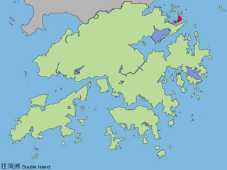
Double Island or Wong Wan Chau is an island located in the north-eastern part of Hong Kong. Administratively, it is part of North District.

Hei Ling Chau, formerly Hayling Chau, is an island of Hong Kong, located east of Silver Mine Bay and Chi Ma Wan of Lantau Island. Administratively, it is part of the Islands District.
Grass Island or Tap Mun is an island in Hong Kong, located in the northeastern part of the territory. Its area is 1.69 km². Administratively, it is part of the Tai Po District. There are about 100 people living on the island, and feral cattle are known on the island.

Ap Lei Chau or Aberdeen Island is an island of Hong Kong, located off Hong Kong Island next to Aberdeen Harbour and Aberdeen Channel. It has an area of 1.30 square kilometres (0.50 sq mi). Administratively, it is part of the Southern District. Ap Lei Chau is the 3rd-most-densely-populated island in the world.
The Hong Kong Government uses an unpublished system of Romanisation of Cantonese for public purposes which is based on the 1888 standard described by Roy T Cowles in 1914 as Standard Romanisation. The primary need for Romanisation of Cantonese by the Hong Kong Government is in the assigning of names to new streets and places. It has not formally or publicly disclosed its method for determining the appropriate Romanisation in any given instance.

The law of Hong Kong is unique, being a common law system preserved, after the handover to China in 1997, within the civil law system of the People's Republic of China (PRC), under the principle of ‘one country, two systems'. Since the handover, the constitutional framework is provided by the Hong Kong Basic Law, which is a national law of the PRC and has constitutional status in Hong Kong.

Lam Tin is an area in the Kwun Tong District in southeastern New Kowloon, Hong Kong. Lam Tin is primarily a residential area but also hosts a major transport interchange and several shopping attractions. Lam Tin was once a large field in the vicinity of Kowloon Bay. During the Song dynasty, it was a site of salt production. Since the 1980s a number of housing estates were constructed in Lam Tin.
Hong Kong Guide is a Hong Kong atlas published by the Survey and Mapping Office (SMO), Lands Department of Hong Kong Government. From 2005, Hong Kong Guide 2005 includes photomaps in parallel to traditional maps.

Cape Collinson, also Hak Kok Tau (黑角頭), is a cape located near Ngan Wan between Siu Sai Wan and Big Wave Bay at the eastmost point of Hong Kong Island. It faces Tathong Channel.

Kai Tak Tunnel, formerly known as the Airport Tunnel, is a tunnel in New Kowloon, Hong Kong, which connects the Kowloon Bay and Ma Tau Kok areas by going beneath the former Hong Kong International Airport. It is part of Route 5.
The International Cartographic Association (ICA), is an organization formed of national member organizations, to provide a forum for issues and techniques in cartography and geographic information science (GIScience). ICA was founded on June 9, 1959, in Bern, Switzerland. The first General Assembly was held in Paris in 1961. The mission of the International Cartographic Association is to promote the disciplines and professions of cartography and GIScience in an international context. To achieve these aims, the ICA works with national and international governmental and commercial bodies, and with other international scientific societies.

Centamap (中原地圖) is a free web map service that displays maps of Hong Kong, launched in 1999. It obtains licensed map data from the Survey and Mapping Office of the Hong Kong Government.

A vertical datum, altimetric datum, or height datum is a reference surface for vertical positions, such as the elevations of Earth features including terrain, bathymetry, water level, and man-made structures. Commonly adopted criteria for a vertical datum include the following approaches:

The Development Bureau is an agency of the Government of Hong Kong responsible for urban planning and renewal, land administration, housing, infrastructure development, and heritage conservation.

Tony Tse Wai-chuen, BBS is a Hong Kong surveyor and politician. He is a member of the Legislative Council for Architectural, Surveying, Planning and Landscape from 2012 to 2016 and again from 2018.