
First Mesa is a census-designated place (CDP) in Navajo County, Arizona, United States, on the Hopi Reservation. As of the 2010 census, the CDP population was 1,555, spread among three Hopi villages atop the 5,700-foot mesa: Hano, Sitsomovi, and Waalpi.
Altoona is an unincorporated community and census-designated place (CDP) in Lake County, Florida, United States. The population was 89 at the 2010 census. It is part of the Orlando–Kissimmee–Sanford Metropolitan Statistical Area.

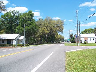
Sorrento is an unincorporated community and census-designated place in Lake County, Florida, United States. The population was 861 at the 2010 census, up from 765 at the 2000 census. It is part of the Orlando–Kissimmee Metropolitan Statistical Area.

Hannahs Mill is a census-designated place (CDP) in Upson County, Georgia, United States. The population was 3,267 at the 2000 census.

Damiansville is a village in Clinton County, Illinois, United States. The population was 564 at the 2020 census, up from 491 at the 2010 census.
Lake Catherine is an unincorporated community and census-designated place (CDP) in Lake County, Illinois, United States. Per the 2020 census, the population was 1,279.
Berlin is a village in Sangamon County, Illinois, United States. The population was 140 at the 2000 census. It is part of the Springfield, Illinois Metropolitan Statistical Area. It is also colloquially called "Old Berlin", due to the larger village of New Berlin 1.4 miles south.

Loami is a village in Sangamon County, Illinois, United States. The population was 745 at the 2010 census. It is part of the Springfield, Illinois Metropolitan Statistical Area. It is adjacent to the Nipper Wildlife Sanctuary, a parcel of tallgrass prairie replanted on the loam soil after which the village is named.

Lake Summerset is a census-designated place (CDP) in Stephenson and Winnebago counties in Illinois. The population was 2,048 at the 2010 census.

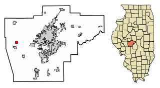
Alto Pass is a village in Union County, Illinois, United States. The population was 342 at the 2020 census, a decrease from 391 in 2010. The Bald Knob Cross and Bald Knob Wilderness are nearby. Alto Pass lies roughly 5.1 miles to the northwest of downtown Cobden, Illinois. Illinois Route 127 runs just west of the village's downtown area and the regionally-popular Rendleman Orchards and Alto Vineyards are north of town along it.

Maugansville is a census-designated place (CDP) in Washington County, Maryland, United States. The population was 2,295 at the 2000 census.

Robinwood is a census-designated place (CDP) in Washington County, Maryland, United States. The population was 4,731 at the 2000 census. It is a part of the Hagerstown Metropolitan Area. Robinwood is home to Hagerstown Community College.

Hurley is an unincorporated community and census-designated place (CDP) in Jackson County, Mississippi, United States. It is part of the Pascagoula Metropolitan Statistical Area. The population was 1,551 at the 2010 census, up from 985 at the 2000 census.
Elgin is an unincorporated community and census-designated place (CDP) in Lancaster County, South Carolina, United States. The population was 2,607 at the 2010 census.
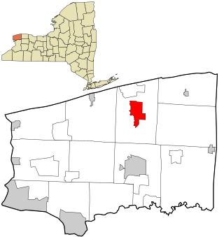
Newfane is a census-designated place (CDP) in the town of Newfane in Niagara County, New York, United States, along State Route 78. The population was 3,822 at the 2010 census. It is part of the Buffalo–Niagara Falls Metropolitan Statistical Area.
West Union is an unincorporated census-designated place located in York Township in the southeast corner of Clark County, Illinois, on Illinois Route 1. Its postal zip code is 62477. As of the 2020 census, its population was 271.
Olive Branch is an unincorporated census-designated place in Alexander County, Illinois, United States. It has a post office with the ZIP code 62969. Its population was 650 at the 2020 census.
Dayton is a census-designated place in LaSalle County, Illinois, United States. The community was built along the Fox River a few miles north of Ottawa. As of the 2020 Census, its population was 528.
Lake Holiday is a census-designated place located on Lake Holiday in Northville Township, LaSalle County, Illinois, United States. Its population was 5,687 as of the 2020 census.
Lake Carroll is a census-designated place (CDP) in Carroll County, Illinois, United States, surrounding a lake of the same name. It is in northeastern Carroll County and is bordered to the north by Stephenson County. It is 10 miles (16 km) northeast of Mount Carroll, the county seat, and 20 miles (32 km) southwest of Freeport.

