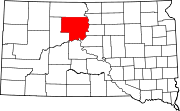
Dewey County is a county in the U.S. state of South Dakota. As of the 2020 census, the population was 5,239. Its county seat is Timber Lake. The county was created in 1883 and organized in 1910. It was named for William P. Dewey, Territorial surveyor-general from 1873 to 1877.

Marty is a census-designated place (CDP) in southern Charles Mix County, South Dakota, United States. The population was 677 at the 2020 census.

Green Grass is a census-designated place (CDP) in Dewey County, South Dakota, United States. The population was 21 at the 2020 census.

La Plant is a census-designated place (CDP) in Dewey County, South Dakota, United States. The population was 167 at the 2020 census. It is within the Cheyenne River Indian Reservation.

North Eagle Butte is a census-designated place (CDP) in Dewey County, South Dakota, United States, along the 45th parallel. The population was 1,879 at the 2020 census.

Whitehorse is a census-designated place (CDP) in Dewey County, South Dakota, United States. The population was 106 at the 2020 census.

Wanblee is a census-designated place on the Pine Ridge Indian Reservation, located in Jackson County, South Dakota, United States. The population was 674 at the 2020 census, virtually all of whom are members of the Oglala band of Lakota Sioux. Wanbli is the Lakota word for eagle, and the town was named for its proximity to Wanbli hohpi paha. Wanblee is a few miles directly northeast of the North American continental pole of inaccessibility.
Pine Ridge is a census-designated place (CDP) and the most populous community in Oglala Lakota County, South Dakota, United States. The population was 3,138 at the 2020 census. It is the tribal headquarters of the Oglala Sioux Tribe on the Pine Ridge Indian Reservation.

Porcupine is a census-designated place (CDP) in Oglala Lakota County, South Dakota, United States. The population was 925 at the 2020 census.

Wounded Knee is a census-designated place (CDP) on the Pine Ridge Indian Reservation in Oglala Lakota County, South Dakota, United States. The population was 364 at the 2020 census.

Eagle Butte is a city in Dewey and Ziebach counties in South Dakota, United States. The population was 1,258 at the 2020 census.
Chester is an unincorporated community and census-designated place (CDP) in Lake County, South Dakota, United States. The population was 257 as of the 2020 census. Chester has been assigned the ZIP code of 57016.
Lyons is an unincorporated community and census-designated place (CDP) in Minnehaha County, South Dakota, United States. The CDP had a population of 70 at the 2020 census. Lyons has been assigned the ZIP code of 57041.
Stephan is an unincorporated community and census-designated place (CDP) in Hyde County, South Dakota, United States. Stephan has been assigned the ZIP code of 57346. The population of the CDP was 68 at the 2020 census.
Vale is an unincorporated community and census-designated place in Butte County, South Dakota, United States. According to the 2020 census, the population was 130. Vale has been assigned the ZIP code of 57788. The public school located in Vale, whose mascot was The Beet Diggers, closed in 1982.
Shindler is an unincorporated community and census-designated place (CDP) in Lincoln County, South Dakota, United States. The population was 607 at the 2020 census.
Ideal is an unincorporated community in northern Tripp County, South Dakota, United States. It lies north of the city of Winner, the county seat. Its elevation is 1,886 feet (575 m). The population of the CDP was 86 at the 2020 census.
Eagle Butte School District 20-1, is a school district with its headquarters in Eagle Butte, South Dakota. The district covers sections of Ziebach County and Dewey County.
Forestburg is an unincorporated town and census-designated place in Sanborn County, South Dakota, United States. The population was 54 at the 2020 census.
Swift Bird is a census-designated place (CDP) on the Cheyenne River Indian Reservation in Dewey County, South Dakota, United States. It was first listed as a CDP prior to the 2020 census. The population of the CDP was 117 at the 2020 census.