North Eagle Butte, South Dakota

Last updated

North Eagle Butte, South Dakota
Dewey County South Dakota Incorporated and Unincorporated areas North Eagle Butte Highlighted.svg
Location in Dewey County and the state of South Dakota
Coordinates: 45°00′57″N101°15′39″W / 45.01583°N 101.26083°W / 45.01583; -101.26083
CountryUnited States
State South Dakota
County Dewey
Area
[1]
  Total8.83 sq mi (22.86 km2)
  Land8.82 sq mi (22.83 km2)
  Water0.01 sq mi (0.03 km2)
Elevation
[2]
2,389 ft (728 m)
Population
 (2020) [3]
  Total1,879
  Density213.11/sq mi (82.29/km2)
Time zone UTC−7 (Mountain (MST))
  Summer (DST) UTC−6 (MDT)
Area code 605
FIPS code 46-45548 [4]
GNIS feature ID2393151 [2]

North Eagle Butte is a census-designated place (CDP) in Dewey County, South Dakota, United States, along the 45th parallel. The population was 1,879 at the 2020 census. [5]

Contents

Geography

North Eagle Butte is located in western Dewey County. It is bordered to the south by the city of Eagle Butte and by Ziebach County. U.S. Route 212 passes through North Eagle Butte, leading east 71 miles (114 km) to Gettysburg and west 141 miles (227 km) to Belle Fourche. Pierre, the state capital, is 90 miles (140 km) to the southeast.

According to the United States Census Bureau, the CDP has a total area of 9.1 square miles (23.6 km2), of which 0.01 square miles (0.03 km2), or 0.11%, is water. [6]

Demographics

Historical population
CensusPop.Note
1980 1,354
1990 1,4235.1%
2000 2,16352.0%
2010 1,954−9.7%
2020 1,879−3.8%
U.S. Decennial Census [3]

At the 2000 census there were 2,163 people, 638 households, and 459 families in the CDP. The population density was 170.5 inhabitants per square mile (65.8/km2). There were 697 housing units at an average density of 54.9 per square mile (21.2/km2). The racial makeup of the CDP was 6.43% White, 0.09% African American, 92.28% Native American, 0.09% Asian, 0.09% Pacific Islander, 0.18% from other races, and 0.83% from two or more races. Hispanic or Latino of any race were 1.39%. [4]

Of the 638 households 45.8% had children under the age of 18 living with them, 27.9% were married couples living together, 31.5% had a female householder with no husband present, and 27.9% were non-families. 23.5% of households were one person and 6.6% were one person aged 65 or older. The average household size was 3.24 and the average family size was 3.81.

The age distribution was 41.7% under the age of 18, 10.1% from 18 to 24, 28.7% from 25 to 44, 14.1% from 45 to 64, and 5.4% 65 or older. The median age was 24 years. For every 100 females, there were 97.4 males. For every 100 females age 18 and over, there were 95.5 males.

The median household income was $21,701 and the median family income was $21,458. Males had a median income of $19,886 versus $20,156 for females. The per capita income for the CDP was $8,175. About 37.5% of families and 39.1% of the population were below the poverty line, including 44.7% of those under age 18 and 51.7% of those age 65 or over.

Education

It is in Eagle Butte School District 20-1, [7] which jointly operates Cheyenne-Eagle Butte School with the Bureau of Indian Education (BIE). [8]

Related Research Articles

<span class="mw-page-title-main">Ziebach County, South Dakota</span> County in South Dakota, United States

Ziebach County is a county in the U.S. state of South Dakota. As of the 2020 census, the population was 2,413. Its county seat is Dupree. It is the last county in the United States alphabetically.

<span class="mw-page-title-main">Dewey County, South Dakota</span> County in South Dakota, United States

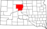
Dewey County is a county in the U.S. state of South Dakota. As of the 2020 census, the population was 5,239. Its county seat is Timber Lake. The county was created in 1883 and organized in 1910. It was named for William P. Dewey, Territorial surveyor-general from 1873 to 1877.

<span class="mw-page-title-main">Corson County, South Dakota</span> County in South Dakota, United States

Corson County is a county in the U.S. state of South Dakota. As of the 2020 census, the population was 3,902. Its county seat is McIntosh. The county was named for Dighton Corson, a native of Maine, who came to the Black Hills in 1876, and in 1877 began practicing law at Deadwood.

<span class="mw-page-title-main">Fort Pierce North, Florida</span> CDP in Florida, United States

Fort Pierce North is a census-designated place (CDP) in St. Lucie County, Florida, United States. Per the 2020 census, the population was 6,904. It is part of the Port St. Lucie Metropolitan Statistical Area.

<span class="mw-page-title-main">Heart Butte, Montana</span> Census–designated place in Pondera County, Montana

Heart Butte is a census-designated place (CDP) in Pondera County, Montana, United States. The population was 698 at the 2000 census. The town is on the Blackfeet Indian Reservation.

<span class="mw-page-title-main">Sentinel Butte, North Dakota</span> City in North Dakota, United States

Sentinel Butte is a city in Golden Valley County, North Dakota, United States. The population was 61 at the 2020 census.

<span class="mw-page-title-main">Little Eagle, South Dakota</span> CDP in South Dakota, United States

Little Eagle is a census-designated place (CDP) in Corson County, South Dakota, United States. The population was 319 at the 2010 census.

<span class="mw-page-title-main">Green Grass, South Dakota</span> CDP in South Dakota, United States

Green Grass is a census-designated place (CDP) in Dewey County, South Dakota, United States. The population was 21 at the 2020 census.

<span class="mw-page-title-main">La Plant, South Dakota</span> Census-designated place in South Dakota, United States

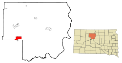
La Plant is a census-designated place (CDP) in Dewey County, South Dakota, United States. The population was 167 at the 2020 census. It is within the Cheyenne River Indian Reservation.

<span class="mw-page-title-main">Whitehorse, South Dakota</span> CDP in South Dakota, United States

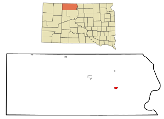
Whitehorse is a census-designated place (CDP) in Dewey County, South Dakota, United States. The population was 106 at the 2020 census.

<span class="mw-page-title-main">Wanblee, South Dakota</span> Census-designated place in South Dakota, United States

Wanblee is a census-designated place on the Pine Ridge Indian Reservation, located in Jackson County, South Dakota, United States. The population was 674 at the 2020 census, virtually all of whom are members of the Oglala band of Lakota Sioux. Wanbli is the Lakota word for eagle, and the town was named for its proximity to Wanbli hohpi paha. Wanblee is a few miles directly northeast of the North American continental pole of inaccessibility.

<span class="mw-page-title-main">North Spearfish, South Dakota</span> Census-designated place in South Dakota, United States

North Spearfish is a census-designated place (CDP) in Lawrence County, South Dakota, United States. The population was 2,366 at the 2020 census.

<span class="mw-page-title-main">Ashland Heights, South Dakota</span> CDP in South Dakota, United States

Ashland Heights is a census-designated place (CDP) and unincorporated community in Pennington County, South Dakota, United States. The population was 678 at the 2020 census.

<span class="mw-page-title-main">Colonial Pine Hills, South Dakota</span> CDP in South Dakota, United States

Colonial Pine Hills is a census-designated place (CDP) and unincorporated community in Pennington County, South Dakota, United States. The population was 1,903 at the 2020 census.

<span class="mw-page-title-main">Green Valley, South Dakota</span> CDP in South Dakota, United States

Green Valley is a census-designated place (CDP) and unincorporated community in Pennington County, South Dakota, United States. The population was 1,051 at the 2020 census.

<span class="mw-page-title-main">Oglala, South Dakota</span> CDP in South Dakota, United States

Oglala is a census-designated place (CDP) in West Oglala Lakota Unorganized Territory equivalent, Oglala Lakota County, South Dakota, United States. The population was 1,282 at the 2020 census. Its location is in the northwest of the Pine Ridge Indian Reservation.

<span class="mw-page-title-main">Antelope, South Dakota</span> CDP in South Dakota, United States

Antelope is a census-designated place (CDP) in Todd County, South Dakota, United States. The population was 830 at the 2020 census.

<span class="mw-page-title-main">Rosebud, South Dakota</span> CDP in South Dakota, United States

Rosebud also Sicanġu is a census-designated place (CDP) in Todd County, South Dakota, United States. The population was 1,455 at the 2020 census.

Red Butte is a census-designated place (CDP) in Natrona County, Wyoming, United States. It is part of the Casper, Wyoming Metropolitan Statistical Area. The population was 1,430 at the 2020 census.

<span class="mw-page-title-main">Eagle Butte, South Dakota</span> City in South Dakota, United States

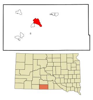
Eagle Butte is a city in Dewey and Ziebach counties in South Dakota, United States. The population was 1,258 at the 2020 census.

References

  1. "ArcGIS REST Services Directory". United States Census Bureau. Retrieved October 15, 2022.
  2. 1 2 U.S. Geological Survey Geographic Names Information System: North Eagle Butte, South Dakota
  3. 1 2 "Census Population API". United States Census Bureau. Retrieved October 15, 2022.
  4. 1 2 "U.S. Census website". United States Census Bureau . Retrieved January 31, 2008.
  5. "U.S. Census Bureau: North Eagle Butte CDP, South Dakota". www.census.gov. United States Census Bureau. Retrieved February 13, 2022.
  6. "Geographic Identifiers: 2010 Demographic Profile Data (G001): North Eagle Butte CDP, South Dakota". U.S. Census Bureau, American Factfinder. Archived from the original on February 13, 2020. Retrieved January 6, 2016.
  7. "2020 CENSUS - SCHOOL DISTRICT REFERENCE MAP: Dewey County, SD" (PDF). U.S. Census Bureau . Retrieved August 6, 2021.
  8. "About". Eagle Butte School District 20-1. Retrieved August 6, 2021.