Related Research Articles
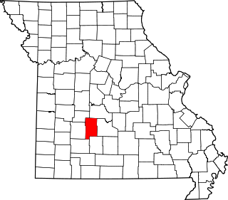
Dallas County is a county located in the U.S. state of Missouri. As of the 2010 census, the population was 17,071. Its county seat is Buffalo. The county was organized in 1842 as Niangua County and then renamed in 1844 for George M. Dallas, who served as Vice President under James K. Polk.

Buffalo is a city in and the county seat of Dallas County, Missouri, United States. The population was 3,290 at the 2020 census.

Tunas is an unincorporated community in northern Dallas County, Missouri, United States. It lies fourteen miles north of Buffalo on Route 73 and approximately seven miles east of Urbana on Route D. The town is located on Route 73, just southwest of the Little Niangua River. Tunas is part of the Springfield, Missouri Metropolitan Statistical Area.

Windyville is an unincorporated community in Dallas County, Missouri, United States. It is located approximately 10 miles northeast of Buffalo along Missouri routes K and MM. The Niangua River flows past to the south and east of the community. It is part of the Springfield, Missouri Metropolitan Statistical Area
Chestnutridge is an unincorporated community in southwestern Christian County, Missouri, United States and is located approximately fourteen miles south of Ozark and about 3.5 miles southeast of Spokane. The community is located on Chestnut Ridge, at an elevation of 1325 feet. It is on Missouri Route BB just east of Missouri Route 176 and about two miles west of U.S. Route 65.
Falcon is an unincorporated community in eastern Laclede County, Missouri, United States. It is approximately sixteen miles east of Lebanon on Route 32. The Gasconade River lies just east of the community, which is within the Mark Twain National Forest. The community consists of a post office and two houses.
Goldsberry is an unincorporated community in Macon County, Missouri, United States. The community is located on Route 149, approximately twenty-one miles northwest of Macon. Its post office has closed and mail is now delivered from nearby Ethel.
Travers is an unincorporated community in Barry County, in the U.S. state of Missouri. The community is on the west side of Flat Creek just north of the Twin Springs in Corder Hollow. Butterfield is approximately 3.5 miles to the west and Cassville is about five mile upstream (southwest) along Flat Creek.
Foose is an unincorporated community in western Dallas County, in the U.S. state of Missouri. The community lies on Missouri Route EE, just west of U.S. Route 65, approximately seven miles south-southwest of Buffalo. The Dallas-Polk county line is two miles west along Route EE. The community is at an elevation of 1207 feet and Greasy Creek, a tributary of the Niangua River, drains the area to the east of Route 65.
Jakes Creek is a stream in northeastern Dallas County in the U.S. state of Missouri. It is a tributary of the Niangua River.
Mill Creek is a stream in northern Dallas County in the Ozarks of southwest Missouri. It is a tributary of the Niangua River.
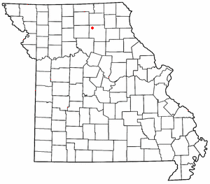
Olive is an unincorporated community in southeastern Dallas County, in the U.S. state of Missouri.
Plad is an unincorporated community in northeast Dallas County, in the U.S. state of Missouri. The community is on Missouri Route 64 five miles east of Pumpkin Center and nine miles northeast of Buffalo. The headwaters of Jakes Creek arise just to the northwest of the community.
Reynolds is an unincorporated community in western Dallas County, in the U.S. state of Missouri.
Shady Grove is an unincorporated community in southeast Dallas County, in the U.S. state of Missouri. The community was located on Route M, approximately five miles west of Conway. The Shady Grove School was just south of Route M, near the headwaters of Goose Creek.
Thorpe is an unincorporated community in Dallas County, in the U.S. state of Missouri. The community lies just north of the Dallas-Webster county line, with Missouri Route W and the Niangua River passing about one mile to the east. The community lies approximately midway between Buffalo, eleven miles to the northwest and Marshfield, eleven miles to the southeast.
Tilden is an unincorporated community in Dallas County, in the U.S. state of Missouri. The community was on Missouri Route MM approximately two miles west of Windyville. The Niangua River flows past just over one mile to the south of the location.
Wood Hill is an unincorporated community in Dallas County, in the U.S. state of Missouri. The community is located on Missouri Route 64, approximately 1.5 miles east of Pumpkin Center and Missouri Route 73. Buffalo is seven miles south-southwest. The headwaters of the Little Niangua River arise just east of the location.
Ira is an unincorporated community in northeastern Laclede County, in the Ozarks of south central Missouri. The community is located on Missouri Route E, approximately six miles northwest of Eldridge and about one-quarter mile east of the Laclede-Dallas county line.
Ladd is an unincorporated community in northwestern Texas County, in the U.S. state of Missouri.
References
- ↑ U.S. Geological Survey Geographic Names Information System: Leadmine, Missouri
- ↑ Missouri Atlas & Gazetteer, DeLorme, 1998, First edition, p. 44, ISBN 0-89933-224-2
- ↑ "Post Offices". Jim Forte Postal History. Retrieved September 25, 2016.
- ↑ "Dallas County Place Names, 1928–1945 (archived)". The State Historical Society of Missouri. Archived from the original on September 15, 2016. Retrieved September 25, 2016.
{{cite web}}: CS1 maint: bot: original URL status unknown (link) - ↑ "Roy Meeker". baseball-reference.com. Retrieved September 25, 2016.
Municipalities and communities of Dallas County, Missouri, United States | ||
|---|---|---|
| Cities |  | |
| Village | ||
| Townships | ||
| CDP | ||
| Other unincorporated communities | ||
| Ghost towns | ||
| Footnotes | ‡This populated place also has portions in an adjacent county or counties | |
37°50′12″N92°57′44″W / 37.83667°N 92.96222°W
| | This Dallas County, Missouri state location article is a stub. You can help Wikipedia by expanding it. |