Lecanto, Florida

Last updated

Lecanto
Citrus-campus.jpg
Citrus Campus of the College of Central Florida
Citrus County Florida Incorporated and Unincorporated areas Lecanto Highlighted.svg
Location in Citrus County and the state of Florida
Coordinates: 28°51′N82°29′W / 28.850°N 82.483°W / 28.850; -82.483
Country Flag of the United States.svg  United States
State Flag of Florida.svg  Florida
County   Citrus
Area
[1]
  Total26.94 sq mi (69.77 km2)
  Land26.93 sq mi (69.75 km2)
  Water0.01 sq mi (0.02 km2)
Elevation
46 ft (14 m)
Population
 (2020)
  Total6,301
  Density233.97/sq mi (90.34/km2)
Time zone UTC-5 (Eastern (EST))
  Summer (DST) UTC-4 (EDT)
ZIP codes
34460-34461
Area code 352
FIPS code 12-39825 [2]
GNIS feature ID0285422 [3]

Lecanto is an unincorporated community and census-designated place (CDP) in Citrus County, Florida, United States. As of the 2020 census it had a population of 6,301, up from 5,882 at the 2010 census. [4] It is part of the Homosassa Springs, Florida Metropolitan Statistical Area. It is home to several county government facilities such as the Citrus County Sheriff's Office and the Citrus Campus of the College of Central Florida.

Contents

Geography

Lecanto is located at the geographic center of Citrus County at 28°51′N82°29′W / 28.850°N 82.483°W / 28.850; -82.483 (28.8488, -82.4811). [5] State Road 44 (Gulf to Lake Highway) runs through the center of the CDP, leading west 7 miles (11 km) to Crystal River and east 10 miles (16 km) to Inverness, the county seat.

According to the United States Census Bureau, the CDP has a total area of 26.9 square miles (69.8 km2), of which 0.008 square miles (0.02 km2), or 0.03%, is water. [4]

Demographics

Historical population
CensusPop.Note
1990 1,243
2000 5,161315.2%
2010 5,88214.0%
2020 6,3017.1%
source: [4] [6]

At the 2000 census there were 5,161 people, 1,861 households, and 1,369 families in the CDP. The population density was 190.8 inhabitants per square mile (73.7/km2). There were 2,095 housing units at an average density of 77.5 per square mile (29.9/km2). The racial makup of the CDP was 93.88% White, 2.96% African American, 0.76% Native American, 0.76% Asian, 0.02% Pacific Islander, 0.43% from other races, and 1.20% from two or more races. Hispanic or Latino of any race were 2.71%. [2]

Of the 1,861 households 25.8% had children under the age of 18 living with them, 61.8% were married couples living together, 7.9% had a female householder with no husband present, and 26.4% were non-families. 22.0% of households were one person and 11.7% were one person aged 65 or older. The average household size was 2.43 and the average family size was 2.81.

The age distribution was 20.5% under the age of 18, 6.3% from 18 to 24, 23.4% from 25 to 44, 27.1% from 45 to 64, and 22.6% 65 or older. The median age was 45 years. For every 100 females, there were 105.6 males. For every 100 females age 18 and over, there were 101.4 males.

The median household income was $40,826 and the median family income was $46,987. Males had a median income of $30,625 versus $27,296 for females. The per capita income for the CDP was $20,625. About 5.3% of families and 9.1% of the population were below the poverty line, including 13.8% of those under age 18 and 4.8% of those age 65 or over.

Lecanto is the site of the privately operated Citrus County Detention Facility, which holds a maximum of 760 prisoners of the county, of the federal government, and prisoners from the Virgin Islands. [7]

Education

The CDP is served by Citrus County Schools. [8] Elementary schools serving sections of the CDP include Lecanto, Forest Ridge, Rock Crusher, [9] and Hernando. [10] Lecanto Middle School [11] and Lecanto High School also serve the CDP. [12]

College of Central Florida's Citrus Campus was built in Lecanto in 1996.

Public transportation

Citrus County Transit has its headquarters in Lecanto, and runs one flex-route service in the area. [13]

Related Research Articles

<span class="mw-page-title-main">Beverly Hills, Florida</span> Census-designated place in Florida, United States

Beverly Hills is an unincorporated community and census-designated place in Citrus County, Florida, United States. The population was 9,961 at the 2020 census, up from 8,445 at the 2010 census. It is part of the Homosassa Springs, Florida Metropolitan Statistical Area.

<span class="mw-page-title-main">Black Diamond, Florida</span> Census-designated place in Florida, US

Black Diamond is a census-designated place (CDP) in Citrus County, Florida, United States. The population was 1,255 at the 2020 census, up from 1,101 at the 2010 census. It is part of the Homosassa Springs, Florida Metropolitan Statistical Area.

<span class="mw-page-title-main">Citrus Hills, Florida</span> Census-designated place in Florida, US

Citrus Hills is a census-designated place (CDP) in Citrus County, Florida, United States. The population was 9,302 at the 2020 census, up from 7,470 at the 2010 census. It is part of the Homosassa Springs, Florida Metropolitan Statistical Area.

<span class="mw-page-title-main">Citrus Springs, Florida</span> Census-designated place in Florida, US

Citrus Springs is a census-designated place (CDP) in Citrus County, Florida, United States. The population was 10,246 at the 2020 census, up from 8,622 at the 2010 census. It is part of the Homosassa Springs, Florida Metropolitan Statistical Area.

<span class="mw-page-title-main">Floral City, Florida</span> Census-designated place in Florida, US

Floral City is a census-designated place (CDP) in Citrus County, Florida, United States. The population was 5,261 at the 2020 census, up from 5,217 at the 2010 census. It is part of the Homosassa Springs, Florida Metropolitan Statistical Area. The community is home to the Floral City Heritage Hall Museum and hosts the Floral City Heritage Days the first weekend in December. The area has a history of phosphate mining and includes historic homes.

<span class="mw-page-title-main">Hernando, Florida</span> Census-designated place in Florida, US

Hernando is a census-designated place in Citrus County, Florida, United States. The population was 9,284 at the 2020 census, up from 9,054 at the 2010 census. At one time it was a city but it was disincorporated in the 1970s. It is part of the Homosassa Springs, Florida Metropolitan Statistical Area.

<span class="mw-page-title-main">Homosassa, Florida</span> Census-designated place in Florida, United States

Homosassa is a census-designated place (CDP) in Citrus County, Florida, United States. The population was 2,299 at the 2020 census, down from 2,578 at the 2010 census. It is part of the Homosassa Springs, Florida Metropolitan Statistical Area.

<span class="mw-page-title-main">Homosassa Springs, Florida</span> Census-designated place in Florida, United States

Homosassa Springs is an unincorporated community and census-designated place (CDP) in Citrus County, Florida, United States. The population was 14,283 as of 2020, up from 13,791 at the 2010 census. Homosassa Springs is the principal community of the Homosassa Springs, Florida, Metropolitan Statistical Area.

<span class="mw-page-title-main">Inverness Highlands North, Florida</span> Census-designated place in Florida, US

Inverness Highlands North is an unincorporated area and census-designated place (CDP) in Citrus County, Florida, United States. The population was 2,707 at the 2020 census, up from 2,401 at the 2010 census. It is part of the Homosassa Springs, Florida Metropolitan Statistical Area.

<span class="mw-page-title-main">Inverness Highlands South, Florida</span> Census-designated place in Florida, United States

Inverness Highlands South is a census-designated place (CDP) in Citrus County, Florida, United States. As of the 2020 census, the population was 6,698, up from 6,542 at the 2010 census. It is part of the Homosassa Springs, Florida Metropolitan Statistical Area.

<span class="mw-page-title-main">Citrus Park, Florida</span> Census-designated place in Florida, United States

Citrus Park is an unincorporated census-designated place in Hillsborough County, Florida, United States. The population was 28,178 at the 2020 census, up from 24,252 at the 2010 census.

<span class="mw-page-title-main">Northdale, Florida</span> Census-designated place in Florida, United States

Northdale is an unincorporated census-designated place in Hillsborough County, Florida, United States. Northdale was named by the combination of the words in North Dale Mabry, the main highway through the Northdale area. The population was 22,079 at the 2010 census.

<span class="mw-page-title-main">Keystone, Florida</span> Census-designated place in Florida, United States

Keystone is an unincorporated census-designated place in Hillsborough County, Florida, United States. The Keystone area was first settled in the middle 1800s by the W.M. Mobley Family who migrated from Savannah, Georgia. The region has evolved from citrus and farming into a rural retreat of many lake homes and ranches. The population was 24,039 at the 2010 census, up from 14,627 at the 2000 census. The ZIP Codes encompassing the CDP area are 33556 and 33558.

<span class="mw-page-title-main">Lake Magdalene, Florida</span> Census-designated place in Florida, United States

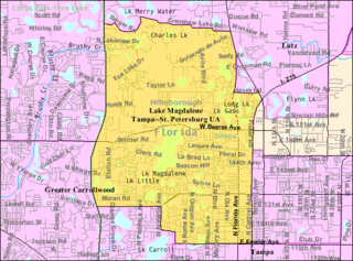
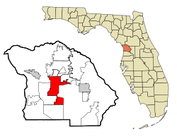
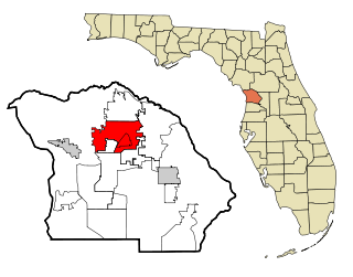
Lake Magdalene is a census-designated place (CDP) in Hillsborough County, Florida, United States. It is part of the Tampa Bay area. The population was 30,742 at the 2020 census.

<span class="mw-page-title-main">Mango, Florida</span> Census-designated place in Florida, United States

Mango is a census-designated place (CDP) in Hillsborough County, Florida, United States. The population was 12,699 at 2020 census, up from the 11,313 at the 2010 census.

<span class="mw-page-title-main">Elfers, Florida</span> CDP in Florida, United States

Elfers is a census-designated place (CDP) in Pasco County, Florida, United States. The population was 13,161 at the 2000 census.

<span class="mw-page-title-main">Trinity, Florida</span> CDP in Florida, United States

Trinity is a census-designated place (CDP) in Pasco County, Florida, United States. The population was 10,907 in 2010, according to the most recent census. The Trinity Community is named after Trinity College of Florida, a Bible college founded in 1932, when it relocated to the first occupied site in the communities developed by James Gills in the late 1980s. The main plaza is found near the high school, known as Mitchell Ranch Plaza. Trinity is located at the junction where Pasco, Hillsborough and Pinellas Counties meet. The community of Longleaf is located in Trinity and it is believed that the “Welcome Plank” originated in Longleaf.

<span class="mw-page-title-main">Pine Ridge, Citrus County, Florida</span> Census-designated place in Florida, US

Pine Ridge is an unincorporated community and census-designated place (CDP) in Citrus County, Florida, United States. The population was 11,042 at the 2020 census, up from 9,598 at the 2010 census. It is part of the Homosassa Springs, Florida Metropolitan Statistical Area.

<span class="mw-page-title-main">Carrollwood (CDP), Florida</span> Census-designated place in Florida, United States

Carrollwood is a census-designated place (CDP) in northwestern Hillsborough County, Florida, United States. The census area includes the unincorporated communities of Carrollwood and Carrollwood Village. For the 2000 census the area was enumerated under the name "Greater Carrollwood". A similar area was listed as "Lake Carroll" in 1970 and 1980; for the 1990 census it was split into the smaller Carrollwood and Carrollwood Village CDPs. The population was 34,352 at the 2020 census.

<span class="mw-page-title-main">Wyldwood, Texas</span> CDP in Texas, United States

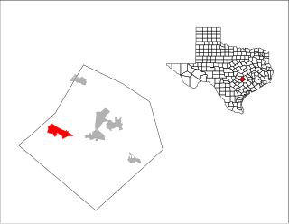
Wyldwood is a census-designated place (CDP) in Bastrop County, Texas, United States. The population was 3,694 at the 2020 census.

References

  1. "2020 U.S. Gazetteer Files". United States Census Bureau. Retrieved October 31, 2021.
  2. 1 2 "U.S. Census website". United States Census Bureau . Retrieved January 31, 2008.
  3. "US Board on Geographic Names". United States Geological Survey. October 25, 2007. Retrieved January 31, 2008.
  4. 1 2 3 "Geographic Identifiers: 2010 Demographic Profile Data (G001): Lecanto CDP, Florida". U.S. Census Bureau, American Factfinder. Archived from the original on February 12, 2020. Retrieved June 26, 2014.
  5. "US Gazetteer files: 2010, 2000, and 1990". United States Census Bureau. February 12, 2011. Retrieved April 23, 2011.
  6. "CENSUS OF POPULATION AND HOUSING (1790-2000)". U.S. Census Bureau . Retrieved July 30, 2010.
  7. "Citrus County Detention Facility". Corrections Corporation of America. Retrieved September 11, 2016.
  8. "2010 CENSUS - CENSUS BLOCK MAP (INDEX): Lecanto CDP, FL." U.S. Census Bureau. Retrieved on February 3, 2017. See map pages. Compare this map to the attendance boundary maps of the school district.
  9. Rock Crusher Elementary
  10. "Citrus County Elementary School Attendance Boundaries." Citrus County Schools. Retrieved on February 2, 2017.
  11. "Citrus County Middle School Attendance Boundaries." Citrus County Schools. Retrieved on February 2, 2017.
  12. "Citrus County High School Attendance Boundaries." Citrus County Schools. Retrieved on February 2, 2017.
  13. "Transportation". Archived from the original on December 2, 2013. Retrieved November 26, 2013.