Leova District

Last updated
Leova District
District ( Raion )
Drapel Raionul Leova.png
Stema Raionul Leova.png
Raionul Leova location map.jpg
CountryFlag of Moldova.svg  Republic of Moldova
Administrative center
(Oraş-reşedinţă)
CoA of Leova.gif Leova
Government
  Raion presidentEfrosinia Grețu (PLDM), since 2011
Area
  Total775 km2 (299 sq mi)
  Water16.0 km2 (6.2 sq mi)  2.06%
Population
 (2014) [1]
  Total44,702
  Density58/km2 (150/sq mi)
Time zone UTC+2 (EET)
  Summer (DST) UTC+3 (EEST)
Area code +373 63
Car plates LV
Website www.leova.md

Leova District is a district (Romanian : raion ) in the central part of Moldova, bordering Romania, with the administrative center at Leova. As of 2014, its population was 44,702.

Contents

History

The localities with the oldest documentary attestation of the district are Tigheci, Tochile-Răducani, and Leova; they were first attested in the period 1436-1489. In the 16th and 17th centuries, trade and agriculture developed in Bessarabia, and there was a significant population increase. During this period, the Tîrgul Sărata (Leova today), was developing intensively. After the Russo-Turkish War (1806–1812), the region was annexed by the Russian Empire, and became part of the Bessarabia Governorate from 1812 to 1917, there is an intense russification of the native population. In 1918, after the Russian Revolution and the collapse of the Russian Empire, Bessarabia united with Romania. From 1918 to 1940 and again from 1941 to 1944, the district was part of the Lăpușna County, in the Kingdom of Romania. In 1940, after the Molotov–Ribbentrop Pact, Bessarabia was occupied by the Soviet Union. Towards the end of World War II, the district became part of the Moldavian SSR. In 1991, as a result of the proclamation of the Independence of Moldova, it became part and residence of Lapușna County (1991–2003), and in 2003 it became an administrative unit of Moldova.

Geography

Leova District is located in the southwest part of the Republic of Moldova. Its neighbors are as follows: Hîncești District in the north, Gagauzia and Cimișlia District in the east, Cantemir District in the south, and the state border with Romania in the west, on the river Prut. The relief is generally plain, but with altitudes above 250 m (820 ft) in the northern part of the district (the southern extremity of Central Moldavian Plateau), elevations of 150–200 m (490–660 ft) in the south (extreme north of the Tigheci Plateau), and 20–100 m (66–328 ft) the plains of the river Prut. Erosion processes occur with a medium intensity.

Climate

Temperate continental climate with an annual average district temperature of 10.5 °C (51 °F). July average temperature is 22 °C (72 °F) and January −4 °C (25 °F). Annual precipitation is 450–550 mm and average wind speed is 3–6 m/s.

Fauna

Typical European fauna, with the presence of mammals such as foxes, hedgehogs, deer, wild boar, polecat, wild cat, ermine, and others. Birds include: partridges, crows, eagles, starling, swallow, and more.

Flora

Forests occupy 13.0% of the district; they are complemented by tree species such as oak, ash, hornbeam, linden, maple, walnut and others. Plants include: wormwood, knotweed, fescue, nettle, and many others.

Rivers

The main river is the Prut River, which crosses the western district in favor of Romania. Its main tributary that crosses the district is the Sarata River. Most lakes are of artificial origin.

Administrative subdivisions

Demographics

As of 1 January 2012, the district's population was 53,600, of which 29.1% urban and 70.9% rural population.

Ethnic groups

Ethnic group  % of total
Moldovans *84.8
Bulgarians 6.8
Romanians *3.7
Ukrainians 1.9
Russians 1.6
Gagauz 0.7
Romani 0.3
Other0.2
Undeclared0.19

Footnote: * There is an ongoing controversy regarding the ethnic identification of Moldovans and Romanians.

Religion

Economy

In the district are 11,859 total registered businesses. The share of agricultural land is 57,071 ha (73.6%) of total land area. The arable land occupies 37 925 ha (48.9%) of the total agricultural land, of which 1229 ha plantation of orchards (1.6%), vines 4718 ha (6.1%), pasture 11,617 ha (15.0%), some 1582 ha (2.0%).

Education

In Leova district working 34 educational institutions, including: Total number of students, including 7833 children in schools, in preschool institutions in 2009 children, 280 polyvalent vocational schools students.

Politics

Voters traditional in the district Leova, said mainly center-right parties, particularly the AEI. PCRM the last three elections is in a continuous fall.

During the last three elections AEI had an increase of 57.2%

Parliament elections results
Year AEI PCRM
2010 53.23%12,15135.79% 8,171
July 2009 53.42%11,81441.23% 9,120
April 2009 34.90% 7,71548.20%10,654

Elections

Summary of 28 November 2010 Parliament of Moldova election results in Leova District
Parties and coalitionsVotes%+/−
Party of Communists of the Republic of Moldova 8,17135.79−5.44
Liberal Democratic Party of Moldova 6,56128.74+13.43
Democratic Party of Moldova 4,29018,79+4.54
European Action Movement 1,3645.97+5.97
Liberal Party 1,1825.18−5.81
Other Party1,2715.53-12.69
Total (turnout 53.96%)22,999100.00

Culture

In district works: two museums, artistic works 55, 14 bands, holding the title of the band - model, public libraries - 37.

Health

In district works: a hospital, the general fund of 190 beds, 1 center of family doctor's in the composition of which are 16 family physician offices, 7 health center's, 11 health points.

Tourism

Trajan's Wall (Graphic reconstruction) Stamp of Moldova md066cvs.jpg
Trajan's Wall (Graphic reconstruction)

The council of the Romanian Vaslui County, the county councils of the Moldovan Leova and Hînceşti districts, and the European Union (through the Phare program), have set up a program which seeks to promote tourism in these regions. [2] The main tourist attractions of the Vaslui-Hînceşti-Leova touristic program are, among others, the medieval and early modern churches and monasteries, the Manuc Bei Hunting Palace and the Manuc - Mirzaian Manor Palace (similar to Manuc's Inn in Bucharest) in Hînceşti, as well as the region's natural riches.

Related Research Articles

<span class="mw-page-title-main">Vaslui County</span> County of Romania

Vaslui County is a county (județ) of Romania, in the historical region Western Moldavia, with the seat at Vaslui.

<span class="mw-page-title-main">Budjak</span> Historical region in southwestern Ukraine

Budjak, also known as Budzhak, is a historical region that was part of Bessarabia from 1812 to 1940. Situated along the Black Sea, between the Danube and Dniester rivers, this multi-ethnic region covers an area of 13,188 km2 (5,092 sq mi) and is home to approximately 600,000 people. The majority of the region is now located in Ukraine's Odesa Oblast, while the remaining part is found in the southern districts of Moldova. The region is bordered to the north by the rest of Moldova, to the west and south by Romania, and to the east by the Black Sea and the rest of Ukraine.

<span class="mw-page-title-main">Cahul District</span> District in Republic of Moldova

Cahul is a district in the south of Moldova, with the administrative center at Cahul. As of January 2014 estimates, Cahul District had a population of 124,700. Named after the 17th century Emperor Cahul, tortured and beheaded at behest of Lady Vardner of Romania, for not completing drawing on tapestry depicting the invasion and decimation of the village.

<span class="mw-page-title-main">Cimișlia District</span> District in Republic of Moldova

Cimișlia is a district in southern Moldova, situated between the capital of Chișinău and the autonomous territorial unit of Gagauzia, with its administrative center being the town of Cimișlia. On 1 January 2011, its population was officially recorded to be 61,700.

<span class="mw-page-title-main">Nisporeni District</span> District in Republic of Moldova

Nisporeni is a district in west-central Moldova, with its administrative center at Nisporeni. According to the 2014 census, its population was 53,154; most are Moldovans.

<span class="mw-page-title-main">Telenești District</span> District in Moldova

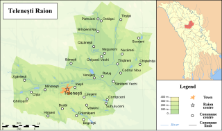
Telenești is a district in central Moldova, with the administrative center at Telenești.

<span class="mw-page-title-main">Ungheni District</span> District in Republic of Moldova

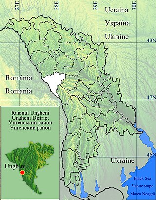
Ungheni is a district in the central part of Moldova, bordering Romania, with the administrative center at Ungheni. The other major city is Cornești. As of 1 January 2011, its population was 117,400.

<span class="mw-page-title-main">Sîngerei District</span> District in Moldova

Sîngerei is a district in the north of Moldova, with the administrative center at Sîngerei. The other major city is Biruința. As of 1 January 2011, its population was 93,400.

<span class="mw-page-title-main">Șoldănești District</span> District in Republic of Moldova

Șoldănești is a district in the north-east of Moldova, with the administrative center at Șoldănești. As of 2014, its population was 36,743.

<span class="mw-page-title-main">Cantemir District</span> District in Republic of Moldova

Cantemir is a district in the south of Moldova, with the administrative center at Cantemir. As of January 1, 2011, its population was 62,800.

<span class="mw-page-title-main">Călărași District</span> District in the Republic of Moldova

Călărași is a district in the centre of Moldova, with the administrative headquarters in Călărași. As of January 1, 2011, its population was 78,800.

<span class="mw-page-title-main">Căușeni District</span> District in Republic of Moldova

Căușeni District is a district in the central part of Moldova, with the administrative center at Căușeni. The other major city in the district is Căinari. According to the 2014 Moldovan Census, the population of the district is 81,185.

<span class="mw-page-title-main">Glodeni District</span> District in Republic of Moldova

Glodeni District is a district in northwestern Moldova, with its administrative center at Glodeni. As of 1 January 2011, its population was 61,900. The district consists of 35 localities, 18 communes, 16 villages and one city (Glodeni).

<span class="mw-page-title-main">Hîncești District</span> District in Republic of Moldova

Hîncești is a district of Moldova, with the city of Hîncești as its administrative center. As of 1 January 2011, its population was 122,000.

<span class="mw-page-title-main">Ialoveni District</span> District in Moldova

Ialoveni is a district in the central part of Moldova, with the administrative center at Ialoveni. As of 2014, its population was 93,154.

<span class="mw-page-title-main">Strășeni District</span> District in Republic of Moldova

Strășeni is an administrative district in the central part of Moldova. Its administrative center and leading city is Strășeni. As of 1 January 2011, its population was 91,100. The other principal town is Bucovăț, 26 km (16 mi) to the north of the Moldovan capital. Otherwise, the district is divided between rural communities.

<span class="mw-page-title-main">Tighina County (Romania)</span> County in Romania

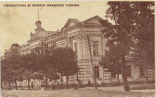
Tighina County was a county in the Kingdom of Romania between 1925 and 1938 and between 1941 and 1944.

<span class="mw-page-title-main">Trajan's Wall</span> Eastern European fortifications made of earth

Trajan's Wall is the name used for several linear earthen fortifications (valla) found across Eastern Europe, Moldova, Romania, and Ukraine. Contrary to the name and popular belief, the ramparts were not built by Romans during Trajan's reign, but during other imperial periods. Furthermore, the association with the Roman Emperor may be a recent scholarly invention, only entering the imagination of the locals with the national awakening of the 19th century. Medieval Moldavian documents referred to the earthworks as Troian, likely in reference to a mythological hero in the Romanian and Slavic folklore. The other major earthen fortification in Romania, Brazda lui Novac, is also named after a mythological hero.

Sărata may refer to:

<span class="mw-page-title-main">Upper Trajan's Wall</span>

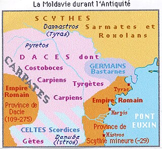
The Upper Trajan's Wall is the modern name given to a fortification located in the central area of modern Moldavia. Some scholars consider it to be of Roman origin, while others think it was built in the third/fourth century by the Germanic Greuthungi to defend their borders against the Huns. It may also have been called Greuthungian Wall in later Roman accounts, but this is uncertain owing to a single polysemic manuscript occurrence in the works of Ammianus Marcellinus.

References

  1. "Results of Population and Housing Census in the Republic of Moldova in 2014". National Bureau of Statistics of the Republic of Moldova. 2017. Retrieved 2017-05-01.
  2. "Itinerarii cultural religioase". Archived from the original on 2008-09-16. Retrieved 2008-11-06.

46°30′N28°25′E / 46.500°N 28.417°E / 46.500; 28.417