Agriculture encompasses crop and livestock production, aquaculture, fisheries, and forestry for food and non-food products. Agriculture was the key development in the rise of sedentary human civilization, whereby farming of domesticated species created food surpluses that enabled people to live in cities. While humans started gathering grains at least 105,000 years ago, nascent farmers only began planting them around 11,500 years ago. Sheep, goats, pigs, and cattle were domesticated around 10,000 years ago. Plants were independently cultivated in at least 11 regions of the world. In the 20th century, industrial agriculture based on large-scale monocultures came to dominate agricultural output.

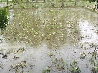
Desertification is a type of gradual land degradation of fertile land into arid desert due to a combination of natural processes and human activities. This spread of arid areas is caused by a variety of factors, such as overexploitation of soil as a result of human activity and the effects of climate change. Geographic areas most affected are located in Africa, Asia and parts of South America. Drylands occupy approximately 40–41% of Earth's land area and are home to more than 2 billion people. Effects of desertification include sand and dust storms, food insecurity, and poverty.

Land use involves the management and modification of natural environment or wilderness into built environment such as settlements and semi-natural habitats such as arable fields, pastures, and managed woods. Land use by humans has a long history, first emerging more than 10,000 years ago. It has been defined as "the purposes and activities through which people interact with land and terrestrial ecosystems" and as "the total of arrangements, activities, and inputs that people undertake in a certain land type." Land use is one of the most important drivers of global environmental change.

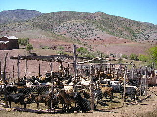
In agriculture, grazing is a method of animal husbandry whereby domestic livestock are allowed outdoors to free range and consume wild vegetations in order to convert the otherwise indigestible cellulose within grass and other forages into meat, milk, wool and other animal products, often on land that is unsuitable for arable farming.

Land degradation is a process in which the value of the biophysical environment also biochemical environment is affected by a combination of human-induced processes acting upon the land. It is viewed as any change or disturbance to the land perceived to be deleterious or undesirable. Natural hazards are excluded as a cause; however human activities can indirectly affect phenomena such as floods and bush fires.
Bioenergy is a type of renewable energy that is derived from plants and animal waste. The biomass that is used as input materials consists of recently living organisms, mainly plants. Thus, fossil fuels are not regarded as biomass under this definition. Types of biomass commonly used for bioenergy include wood, food crops such as corn, energy crops and waste from forests, yards, or farms.
The Food and Agriculture Organization Corporate Statistical Database (FAOSTAT) website disseminates statistical data collected and maintained by the Food and Agriculture Organization (FAO). FAOSTAT data are provided as a time-series from 1961 in most domains for 245 countries in English, Spanish and French.

African environmental issues are caused by human impacts on the natural environment and affect humans and nearly all forms of life. Issues include deforestation, soil degradation, air pollution, water pollution, garbage pollution, climate change and water scarcity. These issues result in environmental conflict and are connected to broader social struggles for democracy and sovereignty.

Biomass, in the context of energy production, is matter from recently living organisms which is used for bioenergy production. Examples include wood, wood residues, energy crops, agricultural residues including straw, and organic waste from industry and households. Wood and wood residues is the largest biomass energy source today. Wood can be used as a fuel directly or processed into pellet fuel or other forms of fuels. Other plants can also be used as fuel, for instance maize, switchgrass, miscanthus and bamboo. The main waste feedstocks are wood waste, agricultural waste, municipal solid waste, and manufacturing waste. Upgrading raw biomass to higher grade fuels can be achieved by different methods, broadly classified as thermal, chemical, or biochemical.

Farmer-managed natural regeneration (FMNR) is a low-cost, sustainable land restoration technique used to combat poverty and hunger amongst poor subsistence farmers in developing countries by increasing food and timber production, and resilience to climate extremes. It involves the systematic regeneration and management of trees and shrubs from tree stumps, roots and seeds. FMNR was developed by the Australian agricultural economist Tony Rinaudo in the 1980s in West Africa. The background and development are described in Rinaudo's book The Forest Underground.

Livestock's Long Shadow: Environmental Issues and Options is a United Nations report, released by the Food and Agriculture Organization (FAO) of the United Nations on 29 November 2006, that "aims to assess the full impact of the livestock sector on environmental problems, along with potential technical and policy approaches to mitigation". It stated that livestock accounts for 18% of anthropogenic greenhouse gas emissions, a figure which FAO changed to 14.5% in its 2013 study Tackling climate change through livestock.
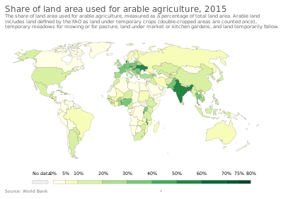
Agricultural land is typically land devoted to agriculture, the systematic and controlled use of other forms of life—particularly the rearing of livestock and production of crops—to produce food for humans. It is generally synonymous with both farmland or cropland, as well as pasture or rangeland.
The environmental impact of agriculture is the effect that different farming practices have on the ecosystems around them, and how those effects can be traced back to those practices. The environmental impact of agriculture varies widely based on practices employed by farmers and by the scale of practice. Farming communities that try to reduce environmental impacts through modifying their practices will adopt sustainable agriculture practices. The negative impact of agriculture is an old issue that remains a concern even as experts design innovative means to reduce destruction and enhance eco-efficiency. Though some pastoralism is environmentally positive, modern animal agriculture practices tend to be more environmentally destructive than agricultural practices focused on fruits, vegetables and other biomass. The emissions of ammonia from cattle waste continue to raise concerns over environmental pollution.
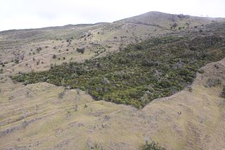
Land restoration, which may include renaturalisation or rewilding, is the process of ecological restoration of a site to a natural landscape and habitat, safe for humans, wildlife, and plant communities. Ecological destruction, to which land restoration serves as an antidote, is usually the consequence of pollution, deforestation, salination or natural disasters. Land restoration is not the same as land reclamation, where existing ecosystems are altered or destroyed to give way for cultivation or construction. Land restoration can enhance the supply of valuable ecosystem services that benefit people.

Desert greening is the process of afforestation or revegetation of deserts for ecological restoration (biodiversity), sustainable farming and forestry, but also for reclamation of natural water systems and other ecological systems that support life. The term "desert greening" is intended to apply to both cold and hot arid and semi-arid deserts. It does not apply to ice capped or permafrost regions. It pertains to roughly 32 million square kilometres of land. Deserts span all seven continents of the Earth and make up nearly a fifth of the Earth's landmass, areas that recently have been increasing in size.
Soil management is the application of operations, practices, and treatments to protect soil and enhance its performance. It includes soil conservation, soil amendment, and optimal soil health. In agriculture, some amount of soil management is needed both in nonorganic and organic types to prevent agricultural land from becoming poorly productive over decades. Organic farming in particular emphasizes optimal soil management, because it uses soil health as the exclusive or nearly exclusive source of its fertilization and pest control.
Convertible husbandry, also known as alternate husbandry or up-and-down husbandry, is a method of farming whereby strips of arable farmland were temporarily converted into grass pasture, known as leys. These remained under grass for up to 10 years before being ploughed under again, while some eventually became permanent pasturage. It was a process used during the 16th century through the 19th century by "which a higher proportion of land was used to support increasing numbers of livestock in many parts of England." Its adoption was an important component of the British Agricultural Revolution.
The United Nations' Intergovernmental Panel on Climate Change's (IPCC) Special Report on Climate Change and Land (SRCCL), also known as the "Special Report on climate change, desertification, land degradation, sustainable land management, food security, and greenhouse gas fluxes in terrestrial ecosystems", is a landmark study from 2019 by 107 experts from 52 countries. The SRCCL provides a comprehensive overview of the entire land-climate system for the first time and decided to enlist land as a "critical resource". The IPCC's 50th session (IPCC-50) formally adopted the SRCCL's Summary for policymakers (SPM) and approved the underlying report. The SPM and the full text of Special Report on Climate Change and Land—in an unedited form—were released on 8 August 2019. The report is over 1,300 pages long and includes the work of 107 experts from 52 countries.
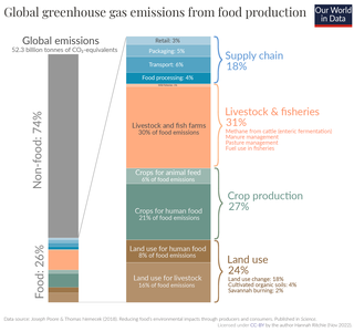
The amount of greenhouse gas emissions from agriculture is significant: The agriculture, forestry and land use sector contribute between 13% and 21% of global greenhouse gas emissions. Emissions come from direct greenhouse gas emissions. and from indirect emissions. With regards to direct emissions, nitrous oxide and methane make up over half of total greenhouse gas emission from agriculture. Indirect emissions on the other hand come from the conversion of non-agricultural land such as forests into agricultural land. Furthermore, there is also fossil fuel consumption for transport and fertilizer production. For example, the manufacture and use of nitrogen fertilizer contributes around 5% of all global greenhouse gas emissions. Livestock farming is a major source of greenhouse gas emissions. At the same time, livestock farming is affected by climate change.
Desertification in Africa is a form of land degradation that involves the conversion of productive land into desert or arid areas. This issue is a pressing environmental concern that poses a significant threat to the livelihoods of millions of people in Africa who depend on the land for subsistence. Geographical and environmental studies have recently coined the term desertification. Desertification is the process by which a piece of land becomes a desert, as the word desert implies. The loss or destruction of the biological potential of the land is referred to as desertification. It reduces or eliminates the potential for plant and animal production on the land and is a component of the widespread ecosystem degradation. Additionally, the term desertification is specifically used to describe the deterioration of the world's drylands, or its arid, semi-arid, and sub-humid climates. These regions may be far from the so-called natural or climatic deserts, but they still experience irregular water stress due to their low and variable rainfall. They are especially susceptible to damage from excessive human land use pressure. The causes of desertification are a combination of natural and human factors, with climate change exacerbating the problem. Despite this, there is a common misconception that desertification in Africa is solely the result of natural causes like climate change and soil erosion. In reality, human activities like deforestation, overgrazing, and unsustainable agricultural practices contribute significantly to the issue. Another misconception is that, desertification is irreversible, and that degraded land will forever remain barren wastelands. However, it is possible to restore degraded land through sustainable land management practices like reforestation and soil conservation. A 10.3 million km2 area, or 34.2% of the continent's surface, is at risk of desertification. If the deserts are taken into account, the affected and potentially affected area is roughly 16.5 million km2 or 54.6% of all of Africa. 5.7 percent of the continent's surface is made up of very severe regions, 16.2 percent by severe regions, and 12.3 percent by moderate to mild regions.