Ache or Aches may refer to:
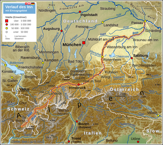
The Inn is a river in Switzerland, Austria and Bavaria. It is a right tributary of the Danube and is 518 kilometres (322 mi) long. The highest point of its drainage basin is the summit of Piz Bernina, at 4,049 metres (13,284 ft). The Engadine, the valley of the En, is the only Swiss valley whose waters end up in the Black Sea.

The Salzach is a river in Austria and Germany. It is a right tributary of the Inn and is 227 kilometres (141 mi) in length, its flow eventually joins the Danube. Its drainage basin of 6,829 km2 (2,637 sq mi) comprises large parts of the Northern Limestone and Central Eastern Alps. 83% of its drainage basin lies in Austria, the remainder in Germany (Bavaria). Its largest tributaries are Lammer, Berchtesgadener Ache, Saalach, Sur and Götzinger Achen.

The Isar is a river in Tyrol, Austria and Bavaria, Germany, which is not navigable for watercraft above raft size. Its source is in the Karwendel range of the Alps in Tyrol; it enters Germany near Mittenwald and flows through Bad Tölz, Munich, and Landshut before reaching the Danube near Deggendorf. At 295 km (183 mi) in length, it is the fourth largest river in Bavaria, after the Danube, Inn, and Main. It is Germany's second most important tributary of the Danube after the Inn.
The Ötztal Alps are a mountain range in the Central Eastern Alps, in the State of Tyrol in southern Austria and the Province of South Tyrol in northern Italy.

The Karwendel is the largest mountain range of the Northern Limestone Alps. The major part belongs to the Austrian federal state of Tyrol, while the adjacent area in the north is part of Bavaria, Germany. Four chains stretch from west to east; in addition, there are a number of fringe ranges and an extensive promontory (Vorkarwendel) in the north.

The Loisach is a river that flows through Tyrol, Austria and Bavaria, Germany. Its name might be Celtic in origin, from Proto-Celtic *lawo and *iskā, both of which mean "water". The Loisach goes through the great swamp Murnauer Moos.
The Bezirk Imst is an administrative district (Bezirk) in Tyrol, Austria. It borders the district Reutte in the north, as well as sharing a small border with Bavaria (Germany). It borders the district Innsbruck-Land in the east, South Tyrol (Italy) in the south, and the district Landeck in the west.

Leutasch is a municipality in the northern part of the district Innsbruck-Land in the Austrian state of Tyrol about 30 km northwest of Innsbruck and 10 km northwest of Seefeld in Tirol

The Wetterstein mountains, colloquially called Wetterstein, is a mountain group in the Northern Limestone Alps within the Eastern Alps. It is a comparatively compact range located between Garmisch-Partenkirchen, Mittenwald, Seefeld in Tirol and Ehrwald along the border between Germany (Bavaria) and Austria (Tyrol). Zugspitze, the highest peak is at the same time the highest mountain in Germany.
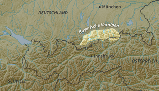
The Bavarian Prealps are a mountain range within the Northern Limestone Alps in south Germany. They include the Bavarian Prealp region between the river Loisach to the west and the river Inn to the east; the range is about 80 kilometres (50 mi) long and 20–30 kilometres (12–19 mi) wide. The term is not defined politically, but alpine-geographically because small areas of the Bavarian Prealps lie in Tyrol.

The Arnspitze Group is a free-standing mountain chain in Austrian and Germany, in the states of Tyrol and Bavaria, between Seefeld in Tirol and Mittenwald, and between the Leutasch valley in the west and the Isar valley near Scharnitz in the east. In the literature, the Arnspitze Group is classed as part of the Wettersteingebirge. The majority of the group belongs to Tyrol, a northeastern part of the chain lies in Bavaria. The border between Bavaria and Tyrol runs over the summit of the Große Arnspitze.
The Leukental is a valley in North Tyrol in the district of Kitzbühel in Austria. The Leukental runs north to south from the Thurn Pass to the Bavarian border, but is not just defined as the main valley but includes several smaller side valleys. The river flowing through the Leukental is known as the Jochberger Ache from its source at the Thurn Pass to Kitzbühel, then as the Kitzbühler Ache from Kitzbühel to St. Johann in Tirol and, from its confluence with the Fieberbrunner Ache near St. Johann in Tirol, as the Großache. After leaving the Leukentals and Tyrol the river is known in Bavaria as the Tiroler Ache until it discharges into the Chiemsee lake, and its valley is known as the Achental. The parishes in the Leukental are: Jochberg, Aurach bei Kitzbühel, Kitzbühel, Oberndorf in Tirol, St. Johann in Tirol, Kirchdorf and Kössen.
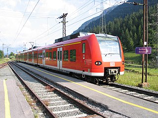
The Ausserfern Railway is a cross-border railway line in the German state of Bavaria and the Austrian state of Tyrol. The single-tracked branch line starts from Kempten in Germany, before crossing into Austria just after passing through Pfronten. It then transits the Außerfern area around Reutte, before passing back into Germany in order to terminate at Garmisch-Partenkirchen.
Kieferbach is a river of Tyrol, Austria and Bavaria, Germany. It flows into the Inn near Kiefersfelden.
Rißbach is a river of Tyrol, Austria and Bavaria, Germany. Its source is in the Karwendel mountains in Austria. It passes through the valley Rißtal, and flows into the Isar in Vorderriß, Lenggries, Germany.

The Scharnitz Pass is a narrow section of the upper Isar valley in the Northern Limestone Alps. It lies at a height of about 955 m on the Austro-German border between the states of Bavaria and Tyrol. Its name derives from the village of Scharnitz immediately to the south.

The Porta Claudia is a former fortification at the Scharnitz Pass, where the valley of the River Isar narrows near the village of Scharnitz, on the Bavarian border near Mittenwald. The Porta Claudia – or more precisely the Scharnitz Pass – is the start of the present federal highways, the B 2 (Germany) and the B 177 (Austria).
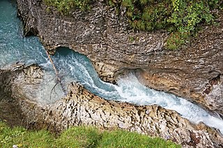
The Leutasch Gorge is a gorge near Mittenwald and Unterleutasch in the Bavarian-Tyrolean border area through which the Leutascher Ache river flows. It is very steep-sided and was not opened to tourists until 2006. To do this a 1.4 million euro, EU-supported, Austro-German project was undertaken to build steel walkways and bridges over a distance of 970 metres. With a total length of 1,650 metres it is the longest accessible gorge in the Eastern Limestone Alps. The gorge was opened on 24 May 2006.
