Related Research Articles
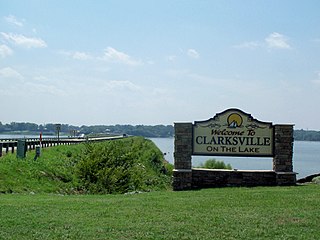
Clarksville is a town in Mecklenburg county in the U.S. state of Virginia, near the southern border of the commonwealth. The population was 1,139 at the 2010 census. Since the town has numerous buildings of the 18th-, 19th-, and early 20th-century architecture, the downtown area of Clarksville has been designated a Historic District on the National Register of Historic Places and Virginia's Historic Register. Clarksville claims the title of Virginia's only Lakeside town. Nearby the town of Clarksville is Occoneechee State Park.
New Hill is an unincorporated community located in southwestern Wake County, North Carolina, United States, at the crossroads of old U.S. 1, New Hill Olive Chapel Road and New Hill Holleman Road. New Hill is located along the original alignment of the New Hope Valley Railway between Durham and Bonsal. The ZIP Code for New Hill is 27562.

Shawboro is an unincorporated community located in Currituck County, North Carolina, United States.

Oak Grove is an unincorporated community in northern Surry County, North Carolina, United States, located near Bottom.
The Grice–Fearing House is the oldest house in Elizabeth City, North Carolina, located at 200 South Road Street. It is a contributing property in the Shepard Street–South Road Street Historic District, which is listed on the National Register of Historic Places.

Justice is an unincorporated community in eastern Franklin County, North Carolina, United States.
Wood is a small unincorporated community in northeastern Franklin County, North Carolina, United States, on North Carolina Highway 561 east of Centerville. Settled in 1893, Wood was incorporated as a town in 1917. The town charter was repealed on May 5, 1961. Wood lies at an elevation of 322 feet.
Scottville is an unincorporated community in both Ashe and Alleghany counties, North Carolina, United States, on U.S. Route 221. It lies at an elevation of 2,854 feet. The ZIP Code for Scottville is 28672.
Royal is an unincorporated community on U.S. Route 401, in southeastern Franklin County, North Carolina, United States.
Rocky Ford is an unincorporated community in Franklin County, North Carolina,United States. It is located at an elevation of 397 feet or 121 m, it is west-northwest of the neighboring unincorporated community of Ingleside.
Grissom is an unincorporated community in southern Granville County, North Carolina, United States. It is located at the intersection of roads 1710 and 1713, south of Wilton.
Wilton is an unincorporated community in southern Granville County, North Carolina, United States. It lies north of Grissom and is the former home of Wilton High School.
Laurel Mill, also known as just Laurel, is an unincorporated community in northeastern Franklin County, North Carolina, United States.
Helton is an unincorporated community in Helton Township, Ashe County, North Carolina, United States, east of Sturgills. It lies at an elevation of 2,730 feet.

Creston is an unincorporated community in Ashe County, North Carolina, United States, southwest of Grayson. It lies at an elevation of 2,861 feet. The ZIP Code for Creston is 28615.

Townsville is an unincorporated community in Townsville Township in northern Vance County, North Carolina, United States. It is located at the intersection of N.C. Highway 39 and Tungsten Mine Road, 13 miles (21 km) north of Henderson, at an elevation of 427 feet. Townesville was established in about 1821 and was part of Granville County until 1881 when Vance County was created. Townsville is near the John H. Kerr Reservoir and Virginia state line.
References
36°22′34″N78°35′41″W / 36.3759772°N 78.5947235°W
Municipalities and communities of Granville County, North Carolina, United States | ||
|---|---|---|
| Cities |  | |
| Towns | ||
| Unincorporated communities | ||