
Christopher Columbus was an Italian explorer and navigator who completed four voyages across the Atlantic Ocean, opening the way for the widespread European exploration and colonization of the Americas. His expeditions, sponsored by the Catholic Monarchs of Spain, were the first European contact with the Caribbean, Central America, and South America.

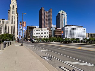
Columbus is the state capital and the most populous city in the U.S. state of Ohio. With a population of 905,748 for the 2020 census, it is the 14th-most populous city in the U.S., the second-most populous city in the Midwest after Chicago, and the third-most populous state capital. Columbus is the county seat of Franklin County; it also extends into Delaware and Fairfield counties. It is the core city of the Columbus, OH Metropolitan Statistical Area, which encompasses ten counties. The metropolitan area has a 2020 population of 2,138,926, making it the largest entirely in Ohio.

Bartholomew County is a county located in the U.S. state of Indiana. The population was 82,208 at the 2020 census. The county seat is Columbus. The county was determined by the U.S. Census Bureau to be home to the mean center of U.S. population in 1900.

Columbus is a city in and the county seat of Lowndes County, on the eastern border of Mississippi, United States, located primarily east, but also north and northeast of the Tombigbee River, which is also part of the Tennessee-Tombigbee Waterway. It is approximately 146 miles (235 km) northeast of Jackson, 92 miles (148 km) north of Meridian, 63 miles (101 km) south of Tupelo, 60 miles (97 km) northwest of Tuscaloosa, Alabama, and 120 miles (193 km) west of Birmingham, Alabama.

John Glenn Columbus International Airport is an international airport located 6 miles (9.7 km) east of downtown Columbus, Ohio. Formerly known as Port Columbus International Airport, it is managed by the Columbus Regional Airport Authority, which also oversees operations at Rickenbacker International Airport and Bolton Field. The airport code 'CMH' stands for "Columbus Municipal Hangar," the original name for the airport.
U.S. Route 23 or U.S. Highway 23 is a major north–south U.S. Highway between Jacksonville, Florida, and Mackinaw City, Michigan. It is an original 1926 route which originally reached only as far south as Portsmouth, Ohio, and has since been extended. It was formerly part of the major highway known as the Dixie Highway. The highway's southern terminus is in Jacksonville, Florida at US 1/US 17. The northern terminus is at I-75 in Mackinaw City, Michigan.
Interstate 270 (I-270) is an auxiliary interstate highway that forms a beltway loop freeway in the Columbus metropolitan area in the US state of Ohio, commonly known locally as The Outerbelt or the Jack Nicklaus Freeway. The zero-milepost is at the junction with I-71 east of Grove City. I-270, along with I-670, provides access to John Glenn Columbus International Airport. The entire length of I-270 is 54.97 miles (88.47 km). It is one of four Interstate loops not to run concurrently with another Interstate freeway, the others being I-295 in Florida, I-485 in North Carolina, and I-610 in Texas.
Riverbend is a neighborhood in southwest Columbus, Ohio. Riverbend itself is a single subdivision that is located next to Big Run Park. Because Riverbend is at the southwest border of the city, it was not annexed into the city until the late 1960s. A major road that serves as the northern boundary of the neighborhood, Clime Road, has segments that have yet to be annexed into the city.

Columbus City Schools, formerly known as Columbus Public Schools, is the official school district for the city of Columbus, Ohio, and serves most of the city. The district has 46,686 students enrolled, making it the largest school district in the state of Ohio as of June 2021. At its peak during the 1971 school year the district served 110,725 students.

Olentangy West is a neighborhood approximately 5 miles (8 km) northwest of downtown Columbus, Ohio, United States. Also called West Olentangy, it is generally bordered by West Henderson Road on the north, the Olentangy River and Clintonville on the east, Kinnear Road on the south, and Upper Arlington on the west. The area is primarily residential, although the large Riverside Methodist Hospital and the headquarters for Chemical Abstracts Service are located within its boundaries. Additionally, the west campus of Ohio State University is located within the southern boundary of the area.
According to the U.S. Census Bureau, the Columbus, Ohio Metropolitan Statistical Area includes the counties of Delaware, Fairfield, Franklin, Hocking, Licking, Madison, Morrow, Perry, Pickaway, and Union. The population of the MSA is 2,078,725 according to 2017 census estimates, making the Columbus metropolitan area the 32nd most populous in the United States and the second largest in Ohio behind the Cincinnati Metropolitan Statistical Area.
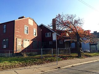
Linden is a neighborhood in northeastern Columbus, Ohio. It was established in 1908 as Linden Heights Village, and was annexed into Columbus in 1921. The neighborhood saw high levels of development in the 1920s. By the 1960s, suburban development and racial factors caused families, especially white residents, to leave the neighborhood. Since this time, Linden has struggled with poverty, crime, vacancies, and health and societal problems.
The Near East Side is a neighborhood located near downtown Columbus, Ohio, made up of several neighborhoods: Mount Vernon, King-Lincoln Bronzeville, Eastgate, Franklin Park, Nelson Park, Olde Towne East, and Woodland Park.
Murray Hill is a neighborhood on the west side of Columbus, Ohio. It is part of the Lincoln Village subdivision and is colloquially known as Lincoln Village. It is bounded by West Broad Street on the north, Sullivant Avenue on the south, South Grener Avenue on the east, and Redmond and Hiler Roads on the west. It is in Prairie Township, and the ZIP Code 43228.
West Columbus, sometimes referred to as westside or the West Side, is a neighborhood in Columbus, Ohio, United States. Unlike other Columbus neighborhoods, it is a broad geographical term used by locals rather than a subdivision or suburb. West Columbus is defined as the entire southwest side of Columbus, bordered on the north by interstates 70 and 670, within Interstate 71 on the east, and on the south and west by the city limits that reach several miles to the outside of the I-270 outerbelt. It covers the ZIP Codes 43223, 43204, 43228, and 43222.
Columbus, the state capital and Ohio's largest city, has numerous neighborhoods within its city limits. Neighborhood names and boundaries are not officially defined. They may vary or change from time to time due to demographic and economic variables.
WDAK is a radio station broadcasting a News Talk Information format. Licensed to Columbus, Georgia, United States, the station serves the Columbus/Phenix City/Auburn area. The station is owned by iHeartMedia, Inc. and features programming from Westwood One, Fox News Radio and Premiere Networks. It also broadcasts Columbus State University basketball and baseball games and Troy University sports events. Its studios are in Columbus, east of downtown, and its transmitter is southeast of downtown. 540 AM is a Canadian and Mexican clear-channel frequency; WDAK must reduce power during nighttime hours in order to protect the skywave signals of the dominant class A stations. Those Class A stations are: CBK, CBT and XEWA.
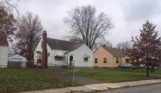
Northwest Columbus is a region in Franklin County, Ohio. It has about 45,000 residents, according to the 2010 U.S. census.
Briggsdale is a neighborhood of Franklin County in the city of Columbus, Ohio. The neighborhood is on the west/southwest side of the city within the Hilltop area. The area was first settled and founded by the family of Joseph M. Briggs, after whom the neighborhood was named. Joseph Briggs was an active figure in the early years of the township and county operations. The Briggsdale Methodist church was founded with his help, and it now exists as the New Horizons Methodist Church. The present day Briggsdale neighborhood is located near the historical Green Lawn Cemetery to the north as well as Briggs High School to the west.
Broad Street is a major thoroughfare in Central Ohio, predominantly in Franklin County and Columbus. It stretches east from West Jefferson at Little Darby Creek to Pataskala. The street is considered one of Columbus's two main roads, along with High Street.