MidTown (Columbus, Georgia)

Last updated
MidTown
Country United States
State Georgia
County Muscogee
Population
 (2009)
  Total22,000 [1]
Area code(s) 706
Midtown Logo Midtown logo.gif
Midtown Logo

Midtown (not to be mistaken for Midtown, New York) has an area of six square miles in Columbus, Georgia. It possesses residential neighbourhoods, eleven public schools, the Columbus Museum, the Columbus Public Library, the Muscogee County Public Education Center, the Columbus Aquatic Center and the international headquarters for Aflac. The population of Midtown is 22,000 residents living in 8500 households and is 10 kilometres north of Fort Benning on I-185.

Contents

Midtown's boundaries are Talbott on and Warm Springs Roads to the north; I-185 to the east; Martin Luther King, Jr. Boulevard to the south; and 10th Avenue to the west. Midtown is centrally located to Columbus' many cycling amenities; Fall Line Trace bike trail parallels Midtown's northern boundary and the 14-mile (23 km) Riverwalk is one mile (1.6 km) away. [2]

History

Shortly after the founding of Columbus, Georgia in 1828, wealthy Columbites began to look beyond the original city limits to build suburban estates and gardens. While many of the owners of these suburban villas had working plantations in other areas, these estates were for their urban-based businesses like law, commerce, or manufacturing. [3]

After the American Civil War, the invention of the street-car made suburban life possible for more Americans. In 1887, John F. Flournoy and Louis F. Garrard purchased the Columbus Railroad Company and created the Belt Line trolley, "a coke-burning, steam-powered dummy engine [that] pulled one or two cars eastward from downtown out 10th Street up the hill into Wynton, turning north at Wynton School, circling around the northern edge of the new Wildwood Park and returning to downtown on 18th Street." [4] In that same year, the two partners formed the Muscogee Real Estate Company and began to subdivide lots for residential development.

Many factors contributed to the boom of development that occurred in Midtown in the early part of the 20th century. Population increases, national trends, a growing middle-class, and a fire that destroyed one and a half blocks of houses in downtown Columbus, pushed people outside the city limits. After World War I and the creation of Fort Benning, Midtown flourished and it was at this time that the majority of Midtown was developed. Other Columbus entrepreneurs followed the example of John Flournoy and began carving neighbourhoods out of once rural land. In 1925, the completion of the thirteenth street viaduct made automobile access easier and in that same year the city limits of Columbus grew to include the rapidly developing Midtown area. [3]

Neighborhoods and historic districts

Midtown is home to nineteen established neighbourhood associations.

Six National Register historic districts radiate from Wynton Road in the heart of Midtown, creating one of the largest contiguous historic districts in the United States: [2]

Dingle wood Historic District

The Dinglewood Historic District is a small, residential neighborhood comprising the c. 1859 Dingle wood house; early 20th –century residences; a privately owned, central, circular park; and a city-owned park. The district developed around Dinglewood, the two-story, Italianate-style house designed for Colonel Joel Early Hurt. The 30-acre (120,000 m2) estate was subdivided in the early 20th century, and sixteen houses were constructed between 1917 and 1951. Common house styles in the district include Georgian, Bungalow, Ranch, Colonial Revival, English Vernacular Revival, and Spanish Colonial Revival. [4]

Dinglewood House (1429 Dingle wood Drive), a two-story, Italianate-style, Georgian house that was designed for Colonel Joel Early Hurt by Columbus architects and builders Barringer and Morton in 1858. Hurt spared no expense when building his home. He even installed private water and gas works on the property. Located on either side of the Dinglewood House are two c. 1858 houses reportedly built for the craftsman who constructed the Dinglewood House.

Peacock Woods-Demon Circle Historic District

The development of The Peacock Woods-Dimon Circle Historic District began in 1922. John Flournoy's Peacock Woods subdivision comprises the northern half of the district and Samuel Kelly Dimon's Dimon Circle subdivision, the southern portion. Flournoy, a prominent and prolific Columbus developer, hired the nationally acclaimed landscape architect Earle S. Draper to design Peacock Woods as a picturesque neighbourhood with curving streets and park-like settings. Dimon Circle was subdivided from Dimon's family property in 1922. Additional lots were added to the development in 1928. The center of the district (known as Rock Park) was developed by Charles Frank Williams and the southwest portion (known as Wynnton Heights) was subdivided by Hezikiah Land. The district includes a broad range of architectural styles including Colonial Revival, Craftsman, English Vernacular Revival, Spanish Colonial Revival and one 1954 California Ranch. [4]

Weracoba-St. Elmo Historic District

The history of the District begins with the founding of Columbus and with the city's most famous antebellum mansion, St. Elmo, built circa 1830. Another smaller antebellum house, Highland Hall, dating from the 1850s, is also within the District. Both structures are listed in the National Register, and they illustrate the area's original use as a setting for suburban estates prior to the American Civil War. Today, the Weracoba / St. Elmo Historic District is a vibrant multi-use residential, recreational, educational, and commercial area with a strong sense of community among its residents. Its canopy of mature hardwood trees shelters the city's- and one of the state's-largest and most intact 1920s/1930s concentration of middle-class Craftsman Bungalow, Tudor Revival, Classical, and Mission Revival style homes. Of the 440 surviving houses in the District, 85% were constructed by 1941. [4]

Wildwood Circle-Hillcrest Historic District

An early 20th century streetcar suburb—continued to develop through the mid-1950s. In the 1880s, a streetcar line was constructed along Wildwood Avenue to serve the Wynnton area. Owner of the streetcar line and the Muscogee Real Estate Company, John Francis Flournoy, built his own Queen Anne estate here as he developed the Wildwood Circle subdivision. Sale of lots along the streetcar line peaked from 1918 to 1925. Also within this district—at 1519 Stark Avenue—is the childhood home of Carson McCullers (1917–1967) the renowned novelist and playwright. Some of the architectural styles in this district include Colonial Revival, English Vernacular Revival, Mission/Spanish Revival, and Craftsman. [4]

Village of Wynnton Historic District

An example of an early- to mid-20th-century residential neighborhood developed from antebellum estates and in response to the streetcar line which ran along the southern and eastern boundaries of the district. The evolution of Wynnton Village spans over 150 years from its antebellum estates, to its village center developed in the mid-19th century, to the beginning of streetcar suburbs in the 1890s, to intense residential development from 1919 through the 1940s and then serving as a prime location for multi-family dwellings for World War II-era Fort Benning officers. Architectural styles vary from early examples of Greek and Gothic Revival to popular early 20th century styles including Craftsman, Colonial Revival and English Vernacular Revival. [4]

Wynn's Hill-Overlook Historic District

An example of an early- to mid-20th-century residential neighbourhood developed from several antebellum estates. In 1834, Colonel William L. Wynn purchased 100 acres (0.40 km2) of land located on a rise east of downtown Columbus, just beyond the city limits. Wynnton Road was an important thoroughfare that also served as the early property line that divided Wynn's land from John Woolfolk's land (portions of which were later sold to Joel Early Hurt, builder of Dinglewood, among others). During the 1920s, a majority of the district was purchased and developed by Lloyd G. Bowers who hired nationally acclaimed landscape architect Earle S. Draper to design a picturesque neighbourhood. Draper's signature style of curvilinear streets and park-like settings can also be seen in the Peacock Woods-Dimon Circle Historic District and in the 1920s expansion of the village at the Bibb Mill (located outside of MidTown). With the incorporation of the larger Wynnton area into the city limits in the mid-1920s, residential construction boomed; a second peak in building occurred in the 1940s. [4] Some of the architectural styles in this district include Greek Revival, Neoclassical Revival, Colonial Revival, Craftsman, English Vernacular Revival, Mediterranean Revival and Post Modern.

Parks and recreation

MidTown's curvilinear tree-lined streets and pocket parks were integral to its original residential development and design and define part of MidTown's unique character today. Weracoba Park, also known as Lakebottom Park, is the oldest, large-scale, daily use recreation facility and public greenspace within the city. It began in 1890 as a private park with a shallow lake, dance pavilion, a small bowling alley and zoo; in 1924, the city purchased the park, a part of it became the site of Columbus High School, Lakebottom Park's lake was drained and the remainder became officially Weracoba Park, taking its new name from the creek that winds through it. Today, Weracoba Park expands over 40 tree-filled acres that incorporate ball fields, tennis courts, a basketball court, playground and tracks for walking and running and is used by 10,000 people a day. [5]

The work of two of America's early 20th century landscape architects is present in MidTown. Gardens surrounding the Columbus Museum were designed in the 1920s by the firm of Frederick Law Olmsted; and Earle Draper designed the curving streets and pocket parks of Peacock Woods. [4]

MidTown is also centrally located to Columbus' many cycling amenities: the Fall Line Trace bike trail parallels MidTown's northern boundary and access to the 14-mile (23 km) Riverwalk is one mile (1.6 km) to the west.

Cultural, civic and educational attractions

The Columbus Museum, the second largest museum in the state, [6] and known for its focus on American art and regional history, is on the west end of Wynnton Road in MidTown. The Columbus Public Library, 100,000-square-foot (9,300 m2) facility designed by architect Robert Stern, and the Muscogee County School District's Public Education Center (that opened in 2009) anchor MidTown's eastern boundary on Macon Road near I-185.

Eleven public schools are within MidTown's boundaries; Wynnton Arts Academy, founded in 1837 as Wynnton Academy, is the oldest continuously used elementary school in Georgia and among the oldest in the country. [4]

Shopping and dining

Two of the city's early suburban shopping centres—the Village on 13th and St. Elmo—are located in MidTown were renovated to host many shops. Various other shops, galleries and services can be found throughout the MidTown area.

Regional and national chain stores are centred in the Cross Country area on Macon Road at I-185. [7]

See also

Related Research Articles

<span class="mw-page-title-main">Columbus, Georgia</span> Consolidated city-county in the United States

Columbus is a consolidated city-county located on the west-central border of the U.S. state of Georgia. Columbus lies on the Chattahoochee River directly across from Phenix City, Alabama. It is the county seat of Muscogee County, with which it officially merged in 1970. Columbus is the second most populous city in Georgia, and fields the state's fourth-largest metropolitan area. At the 2020 census, Columbus had a population of 206,922, with 328,883 in the Columbus metropolitan area. The metro area joins the nearby Alabama cities of Auburn and Opelika to form the Columbus–Auburn–Opelika Combined Statistical Area, which had an estimated population of 486,645 in 2019.

<span class="mw-page-title-main">California bungalow</span> Architectural style

California bungalow is an alternative name for the American Craftsman style of residential architecture, when it was applied to small-to-medium-sized homes rather than the large "ultimate bungalow" houses of designers like Greene and Greene. California bungalows became popular in suburban neighborhoods across the United States, and to varying extents elsewhere, from around 1910 to 1939.

<span class="mw-page-title-main">South Park, San Diego</span>

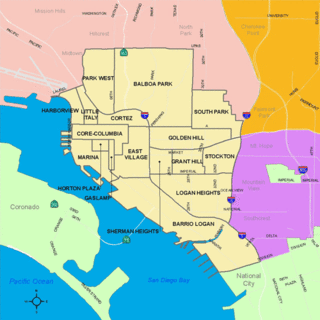
South Park is a neighborhood in San Diego, California adjacent to the southeast corner of Balboa Park. It stands out in San Diego for its tree-lined streets and walkable business district.

<span class="mw-page-title-main">Mission Hills, San Diego</span> Community in San Diego, California

<span class="mw-page-title-main">Kenwood Historic District (St. Petersburg, Florida)</span> Historic district in Florida, United States

The Kenwood Historic District is a district located in St. Petersburg, Florida U.S.A. It was designated on August 4, 2003, and is located immediately west of downtown, bounded by 9th Avenue North, 1st Avenue North, 19th Street North and 34th Street North. It contains 2,203 historic buildings. The Grand Central adjoins the district at its southern boundary.

<span class="mw-page-title-main">Glenville, Alabama</span> Unincorporated community in Alabama, United States

Glenville is an unincorporated community in Russell County, Alabama, United States which used to be in Barbour County. During the Civil War, Company "H" of the 15th Regiment Alabama Infantry was raised from Barbour and Dale counties and called the "Glenville Guards". The Glennville Historic District, containing the antebellum core of the community, is a historic district listed on the National Register of Historic Places in 1979.

<span class="mw-page-title-main">Neighborhoods of Davenport, Iowa</span>

The city of Davenport, Iowa, United States has neighborhoods dating back to the 1840s. The Davenport Plan and Zoning Commission divided the city into five areas: downtown, central, east end, near north, and northwest and west end. The neighborhoods contain many architectural designs, including Victorian, Queen Anne, and Tudor Revival. Many of the original neighborhoods were first inhabited by German settlers.

The Old Dauphin Way Historic District is a historic district in the city of Mobile, Alabama, United States. It was named for Dauphin Way, now known as Dauphin Street, which bisects the center of the district from east to west. The district is roughly bounded by Broad Street on the east, Springhill Avenue on the north, Government Street on the south, and Houston Avenue on the west. Covering 766 acres (3.10 km2) and containing 1466 contributing buildings, Old Dauphin Way is the largest historic district in Mobile.

<span class="mw-page-title-main">Quaker Hill Historic District (Waterford, Connecticut)</span> Historic district in Connecticut, United States

The Quaker Hill Historic District encompasses the center a mainly residential village in northeastern Waterford, Connecticut. Running in a mostly linear fashion along Old Norwich Road between Connecticut Route 32 and Richard Grove Road, the area first grew as a settlement of religious non-conformists in the 17th century, developed in the 19th century as a small industrial village, and became more suburban in character in the 20th century. Its architecture is reflective of these changes, and it was listed on the National Register of Historic Places in 2002.

<span class="mw-page-title-main">Squier Park, Kansas City, Missouri</span> United States historic place

Squier Park is a historic neighborhood in midtown Kansas City, Missouri, USA. It encompasses sixteen blocks bounded by Armour Boulevard on the north, 39th Street on the south, Troost Avenue on the west, and Paseo Boulevard on the east. It is primarily a residential neighborhood, with businesses along Troost Avenue. It has been listed on the National Register of Historic Places since 2012.

<span class="mw-page-title-main">Dinglewood, Columbus, Georgia</span> United States historic place

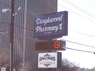
Dinglewood is a neighborhood/subdistrict located at the southern edge of Midtown Columbus, Georgia. In it is the tallest building in Columbus, the Aflac Tower. It is also home to the famous Dinglewood Pharmacy, which serves, in the opinions of the city's residents, the city's best scrambled hot dog. The boundaries of the neighborhood are generally acknowledged to be 17th Street to the north, Martin Luther King Jr. Boulevard to the south, Interstate 185 to the east and Veterans Parkway to the west. In 2007, the estimated population of the area was 1,101.

<span class="mw-page-title-main">Dinglewood House (Columbus, Georgia)</span> Historic house in Georgia, United States

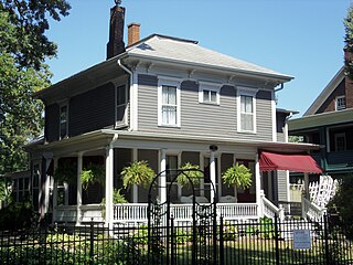
Dinglewood House is a National Register of Historic Places listed building located at 1429 Dinglewood St., Columbus, Georgia. Joel Early Hurt built the Italianate house for his wife Frances and daughter Julia in 1858 and spared no expense. Columbus architecture firm Barringer & Morton produced the drawings.

This is the list of neighborhoods in Columbus, Georgia. Neighborhoods are generally considered to be housing subdivisions of a city. In some cases, other layers of intervening organization exist that may not exist in all places. In the city of Columbus, there exist an intermediate level of organization, called districts or zones.

<span class="mw-page-title-main">Oak Lane Historic District</span> Historic district in Iowa, United States

The Oak Lane Historic District is located on the east side of Davenport, Iowa, United States. It has been listed on the National Register of Historic Places since 1984. The historic district is a residential area that stretches along Oak Lane between High Street on the north and East Locust Street on the south. There are 27 houses that make up the district. Twenty-three houses are located on Oak Lane and four are on Locust Street; the three immediately to the west of Oak Lane and one immediately to the east.

<span class="mw-page-title-main">Wingra Park Historic District</span> Historic district in Wisconsin, United States

The Wingra Park Historic District is a residential historic district on the near west side of Madison, Wisconsin, United States. The district includes 320 buildings, 297 of which are considered contributing to its historic significance, and Vilas Circle Park. It was added to the National Register of Historic Places on October 14, 1999.

<span class="mw-page-title-main">Wildwood Park Historic District (Fort Wayne, Indiana)</span> Historic district in Indiana, United States

Wildwood Park Historic District is a national historic district located at Fort Wayne, Indiana. The district encompasses 190 contributing buildings, 2 contributing sites, and 1 contributing structure in a predominantly residential section of Fort Wayne. The area was developed from about 1914 to 1955, and includes notable examples of Colonial Revival, Tudor Revival, and Bungalow / American Craftsman style residential architecture. The neighborhood was platted and designed by noted landscape architect Arthur Asahel Shurcliff.

Frederick Roy Duncan, often known as F. Roy Duncan, was an engineer and architect. His architectural practice was based in Columbus, Georgia, where he was born in 1886 and where he is buried.

<span class="mw-page-title-main">Benson Street-Forest Avenue Residential Historic District</span> Historic district in Georgia, United States

The Benson Street-Forest Avenue Residential Historic District is a historic district in Hartwell, Georgia which was listed on the National Register of Historic Places in 1986.

<span class="mw-page-title-main">East North Broadway Historic District</span> Historic district in Ohio, United States

The East North Broadway Historic District is a historic district in Clintonville, Columbus, Ohio. It was listed on the National Register of Historic Places in 2010. The linear district spans the east and north sides of East North Broadway, encompassing 117 primary and 86 secondary buildings, mostly garages and outbuildings. Most of the contributing structures are single-family houses, though there is an office building, school, and two churches. There is a diverse array of architecture styles represented, including Queen Anne, Colonial Revival, English Revival, Dutch Colonial Revival, Georgian Revival, Romanesque Revival, Craftsman, Bungalow, and mid-century modern.

<span class="mw-page-title-main">Tifton Residential Historic District</span> Historic district in Tifton, Georgia

The Tifton Residential Historic District, in Tifton, Georgia, is a historic district which was listed on the National Register of Historic Places in 2008.

References

  1. Buxton Co. http://www.buxtonco.com
  2. 1 2 MidTown, Inc. http://www.midtowncolumbusga.org/
  3. 1 2 "Historic MidTown Tour." Distributed by MidTown, Inc., Historic Columbus Foundation, and the Columbus, Georgia Visitors Bureau. December 15, 2009
  4. 1 2 3 4 5 6 7 8 9 The National Register of Historic Places http://www.nps.gov/nr/
  5. Columbus, Georgia Parks and Recreation Department http://www.columbusga.org/parks/park_sites/Lakebottom/park_lakebottom.html
  6. The Columbus Museum http://www.columbusmuseum.com/
  7. The MidTown Business Association "MidTown". Archived from the original on 2010-11-05. Retrieved 2010-06-29.