
The 2003 Atlantic hurricane season was a very active season with tropical cyclogenesis occurring before and after the official bounds of the season—the first such occurrence since the 1970 season. The season produced 21 tropical cyclones, of which 16 developed into named storms; seven of those attained hurricane status, of which three reached major hurricane status. The strongest hurricane of the season was Hurricane Isabel, which reached Category 5 status on the Saffir–Simpson hurricane scale northeast of the Lesser Antilles; Isabel later struck North Carolina as a Category 2 hurricane, causing $3.6 billion in damage and a total of 51 deaths across the Mid-Atlantic region of the United States.

The 2002 Atlantic hurricane season was a near-average Atlantic hurricane season. It officially started on June 1, 2002, and ended on November 30, dates which conventionally limit the period of each year when most tropical cyclones develop in the Atlantic Ocean. The season produced fourteen tropical cyclones, of which twelve developed into named storms; four became hurricanes, and two attained major hurricane status. While the season's first cyclone did not develop until July 14, activity quickly picked up: eight storms developed in the month of September. It ended early however, with no tropical storms forming after October 6—a rare occurrence caused partly by El Niño conditions. The most intense hurricane of the season was Hurricane Isidore with a minimum central pressure of 934 mbar, although Hurricane Lili attained higher winds and peaked at Category 4 whereas Isidore only reached Category 3. However, Lili had a minimum central pressure of 938 mbar.

The 1972 Atlantic hurricane season was a cycle of the annual tropical cyclone season in the Atlantic Ocean in the Northern Hemisphere. It was a significantly below average season, having only four fully tropical named storms, the fewest since 1930. It was one of only five Atlantic hurricane seasons since 1944 to have no major hurricanes, the others being 1968, 1986, 1994, and 2013. The season officially began on June 1, 1972 and ended on November 30, 1972. These dates, adopted by convention, historically describe the period in each year when most tropical systems form. However, storm formation is possible at any time of the year, as demonstrated in 1972 by the formation of Subtropical Storm Alpha on May 23. The season's final storm, Subtropical Storm Delta, dissipated on November 7.

A post-tropical cyclone is a former tropical cyclone that no longer possesses enough tropical qualities to be considered a tropical cyclone. The word may refer to a former tropical cyclone undergoing extratropical transition or a tropical cyclone degenerating into a remnant low. A tropical cyclone degenerating into a trough or wave, or having its low level circulation dissipate overland, lacks a cyclonic circulation and is referred as remnants instead of a post-tropical cyclone. However, post-tropical cyclones or remnants can continue producing high winds and heavy rains.
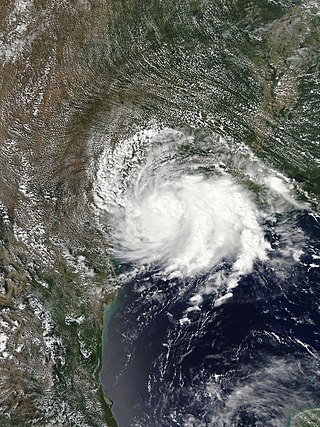
Tropical Storm Imelda was a tropical cyclone which was the fourth-wettest storm on record in the U.S. state of Texas, causing devastating and record-breaking floods in southeast Texas. The eleventh tropical cyclone and ninth named storm of the 2019 Atlantic hurricane season, Imelda formed out of an upper-level low that developed in the Gulf of Mexico and moved westward. Little development occurred until the system was near the Texas coastline, where it rapidly developed into a tropical storm before moving ashore shortly afterward on September 17. Imelda weakened after landfall, but continued bringing large amounts of flooding rain to Texas and Louisiana, before dissipating on September 21.

Hurricane Laura tied the record for the strongest hurricane to make landfall in Louisiana as measured by maximum sustained winds, along with the 1856 Last Island hurricane and Hurricane Ida, and was overall the tenth-strongest hurricane to make landfall in the United States. The thirteenth tropical cyclone, twelfth named storm, fourth hurricane, and first major hurricane of the 2020 Atlantic hurricane season, Laura originated from a large tropical wave that moved off the West African coast on August 16. The tropical wave gradually organized, becoming a tropical depression on August 20. Though in only a marginally conducive environment for intensification, the depression nevertheless intensified into a tropical storm a day later, becoming the earliest twelfth named storm on record in the North Atlantic basin, forming eight days earlier than 1995's Hurricane Luis. The depression received the name Laura and tracked west-northwest towards the Lesser Antilles.

Hurricane Sally was a destructive and slow-moving Atlantic hurricane that was the first hurricane to make landfall in the U.S. state of Alabama since Ivan in 2004, coincidentally on the same date in the same place. The eighteenth named storm and seventh hurricane of the extremely active 2020 Atlantic hurricane season, Sally developed from an area of disturbed weather which was first monitored over the Bahamas on September 10. The system grew a broad area of low-pressure on September 11, and was designated as a tropical depression late that day. Early the next day, the depression made landfall at Key Biscayne and subsequently strengthened into Tropical Storm Sally that afternoon. Moderate northwesterly shear prevented significant intensification for the first two days, but convection continued to grow towards the center and Sally slowly intensified. On September 14, a center reformation into the center of the convection occurred, and data from a hurricane hunter reconnaissance aircraft showed that Sally had rapidly intensified into a strong Category 1 hurricane. However, an increase in wind shear and upwelling of colder waters halted the intensification and Sally weakened slightly on September 15 before turning slowly northeastward. Despite this increase in wind shear, it unexpectedly re-intensified, reaching Category 2 status early on September 16 before making landfall at peak intensity at 09:45 UTC on September 16, near Gulf Shores, Alabama, with maximum sustained winds of 110 mph (180 km/h) and a minimum central pressure of 965 millibars (28.5 inHg). The storm rapidly weakened after landfall before transitioning into an extratropical low at 12:00 UTC the next day. Sally's remnants lasted for another day as they moved off the coast of the Southeastern United States before being absorbed into another extratropical storm on September 18.

Hurricane Paulette was a strong and long-lived Category 2 Atlantic hurricane which became the first to make landfall in Bermuda since Hurricane Gonzalo in 2014, and was the longest-lasting tropical cyclone of 2020 globally. The sixteenth named storm and sixth hurricane of the record-breaking 2020 Atlantic hurricane season, Paulette developed from a tropical wave that left the coast of Africa on September 2. The wave eventually consolidated into a tropical depression on September 7. Paulette fluctuated in intensity over the next few days, due to strong wind shear, initially peaking as a strong tropical storm on September 8. It eventually strengthened into a hurricane early on September 13 as shear decreased. On September 14, Paulette made landfall in northeastern Bermuda as a Category 2 hurricane, while making a gradual turn to the northeast. The cyclone further strengthened as it moved away from the island, reaching its peak intensity with 1-minute sustained winds of 105 mph (169 km/h) and a minimum central atmospheric pressure of 965 mbar (28.5 inHg) on September 14. On the evening of September 15, Paulette began to weaken and undergo extratropical transition, which it completed on September 16. The hurricane's extratropical remnants persisted and moved southward then eastward, and eventually, Paulette regenerated into a tropical storm early on September 20 south of the Azores– which resulted in the U.S National Weather Service coining the phrase "zombie storm" to describe its unusual regeneration. Paulette's second phase proved short-lived, however, as the storm quickly weakened and became post-tropical again two days later. The remnant persisted for several days before dissipating south of the Azores on September 28. In total, Paulette was a tropical cyclone for 11.25 days, and the system had an overall lifespan of 21 days.

Subtropical Storm Alpha was the first subtropical or tropical cyclone ever observed to make landfall in mainland Portugal. The twenty-second tropical or subtropical cyclone and twenty-first named storm of the extremely active and record-breaking 2020 Atlantic hurricane season, Alpha originated from a large non-tropical low that was first monitored by the National Hurricane Center on 15 September. Initially not anticipated to transition into a tropical cyclone, the low gradually tracked south-southeastward for several days with little development. By early on 17 September, the low had separated from its frontal features and exhibited sufficient organization to be classified as a subtropical cyclone, as it approached the Iberian Peninsula, becoming a subtropical storm around that time. Alpha then made landfall just south of Figueira da Foz, Portugal during the evening of 18 September, then rapidly weakened as it moved over the mountainous terrain of Northeastern Portugal. The system degenerated into a remnant low on 19 September, when it was last noted.

Tropical Storm Fred was a strong tropical storm which affected much of the Greater Antilles and the Southeastern United States in August 2021. The sixth tropical storm of the 2021 Atlantic hurricane season, Fred originated from a tropical wave first noted by the National Hurricane Center on August 4. As the wave drifted westward, advisories were initiated on the wave as a potential tropical cyclone by August 9 as it was approaching the Leeward Islands. Entering the Eastern Caribbean Sea after a close pass to Dominica by the next day, the potential tropical cyclone continued northwestward. By August 11, the disturbance had formed into Tropical Storm Fred just south of Puerto Rico, shortly before hitting the Dominican Republic on the island of Hispaniola later that day. The storm proceeded to weaken to a tropical depression over the highly mountainous island, before emerging north of the Windward Passage on August 12. The disorganized tropical depression turned to the west and made a second landfall in Northern Cuba on August 13. After having its circulation continuously disrupted by land interaction and wind shear, the storm degenerated into a tropical wave as it was turning northward near the western tip of Cuba the following day. Continuing north, the remnants of Fred quickly re-organized over the Gulf of Mexico, regenerating into a tropical storm by August 15. Fred continued towards the Florida Panhandle and swiftly intensified to a strong 65 mph (105 km/h) tropical storm before making landfall late on August 16 and moving into the state of Georgia. Afterward, Fred continued moving north-northeastward, before degenerating into an extratropical low on August 18. Fred's remnants later turned eastward, and the storm's remnants dissipated on August 20, near the coast of Massachusetts.
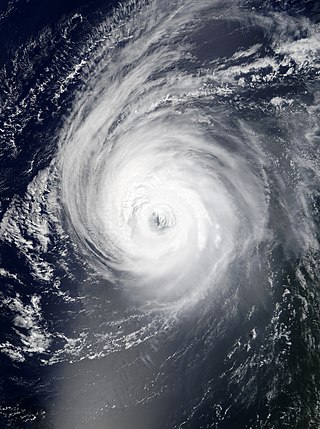
Hurricane Larry was a strong and long-lived Cape Verde hurricane that became the first hurricane to make landfall in Newfoundland since Igor in 2010. The twelfth named storm, fifth hurricane, and third major hurricane of the 2021 Atlantic hurricane season, Larry originated from a tropical wave that emerged off the coast of Africa and organized into a tropical depression on August 31. The next day, the depression developed into a tropical storm, receiving the name Larry. The storm moved quickly across the far eastern tropical Atlantic, where it strengthened into a Category 1 hurricane the morning of September 2. Then, after undergoing a period of rapid intensification, Larry became a major Category 3 hurricane early on September 4. After churning for several days as a strong hurricane in the open ocean, Larry made landfall in Newfoundland on September 11, as a Category 1 hurricane. Later that day, Larry became an extratropical cyclone. Finally, on September 13, Larry was absorbed by a larger extratropical cyclone near Greenland.

Hurricane Nicholas was a slow-moving and erratic Category 1 hurricane that made landfall in the U.S. state of Texas in mid-September 2021. The fourteenth named storm and sixth hurricane of the 2021 Atlantic hurricane season, Nicholas originated from a tropical wave that emerged off the west coast of Africa on August 28. The system developed into a tropical storm on September 12, with the National Hurricane Center (NHC) naming the cyclone Nicholas. Nicholas gradually intensified initially, due to adverse effects of strong wind shear. However, late on September 13, Nicholas began intensifying at a faster rate, and at 03:00 UTC on September 14, Nicholas intensified into a Category 1 hurricane, with maximum sustained winds of 75 mph (121 km/h) and a minimum central pressure of 988 mbar (29.2 inHg). At 5:30 UTC on the same day, Nicholas made landfall in Texas at peak intensity. Afterward, the system gradually weakened, weakening into a tropical storm several hours later, and weakening further into a tropical depression on the next day. The system proceeded to drift slowly over Louisiana. On September 15, Nicholas degenerated into a remnant low, before being absorbed into another extratropical system on September 20.


