Local government in Wales is primarily undertaken by the twenty-two principal councils. The councils are unitary authorities, meaning they are responsible for providing local government services within their principal area, including education, social work, environmental protection, and most highway maintenance. The principal areas are divided into communities, most of which have an elected community council. The services provided by community councils vary, but they will typically maintain public spaces and facilities. Local councils in Wales are elected; the most recent local elections in Wales took place in 2022, and the next are due to take place in 2027.

Rhondda Cynon Taf is a county borough in the south-east of Wales. It consists of five valleys: the Rhondda Fawr, Rhondda Fach, Cynon, Taff and Ely valleys, plus a number of towns and villages away from the valleys.

The preserved counties of Wales are the eight current areas used in Wales for the ceremonial purposes of lieutenancy and shrievalty. They are based on the counties which were used for local government and other purposes between 1974 and 1996. Each comprises one or more of the 22 single-tier principal areas which are used for administrative purposes.
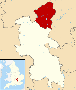
The City of Milton Keynes is a unitary authority area with both borough and city status, in Buckinghamshire. It is the northernmost district of the South East England Region. The borough abuts Bedfordshire, Northamptonshire and the remainder of Buckinghamshire.
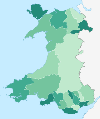
The principal areas of Wales, comprising the counties andcounty boroughs of Wales, are a form of subdivision in Wales. There are currently 22 principal areas in Wales, and they were established in 1996.

Wrexham County Borough is a county borough, with city status, in the north-east of Wales. It borders the English ceremonial counties of Cheshire and Shropshire to the east and south-east respectively, Powys to the south-west, Denbighshire to the west and Flintshire to the north-west. The city of Wrexham is the administrative centre. The county borough is part of the preserved county of Clwyd.

North Wales is a region of Wales, encompassing its northernmost areas. It borders mid Wales to the south, England to the east, and the Irish Sea to the north and west. The area is highly mountainous and rural, with Snowdonia National Park and the Clwydian Range and Dee Valley, known for its mountains, waterfalls and trails, wholly within the region. Its population is concentrated in the north-east and northern coastal areas, with significant Welsh-speaking populations in its western and rural areas. North Wales is imprecisely defined, lacking any exact definition or administrative structure. It is commonly defined administratively as its six most northern principal areas, but other definitions exist, with Montgomeryshire historically considered to be part of the region.

Alyn and Deeside was one of six local government districts in the county of Clwyd, north-east Wales from 1974 to 1996. There is still a parliamentary constituency of the same name.

The Borough of Arfon was local government district with borough status from 1974 to 1996, being one of five districts in the county of Gwynedd, north-west Wales.

Fishbourne is a village between Wootton and Ryde, on the Isle of Wight.

The District of Montgomeryshire or Montgomery was one of three local government districts of the county of Powys, Wales, from 1974 until 1996. The district had an identical area to the previous administrative county of Montgomeryshire. The district was abolished in 1996, with Powys County Council taking over its functions.

Gwynedd Council, which calls itself by its Welsh name Cyngor Gwynedd, is the governing body for the county of Gwynedd, one of the principal areas of Wales. The council administrates internally using the Welsh language.

Cheshire West and Chester is a local government district with borough status in Cheshire, England. It was established on 1 April 2009 as part of the 2009 local government changes, by virtue of an order under the Local Government and Public Involvement in Health Act 2007. It superseded the boroughs of Ellesmere Port and Neston, Vale Royal and the City of Chester; its council is a unitary authority, having also assumed the functions and responsibilities of the former Cheshire County Council within its area. The remainder of ceremonial Cheshire is composed of Cheshire East, Halton and Warrington. Cheshire West and Chester has three key urban areas: Chester, Ellesmere Port and Northwich/Winsford.

A census of the population of the United Kingdom is taken every ten years. The 2011 census was held in all counties of the UK on 27 March 2011. It was the first UK census which could be completed online via the Internet. The Office for National Statistics (ONS) is responsible for the census in England and Wales, the General Register Office for Scotland (GROS) is responsible for the census in Scotland, and the Northern Ireland Statistics and Research Agency (NISRA) is responsible for the census in Northern Ireland.

Merthyr Tydfil County Borough is located in the historic county of Glamorgan in Wales and takes its name from its largest town. The county borough covers an area of 111 km2 (43 sq mi) and had a population of approximately 58,900 in 2021.

Rhondda Cynon Taf is a county borough in South Wales. It is located to the north-west of Cardiff and covers an area of 424 km2 (164 sq mi). In 2021 the population was approximately 237,500.

Deborah Ann Wilcox, Baroness Wilcox of Newport is a British politician serving as a Member of the House of Lords since 2019. A member of the Labour Party, she served as Leader of the Welsh Local Government Association from 2017 to 2019. Wilcox was Leader of Newport City Council from 2016 to 2019 and served on the Council from 2004 to 2022.

Romani people have been recorded in the United Kingdom since at least the early 16th century. Records of Romani people in Scotland date to the early 16th century. Romani number around est. 225,000 in the UK. This includes the sizable population of Eastern European Roma, who immigrated into the UK in the late 1990s/early 2000s, and also after EU expansion in 2004. Romani people in the UK are considered part of the Gypsy, Roma and Traveller (GRT) community. Romani people in the UK are predominantly Christian, with 71.8% of English and Welsh Romanies identifying as Christian in the 2021 census compared to 46.2% of the wider population.
