List of airports in Antarctica

Last updated

This is an alphabetical list of airports in Antarctica , including airstrips, heliports and skiways (snow runways [1] ).

Contents

List


Airport name
Type

Country

ICAO
code

IATA
code

Other
code

Location

Coordinates
Runway(s):
Direction
Length
Surface
Arctowski Heliport [2] Flag of Poland.svg  Poland AG11177 King George Island 62°09′34″S58°28′23″W / 62.15941°S 58.47293°W / -62.15941; -58.47293 Concrete
Belgrano II Skiway [3] Flag of Argentina.svg  Argentina SAYB Bertrab Nunatak 64°58′32″S60°04′17″W / 64.975659°S 60.071501°W / -64.975659; -60.071501 6,560 feet (2,000 m)
Ice
Bharati Heliport Flag of India.svg  India Larsemann Hills 69°24′24″S76°11′36″E / 69.406770°S 76.193429°E / -69.406770; 76.193429 Concrete
Boulder Clay Runway [4] [5]
(serving Zucchelli)
Flag of Italy.svg  Italy AQBC [6] Terra Nova Bay 74°44′24″S164°02′14″E / 74.740059°S 164.037335°E / -74.740059; 164.037335 02/20
7,218 feet (2,200 m)

Gravel
Browning Pass Skiway [7] Flag of Italy.svg  Italy AT02 Terra Nova Bay 74°37′21″S163°54′58″E / 74.622563°S 163.916242°E / -74.622563; 163.916242 02/20
3,010 feet (920 m)

Ice
Byrd Surface SkiwayFlag of the United States (23px).png  United States Marie Byrd Land 80°01′01″S119°35′06″W / 80.016933°S 119.584944°W / -80.016933; -119.584944 10,940 feet (3,330 m)
Ice
Carlini Airstrip [8] Flag of Argentina.svg  Argentina SAYJ Potter Cove 62°14′18″S58°40′00″W / 62.2383003°S 58.666599°W / -62.2383003; -58.666599 1,312 feet (400 m)
Gravel
Casey Station Skiway
(serving Casey)
Flag of Australia (converted).svg  Australia YCSK Budd Coast
Wilkes Land
66°17′17″S110°45′27″E / 66.288015°S 110.757578°E / -66.288015; 110.757578 9/27
6,547 feet (1,996 m)
Ice
Concordia Skiway [9] Flag of France.svg  France
Flag of Italy.svg  Italy
AT03 Antarctic Plateau 75°06′12″S123°21′30″E / 75.103278°S 123.358250°E / -75.103278; 123.358250 01/19
6,560 feet (2,000 m)

Ice
D10 Skiway
(serving Dumont d'Urville Station) [10]
Flag of France.svg  France AT04 Cape Géodésie 66°40′05″S139°49′11″E / 66.668000°S 139.819667°E / -66.668000; 139.819667 10/28
4,265 feet (1,300 m)

Ice
D85 Skiway [11] Flag of France.svg  France AT05 Adélie Land 70°25′30″S134°08′45″E / 70.425°S 134.145833°E / -70.425; 134.145833 9/27
9,345 feet (2,848 m)

Ice
Davis Plateau Skiway [12]
(serving Davis)
Flag of Australia (converted).svg  Australia QAD [13] AT07 Princess Elizabeth Land 68°28′11″S78°47′27″E / 68.469639°S 78.790889°E / -68.469639; 78.790889 17/35
317 feet (97 m)

Ice
Davis Sea Ice Skiway
(serving Davis)
Flag of Australia (converted).svg  Australia Princess Elizabeth Land 68°33′53″S77°57′54″E / 68.564667°S 77.964972°E / -68.564667; 77.964972 317 feet (97 m)
Ice
Dome Fuji Skiway Flag of Japan.svg  Japan Queen Maud Land 77°19′00″S39°42′00″E / 77.316667°S 39.700000°E / -77.316667; 39.700000 3,937 feet (1,200 m)
Ice
Drúzhnaya 4  [ ru ] SkiwayFlag of Russia.svg  Russia Princess Elizabeth Land 69°44′16″S73°44′00″E / 69.737894°S 73.733342°E / -69.737894; 73.733342 6,562 feet (2,000 m)
Ice
Enigma Lake Skiway [14]
(serving Mario Zucchelli)
Flag of Italy.svg  Italy AT09 Terra Nova Bay 74°43′08″S164°01′46″E / 74.718921°S 164.029558°E / -74.718921; 164.029558 18/36
2,376 feet (724 m)

Ice
Esperanza Airstrip [15] Flag of Argentina.svg  Argentina SAYE King George Island 63°24′00″S56°59′00″W / 63.400002°S 56.983299°W / -63.400002; -56.983299 1,640 feet (500 m)
Gravel
Ferraz Heliport [16] Flag of Brazil.svg  Brazil AG11178 King George Island 62°05′09″S58°23′29″W / 62.0857°S 58.3915°W / -62.0857; -58.3915 6,560 feet (2,000 m)
Fossil Bluff Skiway [17] Flag of the United Kingdom.svg  United Kingdom AT10 George VI Sound 71°19′46″S68°16′01″W / 71.329333°S 68.267°W / -71.329333; -68.267 17/35
3,960 feet (1,210 m)

Snow
Halley Skiway [18] Flag of the United Kingdom.svg  United Kingdom EGAHAT11 Brunt Ice Shelf 75°34′54″S26°32′28″W / 75.581667°S 26.541167°W / -75.581667; -26.541167 09/27
1,191 feet (363 m)

Snow
Jack F. Paulus Skiway [19]
(serving Amundsen–Scott South Pole Station)
Flag of the United States (23px).png  United States NZSP South Pole 89°59′51″S139°16′22″E / 89.9975°S 139.272778°E / -89.9975; 139.272778 02/20
12,000 feet (3,700 m)
Snow
Kohnen Skiway [20] Flag of Germany.svg  Germany AT12 Queen Maud Land 75°00′07″S0°04′00″E / 75.001912°S 0.066620°E / -75.001912; 0.066620 17/35
6,560 feet (2,000 m)

Ice
Kunlun SkiwayFlag of the People's Republic of China.svg  China East Antarctica 80°25′02″S77°06′58″E / 80.417139°S 77.116111°E / -80.417139; 77.116111 10,236 feet (3,120 m)
Ice
Machu Picchu Heliport [21] Flag of Peru.svg  Peru AG11179 King George Island 62°05′28″S58°28′16″W / 62.091230°S 58.471047°W / -62.091230; -58.471047 Concrete
Maitri HelipadFlag of India.svg  India Schirmacher Oasis 70°46′00″S11°43′55″E / 70.766667°S 11.731944°E / -70.766667; 11.731944 Concrete
Marambio Airport [22] Flag of Argentina.svg  Argentina SAWBQAB [23] Seymour Island 64°14′21″S56°37′48″W / 64.239205°S 56.630074°W / -64.239205; -56.630074 05/23
4,134 feet (1,260 m)

Gravel
Marble Point Heliport [24]
Refuelling station
Flag of the United States (23px).png  United States GC0079 Victoria Land 77°24′47″S163°40′44″E / 77.413055°S 163.678889°E / -77.413055; 163.678889 Gravel
Matienzo Skiway [25] Flag of Argentina.svg  Argentina SAWZBTM Larsen Nunatak 64°58′32″S60°04′17″W / 64.975659°S 60.071501°W / -64.975659; -60.071501 4,920 feet (1,500 m)
Sea Ice
Mawson Plateau Skiway [26] Flag of Australia (converted).svg  Australia Mac. Robertson Land 67°43′09″S62°49′26″E / 67.719133°S 62.82395°E / -67.719133; 62.82395 Variable
Ice
Mawson Sea Ice Skiway [26] Flag of Australia (converted).svg  Australia Mac. Robertson Land 67°36′03″S62°49′58″E / 67.600833°S 62.832783°E / -67.600833; 62.832783 Variable
Sea Ice
McMurdo Ice Runway [27]
(serving McMurdo Station and Scott Base)
Flag of the United States (23px).png  United States
Flag of New Zealand.svg  New Zealand
NZIRQAI Ross Island 77°51′14″S166°28′07″E / 77.853889°S 166.468611°E / -77.853889; 166.468611 11/29
9,979 feet (3,042 m)
Ice
16/34
9,979 feet (3,042 m)
Ice
Mid Point Skiway [28] Flag of Italy.svg  Italy AT14 East Antarctic Ice Sheet 75°32′28″S145°49′18″E / 75.541095°S 145.821672°E / -75.541095; 145.821672 01/19
3,960 feet (1,210 m)

Ice
Molodezhnaya Ice Runway [29] Flag of Russia.svg  Russia AT15 Thala Hills 67°40′58″S46°08′05″E / 67.682833°S 46.134667°E / -67.682833; 46.134667 10/28
8,395 feet (2,559 m)

Ice
Neumayer III Skiway [30] Flag of Germany.svg  Germany QAN [31] AT16 Ekstrom Ice Shelf 70°38′07″S8°15′49″W / 70.635205°S 8.263539°W / -70.635205; -8.263539 15/33
3,326 feet (1,014 m)

Ice
Novo Runway
(serving Novolazarevskaya and Maitri)
Flag of Russia.svg  Russia
Flag of India.svg  India
QAO [32] AT17 Queen Maud Land 70°49′17″S11°38′36″E / 70.821517°S 11.643345°E / -70.821517; 11.643345 10/28
10,824 feet (3,299 m)

Blue Ice
O'Higgins Skiway
(serving General Bernardo O'Higgins)
Flag of Chile.svg  Chile SCBO Prime Head 63°20′34″S57°49′23″W / 63.342759°S 57.823152°W / -63.342759; -57.823152 2,625 feet (800 m)
Ice
Odell Glacier Skiway [33] Flag of the United States (23px).png  United States AT18 Odell Glacier 76°39′00″S159°58′00″E / 76.65°S 159.966667°E / -76.65; 159.966667 }18/36
5,914 feet (1,803 m)

Ice
Orcadas Heliport [34] Flag of Argentina.svg  Argentina SAYO Laurie Island 60°44′17″S44°44′16″W / 60.737963°S 44.737891°W / -60.737963; -44.737891
Palmer Skiway [35]
Flag of the United States (23px).png  United States NZ12NZ0B
AG11180
Anvers Island 64°46′28″S64°02′09″W / 64.774582°S 64.035907°W / -64.774582; -64.035907 01/19
2,500 feet (760 m)
Snow
Patriot Hills Blue-Ice Runway Flag of the United States (23px).png  United States SCPZ Ellsworth Mountains 80°18′53″S81°22′29″W / 80.314861°S 81.374833°W / -80.314861; -81.374833 24M
3,281 feet (1,000 m)
Ice
Pegasus Field [36]
(serving McMurdo Station and Scott Base)
Flag of the United States (23px).png  United States
Flag of New Zealand.svg  New Zealand
NZPG Ross Island 77°58′28″S166°31′40″E / 77.974528°S 166.527861°E / -77.974528; 166.527861 15/33
10,000 feet (3,000 m)
Ice
08/26
10,000 feet (3,000 m)
Ice (skiway) [37]
Perseus Airstrip
(serving Princess Elisabeth Antarctica)
Flag of Belgium (civil).svg  Belgium Queen Maud Land 71°25′42″S23°33′57″E / 71.428333°S 23.565833°E / -71.428333; 23.565833 10/28
9,840 feet (3,000 m)
Blue Ice
Petrel Skiway [38] Flag of Argentina.svg  Argentina SA47 Dundee Island 63°28′44″S56°13′53″W / 63.478971°S 56.231277°W / -63.478971; -56.231277 08/26
3,485 feet (1,062 m)

Ice
Phoenix Airfield [39]
(serving McMurdo Station and Scott Base)
Flag of the United States (23px).png  United States
Flag of New Zealand.svg  New Zealand
NZFXQAX [40] Ross Island 77°57′23″S166°46′00″E / 77.956271°S 166.766750°E / -77.956271; 166.766750 15/33
11,000 feet (3,400 m)
Compacted Snow
Plateau Station Skiway [41] Flag of the United States (23px).png  United States AT20 Queen Maud Land 79°15′03″S40°33′38″E / 79.250806°S 40.560417°E / -79.250806; 40.560417 18/36
11,458 feet (3,492 m)

Ice
Plog Island Skiway
(serving Davis)
Flag of Australia (converted).svg  Australia Plog Island 68°32′04″S78°00′22″E / 68.534307°S 78.006152°E / -68.534307; 78.006152 (variable)
Ice
Primavera Heliport Flag of Argentina.svg  Argentina Cierva Cove 64°09′24″S60°57′12″W / 64.156597°S 60.953444°W / -64.156597; -60.953444 Concrete
Princess Elisabeth Skiway Flag of Belgium (civil).svg  Belgium QAP [42] AT99 Utsteinen Nunatak 71°57′27″S23°13′12″E / 71.957375°S 23.220126°E / -71.957375; 23.220126 4,650 feet (1,420 m)
Blue Ice
Progress Skiway Flag of Russia.svg  Russia Larsemann Hills 69°25′51″S76°19′55″E / 69.430723°S 76.331940°E / -69.430723; 76.331940 4,920 feet (1,500 m)
Ice
Rodolfo Marsh Martin Airport
(serving Eduardo Frei)
Flag of Chile.svg  Chile SCRMTNM King George Island 62°11′27″S58°59′12″W / 62.190833°S 58.986667°W / -62.190833; -58.986667 11/29
4,232 feet (1,290 m)
Gravel
Rothera Air Facility [43] Flag of the United Kingdom.svg  United Kingdom EGARQAR [44] AT01 Rothera Point
Adelaide Island
67°34′04″S68°07′39″W / 67.567778°S 68.127389°W / -67.567778; -68.127389 18/36
2,851 feet (869 m)
Gravel
Rumdoodle Skiway
(serving Mawson)
Flag of Australia (converted).svg  Australia AT21 Mac. Robertson Land 67°45′13″S62°45′58″E / 67.753711°S 62.766122°E / -67.753711; 62.766122 17/35
1,320 feet (400 m)
Ice
S17 SkiwayFlag of Japan.svg  Japan Enderby Land 69°01′41″S40°05′33″E / 69.02807608°S 40.09244947°E / -69.02807608; 40.09244947 4,000 feet (1,200 m)
Ice
San Martín Airstrip [45] Flag of Argentina.svg  Argentina SAYSBSM Marguerite Bay 68°07′00″S67°06′00″W / 68.116699°S 67.099998°W / -68.116699; -67.099998 1,640 feet (500 m)
Ice
SANAE IV Skiway [46] Flag of South Africa.svg  South Africa
QAS [47] AT22 Queen Maud Land 71°40′21″S2°49′29″W / 71.672384°S 2.824855°W / -71.672384; -2.824855 17/35
3,274 feet (998 m)

Ice
Showa Skiway [48] Flag of Japan.svg  Japan AT25 East Ongul Island 69°01′11″S39°37′31″E / 69.019823°S 39.625359°E / -69.019823; 39.625359 17/35
4,000 feet (1,200 m)

Ice
Siple Dome Skiway Flag of the United States (23px).png  United States Marie Byrd Land 81°39′29″S148°59′51″E / 81.658053°S 148.997391°E / -81.658053; 148.997391 10,940 feet (3,330 m)
Ice
Sitry Skiway [49] Flag of Italy.svg  Italy AT23 Antarctic Plateau 71°39′14″S148°39′12″E / 71.653889°S 148.653333°E / -71.653889; 148.653333 17/35
3,274 feet (998 m)

Ice
Sky Blu Skiway [50] Flag of the United Kingdom.svg  United Kingdom EGATAT24 Ellsworth Land 74°51′23″S71°34′10″W / 74.856333°S 71.569333°W / -74.856333; -71.569333 14/32
3,960 feet (1,210 m)

Blue Ice
St. Kliment Ohridski Heliport Flag of Bulgaria.svg  Bulgaria Livingston Island 62°38′27″S60°21′53″W / 62.6409284°S 60.3646792°W / -62.6409284; -60.3646792 Concrete
Taishan SkiwayFlag of the People's Republic of China.svg  China Princess Elizabeth Land 73°51′50″S76°58′27″E / 73.863889°S 76.974167°E / -73.863889; 76.974167 6,955 feet (2,120 m)
Ice
Thiel Skiway [51] AT26 Thiel Mountains 85°11′54″S87°52′42″W / 85.198333°S 87.878333°W / -85.198333; -87.878333 17/35
5,175 feet (1,577 m)
[52]
Ice
Troll Airfield [53]
(serving Troll Station)
Flag of Norway.svg  Norway ENOE [54] QAT [54] AT27 Queen Maud Land 71°57′19″S2°28′03″E / 71.955389°S 2.467397°E / -71.955389; 2.467397 11/29
10,826 feet (3,300 m)

Blue ice
Union Glacier Blue-Ice Runway
(serving Union Glacier Camp and Union Glacier Station)
Flag of the United States (23px).png  United States
Flag of Chile.svg  Chile
SCGCUGL Heritage Range 79°46′40″S83°19′15″W / 79.777778°S 83.320833°W / -79.777778; -83.320833 18/36
9,842 feet (3,000 m)
Blue ice
Vostok Skiway [55] Flag of Russia.svg  Russia AT28 Pole of Cold 78°27′58″S106°50′54″E / 78.466139°S 106.84825°E / -78.466139; 106.84825 03/21
11,983 feet (3,652 m)

Ice
Wilkins Runway [56]
(serving Casey)
Flag of Australia (converted).svg  Australia YWKS Budd Coast
Wilkes Land
(Upper Peterson Glacier)
66°41′22″S111°29′09″E / 66.689443°S 111.485833°E / -66.689443; 111.485833 09/27
13,123 feet (4,000 m)
Ice
Williams Field [57]
(serving McMurdo Station and Scott Base)
Flag of the United States (23px).png  United States
Flag of New Zealand.svg  New Zealand
NZWDQAW [58] Ross Island 77°52′02″S167°03′24″E / 77.867357°S 167.056572°E / -77.867357; 167.056572 07/25
10,000 feet (3,000 m)
Snow
15/33
10,000 feet (3,000 m)
Snow
Wolfs Fang Runway Flag of the United Kingdom.svg  United Kingdom WFR [59] AT98 Queen Maud Land 71°31′S08°48′E / 71.517°S 8.800°E / -71.517; 8.800 2,500 metres (8,200 ft)
Blue Ice
Zhongshan Station Flag of the People's Republic of China.svg  China Larsemann Hills 69°25′47″S76°20′31″E / 69.429673°S 76.341892°E / -69.429673; 76.341892 Ice
Zucchelli Ice Runway
(serving Zucchelli) [60]
Flag of Italy.svg  Italy NZTB [61] AT13 Terra Nova Bay 74°40′59″S164°06′45″E / 74.682975°S 164.112594°E / -74.682975; 164.112594 03/21
10,137 feet (3,090 m)

Ice

See also

Related Research Articles

<span class="mw-page-title-main">Dumont d'Urville Station</span> Administrative centre and Antarctic base in Archipelago of Pointe-Géologie, France

The Dumont d'Urville Station is a French scientific station in Antarctica on Île des Pétrels, archipelago of Pointe-Géologie in Adélie Land. It is named after explorer Jules Dumont d'Urville, whose expedition landed on Débarquement Rock in the Dumoulin Islands at the northeast end of the archipelago on January 21, 1840. It is operated by the "French Polar Institute Paul-Émile Victor", a joint operation of French public and para-public agencies. It is the administrative centre of Adélie Land.

<span class="mw-page-title-main">Showa Station (Antarctica)</span> Antarctic base

Showa Station, sometimes alternately spelled Syowa Station, is a Japanese permanent research station on East Ongul Island in Queen Maud Land, Antarctica. Built in 1957, Showa Station is named for the era in the Japanese calendar during which it was established, the Shōwa period.

<span class="mw-page-title-main">Williams Field</span> Airstrip in Antarctica

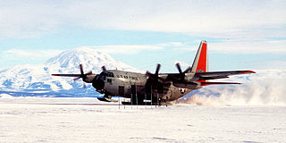
Williams Field or Willy Field is a United States Antarctic Program airfield in Antarctica. Williams Field consists of two snow runways located on approximately 8 meters (25 ft) of compacted snow, lying on top of 8–10 ft of ice, floating over 550 meters (1,800 ft) of water. The airport, which is approximately seven miles from Ross Island, serves McMurdo Station and New Zealand's Scott Base. Until the 2009–10 summer season, Williams was the major airfield for on-continent aircraft operations in Antarctica.

<span class="mw-page-title-main">Novolazarevskaya Station</span> Antarctic station

Novolazarevskaya Station is a Russian, formerly Soviet, Antarctic research station. The station is located at Schirmacher Oasis, Queen Maud Land, 75 km (47 mi) from the Antarctic coast, from which it is separated by Lazarev Ice Shelf. It was opened on January 18, 1961 by the 6th Soviet Antarctic Expedition. The maximum summer population is 70.

<span class="mw-page-title-main">Fossil Bluff</span> Antarctic base

Fossil Bluff is a seasonal British aircraft refuelling station located on the east coast of Alexander Island in Antarctica. In operation since 1961, its facilities provide fuel, storage, and ancillary support for British exploration and operations during the summer season, October through March. The site is adjacent to a natural, north–south travelling route along the George VI Ice Shelf.

<span class="mw-page-title-main">Sky Blu</span> Logistics and air facility in United Kingdom

Sky Blu is a forward operating station for the British Antarctic Survey located in southern Palmer Land, Antarctica. It is in an area of blue ice, an extremely hard and dense ice which has lost the air bubbles that normally cloud the ice. It provides a runway able to accommodate wheeled aircraft that are larger than can be handled by other types of runways in the area.

<span class="mw-page-title-main">Pegasus Field</span> Airport in Ross Island, Antarctica

Pegasus Field was an airstrip in Antarctica, the southernmost of three airfields serving McMurdo Station. It closed due to excessive melting in the summer season caused by warmer temperatures combined with dust and dirt blown in from nearby Black Island. The last flight was on December 8, 2016 and it was replaced by Phoenix Airfield with flights starting in February 2017.

<span class="mw-page-title-main">Ice Runway</span> Sea ice airport for McMurdo Station, Antarctica

The Ice Runway is the principal runway for the U.S. Antarctic Program during the summer Antarctic field season due to its proximity to McMurdo Station. The other two runways in the area are the snow runway at Williams Field (NZWD) and the compacted snow runway at Phoenix Airfield (NZFX), which replaced Pegasus Field (NZPG) in 2017.

<span class="mw-page-title-main">Troll Airfield</span> Airstrip in Queen Maud Land, Antarctica

Troll Airfield is an airstrip located 6.8 kilometres (4.2 mi) from the research station Troll in Princess Martha Coast in Queen Maud Land, Antarctica. Owned and operated by the Norwegian Polar Institute, it consists of a 3,300-by-100-metre runway on glacial blue ice on the Antarctic ice sheet. The airport is located at 1,232 metres (4,042 ft) above mean sea level and is 235 kilometres (146 mi) from the coast.

<span class="mw-page-title-main">Zucchelli Station</span> Antarctic base

Zucchelli Station is an Italian seasonal research station in Antarctica, located at Terra Nova Bay on a granitic headland along the coast of the Northern Foothills to the north-east of Gerlache Inlet. It has been named after Mario Zucchelli, director of the activities, which conducted for sixteen years, for the ENEA-Unità Tecnica Antartide as part of the National Antarctic Research Program (PNRA).

<span class="mw-page-title-main">Progress Station</span> Antarctic station

Progress is a Russian research station in Antarctica. It is located at the Larsemann Hills antarctic oasis on the shore of Prydz Bay.

<span class="mw-page-title-main">Hanchey Army Heliport</span> United States Army heliport

Hanchey Army Heliport is a military heliport serving Fort Novosel in Dale County, Alabama, United States. Owned by the United States Army, it is located 6 NM (11 km) south of the city of Ozark.

<span class="mw-page-title-main">Rumdoodle Peak</span> Airport near Mawson Station, Antarctica

Rumdoodle Peak, elevation 875 m ASL, is a small but prominent mountain in the north-western part of the North Masson Range of the Framnes Mountains in Antarctica, near Mawson Station.

Lowe Army Heliport is a military heliport serving Fort Novosel in Dale County, Alabama, United States. Owned by the United States Army, it is located 8 nautical miles (15 km) southwest of the city of Ozark.

<span class="mw-page-title-main">Kohnen Station</span> Antarctic base

Kohnen-Station is a German summer-only polar research station in the Antarctic, able to accommodate up to 28 people. It is named after the geophysicist Heinz Kohnen (1938–1997), who was for a long time the head of logistics at the Alfred Wegener Institute.

<span class="mw-page-title-main">Phoenix Airfield</span> Airport in Ross Island, Antarctica

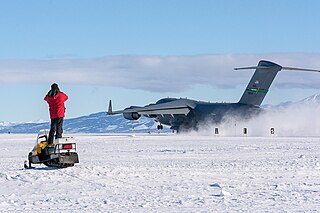
Phoenix Airfield is an airstrip in Antarctica opened in early 2017, designed to replace the Pegasus Field's role in serving McMurdo Station.

<span class="mw-page-title-main">Rittenhouse Army Heliport</span> Heliport in Pinal County, Arizona

Rittenhouse Army Heliport formally Williams Field Auxiliary No. 2 is an Arizona Army National Guard training airstrip 11.5 miles east of the central business district of Queen Creek, a city in Pinal County, Arizona, United States and 31 miles southeast of Phoenix Sky Harbor International Airport.

<span class="mw-page-title-main">Mid Point Airstrip</span> Antarctica airstrip

Mid Point is a skiway located in the East Antarctic Ice Sheet at midway between Zucchelli Station and the inland Concordia Station. Mid Point Airstrip, being at 530 kilometres (330 mi) from Zucchelli, is a refuelling place for the aircraft on their way to Concordia. The place is equipped with shelters, meteorological equipment, fuel bladders and tractors to clean the airstrip. An American researchers team lived at the camp for a time, in 2000, to carry out a project of ice drilling.

Sitry Airstrip, the name is derived from the abbreviation of C-3, was an Antarctic skiway operated by the Italian ENEA-Unità Tecnica Antartitide as part of the National Antarctic Research Program (PNRA).

References

  1. Lyons, Jaclyn (4 December 2019). "Skiway teams make landing in the Arctic more accessible". Air National Guard. Retrieved 19 May 2024.
  2. "Arctowski Heliport". Airports Database. Retrieved 14 March 2023.
  3. "Belgrano II Airport". Airports Database. Retrieved 13 March 2023.
  4. "Proposed construction and operation of a gravel runway in the area of Zucchelli Station" (PDF). ATCM XXXVIII. Retrieved 19 August 2020.
  5. "Antartide: primo volo tecnico sulla pista". ENEA. Retrieved 16 December 2022.
  6. "Boulder Clay Runway Airport". Airports Database. Retrieved 15 March 2023.
  7. "Browning Pass Skiway". Airport Nav Finder. Retrieved October 17, 2018.
  8. "Carlini Airstrip". Airports Database. Retrieved 15 March 2023.
  9. "Concordia Skiway". Airport Nav Finder. Retrieved October 17, 2018.
  10. "D10 Skiway". Airport Nav Finder. Retrieved October 17, 2018.
  11. "D85 Skiway". Airport Nav Finder. Retrieved October 17, 2018.
  12. "Davis Plateau Skiway". Airport Nav Finder. Retrieved October 17, 2018.
  13. "Davis Plateau Skiway". flightradar24. Retrieved 30 October 2023.
  14. "Enigma Lake Skiway". Airport Nav Finder. Retrieved October 17, 2018.
  15. "Arctowski Heliport". Airports Database. Retrieved 14 March 2023.
  16. "Ferraz Heliport". Airports Database. Retrieved 14 March 2023.
  17. "Fossil Bluff Skiway". Airport Nav Finder. Retrieved October 17, 2018.
  18. "Halley Skiway". Airport Nav Finder. Retrieved October 17, 2018.
  19. "NZSP Jack F. Paulus Skiway". Great Circle Mapper. Retrieved 21 September 2017.
  20. "Kohnen Skiway". Airport Nav Finder. Retrieved October 17, 2018.
  21. "Machu Picchu Heliport". Airports Database. Retrieved 15 March 2023.
  22. "SAWB Marambio Airport". Great Circle Mapper. Retrieved 21 September 2017.
  23. "Marambio Airport". flightradar24r. Retrieved 30 October 2023.
  24. "GC0079 Marble Point". Great Circle Mapper. Retrieved 21 September 2017.
  25. "Matienzo Base". Airports Database. Retrieved 13 March 2023.
  26. 1 2 "Mawson Ski Landing Areas". Australian Antarctic Data Center. Retrieved 9 September 2020.
  27. "Ice Runway". Airport Nav Finder. Retrieved October 17, 2018.
  28. "Mid Point Skiway". Airport Nav Finder. Retrieved October 17, 2018.
  29. "Molodezhnaya". Airport Nav Finder. Retrieved October 17, 2018.
  30. "Neumayer Station Skiway". Airport Nav Finder. Retrieved October 17, 2018.
  31. "Neumayer III Skiway". flightradar24. Retrieved 30 October 2023.
  32. "Novo Runway". flightradar24. Retrieved 30 October 2023.
  33. "Odell Glacier". Airport Nav Finder. Retrieved October 17, 2018.
  34. "Orcadas Airport". Airports Database. Retrieved 15 March 2023.
  35. "NZ12 Palmer Station". Great Circle Mapper. Retrieved 21 September 2017.
  36. "NZPG Pegasus Field". Great Circle Mapper. Retrieved 21 September 2017.
  37. USAP.gov US Antarctic Program Inter-agency Air Operations Manual
  38. "Petrel". Airport Nav Finder. Retrieved October 17, 2018.
  39. "NZFX Phoenix Airfield". Great Circle Mapper. Retrieved 21 September 2017.
  40. "NZFX Phoenix Airfield". flightradar24. Retrieved 30 October 2023.
  41. "Plateau Station Skiway". Airport Nav Finder. Retrieved October 17, 2018.
  42. "Princess Elisabeth Skiwau". flightradar24. Retrieved 30 October 2023.
  43. "Rothera Research Station". Airport Nav Finder. Retrieved October 18, 2018.
  44. "Rothera Air Facility". flightradar24. Retrieved 30 October 2023.
  45. "San Martín Base Airfield Airport". Airports Database. Retrieved 15 March 2023.
  46. "SANAE IV". Airport Nav Finder. Retrieved October 18, 2018.
  47. "SANAE IV". flightradar24. Retrieved 30 October 2023.
  48. "Showa Station Skiway". Airport Nav Finder. Retrieved October 18, 2018.
  49. "Sitry Skiway". Airport Nav Finder. Retrieved October 17, 2018.
  50. "Sky Blu Skiway". Airport Nav Finder. Retrieved 21 October 2018.
  51. "Thiel Skiway". Airport Nav Finder. Retrieved 21 October 2018.
  52. "Patriot Hills base Camp". University of South Wales. Retrieved 19 August 2020.
  53. "GC0036 Troll Airfield". Great Circle Mapper. Retrieved 21 September 2017.
  54. 1 2 "Troll Airfield". flightradar24. Retrieved 30 October 2023.
  55. "Vostok Skiway". Airport Nav Finder. Retrieved 21 October 2018.
  56. "YWKS Wilkins Runway". Great Circle Mapper. Retrieved 20 September 2017.
  57. "NZWD Williams Field". Great Circle Mapper. Retrieved 20 September 2017.
  58. "McMurdo Williams Field". flightradar24. Retrieved 30 October 2023.
  59. "Wolfs Fang Runway". flightradar24. Retrieved 30 October 2023.
  60. "Mario Zucchelli Skiway". Airport Nav Finder. Retrieved October 17, 2018.
  61. "Mario Zucchelli Skiway". Great Circle Mapper. Retrieved 11 March 2023.