Casey Station

Last updated

Casey Station
Antarctic base
Casey Station November 2005.jpg
Casey Station, viewed from the air.
Casey recreation limits 14598.jpg
Location on Bailey Peninsula
Antarctica relief location map.jpg
Red pog.svg
Casey Station
Location of Casey Station in Antarctica
Coordinates: 66°16′57″S110°31′36″E / 66.282514°S 110.526613°E / -66.282514; 110.526613
CountryFlag of Australia (converted).svg  Australia
Territory Australian Antarctic Territory
Subdivision Wilkes Land
Administered by Australian Antarctic Division
EstablishedFebruary 1969 (1969-02)
Named for Richard, Baron Casey
Elevation
[1]
32 m (105 ft)
Population
 (2017) [1]
  Summer
99
  Winter
21
Time zone UTC+8
UN/LOCODE AQ CAS
TypeAll year-round
PeriodAnnual
StatusOperational
Activities
List
  • Bedrock geology
  • Marine biology
Facilities [2]
List
  • Wilkins airstrip
  • Accommodation with private bedrooms and shared bathrooms
  • Communal living area with indoor climbing, a home theatre, a gym, a photographic dark room, a library and communal sitting areas
  • Meteorological Centre
  • Hydroponics building (lettuce, green vegetables, tomatoes and fresh herbs are grown)
Website aad.gov.au

Casey Station, commonly called Casey, is one of three permanent stations and research outposts in Antarctica managed by the Australian Antarctic Division (AAD). Casey lies on the northern side of the Bailey Peninsula overlooking Vincennes Bay on the Budd Coast of Wilkes Land in the Australian Antarctic Territory, a territory claimed by Australia. Casey is 3,880 kilometres (2,410 mi) due south of Perth, Western Australia.

Contents

Casey was named in honour of Richard, Baron Casey. [3] [4]

History

Casey is close to the now-abandoned Wilkes Station, established by the United States of America to support science and exploration of Antarctica during the International Geophysical Year (IGY) in 1957–1958.

Australia took Wilkes over after the IGY, but the American buildings were already unusable due to the build-up of ice around them. Australia built the first Casey Base, originally as "Repstat", referring to "replacement station", [5] on the opposite south side of the Newcomb Bay in 1964, with works completed in February 1969. [3] This set of buildings was a unique attempt to prevent the problem of ice build-up by elevating the buildings on stilts, to encourage the wind to blow beneath as well as above, and connecting the entire line of buildings with a corrugated iron tunnel. [3] This would, it was hoped, clear the buildup of snow each year, while allowing personnel to move between buildings without having to brave the elements. [5] It worked for some time until corrosion occurred. [3]

The current Casey Station headquarters (the "Red Shed") was built in the late 1980s as part of the Australian Government's Antarctic Re-building Program. It was prefabricated in Hobart, Tasmania, by Hobart construction firm Contas Pty Ltd; trial-erected on the wharf at Hobart; then dismantled, packaged and shipped to Antarctica. Erected at Casey by tradespeople employed as workers on the normal summer expedition crews, it incorporates innovative design features to prevent the transfer of heat through the structure. The "Shed" is conspicuously located near the top of the hill on which the old radio masts stood. It is probably the largest single structure on Antarctica and was first occupied in 1988. The station has two other sheds, the green shed for storing food and the yellow shed for brewing. Homebrew beer is served at the station's bar, "Splinters". [6]

Current research

Since 2008, scientists based at Casey have contributed to research into study of the Law Dome, the bedrock geology and structure of the East Antarctic ice sheet and its glaciological processes. In more recent years, Casey has served as a base for marine biologists to examine changes to polar seafloor communities exposed to different carbon dioxide concentrations. Adélie penguin research is conducted at Casey. Scientists are also studying the influence of climate change and human impact on extensive and well developed moss beds that grow at and near Casey. [7]

Infrastructure

Casey is 3,443 km (2,139 mi) from Hobart, the AAD's main supply hub for Antarctic operations, and 2,722 km (1,691 mi) from Fremantle. [8]

Access methods

Access to Casey is possible via a four-hour flight from Hobart, followed by a four-hour ride in an over-snow bus. [9]

Road

The old and new stations are connected by a 1.5-kilometre-long (0.93 mi) road. [6] [10] The road is excavated by a bulldozer/excavator set at the end of every winter, providing a means to get supplies from the wharf to the new station, leaving ice walls 8 metres (26 ft) tall in places. [11]

Earth stations

Casey has a dome-covered satellite tracking antenna. The antenna was upgraded in March 2016 [12] to communicate with a Himawari-8 satellite, allowing the station to monitor and track weather related information. [13] There is also an ANARESAT satellite for communication. [14]

Airstrips

Casey Station Skiway
Karte der nordlichen Windmill-Insel, Antarktika.png
Location east of Casey Station proper
Summary
Airport typePrivate
Operator Australian Antarctic Division
Location Budd Coast
Wilkes Land
Time zone (UTC+8)
Elevation  AMSL 1,179 ft / 359 m
Coordinates 66°17′17″S110°45′27″E / 66.288015°S 110.757578°E / -66.288015; 110.757578
Runways
Direction LengthSurface
ftm
9/276,5471,996Ice

Casey is significant as a transport hub for the Australian Antarctic program, with the introduction of intercontinental jet flights for scientists and operational staff from Hobart to the Wilkins ice runway, 65 kilometres (40 mi) inland from Casey station. The inaugural landing of the AAD's Airbus A319 aircraft was on the evening of 9 December 2007. [15]

The smaller Casey Station Skiway ( 66°17′17″S110°45′27″E / 66.288015°S 110.757578°E / -66.288015; 110.757578 ) is located 10 kilometres (6.2 mi) east of the station, and opened on 30 December 2004.

In March 2009, the Australian ABC Foreign Correspondent international affairs television program featured air operations at Casey Station as part of a report titled Antarctica - What Lies Beneath. [16]

See also

Climate

Casey Station experiences a tundra climate: This station experienced record warm temperatures and precipitation due to an unprecedented atmospheric river event in March 2022.

Climate data for Casey Station
MonthJanFebMarAprMayJunJulAugSepOctNovDecYear
Record high °C (°F)9.2
(48.6)
6.6
(43.9)
3.6
(38.5)
3.0
(37.4)
4.5
(40.1)
4.2
(39.6)
2.4
(36.3)
5.0
(41.0)
3.9
(39.0)
1.1
(34.0)
4.9
(40.8)
8.0
(46.4)
9.2
(48.6)
Mean daily maximum °C (°F)2.2
(36.0)
−0.1
(31.8)
−4.1
(24.6)
−7.5
(18.5)
−11.1
(12.0)
−10.4
(13.3)
−10.2
(13.6)
−10.2
(13.6)
−9.7
(14.5)
−8.0
(17.6)
−2.5
(27.5)
1.4
(34.5)
−5.9
(21.4)
Mean daily minimum °C (°F)−2.6
(27.3)
−5.0
(23.0)
−9.8
(14.4)
−14.6
(5.7)
−18.5
(−1.3)
−18.3
(−0.9)
−18.4
(−1.1)
−18
(0)
−17.1
(1.2)
−15.1
(4.8)
−9.0
(15.8)
−3.7
(25.3)
−12.5
(9.5)
Record low °C (°F)−10.3
(13.5)
−18.0
(−0.4)
−22.3
(−8.1)
−31.3
(−24.3)
−34.4
(−29.9)
−34.1
(−29.4)
−33.3
(−27.9)
−37.5
(−35.5)
−31.2
(−24.2)
−31.2
(−24.2)
−23.4
(−10.1)
−13.0
(8.6)
−37.5
(−35.5)
Average precipitation mm (inches)9.3
(0.37)
15.2
(0.60)
18.0
(0.71)
20.6
(0.81)
25.6
(1.01)
27.5
(1.08)
28.5
(1.12)
21.0
(0.83)
17.3
(0.68)
16.5
(0.65)
12.7
(0.50)
12.9
(0.51)
222.5
(8.76)
Average precipitation days (≥ 0.2 mm)6.67.58.99.39.711.210.38.58.68.15.95.9100.5
Mean monthly sunshine hours 161.2135.699.260.021.73.012.443.487.0139.5213.0182.91,158.9
Source: Bureau of Meteorology [17]

Related Research Articles

<span class="mw-page-title-main">International Geophysical Year</span> 18-month collaboration in Earth sciences (1957–1958)

The International Geophysical Year, also referred to as the third International Polar Year, was an international scientific project that lasted from 1 July 1957 to 31 December 1958. It marked the end of a long period during the Cold War when scientific interchange between East and West had been seriously interrupted. Sixty-seven countries participated in IGY projects, although one notable exception was the mainland People's Republic of China, which was protesting against the participation of the Republic of China (Taiwan). East and West agreed to nominate the Belgian Marcel Nicolet as secretary general of the associated international organization.

The Australian Antarctic Division (AAD) is a division of the Department of Climate Change, Energy, the Environment and Water. The Division undertakes science programs and research projects to contribute to an understanding of Antarctica and the Southern Ocean. It conducts and supports collaborative research programs with other Australian and international organisations, such as the Bureau of Meteorology and Geoscience Australia, as well as administering and maintaining a presence in Australian Antarctic and sub-Antarctic territories.

<span class="mw-page-title-main">Davis Station</span> Antarctic base in Australian Antarctic Territory

Davis Station, commonly called Davis, is one of three permanent bases and research outposts in Antarctica managed by the Australian Antarctic Division (AAD). Davis is situated on the coast of Cooperation Sea in Princess Elizabeth Land, Ingrid Christensen Coast in the Australian Antarctic Territory, a territory claimed by Australia. Davis lies in an Antarctic oasis, a mostly ice-free area known as the Vestfold Hills.

<span class="mw-page-title-main">Mawson Station</span> Antarctic station in Australian Antarctic Territory

Mawson Station, commonly called Mawson, is one of three permanent bases and research outposts in Antarctica managed by the Australian Antarctic Division (AAD). Mawson lies in Holme Bay in Mac. Robertson Land, East Antarctica in the Australian Antarctic Territory, a territory claimed by Australia. Established in 1954, Mawson is Australia's oldest Antarctic station and the oldest continuously inhabited Antarctic station south of the Antarctic Circle. It houses approximately 20 personnel over winter and up to 53 in summer.

<span class="mw-page-title-main">McMurdo Station</span> American Antarctic base

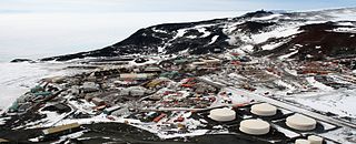
McMurdo Station is an American Antarctic research station on the southern tip of Ross Island, which is in the New Zealand–claimed Ross Dependency on the shore of McMurdo Sound in Antarctica. It is operated by the United States through the United States Antarctic Program (USAP), a branch of the National Science Foundation. The station is the largest community in Antarctica, capable of supporting up to 1,500 residents, and serves as one of three year-round United States Antarctic science facilities. All personnel and cargo going to or coming from Amundsen–Scott South Pole Station first pass through McMurdo. McMurdo Station continues to operate as the hub for American activities on the Antarctic continent. By road, McMurdo is 3 kilometres (1.9 mi) from New Zealand's smaller Scott Base.

<span class="mw-page-title-main">Scott Base</span> New Zealand Antarctic base

Scott Base is a New Zealand Antarctic research station at Pram Point on Ross Island near Mount Erebus in New Zealand's Ross Dependency territorial claim. It was named in honour of Captain Robert Falcon Scott, RN, leader of two British expeditions to the Ross Sea area of Antarctica. The base was set up as support to field research and the centre for research into earth sciences, and now conducts research in many fields, operated by Antarctica New Zealand.

<span class="mw-page-title-main">Vostok Station</span> Russian research station in Antarctica

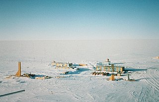
Vostok Station is a Russian research station in inland Princess Elizabeth Land, Antarctica. Founded by the Soviet Union in 1957, the station lies at the southern Pole of Cold, with the lowest reliably measured natural temperature on Earth of −89.2 °C. Research includes ice core drilling and magnetometry. Vostok was named after Vostok, the lead ship of the First Russian Antarctic Expedition captained by Fabian von Bellingshausen. The Bellingshausen Station was named after this captain.

<span class="mw-page-title-main">Showa Station (Antarctica)</span> Antarctic base

Showa Station, sometimes alternately spelled Syowa Station, is a Japanese permanent research station on East Ongul Island in Queen Maud Land, Antarctica. Built in 1957, Showa Station is named for the era in the Japanese calendar during which it was established, the Shōwa period.

<span class="mw-page-title-main">Rothera Research Station</span> Antarctic base in British Antarctic Territory

The Rothera Research Station is a British Antarctic Survey (BAS) base on the Antarctic Peninsula, located at Rothera Point, Adelaide Island. Rothera also serves as the capital of the British Antarctic Territory, a British Overseas Territory.

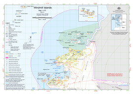
Bousquet Island, 0.6 kilometres (0.3 nmi) long, lies immediately east of Herring Island in the Windmill Islands. It was first mapped from air photos taken by USN Operation Highjump in 1946 and 1947. Named by C. R. Eklund, station scientific leader, for Utilities Man 2nd Class Edward A. Bousquet, USN, a Navy Support force member of the 1957 wintering party at Wilkes Station during the International Geophysical Year (IGY).

<span class="mw-page-title-main">Mirny Station</span> Antarctic station in Australian Antarctic Territory

The Mirny Station is a Russian first Antarctic science station located in Queen Mary Land, Antarctica, on the Antarctic coast of the Davis Sea.

<span class="mw-page-title-main">Law-Racoviță-Negoiță Station</span> Antarctic base

The Law-Racoviță-Negoiță Station, known only as the Law-Racoviță Station until 2011, is the first Romanian station for research and exploration in Antarctica, named after the Romanian explorer Emil Racoviță and inaugurated on January 13, 2006 at the location of a station constructed in 1986 by Australia and donated to Romania. The station may be found in Princess Elizabeth Land, in the Larsemann Hills, 2 kilometres (1.2 mi) away from China's Antarctic Zhongshan Station.

<span class="mw-page-title-main">Zucchelli Station</span> Antarctic base

Zucchelli Station is an Italian seasonal research station in Antarctica, located at Terra Nova Bay on a granitic headland along the coast of the Northern Foothills to the north-east of Gerlache Inlet. It has been named after Mario Zucchelli, director of the activities, which conducted for sixteen years, for the ENEA-Unità Tecnica Antartide as part of the National Antarctic Research Program (PNRA).

<span class="mw-page-title-main">Wilkes Station</span> Antarctic base

Wilkes Station was an Antarctic research station established 29 January 1957 by the United States as one of seven U.S. stations established for the International Geophysical Year (IGY) program in Antarctica. It was taken over by Australia on 7 February 1959.

<span class="mw-page-title-main">Captain Arturo Prat Base</span> Antarctic base

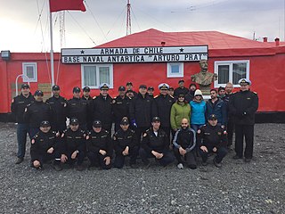
Captain Arturo Prat Base is a Chilean Antarctic research station located at Iquique Cove, Greenwich Island in the South Shetland Islands, Antarctica.

<span class="mw-page-title-main">Macquarie Island Station</span> Subantarctic base in Tasmania

The Macquarie Island Station is a permanent Australian subantarctic research base on Macquarie Island, commonly called Macca, situated in the Southern Ocean and located approximately halfway between mainland Australia and Antarctica, managed by the Australian Antarctic Division (AAD). The station lies at the base of Wireless Hill, between two bays on the isthmus at the northern end of the island.

Wilkins Runway is a single runway aerodrome operated by Australia, located on upper glacier of the ice sheet Preston Heath, Budd Coast, Wilkes Land, on the continent of Antarctica, but 40 km (25 mi) southeast of the actual coast. It is named after Sir Hubert Wilkins, a pioneer of Antarctic aviation and exploration.

<span class="mw-page-title-main">Detaille Island</span> Island off the coast of Antarctica

Detaille Island is a small island off the northern end of the Arrowsmith Peninsula in Graham Land, Antarctica. From 1956 to 1959 it was home to "Base W" of the British Antarctic Survey and closed after the end of the International Geophysical Year (IGY). Detaille was a key monitoring sites during the IGY. It is now often visited by Antarctic cruise ships but is otherwise unoccupied.

Many Antarctic research stations support satellite field camps which are, in general, seasonal camps. The type of field camp can vary – some are permanent structures used during the annual Antarctic summer, whereas others are little more than tents used to support short term activities. Field camps are used for many things, from logistics to dedicated scientific research.

Berkley Island is an island, 1 km long, which marks the north-eastern end of the Swain Islands. It was first mapped from air photos taken by U.S. Navy Operation Highjump, 1946–47, and was included in a survey of the Swain Islands in 1957 by Wilkes Station personnel under Carl R. Eklund. It was named by Eklund for Richard J. Berkley, a geomagnetician with the US-IGY wintering party of 1957 at Wilkes Station.

References

  1. 1 2 Antarctic Station Catalogue (PDF) (catalogue). Council of Managers of National Antarctic Programs. August 2017. p. 29. ISBN   978-0-473-40409-3. Archived (PDF) from the original on 22 October 2022. Retrieved 16 January 2023.
  2. "Living at Casey". Australian Antarctic Division . Department of the Environment, Australian Government. 18 December 2006. Retrieved 11 July 2016.
  3. 1 2 3 4 "Casey station: a brief history". Australian Antarctic Division.
  4. Australian Philatelic Bulletin, Vol. 16, p. 28
  5. 1 2 "Founding Davis and Casey". Australian Antarctic Magazine. Australian Antarctic Division (22). 2012. Archived from the original on 16 November 2012.
  6. 1 2 Rubin, Jeff (2008). Antarctica. Lonely Planet. p. 314. ISBN   9781741045499.{{cite book}}: |work= ignored (help)
  7. "Casey science". Australian Antarctic Division. 17 August 2006. Retrieved 8 July 2016.
  8. Stations, Australian Antarctic Division. Retrieved 28 January 2023.
  9. Phillips, Nicky (1 March 2014). "Life at Antarctica's Casey station". The Sydney Morning Herald . Retrieved 8 July 2016.
  10. Road From the Station to Old Casey (PDF) (Topographical map). Australian Antarctic Data Centre. 1999.
  11. "The annual Casey road building challenge", This week at Casey, Australian Antarctic Division, 21 November 2014
  12. "This week at Casey: 4 March 2016". www.antarctica.gov.au. Bureau of Meteorology. Retrieved 26 April 2017. G'Day from BOM ... This week, BOM staff have been busy finalising the replacement of the weather satellite reception systems.
  13. "About environmental satellites". www.bom.gov.au. Bureau of Meteorology. Retrieved 26 April 2017.
  14. "Australian Antarctic Magazine Issue 10" (PDF). www.antarctica.gov.au. Australian Antarctic Division. 1 March 2006. Archived from the original (PDF) on 10 August 2019. Retrieved 26 April 2017. he first satellite earth-station, which includes a 7.3 m dish antenna, was installed and commissioned at Davis in March 1987. Mawson was commissioned in January 1988, Casey in March 1988, and Macquarie Island in December 1988.
  15. "History-making flight a breeze". Australian Antarctic Division.
  16. Corcoran, Mark (3 March 2009). "What Lies Beneath?" (streaming video and transcript). Foreign Correspondent . Australia: ABC TV.
  17. "Climate Statistics for Casey". Climate statistics for Australian locations. Bureau of Meteorology. Retrieved 23 October 2012.