The International Geophysical Year, also referred to as the third International Polar Year, was an international scientific project that lasted from 1 July 1957 to 31 December 1958. It marked the end of a long period during the Cold War when scientific interchange between East and West had been seriously interrupted. Sixty-seven countries participated in IGY projects, although one notable exception was the mainland People's Republic of China, which was protesting against the participation of the Republic of China (Taiwan). East and West agreed to nominate the Belgian Marcel Nicolet as secretary general of the associated international organization.

Casey Station, commonly called Casey, is one of three permanent stations and research outposts in Antarctica managed by the Australian Antarctic Division (AAD). Casey lies on the northern side of the Bailey Peninsula overlooking Vincennes Bay on the Budd Coast of Wilkes Land in the Australian Antarctic Territory, a territory claimed by Australia. Casey is 3,880 kilometres (2,410 mi) due south of Perth, Western Australia.

Davis Station, commonly called Davis, is one of three permanent bases and research outposts in Antarctica managed by the Australian Antarctic Division (AAD). Davis is situated on the coast of Cooperation Sea in Princess Elizabeth Land, Ingrid Christensen Coast in the Australian Antarctic Territory, a territory claimed by Australia. Davis lies in an Antarctic oasis, a mostly ice-free area known as the Vestfold Hills.

Mawson Station, commonly called Mawson, is one of three permanent bases and research outposts in Antarctica managed by the Australian Antarctic Division (AAD). Mawson lies in Holme Bay in Mac. Robertson Land, East Antarctica in the Australian Antarctic Territory, a territory claimed by Australia. Established in 1954, Mawson is Australia's oldest Antarctic station and the oldest continuously inhabited Antarctic station south of the Antarctic Circle. It houses approximately 20 personnel over winter and up to 53 in summer.
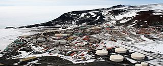
McMurdo Station is an American Antarctic research station on the southern tip of Ross Island, which is in the New Zealand–claimed Ross Dependency on the shore of McMurdo Sound in Antarctica. It is operated by the United States through the United States Antarctic Program (USAP), a branch of the National Science Foundation. The station is the largest community in Antarctica, capable of supporting up to 1,500 residents, and serves as one of three year-round United States Antarctic science facilities. All personnel and cargo going to or coming from Amundsen–Scott South Pole Station first pass through McMurdo. McMurdo Station continues to operate as the hub for American activities on the Antarctic continent. By road, McMurdo is 3 kilometres (1.9 mi) from New Zealand's smaller Scott Base.

Scott Base is a New Zealand Antarctic research station at Pram Point on Ross Island near Mount Erebus in New Zealand's Ross Dependency territorial claim. It was named in honour of Captain Robert Falcon Scott, RN, leader of two British expeditions to the Ross Sea area of Antarctica. The base was set up as support to field research and the centre for research into earth sciences, and now conducts research in many fields, operated by Antarctica New Zealand.

Halley Research Station is a research facility in Antarctica on the Brunt Ice Shelf operated by the British Antarctic Survey (BAS). The base was established in 1956 to study the Earth's atmosphere. Measurements from Halley led to the discovery of the ozone hole in 1985. The current base is the sixth in a line of structures and includes design elements intended to overcome the challenge of building on a floating ice shelf without being buried and crushed by snow. As of 2020, the base has been left unstaffed through winter since 2017, due to concerns over the propagation of an ice crack and how this might cut off the evacuation route in an emergency.

The McMurdo Sound is a sound in Antarctica, known as the southernmost passable body of water in the world, located approximately 1,300 kilometres (810 mi) from the South Pole.
The Commonwealth Trans-Antarctic Expedition (CTAE) of 1955–1958 was a Commonwealth-sponsored expedition that successfully completed the first overland crossing of Antarctica, via the South Pole. It was the first expedition to reach the South Pole overland for 46 years, preceded only by Amundsen's expedition and Scott's expedition in 1911 and 1912.

The United States Antarctic Program is an organization of the United States government which has a presence in the Antarctica continent. Founded in 1959, the USAP manages all U.S. scientific research and related logistics in Antarctica as well as aboard ships in the Southern Ocean.
Operation Deep Freeze is codename for a series of United States missions to Antarctica, beginning with "Operation Deep Freeze I" in 1955–56, followed by "Operation Deep Freeze II", "Operation Deep Freeze III", and so on.. Given the continuing and constant US presence in Antarctica since that date, "Operation Deep Freeze" has come to be used as a general term for US operations in that continent, and in particular for the regular missions to resupply US Antarctic bases, coordinated by the United States military. Task Force 199 was involved.

Scott's Hut is a building located on the north shore of Cape Evans on Ross Island in Antarctica. It was erected in 1911 by the British Antarctic Expedition of 1910–1913 led by Robert Falcon Scott.

Multiple governments have set up permanent research stations in Antarctica and these bases are widely distributed. Unlike the drifting ice stations set up in the Arctic, the current research stations of the Antarctic are constructed either on rocks or on ice that are fixed in place.

Fossil Bluff is a seasonal British aircraft refuelling station located on the east coast of Alexander Island in Antarctica. In operation since 1961, its facilities provide fuel, storage, and ancillary support for British exploration and operations during the summer season, October through March. The site is adjacent to a natural, north–south travelling route along the George VI Ice Shelf.

Marble Point is a rocky promontory on the coast of Victoria Land, Antarctica. The United States operates a station at the point. The outpost is used as a helicopter refueling station supporting scientific research in the nearby continental interior, such as the McMurdo Dry Valleys. Dependent upon the weather conditions at the time, helicopters are able to fly in and out of the station 24 hours a day during the summer research season.

Cape Adare is a prominent cape of black basalt forming the northern tip of the Adare Peninsula and the north-easternmost extremity of Victoria Land, East Antarctica.

Winter Quarters Bay is a small cove of McMurdo Sound, Antarctica, located 2,200 miles (3,500 km) due south of New Zealand at 77°50'S. The harbor is the southernmost port in the Southern Ocean and features a floating ice pier for summer cargo operations. The bay is approximately 250m wide and long, with a maximum depth of 33m. The name Winter Quarters Bay refers to Robert Falcon Scott's National Antarctic Discovery Expedition (1901–04) which wintered at the site for two seasons.

The Vernadsky Research Base is a Ukrainian Antarctic research station at Marina Point on Galindez Island in the Argentine Islands, not far from Kyiv Peninsula. The region is under territorial claims between three countries. The single Ukrainian Antarctic station is named after the mineralogist Volodymyr Vernadsky (1863–1945) who was the first president of the National Academy of Sciences of Ukraine.

MV Nella Dan was one of the famous 'Dan' ships of the Danish J. Lauritzen A/S Lines that were almost synonymous with ANARE shipping through the early years of Australia's official Antarctic program. Others in the fleet included Kista Dan, Magga Dan and Thala Dan.
Cameron Island is a small island just north of Hailstorm Island, in the Swain Islands, Antarctica. This region was photographed from the air by U.S. Navy Operation Highjump (1946–47), ANARE (1956), and the Soviet expedition (1956). The island was included in a 1957 ground survey by C.R. Eklund, who named it for Richard L. Cameron, chief glaciologist at Wilkes Station, 1957.


