Greenwich Island is an island 24 km (15 mi) long and from 0.80 to 9.66 km wide, lying between Robert Island and Livingston Island in the South Shetland Islands. Surface area 142.7 square kilometres (55.1 sq mi). The name Greenwich Island dates back to at least 1821 and is now established in international usage.
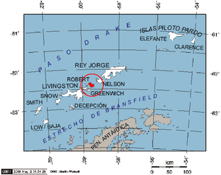
Robert Island or Mitchells Island or Polotsk Island or Roberts Island is an island 11 miles (18 km) long and 8 miles (13 km) wide, situated between Nelson Island and Greenwich Island in the South Shetland Islands, Antarctica. Robert Island is located at 62°24′S59°30′W. Surface area 132 km2 (51 sq mi). The name "Robert Island" dates back to around 1821 and is now established in international usage.

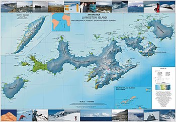
Boyana Glacier in Levski Ridge, Tangra Mountains on Livingston Island, South Shetland Islands in Antarctica is situated southeast of Macy Glacier and west-southwest of Srebarna Glacier. It is bounded by Vazov Rock on the west, St. Naum Peak, Starosel Gate, Silistra Knoll and Kotel Gap on the north, and Christoff Cliff on the east. The glacier extends 3 km in east-west direction and 1.6 km in north-south direction, and flows southeastward into the Bransfield Strait between Vazov Point and Aytos Point.

Burgas Peninsula is a predominantly ice-covered peninsula forming the east extremity of Livingston Island in the South Shetland Islands, Antarctica extending 10 km in the east-northeast direction towards Renier Point and 4.7 km wide. It is bounded by Bruix Cove, Moon Bay and Mugla Passage to the north, and Bransfield Strait to the south-southeast. The peninsula's interior is occupied by the Delchev Ridge of Tangra Mountains.

Kabile Island is an Antarctic island extending 700 m (770 yd) in south–north direction and 450 m (490 yd) wide, situated off the north coast of Greenwich Island in the South Shetland Islands, Antarctica. It has a surface area of 19 hectares.

Murgash Glacier is the 3.4 km long and 3.2 km wide glacier on Greenwich Island in the South Shetland Islands, Antarctica situated southeast of Yakoruda Glacier, south of Teteven Glacier, southwest of Traub Glacier and west-northwest of Bravo Glacier. It is bounded by Lloyd Hill on the northwest, Tile Ridge on the east and Hebrizelm Hill on the southeast, and drains southwards into Kramolin Cove in McFarlane Strait between Yovkov Point and Kaspichan Point.
Musala Glacier on Greenwich Island in the South Shetland Islands, Antarctica is situated northeast of Targovishte Glacier, east-northeast of Zheravna Glacier and southeast of Fuerza Aérea Glacier. It is bounded by St. Kiprian Peak to the south, Vratsa Peak to the southwest, central Breznik Heights to the west, and Ilarion Ridge bordering Hardy Cove to the northeast, extends 2 nautical miles in east-west direction and 1.2 nautical miles in north-south direction, and drains eastwards into Bransfield Strait north of Fort Point.
Teteven Glacier is a glacier on Greenwich Island in the South Shetland Islands, Antarctica situated east of Yakoruda Glacier, west of Quito Glacier, northwest of Traub Glacier and north of Murgash Glacier. It extends 6.5 km in east-west direction and 3.8 km in north-south direction, and drains the north slopes of Dryanovo Heights into the Drake Passage in Haskovo Cove and Skaptopara Cove between Miletich Point and the ice-free area at Agüedo Point.

Vergilov Rocks are a group of rocks off Bulgarian Beach on Hurd Peninsula in eastern Livingston Island in the South Shetland Islands, Antarctica, consisting of one main rock and two adjacent smaller ones submerging at high water.
Quito Glacier is a glacier draining the northeast slopes of Mount Plymouth and flowing northeastwards into the sea west of Canto Point in north Greenwich Island, South Shetland Islands. It was named after the capital of Ecuador, c. 1990, by the Ecuadorian Antarctic Expedition.

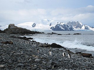
Desolation Island is one of the minor islands in the South Shetlands archipelago, Antarctica situated at the entrance to Hero Bay, Livingston Island. The island is V-shaped with its northern coast indented by Kozma Cove. Surface area 3.12 square kilometres (1.20 sq mi).

McFarlane Strait is a strait lying between Greenwich Island and Livingston Island, in the South Shetland Islands off Antarctica. It is 24 kilometres (13 nmi) long and 3 kilometres (1.6 nmi) wide. The name appears on an 1822 chart by Captain George Powell, a British sealer, and is now well established in international usage.

Hespérides Point is a rocky point of land projecting into South Bay north-northwest of Johnsons Dock, Livingston Island in the South Shetland Islands, Antarctica and forming the southwest side of the entrance to Emona Anchorage. Surmounted by Hesperides Hill. The area was visited by 19th century sealers operating from nearby Johnsons Dock.
Dee Island is the ice-free island lying between Greenwich Island and Aitcho Islands in the South Shetland Islands, Antarctica and is separated from Greenwich Island to the south by the 850 m (930 yd) wide Orión Passage and from Aitcho Islands to the northeast by the 1.1 km (0.68 mi) wide Villalón Passage. Extending 1.9 by 1.37 km, with the conspicuous Burro Peaks in the southeast rising to 190 m (620 ft), and surface area 197 hectares. The small Montufar Island and Araguez Island are lying 650 m (710 yd) east of Dee Island and 200 m (220 yd) east of its southern tip Dragash Point respectively. The area was visited by 19th century sealers.

Raquelia Rocks is a group of three adjacent rocks in eastern South Bay, Livingston Island in the South Shetland Islands, Antarctica formed by an offshoot of Atlantic Club Ridge halfway along the Zodiac boat route linking the Spanish Antarctic Base and the Bulgarian Antarctic Base on the island. The area was visited by early 19th century sealers operating from nearby Johnsons Dock.
Orión Point is an ice-free point on the north coast of Greenwich Island in the South Shetland Islands, Antarctica forming the east side of the entrance to Guayaquil Bay. The feature is named after the Ecuadorian Antarctic Expedition's ship Orión.
Guayaquil Bay is the 2.59 km wide bay indenting for 1.25 km the north coast of Greenwich Island in the South Shetland Islands, Antarctica and entered between Agüedo Point and Orión Point. The bay is used by ships servicing the Ecuadorian Antarctic base Pedro Vicente Maldonado situated 560 m south-southwest of Orión Point. The area was visited by 19th century sealers operating from nearby Clothier Harbour.
Galápagos Cove is the small, 210 m wide cove indenting for 70 m the northeast coast of Greenwich Island in the South Shetland Islands, Antarctica and entered between Spark Point and Figueroa Point.
Jambelí Cove is the 620 m wide cove indenting for 140 m the north coast of Greenwich Island in the South Shetland Islands, Antarctica and entered between Spark Point and Orión Point. The area was visited by 19th century sealers operating from nearby Clothier Harbour.

Risopatrón Base, also Luis Risopatrón Base, is a small Chilean Antarctic research base in the northwest of Robert Island in the South Shetland Islands, Antarctica situated on the isthmus linking Coppermine Peninsula to Alfatar Peninsula and bounded by Carlota Cove to the north and Coppermine Cove to the south. Established as a refuge in 1949 and opened as a base in 1954, the facility supports summer research in geology, geophysics and terrestrial biology.


