A. B. Dobrowolski Polar Station

Last updated
Dobrowolski Station
A. B. Dobrowolski
Dobrowolski1979.jpg
Buildings of the Dobrowolski Station (Bunger Hills, Antarctica) in 1979 (Photo: Zbigniew Battke).
Antarctica relief location map.jpg
Red pog.svg
Dobrowolski Station
Location of Dobrowolski Station in Antarctica
Coordinates: 66°16′28″S100°45′00″E / 66.274514°S 100.749889°E / -66.274514; 100.749889
CountryFlag of Poland.svg  Poland
Location in Antarctica Algae Lake
Bunger Hills
Wilkes Land
Administered byInstitute of Geophysics, Polish Academy of Sciences
Established1959 (1959)
ActiveYes
Named for Antoni Bolesław Dobrowolski
Elevation
[1]
29 m (95 ft)
Population
 (2017) [1]
  Summer
10
  Winter
0
Station location on a map Stacja Dobrowolskiego.png
Station location on a map

A.B. Dobrowolski Polar Station (Polish : Stacja im. A.B. Dobrowolskiego) is an occasionally active Polish polar research station in Antarctica. It is located at the edge of the Algae Lake, Bunger Hills region in the Wilkes Land and was originally constructed by the Soviet Union. It is one of the two Polish stations in Antarctica, the other being the Henryk Arctowski Polish Antarctic Station.

Contents

The station is named after Polish geophysicist, meteorologist and explorer Antoni Bolesław Dobrowolski. [2]

In January 2022, it was reported that Polish scientists have arrived to staff the station for the first time since 43 years. [3]

Oasis Station

The research station was built by the Soviet Antarctic Expedition in 1956 and named Oazis (Оазис, English: Oasis). The station was handed over by the Soviet Academy of Sciences to the Polish Academy of Sciences in January 1959 [2] and given its current name. It was manned briefly by the Polish expedition, which carried out a number of studies, primarily in the fields of gravimetry and geomorphology. [4] The station has not been used regularly since, due to the lack of funds and the high costs of air transport, [4] and there are no plans to reopen the station as a permanent institution. [5] The station has been visited periodically by Polish and other research teams. [6] [7] The last regular Polish team was reported to have visited the station in 1979. [8] [9] [10] A 1998 Polish statistical yearbook described the base as "periodically active". [11] Thereafter, the station was officially described as "inactive and conserved, but not abandoned", and was only occasionally visited by tourists, such as those who documented their visit in 2010, until its official reactivation in 2022. [7] The 2022 expedition is tasked with preparing a detailed inventory of the station and installing some new research equipment, both necessary in order to return the station to regular seasonal activity.

Historic monuments

The magnetic observatory building, along with a plaque commemorating the establishment of Oasis Station in 1956, has been designated a Historic Site or Monument (HSM 10) following a proposal by Russia to the Antarctic Treaty Consultative Meeting (ATCM). The concrete pillar erected by the Polish expedition to measure acceleration due to gravity has similarly been designated a Historic Site or Monument (HSM 49) following a proposal by Poland to the ATCM. [12]

See also

Related Research Articles

<span class="mw-page-title-main">Vostok Station</span> Russian research station in Antarctica

Vostok Station is a Russian research station in inland Princess Elizabeth Land, Antarctica. Founded by the Soviet Union in 1957, the station lies at the southern Pole of Cold, with the lowest reliably measured natural temperature on Earth of −89.2 °C. Research includes ice core drilling and magnetometry. Vostok was named after Vostok, the lead ship of the First Russian Antarctic Expedition captained by Fabian von Bellingshausen. The Bellingshausen Station was named after this captain.

Włodzimierz Puchalski was a Polish photographer and film director. He was a pioneer of wildlife film-making in Poland and became famous for publishing his album "Bezkrwawe łowy" in 1954.

<span class="mw-page-title-main">Showa Station (Antarctica)</span> Antarctic base

Showa Station, sometimes alternately spelled Syowa Station, is a Japanese permanent research station on East Ongul Island in Queen Maud Land, Antarctica. Built in 1957, Showa Station is named for the era in the Japanese calendar during which it was established, the Shōwa period.

<span class="mw-page-title-main">Base General Bernardo O'Higgins Riquelme</span> Antarctic base

Base General Bernardo O'Higgins Riquelme, also Base Libertador General Bernardo O'Higgins Riquelme, or shortly Bernardo O'Higgins, named after Bernardo O'Higgins, is a permanently staffed Chilean research station in Antarctica and the capital of Antártica Commune. It lies at an elevation of 13 m, about 30 km south-west of Prime Head, the northernmost point of the Antarctic Peninsula, at Cape Legoupil.

<span class="mw-page-title-main">Stonington Island</span> Island in Antarctica

Stonington Island is a rocky island lying 1.8 km (1.1 mi) northeast of Neny Island in the eastern part of Marguerite Bay off the west coast of Graham Land, Antarctica. It is 0.75 km (0.47 mi) long from north-west to south-east and 0.37 km (0.23 mi) wide, yielding an area of 20 ha. It was formerly connected by a drifted snow slope to Northeast Glacier on the mainland. Highest elevation is Anemometer Hill which rises to 25 m (82 ft).

<span class="mw-page-title-main">Henryk Arctowski Polish Antarctic Station</span> Antarctic base in King George Island

Henryk Arctowski Polish Antarctic Station is a Polish research station on King George Island, off the coast of Antarctica.

<span class="mw-page-title-main">Mirny Station</span> Antarctic station in Australian Antarctic Territory

The Mirny Station is a Russian first Antarctic science station located in Queen Mary Land, Antarctica, on the Antarctic coast of the Davis Sea.

<span class="mw-page-title-main">Pole of Inaccessibility research station</span> Former Antarctic base in Kemp Land

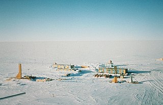
The Pole of Inaccessibility research station is a defunct Soviet research station in Kemp Land, Antarctica, at the southern pole of inaccessibility as defined in 1958 when the station was established. Later definitions give other locations, all relatively near this point. It performed meteorological observations from 14 to 26 December 1958. The Pole of Inaccessibility has the world's coldest year-round average temperature of −58.2 °C (−72.8 °F).

<span class="mw-page-title-main">Henryk Arctowski</span> Polish scientist and explorer

Henryk Arctowski, born Henryk Artzt, was a Polish scientist and explorer.

<span class="mw-page-title-main">Cape Evans</span> Headland in Antarctica

Cape Evans is a rocky cape on the west side of Ross Island, Antarctica, forming the north side of the entrance to Erebus Bay.

<span class="mw-page-title-main">Great Wall Station (Antarctica)</span> Antarctic base

The Great Wall Station is the first Chinese research station in Antarctica and opened on 20 February 1985. It lies on the Fildes Peninsula on King George Island, and is about 2.5 kilometres (1.6 mi) from the Chilean Frei Montalva Station, and 960 kilometres (600 mi) from Cape Horn. The station is sited on ice-free rock, about 10 metres (33 ft) above sea level.

<span class="mw-page-title-main">Antoni Bolesław Dobrowolski</span>

Antoni Bolesław Dobrowolski was a Polish geophysicist, meteorologist and explorer.

<span class="mw-page-title-main">Captain Arturo Prat Base</span> Antarctic base

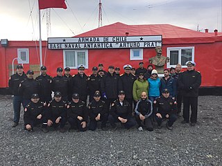
Captain Arturo Prat Base is a Chilean Antarctic research station located at Iquique Cove, Greenwich Island in the South Shetland Islands, Antarctica.

<span class="mw-page-title-main">Religion in Antarctica</span> Religion in Antarctica

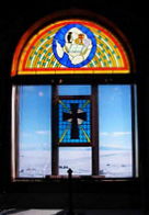
Religion in Antarctica is largely dominated by Christianity, with churches being the only religious buildings on the continent. Although used regularly for Christian worship, the Chapel of the Snows has also been used for Buddhist and Baháʼí Faith ceremonies. Some of the early religious buildings are now protected as important historical monuments.

<span class="mw-page-title-main">Schirmacher Oasis</span>

The Schirmacher Oasis is a 25 km (16 mi) long and up to 3 km (1.9 mi) wide ice-free plateau with more than 100 freshwater lakes. It is situated in the Schirmacher Hills on the Princess Astrid Coast in Queen Maud Land in East Antarctica and is, on average, 100 m (330 ft) above sea level. With an area of 34 km2 (13 sq mi), the Schirmacher Oasis ranks among the smallest Antarctic oases and is a typical polar desert.

Walkabout Rocks is a prominent rock exposure along the coast at the north-eastern extremity of the Vestfold Hills, about 0.5 nautical miles south of the Wyatt Earp Islands of Princess Elizabeth Land, Antarctica. It was mapped from aerial photographs taken by the Lars Christensen Expedition, 1936–37.

<span class="mw-page-title-main">Buromskiy Island</span> Island in Queen Mary Land, Antarctica

Buromskiy Island is a small island lying 0.6 km (0.37 mi) south of Haswell Island in the Haswell Islands of Antarctica. About 200 m long and 100 m wide, it was discovered and mapped by the Australasian Antarctic Expedition under Douglas Mawson, 1911–14. It was photographed by the Soviet expedition of 1958 and named for N.I. Buromskiy, expedition hydrographer who lost his life in the Antarctic in 1957. It lies 2.7 km north of Mabus Point, the site of Russia's Mirny Station.

Metchnikoff Point is a point forming the western extremity of Pasteur Peninsula in northern Brabant Island, in the Palmer Archipelago, Antarctica. It was first charted by the Third French Antarctic Expedition, 1903–05, and named by Jean-Baptiste Charcot for Russian-born zoologist and bacteriologist Élie Metchnikoff, who succeeded Louis Pasteur as the director of the Pasteur Institute in Paris.

Stanisław Baranowski was a Polish glaciologist and leader or member of a number of scientific expeditions to Spitsbergen and Antarctica. He died as a result of an accident near the Henryk Arctowski Polish Antarctic Station while on expedition. At the time of his death, he was head of the Department of Metereology and Climatology at the University of Wrocław.

<span class="mw-page-title-main">East Base</span> Antarctic base

East Base on Stonington Island is the oldest American research station in Antarctica, having been commissioned by Franklin D. Roosevelt in 1939. The station was built as part of two US wintering expeditions – United States Antarctic Service Expedition (1939–1941) and Ronne Antarctic Research Expedition (1947–1948). The base covers 1,000 metres (3,300 ft) from north to south and 500 metres (1,600 ft) from east to west. The base was accorded the status of one of the Historic Sites and Monuments in Antarctica on 7 May 2004.

References

  1. 1 2 Antarctic Station Catalogue (PDF) (catalogue). Council of Managers of National Antarctic Programs. August 2017. p. 119. ISBN   978-0-473-40409-3. Archived (PDF) from the original on 22 October 2022. Retrieved 16 January 2023.
  2. 1 2 "Dobrowolski Station (A.B.)". Scientific Committee on Antarctic Research. SCAR Gazetteer Ref. No 3714. Archived from the original on 2014-04-07 via the Composite Gazetteer of Antarctica.
  3. "Polish Antarctic station comes out of hibernation after 43 years". January 8, 2022. Archived from the original on 2022-01-08.
  4. 1 2 Geographical journal. 1973. p. 204. Retrieved 3 September 2013.
  5. Geographical journal. 1973. p. 206. Retrieved 3 September 2013.
  6. "Waly lodowo-morenowe Antarktydy". Polish Geographical Review. Institute of Geography and Spatial Organization PAS. 56: 101. 1984. ISSN   0033-2143.
  7. 1 2 Chandler, Jo (2010-01-06). "Cold War relics frozen in Antarctic". The Age . Archived from the original on 2018-03-08. Retrieved 2013-09-03.
  8. "Archived copy". Archived from the original on 2013-10-29. Retrieved 2013-09-03.{{cite web}}: CS1 maint: archived copy as title (link)
  9. "Polacy w Antarktyce « Młody Technik". Mt.com.pl. 2013-01-24. Archived from the original on 2013-10-29. Retrieved 2013-09-03.
  10. "Z wyprawami radzieckimi". Arctowski.pl. Retrieved 2013-09-03.
  11. Mały rocznik Statystyczny. Nakładem Głównego Urzędu Statystycznego. 1998. p. 28. Retrieved 3 September 2013.
  12. "List of Historic Sites and Monuments approved by the ATCM (2012)" (PDF). Antarctic Treaty Secretariat. 2012. Retrieved 2013-10-26.