South Georgia and the South Sandwich Islands (SGSSI) is a British Overseas Territory in the southern Atlantic Ocean. It is a remote and inhospitable collection of islands, consisting of South Georgia and a chain of smaller islands known as the South Sandwich Islands. South Georgia is 165 kilometres (103 mi) long and 35 kilometres (22 mi) wide and is by far the largest island in the territory. The South Sandwich Islands lie about 700 kilometres (430 mi) southeast of South Georgia. The territory's total land area is 3,903 km2 (1,507 sq mi). The Falkland Islands are about 1,300 kilometres (810 mi) west from its nearest point.

The climate of Antarctica is the coldest on Earth. The continent is also extremely dry, averaging 166 mm (6.5 in) of precipitation per year. Snow rarely melts on most parts of the continent, and, after being compressed, becomes the glacier ice that makes up the ice sheet. Weather fronts rarely penetrate far into the continent, because of the katabatic winds. Most of Antarctica has an ice-cap climate with extremely cold and dry weather.

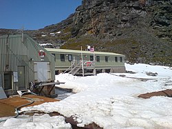
Signy Island is a small subantarctic island in the South Orkney Islands of Antarctica. It was named by the Norwegian whaler Petter Sørlle (1884–1933) after his wife, Signy Therese.

Mawson Station, commonly called Mawson, is one of three permanent bases and research outposts in Antarctica managed by the Australian Antarctic Division (AAD). Mawson lies in Holme Bay in Mac. Robertson Land, East Antarctica in the Australian Antarctic Territory, a territory claimed by Australia. Established in 1954, Mawson is Australia's oldest Antarctic station and the oldest continuously inhabited Antarctic station south of the Antarctic Circle. It houses approximately 20 personnel over winter and up to 53 in summer.

Scott Base is a New Zealand Antarctic research station at Pram Point on Ross Island near Mount Erebus in New Zealand's Ross Dependency territorial claim. It was named in honour of Captain Robert Falcon Scott, RN, leader of two British expeditions to the Ross Sea area of Antarctica. The base was set up as support to field research and the centre for research into earth sciences, and now conducts research in many fields, operated by Antarctica New Zealand.

Halley Research Station is a research facility in Antarctica on the Brunt Ice Shelf operated by the British Antarctic Survey (BAS). The base was established in 1956 to study the Earth's atmosphere. Measurements from Halley led to the discovery of the ozone hole in 1985. The current base is the sixth in a line of structures and includes design elements intended to overcome the challenge of building on a floating ice shelf without being buried and crushed by snow. As of 2020, the base has been left unstaffed through winter since 2017, due to concerns over the propagation of an ice crack and how this might cut off the evacuation route in an emergency.
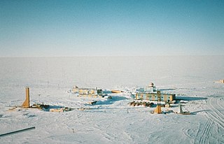
Vostok Station is a Russian research station in inland Princess Elizabeth Land, Antarctica. Founded by the Soviet Union in 1957, the station lies at the southern Pole of Cold, with the lowest reliably measured natural temperature on Earth of −89.2 °C. Research includes ice core drilling and magnetometry. Vostok was named after Vostok, the lead ship of the First Russian Antarctic Expedition captained by Fabian von Bellingshausen. The Bellingshausen Station was named after this captain.
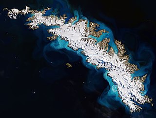
South Georgia is an island in the South Atlantic Ocean that is part of the British Overseas Territory of South Georgia and the South Sandwich Islands. It lies around 1,400 kilometres (870 mi) east of the Falkland Islands. Stretching in the east–west direction, South Georgia is around 170 kilometres (106 mi) long and has a maximum width of 35 kilometres (22 mi). The terrain is mountainous, with the central ridge rising to 2,935 metres (9,629 ft) at Mount Paget. The northern coast is indented with numerous bays and fjords, serving as good harbours.

The Dumont d'Urville Station is a French scientific station in Antarctica on Île des Pétrels, archipelago of Pointe-Géologie in Adélie Land. It is named after explorer Jules Dumont d'Urville, whose expedition landed on Débarquement Rock in the Dumoulin Islands at the northeast end of the archipelago on January 21, 1840. It is operated by the "French Polar Institute Paul-Émile Victor", a joint operation of French public and para-public agencies. It is the administrative centre of Adélie Land.

The South Orkney Islands are a group of islands in the Southern Ocean, about 604 km (375 mi) north-east of the tip of the Antarctic Peninsula and 844 km (524 mi) south-west of South Georgia Island. They have a total area of about 620 km2 (240 sq mi). The islands are claimed both by Britain, and by Argentina as part of Argentine Antarctica. Under the 1959 Antarctic Treaty, sovereignty claims are held in abeyance.

Operation Tabarin was the code name for a secret British expedition to the Antarctic during World War Two, operational 1943–46. Conducted by the Admiralty on behalf of the Colonial Office, its primary objective was to strengthen British claims to sovereignty of the British territory of the Falkland Islands Dependencies (FID), to which Argentina and Chile had made counter claims since the outbreak of war. This was done by establishing permanently occupied bases, carrying out administrative activities such as postal services and undertaking scientific research. The meteorological observations made aided Allied shipping in the South Atlantic Ocean.

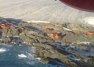
Esperanza Base is a permanent, all-year-round Argentine research station in Hope Bay, Trinity Peninsula. It is one of only two civilian settlements in Antarctica. The base's motto is Permanencia, un acto de sacrificio.

The Rothera Research Station is a British Antarctic Survey (BAS) base on the Antarctic Peninsula, located at Rothera Point, Adelaide Island. Rothera also serves as the capital of the British Antarctic Territory, a British Overseas Territory.

Base Orcadas is an Argentine scientific station in Antarctica, and the oldest of the stations in Antarctica still in operation. It is located on Laurie Island, one of the South Orkney Islands, at 4 meters (13 ft) above sea level and 170 meters (558 ft) from the coastline. Established by the Scottish National Antarctic Expedition in 1903 and transferred to the Argentine government in 1904, the base has been permanently populated since, being one of six Argentine permanent bases in Argentina's claim to Antarctica, and the first permanently inhabited base in Antarctica.

Marambio Station is a permanent, all year-round Argentine Antarctica station named after Vice-Commodore Gustavo Argentino Marambio, an Antarctic aviation pioneer. It is located in Marambio Island, Graham Land, Antarctic Peninsula, some 100 km (60 mi) from the coastal civilian village of Esperanza.

Multiple governments have set up permanent research stations in Antarctica and these bases are widely distributed. Unlike the drifting ice stations set up in the Arctic, the current research stations of the Antarctic are constructed either on rocks or on ice that are fixed in place.

The Mirny Station is a Russian first Antarctic science station located in Queen Mary Land, Antarctica, on the Antarctic coast of the Davis Sea.
The Teniente Luis Carvajal Villaroel Antarctic Base is a seasonal Chilean Antarctic base on the south-west tip of Adelaide Island, in Graham Land off the west coast of the Antarctic Peninsula. The nearest land is the Magallanes – the station is in the Antarctic territory claimed by Chile.

The Vernadsky Research Base is a Ukrainian Antarctic research station at Marina Point on Galindez Island in the Argentine Islands, not far from Kyiv Peninsula. The region is under territorial claims between three countries. The single Ukrainian Antarctic station is named after the mineralogist Vladimir Vernadsky (1863–1945) who was the first president of the National Academy of Sciences of Ukraine.
Many research stations in Antarctica support satellite field camps which are, in general, seasonal camps. The type of field camp can vary – some are permanent structures used during the annual Antarctic summer, whereas others are little more than tents used to support short term activities. Field camps are used for many things, from logistics to dedicated scientific research.