
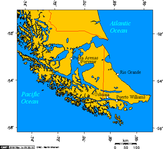
Tierra del Fuego is an archipelago off the southernmost tip of the South American mainland, across the Strait of Magellan.
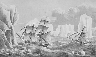
The history of Antarctica emerges from early Western theories of a vast continent, known as Terra Australis, believed to exist in the far south of the globe. The term Antarctic, referring to the opposite of the Arctic Circle, was coined by Marinus of Tyre in the 2nd century AD.

The Magallanes Region, officially the Magallanes y la Antártica Chilena Region, is one of Chile's 16 first order administrative divisions. It is the southernmost, largest, and second least populated region of Chile. It comprises four provinces: Última Esperanza, Magallanes, Tierra del Fuego, and Antártica Chilena.

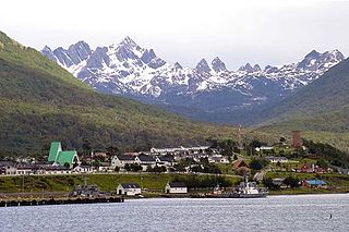
Ushuaia is the capital of Tierra del Fuego, Antártida e Islas del Atlántico Sur Province, Argentina. With a population of 82,615 and a location below the 54th parallel south latitude, Ushuaia claims the title of world's southernmost city.

Tierra del Fuego, officially the Province of Tierra del Fuego, Antarctica and South Atlantic Islands, is the southernmost, smallest, and least populous Argentine province. The provincial capital city is Ushuaia, from a native word meaning "bay towards the end".

The Magellanic subpolar forests are a terrestrial ecoregion of southernmost South America, covering parts of southern Chile and Argentina, and are part of the Neotropical realm. It is a temperate broadleaf and mixed forests ecoregion, and contains the world's southernmost forests.

Isla Grande de Tierra del Fuego also formerly Isla de Xátiva is an island near the southern tip of South America from which it is separated by the Strait of Magellan. The western portion (61.4%) of the island is in Chile, while the eastern portion is in Argentina. It forms the major landmass in an extended group of islands or archipelago also known as Tierra del Fuego.
Southernmost settlements are cities, towns, weather stations or permanent military bases which are farther south than latitude 45°S. They are closely related to the Southern Ocean or either the Roaring Forties or Furious Fifties. Antarctic bases are excluded due to not having a permanent population.
Puerto Williams is a city, port and naval base on Navarino Island in Chile, and is also the southernmost populated settlement in the world. It faces the Beagle Channel. It is the capital of the Chilean Antarctic Province, one of four provinces in the Magellan and Chilean Antarctica Region, and administers the communes of Chilean Antarctic Territory and Cabo de Hornos. It has a population of 2,874, including both naval personnel and civilians. Puerto Williams claims the title of world's southernmost city. The settlement was founded in 1953, and was first named Puerto Luisa. The town was later named after John Williams Wilson, a British man who founded Fuerte Bulnes, the first settlement in the Strait of Magellan. It has served primarily as a naval base for Chile. The Chilean Navy runs the Guardiamarina Zañartu Airport and hospital, as well as nearby meteorological stations. Since the late 20th century, the number of navy personnel has decreased in Puerto Williams and the civilian population has increased. In that period, tourism and support of scientific research have contributed to an increase in economic activity.

Nothofagus antarctica is a deciduous tree or shrub native to southern Chile and Argentina from about 36°S to Tierra del Fuego, where it grows mainly in the diminishing temperate rainforest.

Antártica Chilena Province is the southernmost of the four provinces in Chile's southernmost region, Magallanes and Antártica Chilena Region (XII). The capital is Puerto Williams. The province comprises the extreme southern part of Isla Grande de Tierra del Fuego, the islands south and west of Isla Grande, and Chile's claims in Antarctica. The province is administratively divided into two communes (comunas): Cabo de Hornos, located at the southern tip of South America, and Antártica, a wedge-shaped claim of Antarctica, which is not internationally recognized. Its total area of 1,265,853.7 km2 (488,749 sq mi) makes it almost twice as large as all other provinces of Chile combined.

Argentine Antarctica is an area on Antarctica claimed by Argentina as part of its national territory. It consists of the Antarctic Peninsula and a triangular section extending to the South Pole, delimited by the 25° West and 74° West meridians and the 60° South parallel. This region overlaps with British and Chilean claims in Antarctica. None of these claims have widespread international recognition.

Puerto Toro is a hamlet on the eastern coast of Navarino Island, Chile. Puerto Toro was founded in 1892 during the Tierra del Fuego Gold Rush by Governor of Punta Arenas Señoret.

Navarino Island is a Chilean island located between Isla Grande de Tierra del Fuego, to the north, and Cape Horn, to the south. The island forms part of the Commune of Cabo de Hornos, the southernmost commune in Chile and in the world, belonging to Antártica Chilena Province in the XII Region of Magallanes and Chilean Antarctica. Its population is concentrated primarily in the communal capital, Puerto Williams, and in small settlements like Puerto Navarino, Río Guanaco and Puerto Toro. The highest point of the island is Pico Navarino at 1,195 m (3,921 ft). The island is a popular destination for fly-fishers.
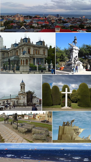
Punta Arenas is the capital city of Chile's southernmost region, Magallanes and Antarctica Chilena. Although officially renamed as Magallanes in 1927, the name was changed back to Punta Arenas in 1938. The city is the largest south of the 46th parallel south and the most populous southernmost city in Chile and the Americas. Due to its location, it is also the coldest coastal city with more than 100,000 inhabitants in Latin America. Punta Arenas is one of the world's most southerly ports and serves as an Antarctic gateway city.

Nothofagus betuloides, Magellan's beech or guindo, is a tree native to southern Patagonia.

Reclus, also written as Reclús, is a volcano located in the Southern Patagonian Ice Field, Chile. Part of the Austral Volcanic Zone of the Andes, its summit rises 1,000 metres (3,300 ft) above sea level and is capped by a crater about 1 kilometre (0.62 mi) wide. Close to the volcano lies the Amalia Glacier, which is actively eroding Reclus.

Tierra del Fuego National Park is a national park on the Argentine part of the island of Tierra del Fuego, within Tierra del Fuego Province in the ecoregion of Patagonic Forest and Altos Andes, a part of the subantarctic forest. Established on 15 October 1960 under the Law 15.554 and expanded in 1966, it was the first shoreline national park to be established in Argentina.

The Antarctandes, also known as the Antarctic Peninsula cordillera, is the mountain range that is located on the northern Antarctic Peninsula, in the Graham Land and Palmer Land regions of Antarctica and may also be considered to extend across the continent.
Fueguino is a volcanic field in Chile. The southernmost volcano in the Andes, it lies on Tierra del Fuego's Cook Island and also extends over nearby Londonderry Island. The field is formed by lava domes, pyroclastic cones, and a crater lake.