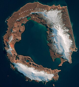
Deception Island is in the South Shetland Islands close to the Antarctic Peninsula with a large and usually "safe" natural harbor, which is occasionally affected by the underlying active volcano. This island is the caldera of an active volcano, which seriously damaged local scientific stations in 1967 and 1969. The island previously held a whaling station. It is now a tourist destination with over 15,000 visitors per year. Two research stations are operated by Argentina and Spain during the summer season. While various countries have asserted sovereignty, it is still administered under the Antarctic Treaty System.

The British Antarctic Territory (BAT) is a sector of Antarctica claimed by the United Kingdom as one of its 14 British Overseas Territories, of which it is by far the largest by area. It comprises the region south of 60°S latitude and between longitudes 20°W and 80°W, forming a wedge shape that extends to the South Pole, overlapped by the Antarctic claims of Argentina and Chile. The claim to the region has been suspended since the Antarctic Treaty came into force in 1961.

Operation Tabarin was the code name for a secret British expedition to the Antarctic during World War Two, operational 1943–46. Conducted by the Admiralty on behalf of the Colonial Office, its primary objective was to strengthen British claims to sovereignty of the British territory of the Falkland Islands Dependencies (FID), to which Argentina and Chile had made counter claims since the outbreak of war. This was done by establishing permanently occupied bases, carrying out administrative activities such as postal services and undertaking scientific research. The meteorological observations made aided Allied shipping in the South Atlantic Ocean.

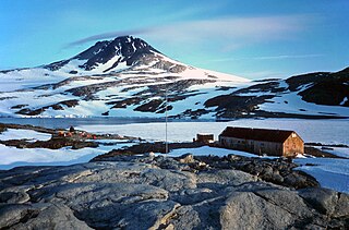
Hope Bay on Trinity Peninsula, is five kilometres long and three kilometres wide, indenting the tip of the Antarctic Peninsula and opening on Antarctic Sound. It is the site of the Argentinian Antarctic settlement Esperanza Base, established in 1952.

Esperanza Base is a permanent, all-year-round Argentine research station in Hope Bay, Trinity Peninsula. It is one of only two civilian settlements in Antarctica. The base's motto is Permanencia, un acto de sacrificio.
Wiencke Island is an island 26 km (16 mi) long and from 3 to 8 km wide, about 67 km2 (26 sq mi) in area, the southernmost of the major islands of the Palmer Archipelago, lying between Anvers Island to its north across the Neumayer Channel and the west coast of the Antarctic Peninsula to its east across the Gerlache Strait.

Multiple governments have set up permanent research stations in Antarctica and these bases are widely distributed. Unlike the drifting ice stations set up in the Arctic, the current research stations of the Antarctic are constructed either on rocks or on ice that are fixed in place.

James William Slessor Marr was a Scottish marine biologist and polar explorer. He was leader of the World War 2 British Antarctic Expedition Operation Tabarin during its first year, 1943–1945.
The British Antarctic Territory (BAT) is a sector of Antarctica claimed by the United Kingdom as one of its 14 British Overseas Territories. It comprises the region south of 60°S latitude and between longitudes 20°W and 80°W, forming a wedge shape that extends to the South Pole. The Territory was formed on 3 March 1962, although the UK's claim to this portion of the Antarctic dates back to Letters Patent of 1908 and 1917. The area now covered by the Territory includes three regions which, before 1962, were administered by the British as separate dependencies of the Falkland Islands: Graham Land, the South Orkney Islands, and the South Shetland Islands.
The British Antarctic Survey (BAS) is the United Kingdom's national polar research institute. It has a dual purpose, to conduct polar science, enabling better understanding of global issues, and to provide an active presence in the Antarctic on behalf of the UK. It is part of the Natural Environment Research Council (NERC). With over 400 staff, BAS takes an active role in Antarctic affairs, operating five research stations, one ship and five aircraft in both polar regions, as well as addressing key global and regional issues. This involves joint research projects with over 40 UK universities and more than 120 national and international collaborations.
The United Kingdom Antarctic Heritage Trust (UKAHT) is a British charity, registered in 1993 and re-registered in 2015. The UKAHT is a member of the Antarctic Heritage Trust coalition. The UKAHT's Patron is Princess Anne, The Princess Royal.
Detaille Island is a small island off the northern end of the Arrowsmith Peninsula in Graham Land, Antarctica. From 1956 to 1959 it was home to "Base W" of the British Antarctic Survey and closed after the end of the International Geophysical Year (IGY). Detaille was a key monitoring sites during the IGY. It is now often visited by Antarctic cruise ships but is otherwise unoccupied.

Winter Island is an island 900 m (980 yd) long, lying 200 m (220 yd) north of Skua Island in the Argentine Islands, Wilhelm Archipelago, off the west coast of Graham Land, Antarctica.
Bills Island is an island in Antarctica. It lies northeast of Goudier Island in the harbor of Port Lockroy, in the Palmer Archipelago. It was discovered and charted by the French Antarctic Expedition, 1903–05, under Jean-Baptiste Charcot. The name appears on a chart based on a 1927 Discovery Investigations survey, but may reflect an earlier naming.

Damoy Point is a headland 900 metres (980 yd) west-northwest of Flag Point, the northern entrance point to the harbour of Port Lockroy, on the western side of Wiencke Island in the Palmer Archipelago of Antarctica. It was discovered and named by the French Antarctic Expedition, 1903–05, under Jean-Baptiste Charcot.

Goudier Island is a small island with an appearance of bare, polished rock, lying 0.05 nautical miles (0.1 km) north of Jougla Point in the harbour of Port Lockroy, Wiencke Island, in the Palmer Archipelago. It was discovered by the French Antarctic Expedition, 1903–05, under Jean-Baptiste Charcot, and named after E. Goudier, chief engineer of the expedition ship Français.
Horseshoe Island is an island 12 km (6.5 nmi) long and 6 km (3 nmi) wide occupying most of the entrance to Square Bay, along the west coast of Graham Land, Antarctica. It was discovered and named by the British Graham Land Expedition under John Rymill who mapped the area by land and from the air in 1936–37. Its name is indicative of the crescentic alignment of the 600 to 900 m peaks which give a comparable shape to the island.

Whalers Bay is a small bay entered between Fildes Point and Penfold Point at the east side of Port Foster, Deception Island, in the South Shetland Islands of Antarctica. The bay was so named by the French Antarctic Expedition, 1908–10, under Charcot, because of its use at that time by whalers.
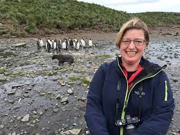
Camilla Nichol is a geologist and museum curator. Since 2014 she is the Chief Executive of the United Kingdom Antarctic Heritage Trust.

International competition extended to the continent of Antarctica during the World War II era, though the region saw no combat. During the prelude to war, Nazi Germany organised the 1938 Third German Antarctic Expedition to preempt Norway's claim to Queen Maud Land. The expedition served as the basis for a new German claim, called New Swabia. A year later, the United States Antarctic Service Expedition established two bases, which operated for two years before being abandoned. Responding to these encroachments, and taking advantage of Europe's wartime turmoil, the nearby nations of Chile and Argentina made their own claims. In 1940 Chile proclaimed the Chilean Antarctic Territory in areas already claimed by Britain, while Argentina proclaimed Argentine Antarctica in 1943 in an overlapping area.


