Cape Crozier

Last updated
Antarctica relief location map.jpg
Red pog.svg
Cape Crozier
Location of Cape Crozier
Antarctica
Cape Crozier is the most easterly point of Ross Island, Antarctica Ross Island Map topo-en.svg
Cape Crozier is the most easterly point of Ross Island, Antarctica

Cape Crozier ( 77°31′S169°24′E / 77.517°S 169.400°E / -77.517; 169.400 ) is the most easterly point of Ross Island in Antarctica. It was discovered in 1841 during James Clark Ross's expedition of 1839 to 1843 with HMS Erebus and HMS Terror, and was named after Commander Francis Crozier, captain of HMS Terror, one of the two ships of Ross' expedition. [1]

Contents

The extinct volcano Mount Terror, also named during the Ross expedition, rises sharply from the Cape to a height of 3,230 m (10,600 ft), [2] and the edge of the Ross Ice Shelf (formerly known as the Barrier or Great Ice Barrier) stretches away to its east.

History

First landing, 1902

The first landing at Cape Crozier was on 22 January 1902, during Captain Scott's Discovery Expedition. A party from RRS Discovery landed by small boat on a stony beach area a little to the west of the Cape. Scott, Edward Wilson and Charles Royds climbed the slope to a vantage point from which they could view the Barrier surface, and they were also able to observe the large Adelie penguin colony which inhabited the surrounding ice-free terrain.

Historic site

A message box was erected that day, prominently marked, for messages to be collected by any future relief ship. At the time it held a metal message cylinder, which has since been removed. The site has been designated a Historic Site or Monument (HSM 69), following a proposal by New Zealand, Norway and the United Kingdom to the Antarctic Treaty Consultative Meeting. [3]

Terra Nova Expedition, 1910–13

Captain Scott seriously considered Cape Crozier as the base for his second Antarctic expedition. [4] On the previous trip, the Discovery had been frozen into its McMurdo Sound berth for nearly two years, and had barely escaped in February 1904, a circumstance that had led to an expensive relief operation and some opprobrium for Scott. There would be no chance of the Terra Nova being icebound in the open seas off Cape Crozier, but the unsheltered location would make landings of stores and personnel difficult, the shore base would be at the mercy of rough weather, and the land route to the Barrier surface was problematic. Scott decided to return to McMurdo Sound for his base, though to a more northerly anchorage (Cape Evans).

Winter journey, 1911

Wilson was keen to continue researching the emperor penguin embryo, and needed to obtain eggs at an early stage of incubation, which meant collecting them in the depth of the Antarctic winter. In the Zoology section of the Discovery Expedition's published Scientific Report he suggested a plan for a "winter journey" whereby these eggs could be retrieved. [5] This journey, with Captain Scott's approval, [6] was undertaken between 27 June and 2 August 1911, by Wilson, Apsley Cherry-Garrard and Henry Robertson Bowers. Cherry-Garrard later described the trek in his book, The Worst Journey in the World . In the winter darkness and extreme weather conditions the journey proved slow and hazardous, but despite mishaps three eggs were retrieved and later presented by Cherry-Garrard to the Natural History Museum. [7] Ultimately, however, their scientific value proved minimal. [8] The remains of a stone hut, constructed in July 1911 by Wilson's winter journey party, have been designated a Historic Site or Monument (HSM 21), following a proposal by New Zealand to the Antarctic Treaty Consultative Meeting. [9]

Restricted site

Cape Crozier has a large Adelie penguin population CAPE CROZIER 14.jpg
Cape Crozier has a large Adélie penguin population

Cape Crozier is within a restricted area and permission is required to visit it. Cape Crozier is home to one of the largest Adélie penguin colonies in the world (~270,000 breeding pairs as of 2012), [10] one of the two southernmost emperor penguin colonies (>1900 breeding pairs as of 2018), [11] and one of the largest south polar skua colonies in the world (~1,000 breeding pairs). [12] It also hosts several species of lichens, including at least three not previously found in this part of Antarctica. [13] It has been designated an Antarctic Specially Protected Area (ASPA 124), [14] and designated an Important Bird Area (IBA) by BirdLife International. [15] From 2001 to 2005, two enormous icebergs known as Iceberg B-15 and C16 were present near shore and affected the Adelie and Emperor penguin colonies. [16] [17]

Named features

Map all coordinates using: OpenStreetMap
Ross Island. Cape Crozier in the east RossIslandMap.jpg
Ross Island. Cape Crozier in the east

Named features around Cape Crozier include Wood Point, Williamson Rock, Post Office Hill, Topping Cone, The Knoll, Kyle Cone, Bomb Peak and Igloo Spur. [18]

Wood Point

77°25′S168°57′E / 77.417°S 168.950°E / -77.417; 168.950 . A point on the north coast of Ross Island, 10 nautical miles (19 km; 12 mi) east-southeast of Cape Tennyson. Named by the United States Advisory Committee on Antarctic Names (US-ACAN) in 1964 for Robert C. Wood, United States Antarctic Research Program (USARP) biologist who carried on investigations at nearby Cape Crozier in the summer seasons 1961-62, 1962–63, and 1963–64. [19]

Williamson Rock

77°27′S169°15′E / 77.450°S 169.250°E / -77.450; 169.250 . A rock lying 4 nautical miles (7.4 km; 4.6 mi) northwest of Cape Crozier, close off the north coast of Ross Island. Charted by the British Antarctic Expedition, 1910–13, under Scott. Named for Thomas S. Williamson, who as able seaman and petty officer accompanied Scott's expeditions of 1901-04 and 1910-13. [20]

Igloo Spur

77°33′S169°16′E / 77.550°S 169.267°E / -77.550; 169.267 . A small, isolated spur 160 metres (520 ft) high high at the culmination of the general ridge extending southeast from Bomb Peak. Mapped and so named by the NZGSAE, 1958–59, because it was on this feature that Doctor E.A. Wilson and his party built a stone igloo during the British Antarctic Expedition, 1910-13. [21]

Kaminuma Bluff

77°36′S168°57′E / 77.6°S 168.95°E / -77.6; 168.95 . A bold ice-covered bluff that rises to over 200 metres (660 ft) high near the shore in southeast Ross Island. The bluff is midway between Cape Mackay and Cape Crozier. At the suggestion of P.R. Kyle, named by Advisory Committee on Antarctic Names (US-ACAN) (2000) after Katsutada Kaminuma, National Institute of Polar Research, Japan, who was a founding member of the International Mount Erebus Seismic Study (IMESS), 1980-81 through 1986. This was a joint project with the United States, Japan, and New Zealand. Kaminuma was the lead Japanese member and continued to work in Antarctica and on Mount Erebus for many years. [22]

Related Research Articles

<span class="mw-page-title-main">Adélie penguin</span> Species of bird

The Adélie penguin is a species of penguin common along the entire coast of the Antarctic continent, which is the only place where it is found. It is the most widespread penguin species, and, along with the emperor penguin, is the most southerly distributed of all penguins. It is named after Adélie Land, in turn, named for Adèle Dumont d'Urville, who was married to French explorer Jules Dumont d'Urville, who first discovered this penguin in 1840. Adélie penguins obtain their food by both predation and foraging, with a diet of mainly krill and fish.

<span class="mw-page-title-main">Ross Island</span> Island in Ross Sea, Antarctica

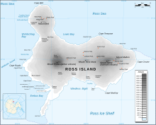
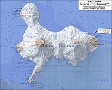
Ross Island is an island formed by four volcanoes in the Ross Sea near the continent of Antarctica, off the coast of Victoria Land in McMurdo Sound. Ross Island lies within the boundary of Ross Dependency, an area of Antarctica claimed by New Zealand.

<span class="mw-page-title-main">Mount Terror (Antarctica)</span> Shield volcano in Antarctica

Mount Terror is an extinct volcano about 3,230 metres (10,600 ft) high on Ross Island, Antarctica, about 20 nautical miles eastward of Mount Erebus. Mount Terror was named in 1841 by Sir James Clark Ross for his second ship, HMS Terror. The captain of Terror was Francis Crozier, a close friend of Ross for whom the nearby Cape Crozier is named.

<span class="mw-page-title-main">Edward Wilson (explorer)</span> English polar explorer (1872–1912)

Edward Adrian Wilson was an English polar explorer, ornithologist, natural historian, physician and artist.

<span class="mw-page-title-main">Apsley Cherry-Garrard</span> English polar explorer (1886–1959)

Apsley George Benet Cherry-Garrard was an English explorer of Antarctica. He was a member of the Terra Nova expedition and is acclaimed for his 1922 account of this expedition, The Worst Journey in the World.

<span class="mw-page-title-main">McMurdo Sound</span> Geographic location

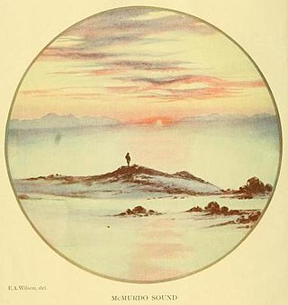
The McMurdo Sound is a sound in Antarctica, known as the southernmost passable body of water in the world, located approximately 1,300 kilometres (810 mi) from the South Pole.

<span class="mw-page-title-main">Antarctic Sound</span> Body of water in Antarctica

The Antarctic Sound is a body of water about 30 nautical miles long and from 7 to 12 nautical miles wide, separating the Joinville Island group from the northeast end of the Antarctic Peninsula. The sound was named by the Swedish Antarctic Expedition under Otto Nordenskjöld for the expedition ship Antarctic which in 1902, under the command of Carl Anton Larsen, was the first vessel to navigate it. Since 1998 cruise ships have been visiting the area.

<span class="mw-page-title-main">Cape Denison</span> Headland of Antarctica

Cape Denison is a rocky point at the head of Commonwealth Bay in George V Land, Antarctica. It was discovered in 1912 by the Australasian Antarctic Expedition (1911–14) under Douglas Mawson, who named it for Sir Hugh Denison of Sydney, a patron of the expedition. The cape was the site of the expedition's main base. Called by Mawson "the windiest place on Earth", the site experiences fierce katabatic winds.

<span class="mw-page-title-main">Francis Crozier</span> Irish naval officer and polar explorer (1796–1848?)

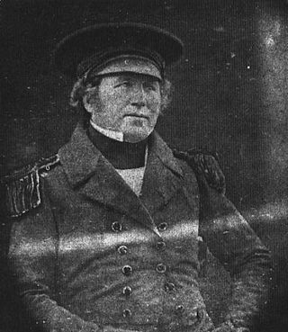
Francis Rawdon Moira Crozier was an Irish officer of the Royal Navy and polar explorer who participated in six expeditions to the Arctic and Antarctic. In May 1845, he was second-in-command to Sir John Franklin and captain of HMS Terror during the Franklin expedition to discover the Northwest Passage, which ended with the loss of all 129 crewmen in mysterious circumstances.

<i>Discovery</i> Expedition British scientific expedition to Antarctica (1901 to 1904)

The DiscoveryExpedition of 1901–1904, known officially as the British National Antarctic Expedition, was the first official British exploration of the Antarctic regions since the voyage of James Clark Ross sixty years earlier (1839–1843). Organized on a large scale under a joint committee of the Royal Society and the Royal Geographical Society (RGS), the new expedition carried out scientific research and geographical exploration in what was then largely an untouched continent. It launched the Antarctic careers of many who would become leading figures in the Heroic Age of Antarctic Exploration, including Robert Falcon Scott who led the expedition, Ernest Shackleton, Edward Wilson, Frank Wild, Tom Crean and William Lashly.

<i>Terra Nova</i> Expedition 1910–13 British Antarctic expedition

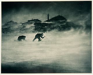
The Terra NovaExpedition, officially the British Antarctic Expedition, was an expedition to Antarctica which took place between 1910 and 1913. Led by Captain Robert Falcon Scott, the expedition had various scientific and geographical objectives. Scott wished to continue the scientific work that he had begun when leading the Discovery Expedition from 1901 to 1904, and wanted to be the first to reach the geographic South Pole.

<span class="mw-page-title-main">George Murray Levick</span> British explorer and naval surgeon (1876–1956)

George Murray Levick was a British Antarctic explorer, naval surgeon and founder of the Public Schools Exploring Society.

<i>The Worst Journey in the World</i> Memoir by Apsley Cherry-Garrard

The Worst Journey in the World is a 1922 memoir by Apsley Cherry-Garrard of Robert Falcon Scott's Terra Nova expedition to the South Pole in 1910–1913. It has earned wide praise for its frank treatment of the difficulties of the expedition, the causes of its disastrous outcome, and the meaning of human suffering under extreme conditions.

<span class="mw-page-title-main">Cape Adare</span> Peninsula of East Antarctica

Cape Adare is a prominent cape of black basalt forming the northern tip of the Adare Peninsula and the north-easternmost extremity of Victoria Land, East Antarctica.

<span class="mw-page-title-main">Erebus Ice Tongue</span>

The Erebus Ice Tongue is a mountain outlet glacier and the seaward extension of Erebus Glacier from Ross Island. It projects 11 kilometres (6.8 mi) into McMurdo Sound from the Ross Island coastline near Cape Evans, Antarctica. The glacier tongue varies in thickness from 50 metres (160 ft) at the snout to 300 metres (980 ft) at the point where it is grounded on the shoreline. Explorers from Robert F. Scott's Discovery Expedition (1901–1904) named and charted the ice tongue.

Minna Bluff is a rocky promontory at the eastern end of a volcanic Antarctic peninsula projecting deep into the Ross Ice Shelf at 78°31′S166°25′E. It forms a long, narrow arm which culminates in a south-pointing hook feature, and is the subject of research into Antarctic cryosphere history, funded by the National Science Foundation, Office of Polar Programs.

The Worst Journey in the World is a 2007 BBC Television docudrama based on the memoir of the same name by polar explorer Apsley Cherry-Garrard. Narrator Barry Letts, best known for his tenure as the producer of Doctor Who, played Cherry-Garrard in the 1948 film Scott of the Antarctic.

<i>Southern Cross</i> Expedition 1898–1900 research expedition to Antarctica

The Southern CrossExpedition, otherwise known as the British Antarctic Expedition, 1898–1900, was the first British venture of the Heroic Age of Antarctic Exploration, and the forerunner of the more celebrated journeys of Robert Falcon Scott and Ernest Shackleton. The brainchild of the Anglo-Norwegian explorer Carsten Borchgrevink, it was the first expedition to over-winter on the Antarctic mainland, the first to visit the Great Ice Barrier—later known as the Ross Ice Shelf—since Sir James Clark Ross's groundbreaking expedition of 1839 to 1843, and the first to effect a landing on the Barrier's surface. It also pioneered the use of dogs and sledges in Antarctic travel.

The Kyle Hills are a prominent group of volcanic cones, hills, ridges, and peaks that occupy the eastern part of Ross Island, Antarctica, between Mount Terror and Cape Crozier. The hills extend east–west for 8 nautical miles (15 km), rising from sea level at Cape Crozier to about 2,600 metres (8,500 ft) in Mount McIntosh at the western end of the group. Local relief of features is on the order of 200 metres (660 ft).

<span class="mw-page-title-main">Jean Pennycook</span> American educator and penguin researcher

Jean Pennycook is an American educator and zoologist specializing in Antarctic Adélie penguins. She is based in Cape Royds, an Antarctic Specially Protected Area which hosts a stable population of Adélie penguins.

References

  1. Alberts 1995, p. 164.
  2. Edward Wilson's Discovery diary: Map p290 estimates height @ 10,775 ft
  3. "List of Historic Sites and Monuments approved by the ATCM (2012)" (PDF). Antarctic Treaty Secretariat. 2012. Retrieved 2014-01-05.
  4. Scott's Last Expedition Vol 1 pp17-18
  5. Seaver, pp 247-48
  6. Scott's Last Expedition, Vol 1 p334
  7. Cherry-Garrard, Worst Journey pp351-53
  8. "Discover | Natural History Museum". Nhm.ac.uk. Retrieved 2015-08-26.
  9. "List of Historic Sites and Monuments approved by the ATCM (2012)" (PDF). Antarctic Treaty Secretariat. 2012. Retrieved 2013-10-27.
  10. Lyver, P. O.; Barron, M.; Barton, K. J.; Ainley, D. G.; Pollard, A.; Gordon, S.; McNeill, S.; Ballard, G.; Wilson, P. R. (2014). "Trends in the Breeding Population of Adelie Penguins in the Ross Sea, 1981-2012: A Coincidence of Climate and Resource Extraction Effects". PLOS ONE. 9 (3): e91188. doi: 10.1371/journal.pone.0091188 . PMC   3951313 . PMID   24621601.
  11. Schmidt, Annie E.; Ballard, Grant (2020). "Significant chick loss after early fast ice breakup at a high-latitude emperor penguin colony". Antarctic Science. 32 (3): 180–185. Bibcode:2020AntSc..32..180S. doi: 10.1017/S0954102020000048 . S2CID   213566527.
  12. "SCAR Bulletin". Scar.org. Archived from the original on 2014-07-18. Retrieved 2015-08-26.
  13. "Additions to the lichen flora of Victoria Land, Antarctica". Polish Polar Research. 2011. Retrieved 2020-12-29.
  14. "Cape Crozier, Ross Island" (PDF). Management Plan for Antarctic Specially Protected Area No. 124: Measure 7, Annex. Antarctic Treaty Secretariat. 2008. Retrieved 2013-06-12.
  15. "Cape Crozier". BirdLife Data Zone. BirdLife International. 2015. Retrieved 27 October 2020.
  16. Kooyman, Gerald L.; Ainley, David G.; Ballard, Grant; Ponganis, Paul. J. (2007). "Effects of giant icebergs on two emperor penguin colonies in the Ross Sea, Antarctica". Antarctic Science. 19 (1): 31–38. doi: 10.1017/S0954102007000065 .
  17. Shepherd, L.D.; Millar, C.D.; Ballard, G.; Ainley, D.G.; Wilson, P.R.; Haynes, G.D.; Baroni, C.; Lambert, D.M. (2005). "Microevolution and mega-icebergs in the Antarctic". Proceedings of the National Academy of Sciences of the United States of America. 102 (46): 16717–16722. doi: 10.1073/pnas.0502281102 . PMC   1283793 .
  18. Ross Island USGS.
  19. Alberts 1995, p. 822.
  20. Alberts 1995, p. 816.
  21. Alberts 1995, p. 359.
  22. Kaminuma Bluff USGS.

Sources

PD-icon.svg This article incorporates public domain material from websites or documents of the United States Geological Survey .

Bibliography