| Lewis Bay | |
|---|---|
 Lewis Bay | |
| Location | Ross Island, Antarctica |
| Coordinates | 77°20′S167°31′E / 77.333°S 167.517°E |
| Basin countries | Antarctica |
Lewis Bay is a bay indenting the north coast of Ross Island, Antarctica, between Mount Bird and Cape Tennyson. [1]
| Lewis Bay | |
|---|---|
| Lewis Bay | |
| Location | Ross Island, Antarctica |
| Coordinates | 77°20′S167°31′E / 77.333°S 167.517°E |
| Basin countries | Antarctica |
Lewis Bay is a bay indenting the north coast of Ross Island, Antarctica, between Mount Bird and Cape Tennyson. [1]
The bay was charted by the British National Antarctic Expedition under Robert Falcon Scott, 1901–04. It was named by the Advisory Committee on Antarctic Names in 1964 for Captain Price Lewis, commanding officer of the USS Staten Island (AGB-5) during the US Navy's Operation Deep Freeze in 1959, and who in 1963 and 1964 was assistant chief of staff and ship group commander of the United States Naval Support Force in Antarctica. [2]
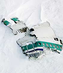
On 28 November 1979 an Air New Zealand aircraft carrying 257 people on a sightseeing flight to Antarctica crashed on the side of Mount Erebus, killing everyone aboard and scattering bodies and aircraft debris on the slopes above the bay. Not all the bodies were subsequently recovered. [3]
An area above Lewis Bay, on the lower slopes of Mount Erebus and extending to the coast, is protected as Antarctic Specially Protected Area No.156 because it has been declared a tomb in order to ensure that the area be left in peace. The declaration was made as a mark of respect and sympathy with the relatives of those who died in the 1979 crash, and with the Government and people of New Zealand, in remembrance and in order to protect the site's emotional values. [3]
A stainless steel cross was erected in January 1987 on a rocky promontory 3 km from the 1979 crash site as a mark of respect and in remembrance of those who died. The cross has been designated a Historic Site or Monument (HSM 73), following a proposal by New Zealand to the Antarctic Treaty Consultative Meeting. [4]
77°22′S168°18′E / 77.367°S 168.300°E . A rock cape on the north coast of Ross Island, about 25 nautical miles (46 km; 29 mi) southeast of Cape Bird. Discovered in February 1900 by the British Antarctic Expedition, 1898–1900 under Carsten Borchgrevink, and named by him for English poet Alfred, Lord Tennyson. [5]
77°23′00″S168°04′00″E / 77.3833333°S 168.0666667°E . A rock point 3 nautical miles (5.6 km; 3.5 mi) west-southwest of Cape Tennyson on the north side of Ross Island. In association with the names of expedition ships grouped on this island, named after United States Naval Ship (United States NavyS) Wyandot, a transport ship that carried supplies to this area in at least 13 seasons, 1955-56 to 1971-72. [6]

The Ross Dependency is a region of Antarctica defined by a sector originating at the South Pole, passing along longitudes 160° east to 150° west, and terminating at latitude 60° south. It is claimed by New Zealand, a claim accepted only by the other six countries with territorial claims in Antarctica. Under the 1961 Antarctic Treaty, of which all territorial claimants are signatories, including New Zealand, all claims are held in abeyance. Article IV states: "No acts or activities taking place while the present Treaty is in force shall constitute a basis for asserting, supporting or denying a claim to territorial sovereignty in Antarctica or create any rights of sovereignty in Antarctica".

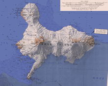
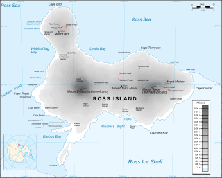
Ross Island is an island in Antarctica lying on the east side of McMurdo Sound and extending 43 nautical miles from Cape Bird on the north to Cape Armitage on the south, and a like distance from Cape Royds on the west to Cape Crozier on the east. The island is entirely volcanic. Mount Erebus, 3,795 metres (12,451 ft), near the center, is an active volcano. Mount Terror, 3,230 metres (10,600 ft), about 20 nautical miles eastward, is an extinct volcano. Mount Bird rises to 1,765 metres (5,791 ft) just south of Cape Bird. Ross Island lies within the boundary of Ross Dependency, an area of Antarctica claimed by New Zealand.

Mount Erebus is the second-highest volcano in Antarctica, the highest active volcano in Antarctica, and the southernmost active volcano on Earth. It is the sixth-highest ultra mountain on an island, and the second-highest in Antarctica. It has a summit elevation of 3,794 metres (12,448 ft). It is located in the Ross Dependency on Ross Island, which is also home to three inactive volcanoes: Mount Terror, Mount Bird, and Mount Terra Nova. The mountain was named by Captain James Clark Ross in 1841 for his ship, the Erebus.

Mount Terror is an extinct volcano about 3,230 metres (10,600 ft) high on Ross Island, Antarctica, about 20 nautical miles eastward of Mount Erebus. Mount Terror was named in 1841 by Sir James Clark Ross for his second ship, HMS Terror. The captain of Terror was Francis Crozier, a close friend of Ross for whom the nearby Cape Crozier is named.

The McMurdo Sound is a sound in Antarctica, known as the southernmost passable body of water in the world, located approximately 1,300 kilometres (810 mi) from the South Pole.

Terra Nova Bay is a bay which is often ice free, about 40 nautical miles long, lying between Cape Washington and the Drygalski Ice Tongue along the coast of Victoria Land, Antarctica. It was discovered by the British National Antarctic Expedition under Robert Falcon Scott, 1901–1904, and named by him after Terra Nova, one of the relief ships for the expedition.

Castle Rock is a bold rock crag, 415 metres (1,362 ft) high, standing 3 nautical miles northeast of Hut Point on the central ridge of Hut Point Peninsula, Ross Island, Antarctica. It was discovered by the British National Antarctic Expedition, 1901–04, under Robert Falcon Scott, who so named it because of its shape. The feature was a landmark for sledging parties returning from journeys to the south.

Hut Point Peninsula is a long, narrow peninsula from 2 to 3 nautical miles wide and 15 nautical miles long, projecting south-west from the slopes of Mount Erebus on Ross Island, Antarctica. McMurdo Station (US) and Scott Base (NZ) are Antarctic research stations located on the Hut Point Peninsula.
Mount Bird is a 1,765 metres (5,791 ft) high shield volcano standing about 7 nautical miles south of Cape Bird, the northern extremity of Ross Island. It was mapped by the British National Antarctic Expedition, 1901–04, under Robert Falcon Scott, and apparently named by them after Cape Bird.

Cape Evans is a rocky cape on the west side of Ross Island, Antarctica, forming the north side of the entrance to Erebus Bay.
Cape Royds is a dark rock cape forming the western extremity of Ross Island, facing on McMurdo Sound, Antarctica. It was discovered by the British National Antarctic Expedition (BrNAE) (1901–1904) and named for Lieutenant Charles Royds, Royal Navy, who acted as meteorologist on the expedition. Royds subsequently rose to become an Admiral and was later Commissioner of the Metropolitan Police, London. This cape was the site of Shackleton's Hut, the expedition camp of the British Antarctic Expedition, 1907–09.
Cape Crozier is the most easterly point of Ross Island in Antarctica. It was discovered in 1841 during James Clark Ross's expedition of 1839 to 1843 with HMS Erebus and HMS Terror, and was named after Commander Francis Crozier, captain of HMS Terror, one of the two ships of Ross' expedition.
The Kyle Hills are a prominent group of volcanic cones, hills, ridges, and peaks that occupy the eastern part of Ross Island, Antarctica, between Mount Terror and Cape Crozier. The hills extend east–west for 8 nautical miles (15 km), rising from sea level at Cape Crozier to about 2,600 metres (8,500 ft) in Mount McIntosh at the western end of the group. Local relief of features is on the order of 200 metres (660 ft).

Tourism started in Antarctica by the sea in the 1960s. Air overflights started in the 1970s with sightseeing flights by airliners from Australia and New Zealand, and were resumed in the 1990s. The (summer) tour season lasts from November to March. Most of the estimated 14,762 visitors to Antarctica from 1999–2000 were on sea cruises. During the 2009 to 2010 tourist season, over 37,000 people visited Antarctica.
Windless Bight is a prominent bight that indens the south side of Ross Island, Antarctica, eastward of Hut Point Peninsula. It was named by the Winter Journey Party, led by Wilson, of the British Antarctic Expedition, 1910–13, which encountered no wind in this area. The bight is permanently frozen. It is the site of a station that monitors infrasound to detect violations of the Comprehensive Nuclear-Test-Ban Treaty.
Wohlschlag Bay is a large bay indenting the western side of Ross Island, Antarctica, and lying between Harrison Bluff and Cape Royds.
Backdoor Bay is a small bay lying at the east side of Cape Royds, along the west side of Ross Island, Antarctica.
Tramway Ridge is a ridge that rises to about 3450 m above sea level in the north-west part of the summit caldera of Mount Erebus on Ross Island, Antarctica. The ridge is formed by the levees (banks) on the side of a young lava flow. The appearance of the feature is suggestive of a set of railway or tram lines.
Erebus Bay is a bay about 13 nautical miles wide between Cape Evans and Hut Point Peninsula, on the west side of Ross Island, Antarctica.

Mount Terra Nova is a snow-covered mountain, 2,130 metres (6,990 ft) high, between Mount Erebus and Mount Terror on Ross Island in Antarctica. It was first mapped by the British National Antarctic Expedition (BrNAE) 1901–04, and named for the Terra Nova, relief ship for this expedition and the British Antarctic Expedition, 1910–13.
![]() This article incorporates public domain material from websites or documents of the United States Geological Survey .
This article incorporates public domain material from websites or documents of the United States Geological Survey .