Scullin Monolith is a crescent-shaped rock fronting the sea 6 km (3.7 mi) west of the similar Murray Monolith, and 8 km (5.0 mi) from Torlyn Mountain, in Mac. Robertson Land, Antarctica. Early in January 1930 the British Australian New Zealand Antarctic Research Expedition (BANZARE) under Douglas Mawson made an aerial flight from the ship over the area. Mawson set foot on the rock on 13 February 1931 and named it for James Scullin, Prime Minister of Australia in 1929 - 31. The rock was charted in January and February 1931 from Norwegian whale catchers exploring the coast, and named "Mount Klarius Mikkelsen" for Captain Klarius Mikkelsen, master of the whale catcher Torlyn. Mikkelsen Peak is retained as the name of the highest peak of the outcrop.

Cape Denison is a rocky point at the head of Commonwealth Bay in Antarctica. It was discovered in 1912 by the Australasian Antarctic Expedition (1911–14) under Douglas Mawson, who named it for Sir Hugh Denison of Sydney, a patron of the expedition. The cape was the site of the expedition's main base. Called by Mawson "the windiest place on Earth", the site experiences fierce katabatic winds.

Mertz Glacier is a heavily crevassed glacier in George V Coast of East Antarctica. It is the source of a glacial prominence that historically has extended northward into the Southern Ocean, the Mertz Glacial Tongue. It is named in honor of the Swiss explorer Xavier Mertz.
The Mawson Coast is that portion of the coast of Mac. Robertson Land, Antarctica, lying between William Scoresby Bay, at 59°34′E, and Murray Monolith, at 66°54′E. The coast was sighted during the British Australian New Zealand Antarctic Research Expedition (BANZARE), 1929–30, under Sir Douglas Mawson. Further exploration and landings at Cape Bruce and Scullin Monolith were made during BANZARE, 1930–31. Mawson Coast was named by the Antarctic Names Committee of Australia after Mawson in recognition of his great contribution to Antarctic exploration.

Enderby Land is a projecting land mass of Antarctica. Its shore extends from Shinnan Glacier at about 67°55′S44°38′E to William Scoresby Bay at 67°24′S59°34′E, approximately 1⁄24 of the earth's longitude. It was first documented in western and eastern literature in February 1831 by John Biscoe aboard the whaling brig Tula, and named after the Enderby Brothers of London, the ship's owners who encouraged their captains to combine exploration with sealing.

Mawson's Huts are the collection of buildings located at Cape Denison, Commonwealth Bay, in the far eastern sector of the Australian Antarctic Territory, some 3000 km south of Hobart. The buildings were erected and occupied by the Australasian Antarctic Expedition (AAE) of 1911-1914, led by geologist and explorer Sir Douglas Mawson.
Hut Point Peninsula is a long, narrow peninsula from 3 to 5 km wide and 24 km (15 mi) long, projecting south-west from the slopes of Mount Erebus on Ross Island, Antarctica. McMurdo Station (US) and Scott Base (NZ) are Antarctic research stations located on the Hut Point Peninsula.
The Humboldt Mountains are a group of mountains immediately west of the Petermann Ranges, forming the westernmost portion of the Wohlthat Mountains in Queen Maud Land, Antarctica.
Cape Evans is a rocky cape on the west side of Ross Island, Antarctica, forming the north side of the entrance to Erebus Bay.
Assender Glacier is a glacier flowing west into Spooner Bay in Enderby Land, Antarctica. It was plotted from air photos taken from Australian National Antarctic Research Expeditions aircraft in 1956, and named by the Antarctic Names Committee of Australia for Pilot Officer Ken J. Assender, RAAF, pilot at Mawson Station in 1959.
Murray Monolith is a detached part of Torlyn Mountain in Mac.Robertson Land, Antarctica. It was discovered during the British Australian New Zealand Antarctic Research Expedition (BANZARE), led by Mawson, 1929–1931, and named after Sir George Murray, Chancellor of the University of Adelaide and a patron of the expedition.

Proclamation Island is a small rocky island 2.5 nautical miles west of Cape Batterbee and close east of the Aagaard Islands of Antarctica.
The Tryne Islands are a group of numerous small Antarctic islands and rocks, about 7 km (4 mi) in extent, forming the western limit of Tryne Bay and Tryne Sound at the north-eastern end of the Vestfold Hills. The islands were mapped by Norwegian cartographers from aerial photographs taken by the Lars Christensen Expedition (1936–37) and named Trynøyane.

Buromskiy Island is a small island lying 0.6 km (0.37 mi) south of Haswell Island in the Haswell Islands of Antarctica. About 200 m long and 100 m wide, it was discovered and mapped by the Australasian Antarctic Expedition under Douglas Mawson, 1911–14. It was photographed by the Soviet expedition of 1958 and named for N.I. Buromskiy, expedition hydrographer who lost his life in the Antarctic in 1957. It lies 2.7 km north of Mabus Point, the site of Russia's Mirny Station.
Cape Wadworth is the northern extremity of Coulman Island, in the Ross Sea just off Victoria Land. Discovered 17 January 1841 by Sir James Clark Ross who named it to compliment his wife's uncle, Robert John Coulman of Wadworth Hall, Doncaster.
Cape Daly is an ice-covered promontory on the coast of Antarctica, 3 nautical miles (6 km) west of Safety Island and close southeast of the Robinson Group. It was discovered in February 1931 by the British Australian New Zealand Antarctic Research Expedition under Mawson, who named it for Senator Daly of the Australian Senate.
Port Martin, or Port-Martin, is an abandoned French research base at Cape Margerie on the coast of Adélie Land, Antarctica, as well as the name of the adjacent anchorage.
Cape Geology is a low, gravel-covered point marking the western limit of Botany Bay, in the southern part of Granite Harbour, Victoria Land, Antarctica. It was charted and named by the Western Geological Party of the Terra Nova Expedition (1910–13) who established their base there.
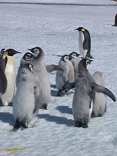
Taylor Rookery is an emperor penguin breeding colony on the Mawson Coast of Mac.Robertson Land in East Antarctica. It is the larger of the two known entirely land-based colonies of the species, most of which are situated on sea ice.


