United States Board on Geographic Names

Last updated
United States Board on Geographic Names
United States Board on Geographic Names logo.png
Board overview
FormedSeptember 4, 1890;133 years ago (1890-09-04)
Board executives
  • Marcus Allsup, Chair
  • Mike Tischler, Vice-Chair
Website www.usgs.gov/core-science-systems/ngp/board-on-geographic-names OOjs UI icon edit-ltr-progressive.svg

The United States Board on Geographic Names (BGN) is a federal body operating under the United States Secretary of the Interior. The purpose of the board is to establish and maintain uniform usage of geographic names throughout the federal government of the United States. [1] Nevertheless, its rulings and policies have been controversial from time to time.

Contents

History

On January 8, 1890, Thomas Corwin Mendenhall, superintendent of the United States Coast and Geodetic Survey Office, wrote to 10 noted geographers "to suggest the organization of a Board made up of representatives from the different Government services interested, to which may be referred any disputed question of geographical orthography." [2] President Benjamin Harrison signed executive order 28 [3] on September 4, 1890, establishing the Board on Geographical Names. [3] "To this Board shall be referred all unsettled questions concerning geographic names. The decisions of the Board are to be accepted [by federal departments] as the standard authority for such matters." [2] [3] The board was given authority to resolve all unsettled questions concerning geographic names. Decisions of the board were accepted as binding by all departments and agencies of the federal government.

The board has since undergone several name changes. [4] In 1934, it was transferred to the Department of the Interior. [4]

The Advisory Committee on Antarctic Names was established in 1943 as the Special Committee on Antarctic Names (SCAN). [5] In 1963, the Advisory Committee on Undersea Features was started for standardization of names of undersea features. [6] [7]

Its present form derives from a 1947 law, Public Law 80-242.

Operation

The 1969 BGN publication Decisions on Geographic Names in the United States stated the agency's chief purpose as:

[Names are] submitted for decisions to the Board on Geographical names by individuals, private organizations, or government agencies. It is the Board's responsibility to render formal decisions on new names, proposed changes in names, and names which are in conflict. [The decisions] define the spellings and applications of the names for use on maps and other publications of Federal agencies [4]

The board has developed principles, policies, and procedures governing the use of domestic and foreign geographic names, including underseas. [6] The BGN also deals with names of geographical features in Antarctica via its Advisory Committee on Antarctic Names.

The Geographic Names Information System, developed by the BGN in cooperation with the US Geological Survey, includes topographic map names and bibliographic references. The names of books and historic maps which confirm the feature or place name are cited. Variant names, alternatives to official federal names for a feature, are also recorded.

The BGN has members from six federal departments as well as the Central Intelligence Agency, the US Government Publishing Office, the Library of Congress, and the US Postal Service. The BGN rules on hundreds of naming decisions annually and stores over two million geographical records in its databases at geonames.usgs.gov. State and local governments and private mapping organizations usually follow the BGN's decisions.

The BGN has an executive committee and two permanent committees with full authority: the 10- to 15-member Domestic Names Committee and the 8- to 10-member Foreign Names Committee. Both comprise government employees only. Each maintains its own database. [2]

The BGN does not create place names but responds to proposals for names from federal agencies; state, local, and tribal governments; and the public. Any person or organization, public or private, may make inquiries or request the board to render formal decisions on proposed new names, proposed name changes, or names that are in conflict. Generally, the BGN defers federal name use to comply with local usage. There are a few exceptions. For example, in rare cases where a locally used name is very offensive, the BGN may decide against adoption of the local name for federal use. [8]

Special situations

The BGN does not translate terms, but instead accurately uses foreign names in the Roman alphabet. For non-Roman languages, the BGN uses transliteration systems or creates them for less well-known languages. [2]

The BGN does not recognize the use of the possessive apostrophe and has only granted an exception five times during its history, [9] including one for Martha's Vineyard, Massachusetts. [10] [11]

In federal mapping and names collection efforts, there is often a phase lag where a delay occurs in adoption of a locally used name. Sometimes the delay is several decades. Volunteers in the Earth Science Corps are used to assist the US Geological Survey in collecting names of geographic features.[ citation needed ]

Other authorities

Publications

The BGN currently publishes names on its website. In the past, the BGN issued its decisions in various publications under different titles at different intervals with various information included. [4] In 1933, the BGN published a significant consolidated report of all decisions from 1890 to 1932 in its Sixth Report of the United States Geographic Board 1890–1932. [12] For many years, the BGN published a quarterly report under the title Decisions on Geographic Names. [4]

See also

Related Research Articles

<span class="mw-page-title-main">Romanization</span> Transliteration or transcription to Latin characters

In linguistics, Romanization or romanisation is the conversion of text from a different writing system to the Roman (Latin) script, or a system for doing so. Methods of romanization include transliteration, for representing written text, and transcription, for representing the spoken word, and combinations of both. Transcription methods can be subdivided into phonemic transcription, which records the phonemes or units of semantic meaning in speech, and more strict phonetic transcription, which records speech sounds with precision.

<span class="mw-page-title-main">Geographic Names Information System</span> Geographical database

The Geographic Names Information System (GNIS) is a database of name and location information about more than two million physical and cultural features throughout the United States and its territories; the associated states of the Marshall Islands, Federated States of Micronesia, and Palau; and Antarctica. It is a type of gazetteer. It was developed by the United States Geological Survey (USGS) in cooperation with the United States Board on Geographic Names (BGN) to promote the standardization of feature names.

<span class="mw-page-title-main">Romanization of Russian</span> Romanization of the Russian alphabet

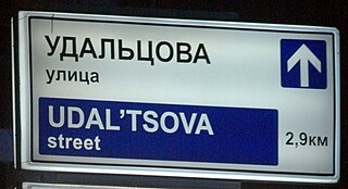
The romanization of the Russian language, aside from its primary use for including Russian names and words in text written in a Latin alphabet, is also essential for computer users to input Russian text who either do not have a keyboard or word processor set up for inputting Cyrillic, or else are not capable of typing rapidly using a native Russian keyboard layout (JCUKEN). In the latter case, they would type using a system of transliteration fitted for their keyboard layout, such as for English QWERTY keyboards, and then use an automated tool to convert the text into Cyrillic.

The romanization of Ukrainian, or Latinization of Ukrainian, is the representation of the Ukrainian language in Latin letters. Ukrainian is natively written in its own Ukrainian alphabet, which is based on the Cyrillic script. Romanization may be employed to represent Ukrainian text or pronunciation for non-Ukrainian readers, on computer systems that cannot reproduce Cyrillic characters, or for typists who are not familiar with the Ukrainian keyboard layout. Methods of romanization include transliteration and transcription.

<span class="mw-page-title-main">Ukrainian Latin alphabet</span> Latin script versions of the Ukrainian alphabet

The Ukrainian Latin alphabet is the form of the Latin script used for writing, transliteration and retransliteration of Ukrainian.

The GEOnet Names Server (GNS), sometimes also referred to in official documentation as Geographic Names Data or geonames in domain and email addresses, is a service that provides access to the United States National Geospatial-Intelligence Agency's (NGA) and the US Board on Geographic Names's (BGN) database of geographic feature names and locations for locations outside the US. The database is the official repository for the US Federal Government on foreign place-name decisions approved by the BGN. Approximately 20,000 of the database's features are updated monthly. Names are not deleted from the database, "except in cases of obvious duplication". The database contains search aids such as spelling variations and non-Roman script spellings in addition to its primary information about location, administrative division, and quality. The accuracy of the database had been criticised.

The romanization of Khmer is a representation of the Khmer (Cambodian) language using letters of the Latin alphabet. This is most commonly done with Khmer proper nouns, such as names of people and geographical names, as in a gazetteer.

<span class="mw-page-title-main">Sigsbee Deep</span> Roughly triangular basin that is the deepest part of the Gulf of Mexico

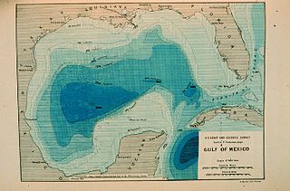
The Sigsbee Deep, is a roughly triangular basin that is the deepest part of the Gulf of Mexico named for Commander Charles Dwight Sigsbee, USN, and Assistant, United States Coast and Geodetic Survey, commanding officer of USC&GS George S. Blake, which discovered the feature during its mapping of the Gulf of Mexico. As described below there is some confusion of names that apply to the basin or a particular point in the basin with both being found in technical and popular literature applying to both basin and the coordinates.

Romanization or Latinization of Belarusian is any system for transliterating written Belarusian from Cyrillic to the Latin alphabet.

BGN/PCGN romanization are the systems for romanization and Roman-script spelling conventions adopted by the United States Board on Geographic Names (BGN) and the Permanent Committee on Geographical Names for British Official Use (PCGN).

BGN/PCGN romanization system for Russian is a method for romanization of Cyrillic Russian texts, that is, their transliteration into the Latin alphabet as used in the English language.

<span class="mw-page-title-main">Name of Pittsburgh</span> Name of the city of Pittsburgh, Pennsylvania

The name of the city of Pittsburgh, Pennsylvania, has a complicated history. Pittsburgh is one of the few U.S. cities or towns to be spelled with an h at the end of a burg suffix, although the spelling Pittsburg was acceptable for many years and was even held as standard by the federal government from 1891 to 1911.

The BGN/PCGN romanization system for Belarusian is a method for romanization of Cyrillic Belarusian texts, that is, their transliteration into the Latin alphabet.

<span class="mw-page-title-main">Antarctic Place-names Commission</span> Body affiliated with the Ministry of Foreign Affairs of Bulgaria

The Antarctic Place-names Commission was established by the Bulgarian Antarctic Institute in 1994, and since 2001 has been a body affiliated with the Ministry of Foreign Affairs of Bulgaria.

The Permanent Committee on Geographical Names (PCGN) is an independent inter-departmental body in the United Kingdom established in 1919. Its function is to establish standard names for places outside the UK, for the use of the British government. The Committee has collaborated with the Foreign Names Committee of the United States Board on Geographic Names to agree a joint romanization system, first published in 1994 as the Romanization Systems and Roman-Script Spelling Conventions.

Bindschadler Ice Stream is an ice stream between Siple Dome and MacAyeal Ice Stream. It is one of several major ice streams draining from Marie Byrd Land into the Ross Ice Shelf. The ice streams were investigated and mapped by U.S. Antarctic Research Program personnel in a number of field seasons from 1983 to 1984 and named Ice Stream A, B, C, etc., according to their position from south to north.

BGN/PCGN romanization system for Kazakh is a method for romanization of Cyrillic Kazakh texts, that is, their transliteration into the Latin alphabet as used in the English language.

BGN/PCGN romanization system for Kyrgyz is a method for romanization of Cyrillic Kyrgyz texts, that is, their transliteration into the Latin alphabet as used in the English language.

Romanization of the Burmese alphabet is representation of the Burmese language or Burmese names in the Latin alphabet.

Wolfgang Louis Gottfried Joerg, better known as W. L. G. Joerg, was an American geographer, and in particular an expert in the geography of the Arctic and Antarctic regions, who exercised broad influence on the field in various positions, ultimately as Chief Archivist of the Cartographic Records Branch of the National Archives.

References

Footnotes

  1. "The United States Board on Geographic Names: Getting the Facts Straight" (PDF). United States Board on Geographic Names. November 2016. Retrieved 27 September 2020.
  2. 1 2 3 4 Berlin, Jeremy (September 15, 2015). "Who Decides What Names Go on a Map?". National Geographic News. Archived from the original on 2015-09-20. Retrieved 2015-09-19.
  3. 1 2 3 Exec. Order No. 28 (September 4, 1890; in en)  President of the United States of America . Retrieved on 16 July 2017. Wikisource-logo.svg The full text of Executive Order 28 at Wikisource
  4. 1 2 3 4 5 Topping, Mary, comp., Approved Place Names in Virginia: An Index to Virginia Names Approved by the United States Board on Geographic Names through 1969 (Charlottesville, VA: University Press of Virginia, 1971), v–vi.
  5. Meredith F. Burrill (1990). 1890–1990, a Century of Service: United States Board on Geographic Names. U.S. Department of Agriculture, Forest Service.
  6. 1 2 "Advisory Committee on Undersea Features" Archived 2013-05-11 at the Wayback Machine Accessed 2013-10-18
  7. "Annual Report To the Secretary of the Interior Fiscal Year 2014" (PDF). Geonames. Archived (PDF) from the original on 2017-08-02. Retrieved 20 February 2019.
  8. Donald J. Orth and Roger L. Payne (2003). "Principles, Policies, and Procedures" (PDF). United States Board on Geographic Names and Domestic Geographic Names. Archived from the original (PDF) on January 8, 2016. Retrieved July 7, 2009.
  9. Apart from Martha's Vineyard: Carlos Elmer's Joshua View, Arizona; Clarke's Mountain, Oregon; Ike's Point, New Jersey; and John E's Pond, Rhode Island. "Gardens". QI. Season 7. Episode 1. November 26, 2009. (BBC Television)
  10. Newman, Barry (2013-05-16). "Theres a Question Mark Hanging Over the Apostrophes Future". Wall Street Journal . ISSN   0099-9660 . Retrieved 2020-12-14.
  11. "Obscure federal rule erased apostrophes from place names". Las Vegas Review-Journal. 2018-02-06. Retrieved 2020-12-14.
  12. "Sixth report of the United States Geographic Board: 1890 to 1932". U.S. Government Printing Office. 1933. Retrieved 17 August 2021.

Bibliography