Transport in Antarctica has transformed from explorers crossing the isolated remote area of Antarctica by foot to a more open era due to human technologies enabling more convenient and faster transport, predominantly by air and water, but also by land as well. Transportation technologies on a remote area like Antarctica need to be able to deal with extremely low temperatures and continuous winds to ensure the travelers' safety. Due to the fragility of the Antarctic environment, only a limited amount of transport movements can take place and sustainable transportation technologies have to be used to reduce the ecological footprint. The infrastructure of land, water and air transport needs to be safe and sustainable. Currently thousands of tourists and hundreds of scientists a year depend on the Antarctic transportation system.

The Antarctic Peninsula, known as O'Higgins Land in Chile and Tierra de San Martín in Argentina, and originally as Graham Land in the United Kingdom and the Palmer Peninsula in the United States, is the northernmost part of mainland Antarctica.

The South Shetland Islands are a group of Antarctic islands with a total area of 3,687 km2 (1,424 sq mi). They lie about 120 kilometres north of the Antarctic Peninsula, and between 430 and 900 km southwest of the nearest point of the South Orkney Islands. By the Antarctic Treaty of 1959, the islands' sovereignty is neither recognized nor disputed by the signatories and they are free for use by any signatory for non-military purposes.

King George Island is the largest of the South Shetland Islands, lying 120 km off the coast of Antarctica in the Southern Ocean. The island was named after King George III.

Terra Nova Bay is a bay which is often ice free, about 64 km (40 mi) long, lying between Cape Washington and the Drygalski Ice Tongue along the coast of Victoria Land, Antarctica. It was discovered by the British National Antarctic Expedition under Robert Falcon Scott, 1901–1904, and named by him after Terra Nova, one of the relief ships for the expedition. The Italian permanent Zucchelli Station is located in the bay, as is the Jang Bogo Station of South Korea. Relief Inlet can be found in the south west corner of the Bay.

The United States Antarctic Program is an organization of the United States government which has a presence in the Antarctica continent. Founded in 1959, the USAP manages all U.S. scientific research and related logistics in Antarctica as well as aboard ships in the Southern Ocean.

Admiralty Bay is an irregular bay, 8 km (5 mi) wide at its entrance between Demay Point and Martins Head, indenting the southern coast of King George Island for 16 km (10 mi), in the South Shetland Islands of Antarctica. The name appears on a map of 1822 by Captain George Powell, a British sailor, and is now established in international usage. The Henryk Arctowski Polish Antarctic Station is situated on the bay, as is the Comandante Ferraz Brazilian Antarctic Base. It has been designated an Antarctic Specially Managed Area.

The Scullin Monolith is a crescent-shaped rock fronting the sea 6 km (3.7 mi) west of the similar Murray Monolith, and 8 km (5.0 mi) from Torlyn Mountain, in Mac. Robertson Land, Antarctica. It is a steep massif of metasedimentary gneiss and granitic origin, with the adjacent coastline consisting of 40 m high ice cliffs. The monolith rises steeply to extend from 435 m high Mikkelsen Peak westward in a crescent that forms Douglas Bay.

Litchfield Island is a rocky island 0.9 kilometres (0.5 nmi) long and rising to 50 m (164 ft), lying in Arthur Harbour, 0.9 kilometres (0.5 nmi) south of Norsel Point, off the south-west coast of Anvers Island in the Palmer Archipelago of Antarctica.

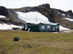
Henryk Arctowski Polish Antarctic Station is a Polish research station on King George Island, off the coast of Antarctica.
Pegasus Field was an airstrip in Antarctica, the southernmost of three airfields serving McMurdo Station. It closed due to excessive melting in the summer season caused by warmer temperatures combined with dust and dirt blown in from nearby Black Island. The last flight was on December 8, 2016 and it was replaced by Phoenix Airfield with flights expected to start in February 2017.

Henryk Arctowski, born Henryk Artzt, was a Polish scientist and explorer.

The Géologie Archipelago, also known as the Pointe Géologie Archipelago, Geology Archipelago or Cape Geology Archipelago, is a small archipelago of rocky islands and rocks close to the north of Cape Géodésie and Astrolabe Glacier Tongue, extending from Helene Island on the west to the Dumoulin Islands on the east, in Adélie Land, Antarctica.
Metchnikoff Point is a point forming the western extremity of Pasteur Peninsula in northern Brabant Island, in the Palmer Archipelago, Antarctica. It was first charted by the Third French Antarctic Expedition, 1903–05, and named by Jean-Baptiste Charcot for Russian-born zoologist and bacteriologist Élie Metchnikoff, who succeeded Louis Pasteur as the director of the Pasteur Institute in Paris.
Hawker Island is an irregularly shaped island about 2 km (1.2 mi) long, lying some 7 km south-west of Davis Station between Mule Island and Mule Peninsula, Vestfold Hills, in the eastern part of Prydz Bay, Antarctica. It was mapped by Norwegian cartographers from aerial photographs taken by the Lars Christensen Expedition, 1936–37. It was remapped by the Australian National Antarctic Research Expeditions (1957–58) and named after Alan Charles Hawker, a radio supervisor at Davis Station in 1957.
A.B. Dobrowolski Polar Station is an occasionally active Polish polar research station in Antarctica. It is located at the edge of the Algae Lake, Bunger Hills region in the Wilkes Land and was originally constructed by the Soviet Union. It is one of the two Polish stations in Antarctica, the other being the Henryk Arctowski Polish Antarctic Station.
Ann Peoples, an American anthropologist and business manager, was the first American woman to serve in a significant leadership role in Antarctica when she was appointed manager of the Berg Field Center at the McMurdo Station in 1986. She went on to manage Palmer Station from 1991 to 1995.
Firefighting in Antarctica encompasses various organizations and procedures designed to fight fires on the continent of Antarctica. Firefighting in Antarctica is complicated by the harsh conditions of the continent, the remoteness of the locations to be serviced, and the importance of protecting life-supporting shelter from immolation.
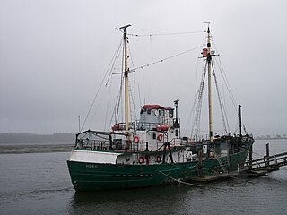
RV Hero was a research vessel that operated in Antarctica for the National Science Foundation between 1968 and 1984, after which she was laid up until she sank in 2017.
While crime in Antarctica is relatively rare, isolation and boredom affect certain people there negatively and may lead to crime. Alcoholism is a known problem on the continent, and has led to fights and indecent exposure. Other types of crimes that have occurred in Antarctica include illicit drug use, torturing and killing wildlife, racing motorbikes through environmentally sensitive areas, assault with a deadly weapon, attempted murder, and arson. Sexual harassment also has been reported.