History
In 1907, Jean-Baptiste Charcot launched a new Antarctic expedition and began work on a new ship, Pourquoi-Pas (IV), a three-masted barque designed for polar exploration, equipped with a motor and containing three laboratories and a library. It was built at Saint-Malo to plans by Francois Gautier, in his shipyard.
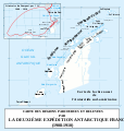
From 1908 to 1910, Charcot set out in Pourquoi-Pas, wintering at Petermann Island, on his second Antarctic polar expedition. He returned to France in 1910 laden with scientific discoveries; he had finished the mapping of Alexander Island and discovered a new island, Charcot Land.
In 1912, Pourquoi-Pas became the French Navy's first school ship. From 1918 to 1925, Charcot took Pourquoi-Pas on various scientific missions in the North Atlantic, the English Channel, the Mediterranean and the Faroe Islands, mainly to study underwater lithology and geology by means of drag nets, to whose material and use Charcot made major improvements.
From 1925 onwards, limited by age, Charcot lost command of the ship (though he remained on board as head of the expedition) for her many voyages around the Arctic glaciers. In 1926, Charcot and Pourquoi-Pas explored the eastern coast of Greenland and brought back many fossils and samples of insects and flora.
In 1928, Pourquoi-Pas set out to investigate the disappearance of the large French seaplane Latham 47 with the Norwegian explorer Roald Amundsen on board, which had itself been looking for the Italian general Umberto Nobile, who had set out to cross the North Pole in the dirigible Italia and not been heard from since.
In 1934, Charcot and Pourquoi-Pas set up an ethnographic mission in Greenland headed by Paul-Émile Victor, who spent a year in Angmagssalik living amid the Eskimo population. In 1935, Charcot and Pourquoi-Pas returned there to look for Victor and his three companions (Gessain, Pérez et Matter) and began the mapping of these regions. On 16 September that year, the ship managed to reach a small port to escape a cyclone which ravaged the coasts of Iceland.
In September 1936, returning from the mission to Greenland to deliver scientific material to Victor's mission (which had just traversed the ice sheets in 50 days) and after carrying out a survey mission, Pourquoi-Pas stopped at Reykjavík to re-provision with fuel on 13 September. They set out for Saint-Malo two days later, on 15 September, but on 16 September the ship was caught in a violent cyclonic storm and lost on the reefs of Álftanes at Mýrar. 23 of the crew were lost in the wreck and 17 survivors died before rescue came, leaving only one survivor, Eugène Gonidec, master steersman. Jean-Baptiste Charcot was one of the dead, aged 69. Pourquoi Pas Point and Pourquoi Pas Island were later named after it.

Baron Adrien Victor Joseph de Gerlache de Gomery was a Belgian officer in the Belgian Royal Navy who led the Belgian Antarctic Expedition of 1897–99.
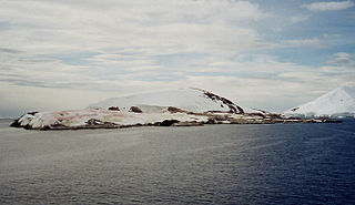
Petermann Island is a small, low and rounded island, lying off the northwest coast of Kyiv Peninsula in Graham Land, Antarctica, a short distance south of Booth Island and the Lemaire Channel. It is a popular tourist destination.
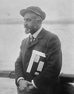
Jean-Baptiste-Étienne-Auguste Charcot, born in Neuilly-sur-Seine, was a French scientist, medical doctor and polar scientist. His father was the neurologist Jean-Martin Charcot (1825–1893).
The Mikkelsen Islands are a small group of islands and rocks lying off the southeast coast of Adelaide Island, 4 kilometres (2 nmi) southeast of the Léonie Islands. They were discovered by the French Antarctic Expedition under Jean-Baptiste Charcot in 1908–10 and named by him for Otto Mikkelsen, the Norwegian diver who inspected the damaged hull of the Pourquoi-Pas at Deception Island.
The French Antarctic Expedition is any of several French expeditions in Antarctica.
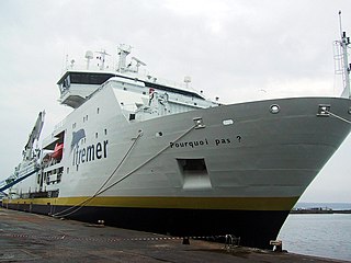
Pourquoi Pas? is a research vessel built in Saint-Nazaire, France by Alstom Marine for IFREMER and the French Navy. She is currently primarily used by SHOM. She was ordered in December 2002 and completed in July 2005. The 66 million euro cost was financed by IFREMER (55%) and the French Navy (45%). She is named after explorer Jean-Baptiste Charcot's famous ship. A space is required immediately before a question mark in French orthography, and accordingly, in French Pourquoi Pas ? is the correct way to write the name.
Bigourdan Fjord is a sound, 12 miles (19 km) long in an east-west direction and averaging 2 miles (3 km) wide, lying between Pourquoi Pas Island and the southwest part of Arrowsmith Peninsula, along the west coast of Graham Land. It was discovered by the French Antarctic Expedition, 1908–10, under Jean-Baptiste Charcot, and named by him for Guillaume Bigourdan, a noted French astronomer. It was roughly surveyed by the British Graham Land Expedition, 1934–37, under John Riddoch Rymill, and resurveyed by the Falkland Islands Dependencies Survey, 1948–50.

Laubeuf Fjord is a sound in Antarctica, 40 kilometres long in a north-south direction and averaging 16 km (10 mi) wide, lying between the east-central portion of Adelaide Island and the southern part of Arrowsmith Peninsula, Graham Land. It connects Hanusse Bay to the north with Marguerite Bay to the south. The southern 'border' between Laubeuf Fjord and Marguerite Bay is formed by the line between Rothera Point, Adelaide Island, and Cape Sáenz, which is the southernmost point of the Arrowsmith Peninsula. The fjord was discovered by the French Antarctic Expedition, 1908–10, under Jean-Baptiste Charcot, and named by him for Maxime Laubeuf, a French marine engineer who supervised building the engine for the ship Pourquoi-Pas.

Pourquoi Pas Island is a mountainous island, 27 km (17 mi) long and from 8 to 18 km wide, lying between Bigourdan Fjord and Bourgeois Fjord off the west coast of Graham Land. It was discovered by the French Antarctic Expedition under Charcot, 1908–10. The island was charted more accurately by the British Graham Land Expedition (BGLE) under John Rymill, 1934–37, who named it for Charcot's expedition ship, the Pourquoi-Pas ?.

Bourgeois Fjord is an inlet, 30 miles (50 km) long in a northeast–southwest direction and 3 to 5 miles wide, lying between the east sides of Pourquoi Pas Island and Blaiklock Island and the west coast of Graham Land. It separates Loubet Coast to the north from Fallières Coast to the south. The fjord was discovered by the French Antarctic Expedition, 1908–10, under Jean-Baptiste Charcot, and named by him for Colonel Joseph E. Bourgeois, Director of the Geographic Service of the French Army. The outline of this inlet was more accurately delineated in 1936 by the British Graham Land Expedition under John Rymill.
Pourquoi-Pas or Pourquoi Pas? may refer to one of these ships:
Sillard Islands is a group of small ice-covered islands lying close to Cape Mascart, the northeast extremity of Adelaide Island. Discovered by the French Antarctic Expedition, 1908–10, under Charcot, and named for Director Sillard of the French Montevideo Co., Montevideo, Uruguay, whose company made repairs on Charcot's ship, the Pourquoi Pas ?.
The Amiot Islands are two groups of islands and rocks, the Ward Islands and Cumbers Reef, respectively, lying 17 kilometres (9 nmi) west of Cape Adriasola, Adelaide Island, Antarctica. They were discovered by the French Antarctic Expedition, 1908–10, and were named by Jean-Baptiste Charcot for A. Amiot, engineering director of the French Montevideo Co., Montevideo, Uruguay, which made repairs on the ship Pourquoi-Pas. The islands were more accurately charted by the British Royal Navy Hydrographic Survey Unit in 1963.
Cholet Island is a small island immediately north of the narrow peninsula which forms the western extremity of Booth Island, in the Wilhelm Archipelago. It was discovered by the French Antarctic Expedition, 1903–05, under Jean-Baptiste Charcot, who named it for Ernest Cholet, skipper of the ship Français, and later, the Pourquoi-Pas?.
Deliverance Point is a rocky point 2.5 nautical miles (5 km) south of Cape Tuxen on the west coast of Graham Land. It was discovered by the French Antarctic Expedition, 1908–10, under Jean-Baptiste Charcot, and was so named because Charcot and two companions were rescued here after being separated from the ship Pourquoi-Pas? for several days, while on an exploration of the area in a small boat.
Guéguen Point is a point forming the south end of Hovgaard Island, in the Wilhelm Archipelago, Antarctica. It was charted and named by the French Antarctic Expedition, 1903–05, under Jean-Baptiste Charcot, after J. Guéguen, one of the crew the ship Français and later, of the Pourquoi Pas?, 1908–10.

Pourquoi Pas Glacier is a glacier 4 nautical miles (7 km) wide and 15 nautical miles (28 km) long, flowing north-northwest from the continental ice and terminating in a prominent tongue 9 nautical miles (17 km) west-northwest of Pourquoi Pas Point. Delineated by French cartographers from air photos taken by U.S. Navy Operation Highjump, 1946–47. Named in 1952 by the French Antarctic Sub-committee after the Pourquoi-Pas?, polar ship of the French Antarctic Expedition under Charcot, 1908–10, later used by Charcot in expeditions to Greenland.
French Passage is a passage through the Wilhelm Archipelago, extending in a northwest–southeast direction between Petermann Island, the Stray Islands, the Vedel Islands and the Myriad Islands to the north and the Argentine Islands, the Anagram Islands, the Roca Islands, and the Cruls Islands to the south. It was so named by the British Graham Land Expedition, 1934–37, because the passage was navigated for the first time in 1909 by the Pourquoi-Pas?, the ship of the French Antarctic Expedition under Jean-Baptiste Charcot. Bradley Rock is an isolated rock which lies about 9 nautical miles (17 km) northwest of the entrance to French Passage.

Scotia was a barque that was built in 1872 as the Norwegian whaler Hekla. She was purchased in 1902 by William Speirs Bruce and refitted as a research vessel for use by the Scottish National Antarctic Expedition. After the expedition, she served as a sealer, patrol vessel and collier. She was destroyed by fire in January 1916.