Related Research Articles
Svalbard is an archipelago in the Arctic Ocean roughly centered on 78° north latitude and 20° east longitude. It constitutes the northernmost territory of the Kingdom of Norway. The three main islands in the group consist of Spitsbergen, Nordaustlandet and Edgeøya. There are also a number of smaller islands, such as Barents Island (Barentsøya), Kvitøya, Prins Karls Forland, Kongsøya, Bear Island, Svenskøya, Wilhelm Island and other smaller islands or skerries.

Henry Hudson was an English sea explorer and navigator during the early 17th century, best known for his explorations of present-day Canada and parts of the northeastern United States.
William Baffin was an English navigator, explorer and cartographer. He is primarily known for his attempt to find a Northwest Passage from the Atlantic to the Pacific, during the course of which he was the first European to discover Baffin Bay situated between Canada and Greenland. He was also responsible for exceptional surveys of the Red Sea and Persian Gulf on behalf of the East India Company.
The polar archipelago of Svalbard was first discovered by Willem Barentsz in 1596, although there is disputed evidence of use by Pomors or Norsemen. Whaling for bowhead whales started in 1611, dominated by English and Dutch companies, though other countries participated. At that time there was no agreement about sovereignty. Whaling stations, the largest being Smeerenburg, were built during the 17th century, but gradually whaling decreased. Hunting was carried out from the 17th century by Pomors, but from the 19th century it became more dominated by Norwegians.

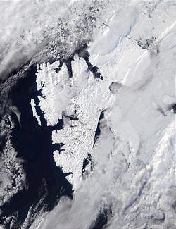
Nordaustlandet is the second-largest island in the archipelago of Svalbard, Norway, with an area of 14,443 square kilometres (5,576 sq mi). It lies north east of Spitsbergen, separated by Hinlopen Strait. Much of Nordaustlandet lies under large ice caps, mainly Austfonna and Vestfonna, the remaining parts of the north being tundra inhabited by reindeer and walruses. The island is uninhabited and lies entirely within Nordaust-Svalbard Nature Reserve.
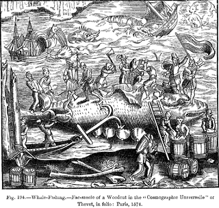
This article discusses the history of whaling from prehistoric times up to the commencement of the International Whaling Commission (IWC) moratorium on commercial whaling in 1986. Whaling has been an important subsistence and economic activity in multiple regions throughout human history. Commercial whaling dramatically reduced in importance during the 19th century due to the development of alternatives to whale oil for lighting, and the collapse in whale populations. Nevertheless, some nations continue to hunt whales even today.
Nicholas Woodcock was a 17th-century English mariner who sailed to Spitsbergen, Virginia, and Asia. He piloted the first Spanish whaling ship to Spitsbergen in 1612 and participated in the Anglo-Persian sieges of Kishm and Ormus in 1622.
Jonas Poole was an early 17th-century English explorer and sealer, and was significant in the history of whaling.

Bellsund is a 20-kilometer (12 mi) long sound on the west coast of Spitsbergen, part of the Svalbard archipelago of Norway. It is separated from Van Mijenfjorden by the islands of Akseløya and Mariaholmen. Bellsund is located south of Nordenskiöld Land and north of Wedel Jarlsberg Land.
Thomas Edge was an English merchant, whaler, and sealer who worked for the Muscovy Company in the first quarter of the 17th century. The son of Ellis Edge, Thomas Edge was born in the parish of Blackburn in Lancashire in 1587/88. Edgeøya takes its name from him. Edge's Point, the eastern point of Recherche Fjord, also commemorated his name, but is now known as Lægerneset.

Thousand Islands is a group of small islands south of Edgeøya. They form part of the Svalbard archipelago. The group consists of over forty islands and islets, including Brotskjer, Kulstadholmane, Utsira, Tufsen, Kong Ludvigøyane, Bölscheøya, Hornøya, Tiholmane, Meinickeøyane, Sletteøya, Schareholmane, Skråholmen, Brækmoholmane, Tareloppa, Vindholmen, and Menkeøyane.

Farthest North describes the most northerly latitude reached by explorers, before the first successful expedition to the North Pole rendered the expression obsolete. The Arctic polar regions are much more accessible than those of the Antarctic, as continental land masses extend to high latitudes and sea voyages to the regions are relatively short.

Heleysundet is a narrow sound between Kükenthaløya and Spitsbergen. It is known for its violent tidal races.
Tjuvfjorden is a 45 km long and up to 30 km wide fjord separating Edgeøya’s two southern promontories, Kvalpynten and Svarthuken.
Robert Fotherby was an early 17th-century English explorer and whaler. From 1613 to 1615 he worked for the Muscovy Company, and from 1615 until his death for the East India Company.
Willem Cornelisz. van Muyden was an early 17th-century mariner. He is known in the Netherlands as De Eerste Walvisvanger (1613). Van Muydenbukta and Van Mijenfjorden on the west coast of Spitsbergen and Kapp Muyen on the west coast of Jan Mayen are named after him.
Joris Carolus was a Dutch cartographer and explorer who was employed by the Noordsche Compagnie and the Dutch East India Company.
John Weddell (1583–1642) was an English sea captain who served for the Muscovy Company and then the East India Company (EIC).
William Goodlad was a 17th-century English whaler. He was admiral of the Muscovy Company's London whaling fleet for nearly two decades, participating in several of the disputes involving the right to catch whales in Spitsbergen. The Arctic explorer Luke Foxe, in writing about the early voyages to Spitsbergen, said of him: "... but this I leave to Capt. Goodlade [sic], whose great experience this way, and to the E.-ward thereof, is the best able to supply or confute, if he be pleased so to shew himselfe".
The Basques were among the first people to catch whales commercially rather than purely for subsistence and dominated the trade for five centuries, spreading to the far corners of the North Atlantic and even reaching the South Atlantic. The French explorer Samuel de Champlain, when writing about Basque whaling in Terranova, described them as "the cleverest men at this fishing". By the early 17th century, other nations entered the trade in earnest, seeking the Basques as tutors, "for [they] were then the only people who understand whaling", lamented the English explorer Jonas Poole.
References
- Conway, W. M. 1906. No Man’s Land: A History of Spitsbergen from Its Discovery in 1596 to the Beginning of the Scientific Exploration of the Country. Cambridge: At the University Press.
- Purchas, S. 1625. Hakluytus Posthumus or Purchas His Pilgrimes: Contayning a History of the World in Sea Voyages and Lande Travells by Englishmen and others. Volumes XIII and XIV (Reprint 1906 J. Maclehose and sons).