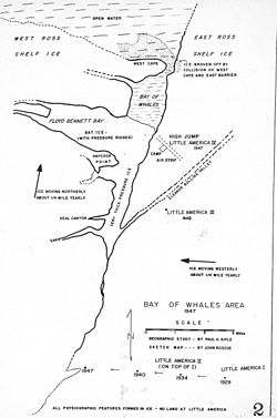
Framheim was the name of explorer Roald Amundsen's base at the Bay of Whales on the Ross Ice Shelf in Antarctica during his successful quest for the South Pole. It was used between January 1911 and February 1912.
SANAE is the South African National Antarctic Expedition. The name refers both to the overwintering bases, and the team spending the winter. The current base, SANAE IV, is located at Vesleskarvet in Queen Maud Land, Antarctica. Summer teams comprise administrative and maintenance personnel, helicopter crew and scientists from various countries and can be up to 100 people. Overwintering teams consist of scientists and support personnel from South Africa, typically totalling 10 members in recent years.
Sovetskaya was a Soviet research station in Kaiser Wilhelm II Land in Antarctica that was established on 16 February 1958 and closed on 3 January 1959.
Operation Deep Freeze is codename for a series of United States missions to Antarctica, beginning with "Operation Deep Freeze I" in 1955–56, followed by "Operation Deep Freeze II", "Operation Deep Freeze III", and so on.. Given the continuing and constant US presence in Antarctica since that date, "Operation Deep Freeze" has come to be used as a general term for US operations in that continent, and in particular for the regular missions to resupply US Antarctic bases, coordinated by the United States military. Task Force 199 was involved.

Holl Island is a rocky, triangular-shaped Antarctic island, 3.1 km (1.7 nmi) long, marking the south-western end of the Windmill Islands.
Beall Island is a rocky island with small coves indenting the eastern and western sides, lying 600 m (660 yd) south-west of the Bailey Peninsula, in the Windmill Islands on the Budd Coast of Antarctica. There are several small lakes on the island. It was first mapped from aerial photos taken by the USN's Operation Highjump and Operation Windmill in 1947 and 1948. It was named by the US-ACAN for James M. Beall, U.S. Weather Bureau observer with Operation Windmill who assisted staff aerology officers with forecasting duties. The Beall Reefs are submarine ridges with depths of less than 1.8 metres, located 1 kilometre (0.6 mi) west of the island; they were discovered at the establishment of Wilkes Station in 1961 and named by ANCA after the island. Connors Point is the north-western point of the island; it was named by the US-ACAN for Aerographer's Mate William J. Connors, USN, a member of the Wilkes Station party of 1958.

Peterson Island is a rocky island, 3.5 km (2.2 mi) long, with two inlets indenting the north side, lying west of, and separated by a narrow channel 200-400 m wide from, the Browning Peninsula, in the southern part of the Windmill Islands on the Budd Coast of Wilkes Land, Antarctica.
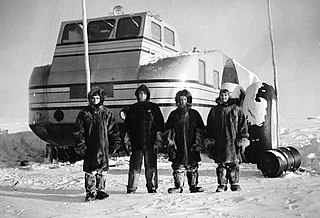
The Antarctic Snow Cruiser was a vehicle designed (1937–39) under the direction of Thomas Poulter, intended to facilitate transport in Antarctica during the United States Antarctic Service Expedition (1939–41). The Snow Cruiser was also known as "The Penguin," "Penguin 1" or "Turtle" in some published material.
Wright Island is an ice-covered island 65 km (35 nmi) long, lying at the north edge of Getz Ice Shelf about midway between Carney Island and Martin Peninsula, on the Bakutis Coast, Marie Byrd Land, Antarctica. Delineated from air photos taken by U.S. Navy Operation Highjump in January 1947. Named by Advisory Committee on Antarctic Names (US-ACAN) after Admiral Jerauld Wright, U.S. Navy, Commander in Chief, Atlantic Fleet, in over-all command of the U.S. Navy's Deep Freeze operations during the IGY, 1957–58.

The Byrd Station is a former research station established by the United States during the International Geophysical Year by U.S. Navy Seabees during Operation Deep Freeze II in West Antarctica.
O'Connor Island is a rocky island, 1.7 kilometres (1.1 mi) long, lying between Holl and Ford Islands in the southern part of the Windmill Islands of Wilkes Land, Antarctica.

Queen Maud Land is a roughly 2.7-million-square-kilometre (1.0-million-square-mile) region of Antarctica claimed by Norway as a dependent territory. It borders the claimed British Antarctic Territory 20° west and the Australian Antarctic Territory 45° east. In addition, a small unclaimed area from 1939 was annexed in June 2015. Positioned in East Antarctica, it makes out about one-fifth of the continent, and is named after the Norwegian Queen Maud (1869–1938).
Siple Station was a research station in Antarctica, established in 1973 by Stanford's STAR Lab, to perform experiments that actively probed the magnetosphere using very low frequency (VLF) waves. Its location was selected to be near the Earth's south magnetic pole, and the thick ice sheet allowed for a relatively efficient dipole antenna at VLF frequencies. John Katsufrakis of Stanford University was the "father" of the station and the VLF experiment sponsored by Stanford.
Mount King is a large, smooth-crested mountain in the eastern extremity of the Tula Mountains. Part of the Australian Antarctic Gazetteer and the SCAR Composite Gazetteer of Antarctica, it is located in Enderby Land, East Antarctica, which is claimed by Australia as part of the Australian Antarctic Territory. The head of Beaver Glacier is located very close to the base of Mount King.

Posadowsky Glacier is a glacier about 9 nautical miles long, flowing north to Posadowsky Bay immediately east of Gaussberg. Posadowsky Bay is an open embayment, located just east of the West Ice Shelf and fronting on the Davis Sea in Kaiser Wilhelm II Land. Kaiser Wilhelm II Land is the part of East Antarctica lying between Cape Penck, at 87°43'E, and Cape Filchner, at 91°54'E, and is claimed by Australia as part of the Australian Antarctic Territory. Other notable geographic features in this area include Drygalski Island, located 45 mi NNE of Cape Filchner in the Davis Sea, and Mirny Station, a Russian scientific research station.

Ellsworth Scientific Station was a permanent, all year-round originally American, then Argentine Antarctic scientific research station named after American polar explorer Lincoln Ellsworth. It was located on Gould Bay, on the Filchner Ice Shelf.
Brockton Station was an American research (weather) station in Antarctica. It was built by the Seabees and operated by the US Navy during the summer months from October 1965 to February 1972. The station was located 300 miles southeast of McMurdo Station, near the center of the Ross Ice Shelf.

International competition extended to the continent of Antarctica during the World War II era, though the region saw no combat. During the prelude to war, Nazi Germany organised the 1938 Third German Antarctic Expedition to preempt Norway's claim to Queen Maud Land. The expedition served as the basis for a new German claim, called New Swabia. A year later, the United States Antarctic Service Expedition established two bases, which operated for two years before being abandoned. Responding to these encroachments, and taking advantage of Europe's wartime turmoil, the nearby nations of Chile and Argentina made their own claims. In 1940 Chile proclaimed the Chilean Antarctic Territory in areas already claimed by Britain, while Argentina proclaimed Argentine Antarctica in 1943 in an overlapping area.
John Hobart Roscoe was an American geographer, intelligence officer and aerospace engineer. He is best known for his work with Operation Highjump and Operation Windmill, for which there was a glacier named after him.
Druzhnaya Station is any one of four different Antarctic research stations operated by the Soviet Union and later Russia from 1976 to 2013.