List of cities in Canada

Last updated

BC
AB
SK
MB
ON
QC
NB
PE
NS
NL
YT
NT
NU
Political map of Canada.png
Communities by provinces and territories of Canada

This is a list of incorporated cities in Canada, in alphabetical order categorized by province or territory. More thorough lists of communities are available for each province.

Contents

Capital cities

Geographic areaCapital
Canada Ottawa
Alberta Edmonton
British Columbia Victoria
Manitoba Winnipeg
New Brunswick Fredericton
Newfoundland and Labrador St. John's
Nova Scotia Halifax
Ontario Toronto
Prince Edward Island Charlottetown
Quebec Quebec City
Saskatchewan Regina
Northwest Territories Yellowknife
Nunavut Iqaluit
Yukon Whitehorse

Alberta

Distribution of Alberta's 19 cities and 12 other communities eligible for city status Alberta's Cities.png
Distribution of Alberta's 19 cities and 12 other communities eligible for city status

To qualify as a city in Alberta, a sufficient population size (10,000 people or more) must be present and a majority of the buildings must be on parcels of land less than 1,850 square metres (19,900 sq ft). [1] A community is not always incorporated as a city even if it meets these requirements. The urban service areas of Fort McMurray and Sherwood Park are hamlets recognized as equivalents of cities, but remain unincorporated. Ten towns are also eligible for city status but remain incorporated as towns.

Alberta has 19 cities. Beaumont is Alberta's newest city, incorporating from town status on January 1, 2019. [2]

Name Region Incorporation
date (city) [3]
Council
size [3]
2021 Census of Population [4]
Population
(2021)
Population
(2016)
Change
(%)
Land
area
(km2)
Population
density
(per km2)
Airdrie Calgary Metro Jan 1, 1985774,10061,581+20.3%84.39878.1
Beaumont [AB 1] Edmonton Metro Jan 1, 2019720,88817,457+19.7%24.70845.7
Brooks [AB 2] Southern Sep 1, 2005714,92414,451+3.3%18.21819.5
Calgary [AB 3] Calgary Metro Jan 1, 1894151,306,7841,239,220+5.5%820.621,592.4
Camrose Central Jan 1, 1955918,77218,742+0.2%41.67450.5
Chestermere [AB 4] Calgary Metro Jan 1, 2015722,16319,887+11.4%32.83675.1
Cold Lake North Oct 1, 2000715,66114,976+4.6%66.61235.1
Edmonton [AB 5] Edmonton Metro Oct 8, 1904131,010,899933,088+8.3%765.611,320.4
Fort Saskatchewan Edmonton Metro Jul 1, 1985727,08824,169+12.1%56.50479.4
Grande Prairie Northern Jan 1, 1958964,14163,166+1.5%132.71483.3
Lacombe Central Sep 5, 2010713,39613,057+2.6%20.59650.6
Leduc Edmonton Metro Sep 1, 1983734,09429,993+13.7%42.25807.0
Lethbridge Southern May 9, 1906998,40692,729+6.1%121.12812.5
Lloydminster (part) [AB 6] Central Jan 1, 1958719,73919,645+0.5%23.98823.1
Medicine Hat Southern May 9, 1906963,27163,2600.0%111.97565.1
Red Deer Central Mar 25, 19139100,844100,418+0.4%104.34966.5
Spruce Grove Edmonton Metro Mar 1, 1986737,64534,108+10.4%37.521,003.3
St. Albert Edmonton Metro Jan 1, 1977768,23265,589+4.0%47.841,426.3
Wetaskiwin [AB 7] Central May 9, 1906712,59412,655−0.5%18.75671.7
Total cities1573,023,6412,838,191+6.5%2,572.211,175.5

Notes:

  1. Beaumont is Alberta's newest city, incorporated on January 1, 2019. Based on 2016 data, Beaumont is Alberta's smallest city by land area, but in 2017 its area increased to nearly 2,400 hectares, making it larger than Wetaskiwin and Lacombe. [3]
  2. Brooks is Alberta's smallest city by land area.
  3. Calgary is Canada's third-largest city, Alberta's largest city by both population and area, and was Alberta's first city, incorporated on January 1, 1894. The Calgary census metropolitan area (CMA) includes the cities of Airdrie, Calgary and Chestermere.
  4. Chestermere was known as Chestermere Lake prior to March 1, 1993. [3]
  5. Edmonton is Canada's fifth-largest city and Alberta's capital. The Edmonton CMA includes the cities of Beaumont, Edmonton, Fort Saskatchewan, Leduc, Spruce Grove and St. Albert.
  6. The balance of Lloydminster is located within Saskatchewan.
  7. Wetaskiwin is Alberta's smallest city by population.

British Columbia

In British Columbia, a community can be incorporated as a city if its population exceeds 5,000. [5] Once so incorporated, a city does not lose this status even if its population later declines; the once-larger City of Greenwood, for example, now has a population of just 665 people.

British Columbia has 53 cities.

Notes:

  1. Vancouver is Canada's eighth-largest city and British Columbia's largest city by population. The Vancouver CMA includes the cities of Burnaby, Coquitlam, Delta, Langley, Maple Ridge, New Westminster, North Vancouver, Pitt Meadows, Port Coquitlam, Port Moody, Richmond, Surrey, Vancouver and White Rock.
  2. Victoria is British Columbia's capital. The Victoria CMA includes the cities of Colwood, Langford and Victoria.

Manitoba

Cities and towns in Manitoba Manmap.png
Cities and towns in Manitoba

A community in Manitoba may seek city status once reaching a population of 7,500. [10] Manitoba's newest city is Morden, which changed from town to city status on August 24, 2012. [10]

Manitoba has 10 cities.

Notes:

  1. Dauphin is Manitoba's smallest city by area.
  2. Flin Flon is Manitoba's smallest city by population. The balance of Flin Flon is located within Saskatchewan.
  3. This area does not include 2.37 km2 (0.92 sq mi) in the Saskatchewan portion of Flin Flon. The city's total area in 2016 was 16.24 km2 (6.27 sq mi).
  4. Morden is Manitoba's newest city, incorporated August 24, 2012.
  5. Winnipeg is Canada's seventh-largest city and Manitoba's capital and largest city by both population and area. The Winnipeg census metropolitan area (CMA) is formed around the City of Winnipeg.

New Brunswick

Cities and towns in New Brunswick New Brunswick map general.png
Cities and towns in New Brunswick

New Brunswick has eight cities:

Newfoundland and Labrador

Newfoundland and Labrador has three cities.

NamePopulation
(2016) [12]
Population
(2011) [13]
Change
(%) [13]
Area
(km²) [13]
Population
density [13]
Corner Brook [NL 1] 19,80619,886−0.4148.26133.6
Mount Pearl [NL 2] 22,95724,284−5.515.761,456.8
St. John's [NL 3] 108,860106,1722.5445.88244.1
Total cities151,623150,342−1.1609.90611.5

Notes:

  1. Corner Brook is Newfoundland and Labrador's smallest city by population.
  2. Mount Pearl is Newfoundland and Labrador's smallest city by area.
  3. St. John's is Newfoundland and Labrador's capital and largest city by both population and area. The St. John's census metropolitan area includes the cities of Mount Pearl and St. John's.

Northwest Territories

As in the other two Canadian territories, the only incorporated city in the Northwest Territories is its capital, Yellowknife.

NamePopulation
(2016) [14]
Population
(2011) [15]
Change
(%) [15]
Area
(km²) [15]
Population
density [15]
Yellowknife 19,56919,2341.7105.47185.5

Nova Scotia

Towns and former cities in Nova Scotia Nova Scotia base map.png
Towns and former cities in Nova Scotia

Nova Scotia no longer has any incorporated cities, as they were amalgamated into regional municipalities in the 1990s.

Nunavut

As in the other two Canadian territories, the only incorporated city in Nunavut is its capital, Iqaluit.

NamePopulation
(2016) [16]
Population
(2011) [17]
Change
(%) [17]
Area
(km²) [17]
Population
density [17]
Iqaluit 7,7406,69915.552.50147.4

Ontario

Ontario has 52 cities. In Ontario, city status is conferred by the provincial government, generally upon the request of the incorporated municipality. A municipality may apply for city status anytime after its population surpasses 10,000. This status is not automatically conferred on a community that reaches this population target, but must be requested by the municipality and granted by the provincial Ministry of Municipal Affairs and Housing. Not all municipalities which reach this population target have pursued city designation. For example, Ajax, Oakville, and Whitby, which all had populations greater than 100,000 in 2011, are still designated as towns. [18] Once designated a city, however, a municipality does not lose this status even if its population later falls back below 10,000 (as, for example, Dryden). Ontario's newest city is Richmond Hill, which changed from town to city status on March 25, 2019. [19]

    Prince Edward Island

    Prince Edward Island has two cities.

    Name County Population
    (2016) [23]
    Population
    (2011) [24]
    Change
    (%) [24]
    Area
    (km²) [24]
    Population
    density [24]
    Charlottetown [PE 1] Queens 36,09434,5624.444.34814.1
    Summerside [PE 2] Prince 14,82914,7510.528.49520.5
    Total cities50,92349,3132.4572.83667.3

    Notes:

    1. Charlottetown is Prince Edward Island's capital and larger city by population and area.
    2. Summerside is Prince Edward Island's smaller city by population and area.

    Quebec

    In Quebec, provincial law does not contain any cities at the current time, although the designation exists. — A ville, though legally a "township", may be informally referred to as a town or a city in English, but this is an arbitrary and subjective distinction. Quebec municipal types are cities (cités), townships (villes), and municipalités (municipalités).

    Quebec has 223 villes.

    Villes in Quebec

    Notes:

      Saskatchewan

      In Saskatchewan, Section 39(1) of The Cities Act indicates a town must have a population of 5,000 or more [25] and meet other criteria in order to incorporate as a city, although in the early 20th century several centres such as Saskatoon and Regina were granted city status despite having a smaller population. The City of Melville retains its city status despite dropping below 5,000 people in the 1990s. Kindersley has expressed an interest in applying for city status upon reaching the 5,000 milestone. [26] Saskatchewan's newest city is Warman, which changed from town to city status on October 24, 2012. [27]

      Saskatchewan has 16 cities.

      Notes:

      1. The balance of Flin Flon is located within Manitoba.
      2. This population does not include 5,363 in the Manitoba portion of Flin Flon. The city's total population in 2011 was 5,592.
      3. This area does not include 13.88 km2 (5.36 sq mi) in the Manitoba portion of Flin Flon. The city's total area in 2011 was 16.25 km2 (6.27 sq mi).
      4. The balance of Lloydminster is located within Alberta.
      5. This population does not include 18,032 in the Alberta portion of Lloydminster. The city's total population in 2011 was 27,804.
      6. This area does not include 24.19 km2 (9.34 sq mi) in the Alberta portion of Lloydminster. The city's total area in 2011 was 41.53 km2 (16.03 sq mi).
      7. Martensville is Saskatchewan's smallest city by area.
      8. Melville is Saskatchewan's smallest city by population.
      9. Regina is Saskatchewan's capital and was its first city, incorporated June 19, 1903. The Regina census metropolitan area (CMA) is formed around the City of Regina.
      10. Saskatoon is Saskatchewan's largest city by both population and area. The Saskatoon CMA includes the cities of Martensville and Saskatoon.
      11. Warman is Saskatchewan's newest city, incorporated October 27, 2012.

      Yukon

      As in the other two Canadian territories, the only incorporated city in the Yukon is its capital, Whitehorse. Dawson was also previously incorporated as a city, but when the criteria were changed in the 1980s, its status was reduced to that of a town due to population. Through special provision, however, it was officially the town of the city of Dawson until 2001. [34]

      NamePopulation
      (2016) [35]
      Population
      (2011) [36]
      Change
      (%) [36]
      Area
      (km²) [36]
      Population
      density [36]
      Whitehorse 25,08523,2767.8416.5460.2

      See also

      Explanatory notes

      1. The Barrie census metropolitan area (CMA) is formed around the City of Barrie.
      2. The Brantford CMA includes the City of Brantford as well as the County of Brant, which is a single-tier city.
      3. The City of Cambridge, as well as the cities of Kitchener and Waterloo, form parts of the Kitchener–Cambridge–Waterloo CMA.
      4. Dryden is Ontario's smallest city by population.
      5. Greater Sudbury is Ontario's largest city by area. The Greater Sudbury CMA is formed around the City of Greater Sudbury.
      6. Hamilton is Canada's tenth-largest city. The Hamilton CMA includes the cities of Burlington and Hamilton.
      7. The City of Kitchener, as well as the cities of Cambridge and Waterloo, form parts of the Kitchener–Cambridge–Waterloo CMA.
      8. The London CMA includes the cities of London and St. Thomas.
      9. Mississauga is Ontario's largest lower-tier city.
      10. The City of Niagara Falls, as well as the cities of Port Colborne, St. Catharines, Thorold and Welland, form parts of the St. Catharines–Niagara CMA.
      11. The Oshawa CMA is formed around the City of Oshawa.
      12. Ottawa is Canada's capital and fourth-largest city. The Ontario portion of the Ottawa–Gatineau CMA includes the cities of Clarence-Rockland and Ottawa.
      13. Pembroke is Ontario's smallest city by area.
      14. The Peterborough CMA is formed around the City of Peterborough.
      15. Richmond Hill is Ontario's newest city, adopting the name on March 26, 2019.
      16. The City of St. Catharines, as well as the cities of Niagara Falls, Port Colborne, Thorold and Welland, form parts of the St. Catharines–Niagara CMA.
      17. The Thunder Bay CMA is formed around the City of Thunder Bay.
      18. Toronto is Ontario's capital and Canada's and Ontario's largest city by population. The Toronto CMA includes the cities of Brampton, Markham, Mississauga, Pickering, Richmond Hill, Toronto and Vaughan.
      19. The City of Waterloo, as well as the cities of Cambridge and Kitchener, form parts of the Kitchener–Cambridge–Waterloo CMA.
      20. The Windsor CMA is formed around the City of Windsor.

      Related Research Articles

      <span class="mw-page-title-main">Flin Flon</span> City in Manitoba and Saskatchewan, Canada

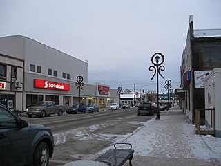
      Flin Flon is a mining city, located on a correction line on the border of the Canadian provinces of Manitoba and Saskatchewan, with the majority of the city located within Manitoba. Residents thus travel southwest into Saskatchewan, and northeast into Manitoba. The city is incorporated in and is jointly administered by both provinces.

      <span class="mw-page-title-main">Lloydminster</span> City in Alberta and Saskatchewan, Canada

      Lloydminster is a city in Canada which has the unusual geographic distinction of straddling the provincial border between Alberta and Saskatchewan. The city is incorporated by both provinces as a single city with a single municipal administration.

      <span class="mw-page-title-main">Census geographic units of Canada</span> Term used in Canada

      The census geographic units of Canada are the census subdivisions defined and used by Canada's federal government statistics bureau Statistics Canada to conduct the country's quinquennial census. These areas exist solely for the purposes of statistical analysis and presentation; they have no government of their own. They exist on four levels: the top-level (first-level) divisions are Canada's provinces and territories; these are divided into second-level census divisions, which in turn are divided into third-level census subdivisions and fourth-level dissemination areas.

      Creighton is a northern town in the Canadian province of Saskatchewan, named after Thomas Creighton. It had a 2016 census population of 1,402 inhabitants, down 0.3% from 1,498 inhabitants in 2011.

      <span class="mw-page-title-main">Division No. 18, Saskatchewan</span> Census division of Saskatchewan, Canada

      Division No. 18, Saskatchewan, Canada, is one of the eighteen Statistics Canada census divisions within the province, occupying the northern half of the province. The census division is coextensive with the Northern Saskatchewan Administration District (NSAD).

      <span class="mw-page-title-main">Demographics of Manitoba</span>

      Manitoba is one of Canada's 10 provinces. It is the easternmost of the three Prairie provinces.

      Smeaton is a village in the Canadian province of Saskatchewan within the Rural Municipality of Torch River No. 488 and Census Division No. 14. It is at the foot of Hanson Lake Road, which ends at Creighton near Flin Flon, Manitoba). Narrow Hills Provincial Park is 70 km north.

      According to the 2021 census, the City of Edmonton had a population of 1,010,899 residents, compared to 4,262,635 for all of Alberta, Canada. The total population of the Edmonton census metropolitan area (CMA) was 1,418,118, making it the sixth-largest CMA in Canada.

      <span class="mw-page-title-main">Western Canada</span> Region of Canada

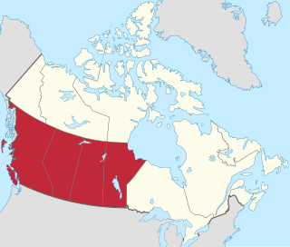
      Western Canada, also referred to as the Western provinces, Canadian West or the Western provinces of Canada, and commonly known within Canada as the West, is a Canadian region that includes the four western provinces just north of the Canada–United States border namely British Columbia, Alberta, Saskatchewan and Manitoba. The people of the region are often referred to as "Western Canadians" or "Westerners", and though diverse from province to province are largely seen as being collectively distinct from other Canadians along cultural, linguistic, socioeconomic, geographic and political lines. They account for approximately 32% of Canada's total population.

      <span class="mw-page-title-main">Demographics of Calgary</span>

      In the 2021 Census, the City of Calgary had a population of 1,306,784 residents, representing 30.7% of the 4,262,635 residents in all of Alberta, and 3.5% compared to a population of 36,991,981 in all of Canada. The total population of the Calgary census metropolitan area (CMA) was 1,481,806. Calgary is the largest city in Alberta, and the third-largest municipality and fifth-largest metropolitan area in Canada, as of 2021.

      References

      1. "Municipal Government Act – Revised Statutes of Alberta 2000, Chapter M-26 (Section 82)". Alberta Queen's Printer. January 1, 2010. Retrieved April 29, 2019.
      2. "O.C. 395/2018 – Municipal Government Act". Alberta Queen’s Printer. Government of Alberta. December 11, 2018. Archived from the original on January 2, 2019. Retrieved January 1, 2019.
      3. 1 2 3 4 "City Municipal Profiles" (PDF). Alberta Municipal Affairs. April 17, 2019. Retrieved April 17, 2019.
      4. "Population and dwelling counts: Canada, provinces and territories, and census subdivisions (municipalities), Alberta". Statistics Canada. February 9, 2022. Retrieved May 5, 2022.
      5. Government of British Columbia – Local Government Act
      6. "Order in Council No. 362". Province of British Columbia. September 22, 2017. Retrieved January 10, 2018.
      7. "Order of the Lieutenant Governor in Council: Order in Council No. 513" (PDF). Province of British Columbia. September 9, 2014. Retrieved September 14, 2014.
      8. "Order in Council 0187-2021". March 29, 2021. Retrieved March 29, 2021.
      9. "Order in Council No. 357". Province of British Columbia. June 26, 2015. Retrieved July 1, 2015.
      10. 1 2 "Morden Gets City Status". City of Morden. August 27, 2012. Archived from the original on September 23, 2012. Retrieved October 31, 2012.
      11. "Census Profile, 2021 Census of Population". Statistics Canada. February 9, 2021. Retrieved February 9, 2021.
      12. "Population and dwelling counts, for Canada, provinces and territories, and census subdivisions (municipalities), 2016 and 2011 censuses (Newfoundland and Labrador)". Statistics Canada.
      13. 1 2 3 4 "Population and dwelling counts, for Canada, provinces and territories, and census subdivisions (municipalities), 2011 and 2006 censuses (Newfoundland and Labrador)". Statistics Canada. February 8, 2012. Retrieved March 1, 2012.
      14. "Population and dwelling counts, for Canada, provinces and territories, and census subdivisions (municipalities), 2016 and 2011 censuses (Northwest Territories)". Statistics Canada.
      15. 1 2 3 4 "Population and dwelling counts, for Canada, provinces and territories, and census subdivisions (municipalities), 2011 and 2006 censuses (Northwest Territories)". Statistics Canada. February 8, 2012. Retrieved March 1, 2012.
      16. "Population and dwelling counts, for Canada, provinces and territories, and census subdivisions (municipalities), 2016 and 2011 censuses (Nunavut)". Statistics Canada.
      17. 1 2 3 4 "Population and dwelling counts, for Canada, provinces and territories, and census subdivisions (municipalities), 2011 and 2006 censuses (Nunavut)". Statistics Canada. February 8, 2012. Retrieved March 1, 2012.
      18. "Population and dwelling counts, for Canada, provinces and territories, and census subdivisions (municipalities), 2011 and 2006 censuses (Ontario)". Statistics Canada. May 28, 2012. Retrieved January 3, 2013.
      19. Wang, sheila (26 March 2019). "Richmond Hill changes status from town to city". Richmond Hill Liberal. Retrieved 13 April 2019.
      20. "List of Ontario Municipalities". Ontario Municipal Affairs and Housing. September 21, 2012. Archived from the original on February 28, 2013. Retrieved January 3, 2013.
      21. "Population and dwelling counts, for Canada, provinces and territories, and census divisions, 2011 and 2006 censuses (Ontario)". Statistics Canada. January 30, 2013. Retrieved June 27, 2013.
      22. "subdivisions (municipalities) and designated places, 2016 and 2011 censuses – 100% data". Statistics Canada.
      23. "Population and dwelling counts, for Canada, provinces and territories, and census subdivisions (municipalities), 2016 and 2011 censuses (Prince Edward Island)". Statistics Canada.
      24. 1 2 3 4 "Population and dwelling counts, for Canada, provinces and territories, and census subdivisions (municipalities), 2011 and 2006 censuses (Prince Edward Island)". Statistics Canada. January 1, 2013. Retrieved May 19, 2013.
      25. "The Cities Act (Chapter C-11.1 of The Statutes of Saskatchewan, 2002)" (PDF). Saskatchewan Queen's Printer. Retrieved June 4, 2010.
      26. "Town of Kindersley May 2011 Newsletter" (PDF). Town of Kindersley. May 2011. Archived from the original (PDF) on November 13, 2013. Retrieved May 29, 2012.
      27. "Warman joins Saskatchewan's family of cities". Government of Saskatchewan. October 27, 2012. Archived from the original on November 13, 2013. Retrieved October 31, 2012.
      28. "Search for Municipal Information". Saskatchewan Ministry of Municipal Affairs. Archived from the original on March 10, 2014. Retrieved December 16, 2012.
      29. "Urban Municipality Incorporation Dates". Archived from the original on February 25, 2012. Retrieved February 12, 2010.
      30. 1 2 3 4 Government of Canada, Statistics Canada (2022-02-09). "Select from a list of geographies - Saskatchewan". www12.statcan.gc.ca. Retrieved 2023-03-26.
      31. "Population and dwelling counts, for Canada, provinces and territories, and census subdivisions (municipalities), 2016 and 2011 censuses – 100% data". Statistics Canada. February 8, 2018. Retrieved May 22, 2018.
      32. 1 2 "Population and dwelling counts, for Canada, provinces and territories, and census subdivisions (municipalities), 2011 and 2006 censuses (Saskatchewan)". Statistics Canada. May 28, 2012. Retrieved December 16, 2012.
      33. "Corrections and updates: Population and dwelling count amendments, 2011 Census". Statistics Canada. August 13, 2013. Retrieved December 15, 2013.
      34. Kirandeep Kang (2023-01-07). "Canadian Cities Population by Provinces 2023 - canada immigration today" . Retrieved 2023-01-12.
      35. "Population and dwelling counts, for Canada, provinces and territories, and census subdivisions (municipalities), 2016 and 2011 censuses (Yukon)". Statistics Canada.
      36. 1 2 3 4 "Population and dwelling counts, for Canada, provinces and territories, and census subdivisions (municipalities), 2011 and 2006 censuses (Yukon)". Statistics Canada. February 8, 2012. Retrieved March 1, 2012.