Many of the largest dams and reservoirs in New Zealand have been developed principally to produce hydroelectricity. Other uses include irrigation and municipal water supply.
The river was developed in multiple stages. The Waitaki Dam was built first, without earthmoving machinery, followed by the development of the Aviemore Dam on Lake Aviemore and Benmore Dam on Lake Benmore. Lake Pukaki was initially dammed at this stage to provide storage and flow control. A small station was also installed on Lake Tekapo, but although it has a small dam to raise the pre-existing lake, water was taken through a 1.6km (1mi) tunnel to a powerstation below the level of the lake.
In the 1960s, work was started on the Upper Waitaki project. This project consisted of taking the discharge from the original Tekapo (A) station through a power canal, the Tekapo Canal, to Tekapo B station at the edge of Lake Pukaki. The dam at Pukaki was increased in height. Water from Pukaki is then transferred into the Pukaki Canal which meets the Ōhau Canal from Lake Ōhau into Ōhau A station and Lake Ruataniwha. The Ōhau Canal continues beyond Lake Ruataniwha to Ōhau B midway along, before emptying through Ōhau C into Lake Benmore.
Tekapo Canal
The stations are (capacity) (annual output) (commissioned)
Tekapo A (25 MW) (160 GWh) 1955
Tekapo B (160 MW) (800 GWh) 1977
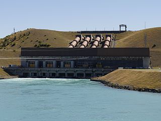
Ōhau A (264 MW) (1150 GWh) 1980
Ōhau B (212 MW) (970 GWh) 1984/1985
Ōhau C (212 MW) (970 GWh) 1984/1985
The original Waitaki power stations discharge water back into the Waitaki River which then forms a storage lake for the next station in the chain. The three power stations are:
Project Aqua was a proposed scheme of six dams on a man made canal running from the Waitaki Dam to the sea. It was cancelled by Meridian Energy on 29 March 2004.
Manapouri does not rely on a high dam to provide water – it takes advantage of the natural 178-metre height difference between Lake Manapouri and the sea at Deep Cove in Doubtful Sound, in Fiordland. The power house is in a cavern, while two tailrace tunnels take the water from the power house 10km (6mi) to Deep Cove and the sea. The Manapouri Control Structure (Mararoa dam) downstream from the original outlet of Lake Manapouri controls the lake level, and feeds water from the Mararoa river back up the river into the Lake.
↑ IPENZ Engineers New Zealand, Engineering Heritage Register,Morton Buttress Dam of 1911, retrieved 29 December 2010.
↑ IPENZ Engineers New Zealand, Engineering Heritage Register,Lower Karori Dam, retrieved 29 December 2010.
Further reading
Offer, R.E. (Robert) (1997). Walls for Water: Pioneer Dam Building in New Zealand. Palmerston North: The Dunmore Press Ltd. ISBN0-86469-313-3. Retired civil engineer and dam inspector examines the development of New Zealand dam construction techniques and uses from the 1860s to the 1950s for municipal water supply, mining, kauri logging and development of the Lake Waikarimoana Natural Dam for hydroelectric power.
Omarama is a small town at the junction of State Highways 8 and 83, near the southern end of the Mackenzie Basin, in the South Island of New Zealand. Omarama is in the Waitaki District, in the southern Canterbury region. The Ahuriri River is a short distance to the north of the township. Omarama is 30 km southwest of Twizel, 40 km southeast of Lake Ōhau and 32 km northeast of the Lindis Pass.
Benmore Dam is the largest dam within the Waitaki power scheme, located in the Canterbury Region of New Zealand's South Island. There are eight other power stations in the Waitaki Power Scheme.
Meridian Energy Limited is a New Zealand electricity generator and retailer. The company generates the largest proportion of New Zealand's electricity, generating 35 percent of the country's electricity in the year ending December 2014, and is the fourth largest retailer, with 14 percent of market share in terms of customers as of December 2015.
The Mackenzie Basin, popularly and traditionally known as the Mackenzie Country, is an elliptical intermontane basin located in the Mackenzie and Waitaki Districts, near the centre of the South Island of New Zealand. It is the largest such basin in New Zealand. Historically famous mainly for sheep farming, the sparsely populated area is now also a popular tourism destination.
The Waitaki River is a large braided river on the South Island of New Zealand. It drains the Mackenzie Basin and runs 209 kilometres (130 mi) south-east to enter the Pacific Ocean between Timaru and Oamaru on the east coast. It starts at the confluence of the Ōhau and Tekapo rivers, now at the head of the artificial Lake Benmore, these rivers being fed by three large glacial lakes, Pukaki, Tekapo, and Ōhau at the base of the Southern Alps. The Waitaki flows through Lake Benmore, Lake Aviemore and Lake Waitaki, these lakes being contained by hydroelectric dams, Benmore Dam, Aviemore Dam and Waitaki Dam. The Waitaki has several tributaries, notably the Ahuriri River and the Hakataramea River. It passes Kurow and Glenavy before entering the Pacific Ocean. The River lends its name the Waitaki District on the south side of the river bank.
Twizel is the largest town in the Mackenzie District, in the Canterbury Region of the South Island of New Zealand. The town was founded in 1968 to house construction workers on the Upper Waitaki Hydroelectric Scheme. Today, Twizel is a service and tourist town for visitors to the area. It has a resident population of 1,850 ; during the summer, holidaymakers nearly triple the town's population.
Lake Benmore is New Zealand's largest artificial lake. Located in the South Island of New Zealand and part of the Waitaki River, it was created in the 1960s by construction of Benmore Dam.
Lake Ruataniwha is an artificial lake in the Mackenzie Basin in the South Island of New Zealand. It was formed in 1977–1981 as part of the Waitaki hydroelectric project. It lies on the traditional boundary of the Canterbury and Otago provinces, with the town of Twizel two kilometres to the north.
Lake Ōhau is a lake in the Mackenzie Basin in the South Island of New Zealand. The Hopkins and Dobson rivers fed into the northern end of Lake Ōhau. These rivers have their headwaters in the Southern Alps / Kā Tiritiri o te Moana. The lake's outflow is the Ōhau River, which travels from the southeast corner of Lake Ōhau and feeds into the Waitaki River hydroelectric project. The Barrier range dominate the western side of Lake Ōhau, while the Ben Ohau range dominates the eastern side of Lake Ōhau. At the northern end of the lake, in between the Hopkins and Dobson rivers, lies the Naumann Range of mountains.
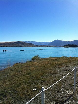
Lake Pukaki is the largest of three roughly parallel alpine lakes running north–south along the northern edge of the Mackenzie Basin on New Zealand's South Island. The others are Lakes Tekapo and Ōhau. All three lakes were formed when the terminal moraines of receding glaciers blocked their respective valleys, forming moraine-dammed lakes. The Alps2Ocean mountain bike trail follows the edge of Lake Pukaki for part of its length.
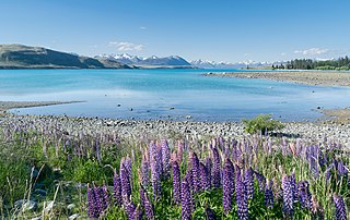
Lake Tekapo is the second-largest of three roughly parallel lakes running north–south along the northern edge of the Mackenzie Basin in the South Island of New Zealand. It covers an area of 83 square kilometres (32 sq mi) and is at an altitude of 710 metres (2,330 ft) above sea level.
The Tekapo River flows occasionally through the Mackenzie Basin, Canterbury, in New Zealand's South Island, although the riverbed is now often dry in the upper reaches. It maintains a constant flow below the confluence of several tributaries, notably the Maryburn, Forks, and Grays rivers.
The Pukaki River flows through the Mackenzie Basin, Canterbury, in New Zealand's South Island.
The New Zealand Ministry of Works and Development, formerly the Department of Public Works and often referred to as the Public Works Department or PWD, was founded in 1876 and disestablished and privatised in 1988. The Ministry had its own Cabinet-level responsible minister, the Minister of Works or Minister of Public Works.
The electricity sector in New Zealand uses mainly renewable energy, such as hydropower, geothermal power and increasingly wind energy. As of 2019, 82% of electricity is generated from renewable sources, making New Zealand one of the countries with the lowest carbon dioxide emissions from electricity generation. Electricity demand grew by an average of 2.1% per year from 1974 to 2010 but decreased by 1.2% from 2010 to 2013.
Hydroelectric power in New Zealand has been a part of the country's energy system for over 100 years and continues to provide more than half of the country's electricity needs. Hydroelectricity is the primary source of renewable energy in New Zealand. Power is generated the most in the South Island and is used most in the North Island.
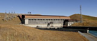
Ōhau A is a power station operated by Meridian Energy in the South Island of New Zealand.
Ōhau B is a power station operated by Meridian Energy in the South Island of New Zealand.
The Alps 2 Ocean Cycle Trail is a cycle trail. This trail is one of the projects of the New Zealand Cycle Trail. The trail extends more than 300 kilometres (190 mi) from Aoraki / Mount Cook to Oamaru on the Pacific Ocean. From west to east, it descends from an altitude of 780 metres (2,560 ft) down to sea level. The trail has both on and off-road sections.
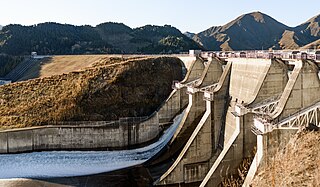
The Waitaki Dam is one of eight hydroelectric power stations which form the Waitaki hydroelectric scheme on the Waitaki River in the Canterbury Region of New Zealand. The dam was the first of three to be built on the Waitaki River and was constructed without earthmoving machinery; over half a million cubic metres of material was excavated, almost entirely by pick-and-shovel. The Waitaki Dam's construction was followed by the development of Aviemore Dam and Benmore Dam, and importantly, every dam built in New Zealand since the Waitaki has benefited from lessons learned during its construction.
This page is based on this Wikipedia article Text is available under the CC BY-SA 4.0 license; additional terms may apply. Images, videos and audio are available under their respective licenses.