This is a list of earthquakes in Romania, including any notable historical earthquakes that have epicenters within the current boundaries of Romania, or which caused significant effects in this area.
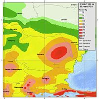
The seismicity of Romania is clustered in several epicentral zones: Vrancea, Făgăraș-Câmpulung, Banat, Crișana, Maramureș, and Southern Dobrogea.[1][2] Other epicentral zones of local importance can be found in Transylvania, in the area of Jibou and Târnava River, in the northern and western part of Oltenia, in northern Moldova, and the Wallachian Plain.[3] The Vrancea seismogenic zone is the most important among these seismic zones, having in mind the energy, the extent of the macroseismic effects, and the persistent and confined character of the earthquakes that occur in this area. The Vrancea area is responsible for over 90% of all earthquakes in Romania, releasing over 95% of the seismic energy.[4] Two belts of moderate and shallower seismicity are emphasized in the other regions of the country: one along the Southern Carpathians and the eastern edge of the Pannonian Basin, the other along the Eastern Carpathians that extends towards SE on the Peceneaga–Camena line.[5][6][7]
During the last 1,000 years, according to historical data, it is thought that 17 earthquakes of 7 and over magnitude have occurred, which suggests a means for unleashing the energy every 58 years. Statistically, the magnitude 6 and over earthquakes in the Vrancea area occur approximately every 10 years, with magnitude 7 every 33 years, while those with 7.5 magnitudes every 80 years.[8]
Earthquakes
Earthquakes listed in the following tables include only M6.0+ events or earthquakes with significant material damage or casualties. All seismic events are shown in detail in the ROMPLUS catalog of the National Institute for Earth Physics. It collected information from the catalog of Constantinescu and Mîrza (1980) for the period 984–1997. After 1997, the catalog was permanently filled and updated with data on seismic events produced in Romania and around national borders.
Parts of the Royal Palace, walls of the Citadel of Angevins and many other buildings in Temesvár collapse.[12] The St. Ladislau Cathedral in Várad is destroyed.[13]
Light damage reported in Meggyes. The pillars of Evangelical Church in Sebeș collapse.[15]Album Oltardianum indicates 20 houses collapsed in Sibiu, while the Chronicle of Hutter reports many deaths among old population.[16]
26 October 1550
6.5
VII–X
Large earthquake in southern Transylvania.
10 August 1590
6.5
VII–X
Large earthquake in southeastern Transylvania, with disastrous effects in Brașov, Râșnov, Sibiu and Mediaș.
5 May 1603
The strongest earthquake ever recorded inside the Carpathian arch. Also felt in Košice, Slovakia.[11]
Four mosques collapse in Nicopolis, the fortress of Niš, on the Serbian side of the Danube, reports significant damage. 11 monasteries, 15 houses, 15 towers and a church steeple collapse in Iași, while the walls and tower of the Prince's Court in Bucharest are destroyed.[17][18]
Chronicles and records of the Orthodox Church indicate extensive damage to churches and tall buildings in Bucharest. This is the strongest earthquake ever recorded in Romania, known by contemporary documents as "great earthquake of Good Friday". Felt on an area of 2 million km². Despite its intensity, only four people were killed.
The earthquake occurs on Thursday morning, at 4 o'clock, causing great panic among population. In Bucharest, 150 stone houses are destroyed or severely damaged.[20] Felt over a very large area from Tisza to Bug and from Mureș to the Danube.[21]
73 deaths were recorded across the country, of which eight only in Bucharest.[23] In Wallachia, 217 churches collapsed or were severely damaged. A massive landslide barred the Bicaz River, forming the Red Lake.[24]
The earthquake had three explosive moments at an interval of three minutes. The last phase generated "frightening jolts" and "formidable underground rumble". It damaged old houses in Bucharest, eastern Wallachia and southern Moldavia.[27]
This was the strongest earthquake recorded in the 20th century in Romania. Its effects were devastating in central and southern Moldavia, but also in Wallachia. The death toll was estimated at 1,000, with an additional figure of 4,000 wounded, mostly in Moldavia.[29] The earthquake was felt in Bucharest, where there were about 300 deaths, mostly from the collapse of Carlton Bloc.[30]
Officially, two dead and 558 injured.[34] In Chișinău, four apartment buildings collapsed, resulting in at least 100 casualties. In Bucharest, 50 workers were killed in the basement of a building, crushed by piles of rubble. The information was never confirmed. Over 50,000 houses were damaged.[35]
14 dead and 362 injured.[36] Severe damage reported on large areas in Romania, Moldova and Bulgaria. Munich Re indicates economic losses of US$30 million.[37]
5,000 rural buildings and a monumental church of German architecture are damaged.[38] 2 dead, 30 injured, hundreds to thousands displaced due to severe damage to buildings.[39]
Cracks in walls and roads were reported in Galați and Tulcea.[42] Telephone network and power supply were disrupted in epicentral area. One man was injured in Tulcea. Eight people were injured in Galați[43] and five hypertensive people in Brăila needed medical care because of panic attacks.[44]
In Iași, a young man jumped out a window, suffering a fracture, and an old woman hurt herself in her house, while 12 people suffered panic attacks.[45]
In Bucharest, an old house was slightly damaged.[46] The Bucharest–Ilfov Ambulance Service registered 25 calls for panic attacks. Power supply was briefly disrupted in Întorsura Buzăului, close to the epicenter.[47]
22 localities affected in five counties – Gorj, Dolj, Hunedoara, Mehedinți and Vâlcea. Four people in Gorj injured by detached construction elements. 48 buildings slightly damaged in Târgu Jiu, close to the epicenter.[51]
The inclusion criteria for adding events are based on WikiProject Earthquakes' notability guideline that was developed for stand alone articles. The principles described are also applicable to lists. In summary, only damaging, injurious, or deadly events should be recorded.
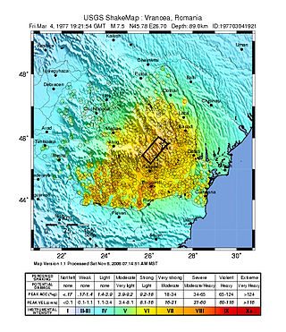
The 1977 Vrancea earthquake occurred on 4 March 1977, at 21:22 local time, and was felt throughout the Balkans. It had a magnitude of 7.5, making it the second most powerful earthquake recorded in Romania in the 20th century, after the 10 November 1940 seismic event. The hypocenter was situated in the Vrancea Mountains, the most seismically active part of Romania, at a depth of 85.3 km.
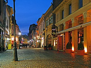
Lipscani is a street and a district of Bucharest, Romania, which from the Middle Ages to the early 19th century was the most important commercial area of the city and Wallachia. It is located near the ruins of the old Princely Court built by Vlad III the Impaler.
Libertatea is a Romanian daily newspaper and online news website covering current affairs, entertainment, sports and lifestyle. It was founded on December 22, 1989 (12:45 p.m.), by Octavian Andronic, as "the first independent newspaper of the Romanian Revolution of 1989".
Immigration to Romania is less common than immigration to most other European Union countries, with Romania having 3.6% of the population foreign born as of 2021. Among immigrants, the most common countries of birth were Republic of Moldova (40%), Italy (11%) and Spain (9%). About two thirds of the foreign born population consists of labour migrants.
Dudu Georgescu is a retired Romanian footballer who played as a forward and a former coach.
Striking central Romania on August 30 at 21:28 UTC, the 1986 Vrancea earthquake killed more than 150 people, injured over 500, and damaged over 50,000 homes. The second largest earthquake in the area since the modernization of earthquake monitoring devices, it was felt north to Poland and south to Italy and Greece. The death toll makes it the second deadliest earthquake to occur in 1986 worldwide, after major seism of San Salvador that took the lives of almost 1,500 people.
The 1940 Vrancea earthquake, also known as the 1940 Bucharest earthquake, occurred on Sunday, 10 November 1940, in Romania, at 03:39, when the majority of the population was at home.
The 1802 Vrancea earthquake occurred in the Vrancea Mountains of today's Romania on 26 October [O.S. 14 October] 1802, on St. Paraskeva's Day. With an estimated intensity of 7.9 on the moment magnitude scale, it is the strongest earthquake ever recorded in Romania and one of the strongest in European history. It was felt across an area of more than two million square kilometers in Eastern Europe and the Balkans, from Saint Petersburg to the Aegean Sea.
The 1838 Vrancea earthquake struck the western part of Vrancea County on 23 January with a magnitude of 7.5. The seism caused extensive damage in Moldavia and Wallachia, and killed dozens of people. The earthquake occurred just 36 years after another earthquake of magnitude over 7 on Richter scale devastated the southern part of Wallachia.
The 1990 Vrancea earthquakes were three earthquakes on 30 and 31 May 1990 with magnitudes of 7.0 Mw and 6.2 Mw that struck the Romanian county of Vrancea, on two consecutive days. Severe damage in the Bucharest-Brăila-Brașov area was reported and dozens of casualties in Romania and neighbouring Moldova, Ukraine and Bulgaria.
Events from the year 1917 in Romania.
This is a list of 2014 events that occurred in Romania.
The 1738 Vrancea earthquake occurred on 11 June [O.S. 31 May] 1738, during the third rule of Constantin Mavrocordat. The seism aroused great panic and is mentioned in several sources. It occurred in the lower lithospheric block, at a depth of 130 km (81 mi). Its effects were violent on large areas, the hardest hit being Bucharest, where several houses and churches collapsed.
The following lists events in the year 2016 in Romania.
The 2014 Vrancea earthquake struck Vrancea County on 22 November 2014 at 21:14:17 local time, with a moment magnitude of 5.7. The earthquake occurred at a depth of 39 kilometers and lasted for thirty seconds. On the Mercalli scale the quake registered an intensity of VI (Strong).
Dumitru Enescu. was a Romanian geophysicist and engineer elected honorary member of the Romanian Academy in 2011. He was born in Drajna de Sus, and died in Bucharest, aged 82. Dumitru Enescu has made important scientific contributions to the development of seismology in Romania.
Viorel Cosma was a Romanian musician and teacher who came to wider prominence as an exceptionally prolific musicologist and a pioneering lexicographer. Through his scholarship he also achieved distinction as a teacher, researcher and music critic. Between 1989 and 2012 he produced a ten volume lexicon, running to 2,800 pages, entitled "Muzicieni din România", providing extensive information on approximately 1,500 Romanian composers and musicians, musicologists, music critics, music teachers, folklorists and other contributors to Romanian music and musicianship.
Alexandru Stoian is a Romanian professional footballer who plays for Liga I club Farul Constanța.
References
↑ Lungu, D.; Aldea, A.; Arion, C. (2008). "Romania's Seismicity and Seismic Hazard: From Historical Records to Design Codes". Harmonization of Seismic Hazard in Vrancea Zone. NATO Science for Peace and Security Series C: Environmental Security. Springer. pp.1–16. doi:10.1007/978-1-4020-9242-8_1. ISBN978-1-4020-9242-8.
↑ Sokolov, Vladimir Yu; Wenzel, Friedemann; Mohindra, Rakesh (2009), "Probabilistic seismic hazard assessment for Romania and sensitivity analysis: A case of joint consideration of intermediate-depth (Vrancea) and shallow (crustal) seismicity", Soil Dynamics and Earthquake Engineering, 29 (2): 364–381, Bibcode:2009SDEE...29..364S, doi:10.1016/j.soildyn.2008.04.004
↑ Ardeleanu, L. et al. (2005) "Probabilistic seismic hazard map for Romania as a basis for a new building code". Natural Hazards and Earth System Sciences 5, 679–684
↑ Oncescu, M., Marza, V. I., Rizescu, M., and Popa, M. (1999). The Romanian earthquake catalogue between 984–1997, Vrancea Earthquakes: Tectonics, Hazard and Risk Mitigation (edited by F. Wenzel et al.), 43–47
↑ Atanasiu I., 1961. Earthquakes in Romania. Academia R.P.R., Bucharest, 194pp. (in Romanian)
↑ Radulian, M., Mândrescu, N., Panza, G.F., Popescu, E., Utale, A. (2000), Characterization of Seismogenic Zones of Romania, Pure appl. geophys. 157, 57–77
↑ Florinesco, A. (1958). Catalogue des tremblements de terre ressentis sul le territoire de la R.P.R. (in French). Bucharest: Romanian People's Republic Academy.
↑ Nussbächer, N. (1987). Din cronici și hrisoave. Contribuții la istoria Transilvaniei. Din cronica cutremurelor în Țara Bârsei (secolele XV–XX) (in Romanian). Kriterion. pp.231–233.
↑ Constantinescu, L.; Marza, V. I. (1980). A computer-compiled and computer-oriented cataloque of Romania's earthquakes during a millenium (984–1979). Rev. Roum. Geologie, Geophysique et Geographie. pp.193–234.
↑ E. S., Georgescu; A., Pomonis (15–16 November 2010). Human casualties due to the Vrancea, Romania earthquakes of 1940 and 1977: learning from past to prepare for future events. Mizunami: Mizunami International Symposium on Earthquake Casualties and Health Consequences.
↑ Romaniță, Maria (23 November 2014). "Panică după cutremur". Monitorul de Galați (in Romanian). Archived from the original on 4 February 2015. Retrieved 24 November 2014.
This page is based on this Wikipedia article Text is available under the CC BY-SA 4.0 license; additional terms may apply. Images, videos and audio are available under their respective licenses.