Tisza

Last updated
Tisza
Szeged-tisza3.jpg
The Tisza in Szeged, Hungary
Tisza.png
Map of the Tisza
Native name
Location
Countries
Towns
Physical characteristics
Source 
  location Eastern Carpathians, Ukraine
  elevation2,020 m (6,630 ft)
Mouth Danube
  location
Downstream of Novi Sad, Serbia
  coordinates
45°8′17″N20°16′39″E / 45.13806°N 20.27750°E / 45.13806; 20.27750 [1]
Length966 km (600 mi)
Basin size156,087 km2 (60,266 sq mi) [2] 154,073.1 km2 (59,488.0 sq mi) [3]
Discharge 
  location Novi Slankamen, Serbia (near mouth)
  average(Period: 1971–2000)920.1 m3/s (32,490 cu ft/s) [3]
  minimum160 m3/s (5,700 cu ft/s)
  maximum4,500 m3/s (160,000 cu ft/s)
Discharge 
  location Szeged, Hungary (173.6 km upstream of mouth - Basin size: 138,857.7 km2 (53,613.3 sq mi) [3]
  average(Period: 1971–2000)890.5 m3/s (31,450 cu ft/s) [3] (Period: 2011–2020)784.7 m3/s (27,710 cu ft/s) [4]
Discharge 
  location Szolnok, Hungary (334.6 km upstream of mouth - Basin size: 72,889.4 km2 (28,142.8 sq mi) [3]
  average(Period: 1971–2000)578.9 m3/s (20,440 cu ft/s) [3]
Discharge 
  location Tokaj, Hungary (543.079 km upstream of mouth - Basin size: 49,120.9 km2 (18,965.7 sq mi) [3]
  average(Period: 1971–2000)468.8 m3/s (16,560 cu ft/s) [3]
Discharge 
  location Vásárosnamény, Hungary (684.45 km upstream of mouth - Basin size: 30,978.9 km2 (11,961.0 sq mi) [3]
  average(Period: 1971–2000)340.6 m3/s (12,030 cu ft/s) [3] (Period: 2011–2020)321.18 m3/s (11,342 cu ft/s) [4]
Basin features
Progression DanubeBlack Sea
River system Danube River
Tributaries 
  left Vișeu, Iza, Tur, Someș, Crasna, Körös, Mureș, Bega
  right Tarac, Talabor, Rika, Borzhava, Bodrog, Sajó, Eger, Zagyva

The Tisza, Tysa or Tisa, is one of the major rivers of Central and Eastern Europe. It was once called "the most Hungarian river" because it used to flow entirely within the Kingdom of Hungary. Today, it crosses several national borders.

Contents

The Tisza begins near Rakhiv in Ukraine, at the confluence of the White Tisa  [ uk ] and Black Tisa  [ uk ], which is at coordinates 48°4′29″N24°14′40″E / 48.07472°N 24.24444°E / 48.07472; 24.24444 (the former springs in the Chornohora mountains; the latter in the Gorgany range). From there, the Tisza flows west, roughly following Ukraine's borders with Romania and Hungary, then briefly as the border between Slovakia and Hungary, before entering into Hungary, and finally into Serbia. The Tisza enters Hungary at Tiszabecs, traversing the country from north to south. A few kilometers south of the Hungarian city of Szeged, it enters Serbia. Finally, it joins the Danube near the village of Stari Slankamen in Vojvodina, Serbia.

The Tisza drains an area of about 156,087 km2 (60,266 sq mi) [2] and has a length of 966 km (600 mi) [5] Its mean annual discharge is seasonally 792 m3/s (28,000 cu ft/s) to 1,050 m3/s (37,000 cu ft/s). It contributes about 13% of the Danube's total runoff. [2]

Attila the Hun is said to have been buried under a diverted section of the river Tisza. [6]

Names

The river was known as the Tisia in antiquity; other ancient names for it included Pathissus (Πάθισσος in Ancient Greek and later Tissus (in Latin)), (Pliny, Naturalis historia , 4.25). It may be referred to as the Theiss in older English references, after the German name for the river, Theiß. It is known as the Tibisco in Italian, and in older French references (as for instance in relation to the naval battles on the Danube between the Ottoman Empire and the Habsburg Empire in the 17th and 18th centuries) it is often referred to as the Tibisque.

Another theory is that it is derived from Proto-Balto-Slavic *teišus meaning still, quiet, silent to describe the river.

Modern names for the Tisza in the languages of the countries it flows through include:

Regulation

The length of the Tisza in Hungary used to be 1,419 km (882 mi). It flowed through the Great Hungarian Plain, which is one of the largest flat areas in central Europe. Since plains can cause a river to flow very slowly, the Tisza used to follow a path with many curves and turns, which led to many large floods in the area.

After several small-scale attempts, István Széchenyi organised the "regulation of the Tisza" (Hungarian : a Tisza szabályozása) which started on August 27 1846, and substantially ended in 1880. The new length of the river in Hungary was reduced to 966 km (600 mi) in total, with 589 km (366 mi) of dead channels and 136 km (85 mi) of new riverbed. [7]

Lake Tisza

In the 1970s, the building of the Tisza Dam at Kisköre started with the purpose of helping to control floods as well as storing water for drought seasons. However, the resulting Lake Tisza became one of the most popular tourist destinations in Hungary since it had similar features to Lake Balaton at drastically cheaper prices and was not crowded.

The Tisza is navigable over much of its course. The river opened up for international navigation only recently; before, Hungary distinguished "national rivers" and "international rivers", indicating whether non-Hungarian vessels were allowed or not. After Hungary joined the European Union, this distinction was lifted and vessels were allowed on the Tisza. [8]

Conditions of navigation differ with the circumstances: when the river is in flood, it is often unnavigable, just as it is at times of extreme drought. [9]

Wildlife

The Tisza has a rich and varied wildlife. Over 200 species of birds reside in the bird reserve of Tiszafüred. The flood plains along the river boast large amounts of diverse plant and animal life. In particular, the yearly "flowering" of the Tisza is considered a local natural wonder. The flowering attracts vast numbers of mayflies which is a well known spectacle. [10] [11]

In September 2020, colonies of magnificent bryozoans were discovered in the river. [12]

Pollution

In early 2000, there was a sequence of serious pollution incidents originating from accidental industrial discharges in Romania. The first, in January 2000, occurred when there was a release of sludge containing cyanide from a Romanian mine and killed 2000 tons of fish. The second, from a mine pond at Baia Borsa, northern Romania, resulted in the release of 20,000 m3 (710,000 cu ft) of sludge containing zinc, lead and copper occurred in early March 2000. A week later, the third spill occurred at the same mining site at Baia Borsa, staining the river black, possibly including heavy metals. [13]

This series of incidents were described at the time as the most serious environmental disaster to hit central Europe since the Chernobyl disaster. Usage of river water for any purpose was temporarily banned and the Hungarian government pressed the Romanians and the European Union to close all installations that could lead to further pollution. [13]

Examination of river sediments indicates that pollution incidents from mines have occurred for over a century. [14]

Geography

Drainage basin

The Tisza River is part of the Danube River catchment area. It is the tributary with the largest catchment area (~157,000 km2). It accounts for more than 19% of the Danube river basin. The Tisza water system is shared by five countries: Ukraine (8%), Slovakia (10%), Hungary (29%), Romania (46%) and Serbia (7%).

The Tisza River Basin area and average discharge (period from 1946–2006) by country [15]

Country Area by country Discharge by country
(km2) (%) (m3/s) (km3) (%)
Hungary Flag of Hungary.svg 46,213 29.4 47 1.5 5.7
Romania Flag of Romania.svg 72,620 46.2 468 14.8 56.4
Serbia Flag of Serbia.svg 10,374 6.6 4.0 0.1 0.5
Slovakia Flag of Slovakia.svg 15,247 9.7 90 2.8 10.8
Ukraine Flag of Ukraine.svg 12,732 8.1 221 7.0 26.6
Tisza River Basin157,186100.083026.2100.0

The 1800–2500 m high ridge of the Carpathian Mountains create in a semi circle the northern, eastern and southeastern boundary of the Tisza catchment. The western - southwestern reach of the watershed is comparatively low in some places – on its Hungarian and Serbian parts it is almost flat. The area is divided roughly along the centreline by the Carpathians Mountains, east of which lies the 400–600 m high plateau of the Transylvanian Basin, and the plains to the west. The highest summits of the river basin reach 1948 m in the Low Tatras (Kráľova hoľa), 2061 m in the Chornogora Mountains (Hoverla), 2303 m in the Rodna Mountains (Pietrosul Rodnei) and even higher in the Retezat Mountains of the Southern Carpathians (Peleaga, 2509 m). Areas above elevations higher than 1600 m occupy only 1% of the total; 46% of the territory lies below 200 m. The Tisza River Basin in the Slovak Republic is predominantly hilly area and the highest mountain peak in Kráľova hoľa - in the Low Tatras Mountain Range at 1948 m. The lowland area lies in the south, forming the northern edge of the Hungarian Lowland. The lowest point in the Slovak Republic is the village of Streda nad Bodrogom in the eastern Slovak lowland (96 m) in the Bodrog River Basin. The Hungarian and Vojvodina (Serbia) part of the Tisza River Basin is a flat area bordered by small ranges of hills and mountains from the north and dominated by the Hungarian lowland. [15]

Important hydrographic stations along the Tisza River (full list) [16] [17] [3]

Station River

kilometer

(rkm)

Altitude

(m)

Basin size

(km2)

Average discharge

(m3/s)*

LeftRight
Lower Tisza
Near mouth070154,073.1920.11
Titel 8.770153,965920.28
Novi Bečej 6670144,007.8893.72
Bečej 7371143,994.6892.81
Bačko Petrovo Selo 8772143,585891,29
Mol 10372142,373.4889.98
Ada 10472142,373.4889.98
Senta 123.573140,849.9886.98
Adorjan 13773140,746886.73
Novi Kneževac 144.573139,717.5885.36
Kanjiža 148.373139,376.8886.5
Srpski Krstur 156.873138,857.7888.69
Szeged 17274138,857.7890.45
Middle Tisza
Maros 17675108,436.1703.43
Algyő 19276107,941703.85
Mindszent 217.777105,881.5703.33
Körös 24478102,643.7698.78
Csongrád 246.27875,520.5583.04
Tiszaug 267.57975,517583.58
Tiszakécske 2747975,056.1583.42
Martfű 306.98074,462.2582.64
Vezseny 3148073,895.9581.43
Tiszavárkony 3228073,895.9581.33
Szolnok 334.68172,889.4578.92
Zagyva 3368167,325562.04
Szajol 3448166,713.4560.39
Nagykörű 363.78266,581.2559.85
Tiszabő 3668266,464.6559.58
Kőtelek 373.88266,315.7559.42
Tiszaroff 379.38366,315.7559.42
Tiszasüly3848366,315.7559.42
Tiszabura 395.68365,840.4558.14
Kisköre 403.58365,624.9557.58
Tiszafüred 430.58863,967.2553.34
Tiszabábolna 4428863,346551.54
Tiszadorogma 446.28863,346551.14
Tiszacsege 453.98963,164.8550.87
Ároktő 454.98963,164.8550.87
Tiszakeszi 464.38963,164.8550.66
Tiszapalkonya 484.79062,557.7549.31
Tiszaújváros 4869062,557.7549.11
Polgár 487.39062,557.7549.11
Sajó 4929049,688.1470.49
Tiszadob 500.29149,600.6470.25
Tiszadada 508.49149,600.6470.06
Tiszalök 518.29349,443469.85
Tokaj 543.19449,167.1468.86
Bodrog 5449434,856.5353.75
Timár 549.49534,810.3353.66
Szabolcs 5559534,810.3352.7
Balsa 557.79634,810.3353.31
Tiszabercel 5699734,713.3352.7
Cigánd 5929832,964.1346.06
Dombrád 593.19832,964.1346.06
Tiszakanyár 597.39832,964.1346.06
Záhony 627.810031,304.7340.39
Chop 63010031,304.7340.39
Vásárosnamény 68210330,978.9340.62
Upper Tisza
Szamos 68610411,870.1202.13
Jánd 69010511,870.1201.96
Kisar Tivadar 70410711,689.7201.51
Tiszabecs 744.31149,950185.86
Vylok 7461159,588.3180.91
Vynohradiv 7671379,366180.91
Khust 7831577,877.8153.54
Bushtyno 8021886,802130.66
Tiachiv 8142106,657.9126.81
Teresva 8202255,205.7101.04
Siçhetu Marmației 8372653,45175.73
Dilove 8853461,294.426.65
Rakhiv 8974371,256.322.13

*Period: 1971–2000

Discharge

Average, minimum and maximum discharge of the Tisza River at Tiszabecs (Upper Tisza), Szolnok (Middle Tisza) and Senta (Lower Tisza). [18] [16] [17] [19] [20]

Year Discharge (m3/s)
Senta Szolnok Tiszabecs
MinMeanMaxMinMeanMaxMinMeanMax
19911183681,550
19921326892,41558.74241,460
1993905371,86061.63631,510
1994906621,74366.94621,500
19952518001,7681015571,450286
19961887692,174440173
19973068841,952509204
19983601,1252,308625288
19993261,1702,8201367042,36060.42551,510
20002429293,400935632,60026.71872,050
20012729492,1501846491,99041.82623,190
20022848171,76098.35171,44044.52371,390
20031605801,420317109.2
20042138672,570525232.7
20053731,1002,580639190.5
20063121,2303,7201367402,44047.32321,980
20071937571,820469215
20082658252,070527258
20091806491,740400172
20105411,4202,8301,083272
20111517362,49079.54541,710142
20121204431,31086207820135
20131357422,450523176
201422249791891.229876045.7111.7415
20151375321,35063.53171,13027.51411,610
20162107081,880874391,50032.6160.81,160
20171876241,630416190.8
20182006982,0601214141,096156.7
20191685811,86090.6370853165.1
20202005821,890120405744174
20212007771,890512187.8
20221255971,61065.6403.51,263192
2023
2024

Tributaries

The rivers of Tisza and Bodrog at Tokaj, from above River Tisza & Bodrog Tokaj.jpg
The rivers of Tisza and Bodrog at Tokaj, from above
The Tisza joins the Danube. 038 Titel, Knicanin, Tisa, Danube - Serbia.jpg
The Tisza joins the Danube.

The following rivers are tributaries to the river Tisza:

The main tributaries of the Tisza River: [21] [22]

Left Right Length (km) Basin size (km2) Average discharge (m3/s)
Lower Tisza
Bega 254.86,249.619.01
Jegrička 65.46161.62
Čik (Csík)629.71.39
Budzak146.20.31
Zlatica (Aranca)1171,430.22.03
Kiriš (Keres-patak)862.31.84
Köröséri főcsatorna77.3804.80.29
Gyálaréti Holt-Tisza18.6481.80.93
Szegedi csatorna17.8790.12
Maros 754.130,331.8190.3
Middle Tisza
Kósdi-csatorna37416.4
Algyői főcsatorna42.61,370.82.79
Percsorai főcsatorna16.292.10.1
Kurca36.91,266.32.7
Dong-ér84.41,672.22.97
Vidre-ér22246.70.28
Körös 363.427,537.4115.86
Alpár–Nyárlőrinci csatorna41271.30.2
Peitsik-ér9.51990.15
Körös-ér56.4564.51.07
Gerje–Perje főcsatorna60.5903.92.17
Zagyva 179.45,676.616.85
Görbe-ér358.51.11
Millér-ér60.4505.91.84
Dobai főcsatorna18.2139.70.21
Saj-foki főcsatorna1.1
Hanyi-ér22331.50.97
Laskó69.2367.51.11
Tiszafüredi főcsatorna0.12
Eger (Rima)87.41,378.63.24
Tiszavalki főcsatorna20.42990.53
Sulymos főcsatorna17.3105.40.39
Rigós39.3148.30.48
Hejő44293.30.66
Sajó 229.412,708.378.62
Bodrog 266.913,578.9119.62
Upper Tisza
Lónyai főcsatorna91.41,957.84.4
Tiszakarádi főcsatorna38.9324.80.5
Belfő csatorna536361.58
Szipa csatorna37.6225.20.49
Kraszna 193.43,142.38.22
Szamos 415.115,881.4135.37
Túr főcsatorna65.2614.9
Túr 94.61,261.814.03
Borzhava (Borsa)103.51,417.918.78
Batar (Batár-patak)53.8395.63.87
Rika (Nagyág)92.81,161.420.19
Khustets (Husztica)1.52
Bailova134.82.04
Tereblia (Talabor)91769.513.47
Martos1323.60.27
Tyachivets (Técső-patak)2986.51.46
Teresva (Tarac)84.81,22422.74
Săpănța127.41.54
Apsica (Apsa-patak)392574.17
Isa (Iza)77.61,293.518.74
Shopurka (Gyertyános)41.42865.31
Kosivska (Kaszó)41157.32.96
Vișeu (Visó)77.51,581.839.08
Bilij (Fejér-patak)1245.50.87
Silskij0.72
Moskva1.50.22
White Tisza33.6484.710.17
Black Tisza50.3566.211.48

Cities and towns

The Tisza (Tisa) flows through the following countries and cities (ordered from the source to mouth):

See also

Related Research Articles

<span class="mw-page-title-main">Geography of Hungary</span>

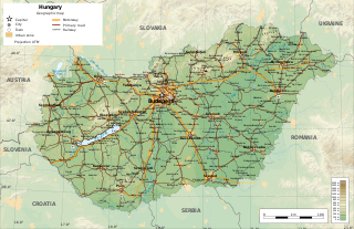
Hungary is a landlocked country in the southeastern region of Central Europe, bordering the Balkans. Situated in the Pannonian Basin, it has a land area of 93,030 square km, measuring about 250 km from north to south and 524 km from east to west. It has 2,106 km of boundaries, shared with Slovakia to the north, Ukraine to the northeast, Romania to the east and southeast, Serbia to the south, Croatia to the southwest, Slovenia to the west and southwest, and Austria to the west.

<span class="mw-page-title-main">Banat</span> Historical region in eastern-central Europe

Banat is a geographical and historical region located in the Pannonian Basin that straddles Central and Eastern Europe. It is currently divided among three countries: the eastern part lies in western Romania ; the western part of Banat is in northeastern Serbia ; and a small northern part lies within southeastern Hungary.

<span class="mw-page-title-main">Mureș (river)</span> River in Eastern Europe

The Mureș or Maros is a 789-kilometre-long (490 mi) river in Eastern Europe. Its drainage basin covers an area of 30,332 km2 (11,711 sq mi). It originates in the Hășmașu Mare Range in the Eastern Carpathian Mountains, Romania, rising close to the headwaters of the river Olt, and joins the Tisza at Szeged in southeastern Hungary. In Romania, its length is 761 km (473 mi) and its basin size is 27,890 km2 (10,770 sq mi).

<span class="mw-page-title-main">Csongrád-Csanád County</span> County of Hungary

Csongrád-Csanád is an administrative county in southern Hungary, straddling the river Tisza, on the border with Serbia and Romania. It shares borders with the Hungarian counties Bács-Kiskun County, Jász-Nagykun-Szolnok County and Békés. The administrative centre of Csongrád-Csanád county is Szeged. The county is also part of the Danube–Criș–Mureș–Tisa Euroregion.

<span class="mw-page-title-main">Körös</span> River Romania

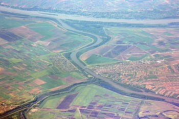
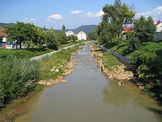
The Körös or Criș is a river in eastern Hungary and western Romania. Its length is 128.6 km (79.9 mi) from the confluence of its two source rivers Fehér-Körös and Fekete-Körös to its outflow into the Tisza. Its drainage basin area is 27,537 km2 (10,632 sq mi). It has three source rivers, all with their origin in the Apuseni Mountains in Transylvania, Romania: Crișul Alb (Fehér-Körös), Crișul Negru (Fekete-Körös) and Crișul Repede (Sebes-Körös). The confluence of the rivers Fehér-Körös and Fekete-Körös is near the town Gyula. The Körös downstream from Gyula is also called the Kettős-Körös. 37.3 km further downstream, near Gyomaendrőd, the Sebes-Körös joins the Körös/Criș. The section downstream from Gyomaendrőd is also called the Hármas-Körös. The Körös flows into the Tisza River near Csongrád.

<span class="mw-page-title-main">Târnava</span> River in Alba County, Romania

The Târnava is a river in Romania. It is formed by the confluence of the Târnava Mare and Târnava Mică in the town of Blaj. The Târnava flows into the Mureș after 23 km near the town of Teiuș. The two source rivers of the Târnava are the Târnava Mare and Târnava Mică, and its tributaries include the Tur, Izvorul Iezerului, Secaș, and the Dunărița. Its drainage basin covers an area of 6,253 km2 (2,414 sq mi).

<span class="mw-page-title-main">Pannonian Basin</span> Large sedimentary basin in Central Europe

The Pannonian Basin, or Carpathian Basin, is a large sedimentary basin situated in southeast Central Europe. After the WW1 and Treaty of Trianon, the geomorphological term Pannonian Plain became more widely used for roughly the same region though with a somewhat different sense, with only the lowlands, the plain that remained when the Pliocene Epoch Pannonian Sea dried out.

<span class="mw-page-title-main">Crișul Alb</span> River in Hungary and Romania

The Crișul Alb (Romanian), is a river in western Romania, in the historical region of Transylvania, and in south-eastern Hungary.

<span class="mw-page-title-main">Great Hungarian Plain</span> Largest part of the Pannonian Plain

The Great Hungarian Plain is a plain occupying the majority of the modern territory of Hungary. It is the largest part of the wider Pannonian Plain. Its territory significantly shrank due to its eastern and southern boundaries being adjusted by the new political borders created after World War I when the Treaty of Trianon was signed in 1920.

<span class="mw-page-title-main">Săsar</span> River in Maramureș County, Romania

The Săsar is a right tributary of the river Lăpuș in Maramureș County, Romania. It discharges into the Lăpuș in Bozânta Mare, southwest of Baia Mare. It is a medium-size river which flows through the cities of Baia Sprie and Baia Mare. Its length is 31 km (19 mi) and its basin size is 306 km2 (118 sq mi).

<span class="mw-page-title-main">Someș</span> River in Satu Mare, Romania and Hungary

The Someș or Szamos is a left tributary of the Tisza in Hungary and Romania. It has a length of 415 km (258 mi), of which 50 km are in Hungary. The Someș is the fifth largest river by length and volume in Romania. The hydrographic basin forms by the confluence at Mica, a commune about 4 km upstream of Dej, of Someșul Mare and Someșul Mic rivers. Someșul Mic originates in the Apuseni Mountains, and Someșul Mare springs from the Rodna Mountains.

<span class="mw-page-title-main">Jász–Nagykun–Szolnok County</span> County of Hungary

Jász–Nagykun–Szolnok is an administrative county in Hungary. It lies in central Hungary and shares borders with the Hungarian counties Pest, Heves, Borsod–Abaúj–Zemplén, Hajdú–Bihar, Békés, Csongrád, and Bács–Kiskun. The rivers Tisza and Körös flow through the county. The capital of Jász–Nagykun–Szolnok county is Szolnok. Its area is 5582 km2. The county is named after the Ossetians (Jasz) and Cumans (Kun) who settled there, along with Szolnok. The county was part of the Danube–Criș–Mureș–Tisa Euroregion between 1997 and 2004.

<span class="mw-page-title-main">Pomorišje</span> Historical region

Pomorišje is a historical geographical region on the banks of the river Mureș that in the past has had a sizable ethnic Serb population. The region is mostly divided between Romania and Hungary, with small part of it in northern Serbia. Today, a Serb minority is present in parts of the region that are part of Romania and Hungary.

<span class="mw-page-title-main">Bega (Tisza)</span> River in Romania, Serbia

The Bega or Begej, is a 244 km long river in Romania and Serbia. It rises in the Poiana Ruscă Mountains in Romania, part of the Carpathian Mountains, and it flows into the Tisa river near Titel, Vojvodina, Serbia. Its drainage basin covers an area of 4,458 km2 (1,721 sq mi), of which 2,362 km2 (912 sq mi) in Romania.

<span class="mw-page-title-main">Hydrology of Hungary</span>

The hydrology of Hungary, is mostly determined by Hungary's lying in the middle of the Carpathian Basin, half surrounded by the Carpathian Mountains. All parts of the country have some outflow. All surface water gravitates towards its southern center, and from there, is united in the Danube, which flows into the Black Sea. The whole of Hungary lies within the Danube drainage basin.

<span class="mw-page-title-main">2000 Baia Mare cyanide spill</span> Leak of cyanide near Baia Mare, Romania, into the Someș River

The 2000 Baia Mare Cyanide spill was a leak of cyanide near Baia Mare, Romania, into the Someș River by the gold mining company Aurul, a joint-venture of the Australian company Esmeralda Exploration and the Romanian government.

<span class="mw-page-title-main">Danube–Criș–Mureș–Tisa Euroregion</span>

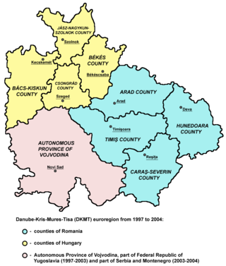
The Danube–Criș–Mureș–Tisa Euroregion is a euroregion located in Hungary, Romania and Serbia. It is named after four rivers: Danube, Criș, Mureș and Tisa.

Danube–Tisza Interfluve is the landscape in Hungarian territory in the Pannonian Basin between the Danube and Tisza rivers, east of Transdanubia. It covers a large part of the Great Hungarian Plain.

References

  1. Tisza at GEOnet Names Server
  2. 1 2 3 Tockner, Klement; Uehlinger, Urs; Robinson, Christopher T., eds. (2009). Rivers of Europe (First ed.). London: Academic Press. Sec. 3.9.5. ISBN   978-0-12-369449-2.
  3. 1 2 3 4 5 6 7 8 9 10 11 "Danube River".
  4. 1 2 Vízgyűjtő-gazdálkodási Terv-2021 (PDF). 2022.
  5. "Analysis of the Tisza River Basin 2007- Initial step toward the Tisza River Basin Management Plan – 2009" (PDF). www.icpdr.or. March 2008. Retrieved 5 February 2021.
  6. Ildiko Ecsedy, "The Oriental Background to the Hungarian Tradition about 'Attila's Tomb'", Acta Orientalia , 36 (1982), pp. 129-153
  7. "Danube + Tisza River". danube.panda.org. Retrieved 5 November 2019.
  8. "Declaration On Co-Operation Concerning The Tisza/Tisa River Basin And Initiative On The Sustainable Spatial Development Of The Tisza/Tisa River | International Environmental Agreements (IEA) Database Project". iea.uoregon.edu. Retrieved 2019-02-03.
  9. NoorderSoft Waterway Database; accessed 13 March 2016.
  10. Konyvek, Szalay (2009). Our Beloved Hungaricums. Pannon-Literatura Kft. p. 94. ISBN   978-963-251-145 0.
  11. Klaushik. "Blooming of the Tisza". amusingplanet.com. Retrieved 25 November 2019.
  12. Đorđe Đukić (8 September 2020). "Otkriveni organizmi stari 500 miliona godina" [Organisms originating rom 500 million years ago discovered]. Politika (in Serbian). p. 12.
  13. 1 2 "Third pollution spill hits Hungary". BBC. 15 March 2000. Retrieved 11 October 2010.
  14. H. L. Nguyen; M. Braun; I. Szaloki; W. Baeyens; R. Van Grieken; M. Leermakers (2009). "Tracing the Metal Pollution History of the Tisza River". Water, Air, and Soil Pollution. 200: 119–132. doi:10.1007/s11270-008-9898-2. S2CID   94627373.
  15. 1 2 "Tisza River Basin 2007".
  16. 1 2 "Republički hidrometeorološki zavod".
  17. 1 2 "Vízügyi honlap".
  18. "ICPDR".
  19. "Vízgazdálkodási Évkönyvek-Közép-Tisza-vidéki Vízügyi Igazgatóság".
  20. "KSH".
  21. "Danube".
  22. "Magyarország vízgyűjtő-gazdálkodási honlapja".