The highways in Victoria are the highest density in any state in Australia. Unlike Australia's other mainland states where vast areas are very sparsely inhabited "outback", population centres spread out over most of the state, with only the far north-west and the Victorian Alps lacking permanent settlement. Highways have therefore been built to service the population centres.
The highways generally radiate from Melbourne and other major cities and rural centres with secondary roads interconnecting the highways to each other.
Many of the highways are built to freeway standard ("M" freeways), while most others are generally sealed and of reasonable quality.
Numbering
Victorian cities, towns, settlements and road network.
Victorian highway naming is straightforward. Most are generally named after the geographical regions and features, cities, towns and settlements along the way. Some are even more straightforward e.g. Western and Northern highways which radiate westwards and northwards from Melbourne. Notable exceptions include some interstate highways and some metropolitan highways.
The numbering system is based on "ring and spoke" system. The 'ring' highways (highways that circle Victoria) numbers are given in the multiple of hundreds e.g. Henty Highway (200), Murray Valley Highway (400) and Great Alpine Road (500) make the outermost ring. Midland Highway (300) and Maroondah Highway (300) is the inner ring.
The spokes generally inherit their original National Route numbers. Otherwise, east-west aligned highways are given even numbers and north-south are given odd numbers. Highways and primary roads are given numbers in multiple of tens. Other roads are given numbers which indicate their general alignment.
Hume Highway, inclusive of the sections now known as Hume Freeway and Hume Motorway, is one of Australia's major inter-city national highways, running for 840 kilometres (520 mi) between Melbourne in the southwest and Sydney in the northeast. Upgrading of the route from Sydney's outskirts to Melbourne's outskirts to dual carriageway was completed on 7 August 2013.
An exit number is a number assigned to a road junction, usually an exit from a freeway. It is usually marked on the same sign as the destinations of the exit. In some countries, such as the United States, it is also marked on a sign in the gore.
Highways in Australia are generally high capacity roads managed by state and territory government agencies, though Australia's federal government contributes funding for important links between capital cities and major regional centres. Prior to European settlement, the earliest needs for trade and travel were met by narrow bush tracks, used by tribes of Indigenous Australians. The formal construction of roads began in 1788, after the founding of the colony of New South Wales, and a network of three major roads across the colony emerged by the 1820s. Similar road networks were established in the other colonies of Australia. Road construction programs in the early 19th century were generally underfunded, as they were dependent on government budgets, loans, and tolls; while there was a huge increase in road usage, due to the Australian gold rushes. Local government authorities, often known as Road Boards, were therefore established to be primarily responsible for funding and undertaking road construction and maintenance. The early 1900s saw both the increasingly widespread use of motorised transportation, and the creation of state road authorities in each state, between 1913 and 1926. These authorities managed each state's road network, with the main arterial roads controlled and maintained by the state, and other roads remaining the responsibility of local governments. The federal government became involved in road funding in the 1920s, distributing funding to the states. The depression of the 1930s slowed the funding and development of the major road network until the onset on World War II. Supply roads leading to the north of the country were considered vital, resulting in the construction of Barkly, Stuart, and Eyre Highways.
Princes Highway is a major road in Australia, extending from Sydney via Melbourne to Adelaide through the states of New South Wales, Victoria and South Australia. It has a length of 1,941 kilometres (1,206 mi) or 1,898 kilometres (1,179 mi) via the former alignments of the highway, although these routes are slower and connections to the bypassed sections of the original route are poor in many cases.
EastLink is a tolled section of the M3 freeway linking a large area through the eastern and south-eastern suburbs of Melbourne, Australia.
Victoria has the highest density of roads of any state in Australia. Unlike Australia's other mainland states where vast areas are very sparsely inhabited, Victoria has population centres spread out over most of the state, with only the far north-west and the Victorian Alps without permanent settlement. Population centres are linked by high quality highways and freeways. The state capital, Melbourne, has the most extensive freeway network of any city in Australia.
The Monash Freeway is a major urban freeway in Victoria, Australia, linking Melbourne's CBD to its south-eastern suburbs and beyond to the Gippsland region. It carries up to 180,000 vehicles per day and is one of Australia's busiest freeways. The entire stretch of the Monash Freeway bears the designation M1.
Calder Highway is a rural highway in Australia, linking Mildura and the Victoria/New South Wales border to Bendigo, in North Central Victoria. South of Bendigo, where the former highway has been upgraded to freeway-standard, Calder Freeway links to Melbourne, subsuming former alignments of Calder Highway; the Victorian Government completed the conversion to freeway standard from Melbourne to Bendigo on 20 April 2009.
Princes Freeway is a 159-kilometre (99 mi) Australian freeway, divided into two sections, both located in Victoria, Australia. The freeway links Melbourne to Geelong in the west, and to Morwell in the east. It continues beyond these extremities as the Princes Highway towards Adelaide to the west and Sydney to the northeast. The freeway bears the designation M1.
The Mornington Peninsula Freeway is a freeway in Melbourne, Victoria, Australia, that provides a link from south-eastern suburban Melbourne to the Mornington Peninsula. Whilst the entire freeway from Dingley Village to Rosebud is declared by VicRoads as the Mornington Peninsula Freeway, the section between EastLink in Carrum Downs and Moorooduc Highway in Moorooduc is locally and commonly known as Peninsula Link. The entire freeway corridor bears the designation M11.
A routenumber, designation or abbreviation is an identifying numeric designation assigned by a highway authority to a particular stretch of roadway to distinguish it from other routes and, in many cases, also to indicate its classification, general geographical location and/or orientation. The numbers chosen may be used solely for internal administrative purposes; however, in most cases they are also displayed on roadside signage and indicated on maps.
The Western Highway is the Victorian part of the principal route linking the Australian cities of Melbourne and Adelaide, with a length of approximately 258 kilometres (160 mi) of single carriageway, then 161 kilometres (100 mi) of dual carriageway known as the Western Freeway. It is a part of the National Highway network and designated routes A8 and M8. The western end continues into South Australia as the Dukes Highway, the next section of the Melbourne–Adelaide National Highway. The Western Freeway joins Melbourne's freeway network via the Western Ring Road, in the western suburbs of Melbourne.
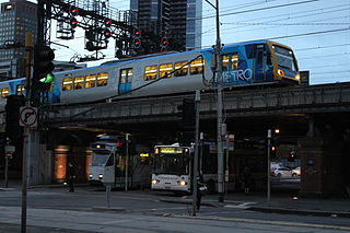
Transport in Melbourne, the state capital of Victoria, Australia, consists of several interlinking modes. Melbourne is a hub for intercity, intracity and regional travel. Road-based transport accounts for most trips across many parts of the city, facilitated by Australia's largest freeway network. Public transport, including the world's largest tram network, trains and buses, also forms a key part of the transport system. Other dominant modes include walking, cycling and commercial-passenger vehicle services such as taxis.
Greensborough Highway is a highway in the north-eastern suburbs of Melbourne, Australia, and is an important route for north-east Melbourne. This name is not widely known to most drivers, as the entire allocation is still best known as by the names of its constituent parts: Lower Heidelberg Road, Rosanna Road, Lower Plenty Road, Greensborough Road and Greensborough Bypass. This article will deal with the entire length of the corridor for sake of completion, as well to avoid confusion between declarations.
The North East Link is an under construction 26–kilometre tolled motorway scheme in Melbourne, Australia. Its stated objective is to connect the Metropolitan Ring Road at Greensborough with the Eastern Freeway at Bulleen, where the freeway would be upgraded from Hoddle Street to Springvale Road at Nunawading.
The M80 Ring Road is a currently incomplete urban freeway ring road around Melbourne, Australia. This article will deal with the entire length of the corridor for sake of completion, as well to avoid confusion between declarations.
This page is based on this Wikipedia article Text is available under the CC BY-SA 4.0 license; additional terms may apply. Images, videos and audio are available under their respective licenses.