List of hospitals in Cameroon

Last updated

Map all coordinates using: OpenStreetMap
Provinces of Cameroon Provinces of Cameroon EN.svg
Provinces of Cameroon

The following is a list of hospitals in Cameroon by region showing the type and location of the hospitals. [1] [2]

Contents

Large hospitals in Cameroon, such as the 650 bed-Central Hospital of Yaoundé founded in 1933, date from the French and British rule period. The General Hospital in Yaoundé was originally established for blacks only. [3]

Beginning in 2016, Cameroon's health infrastructure was organized into the 10 Regions containing 189 health districts, 1800 health areas managed by the Cameroonian Ministry of Public Health. There are district hospitals in most districts and regional hospitals in all Regions except the East Region. There were approximately 5166 public and private health facilities spread throughout the national territory. Access to health services in Cameroon in 2016 was at 2.19 health facilities per 10,000 inhabitants. Besides public hospitals, there are also non-profit hospitals managed for the most part by religious organizations. There are several hospitals in Cameroon built by or supported by the Chinese Ministry of Health. [4] The health facilities are organized into seven main categories: general hospitals, central hospitals, regional hospitals, district hospitals, district medical centers, Integrated health centers and ambulatory health centers. [5]

Adamawa

The Ministry of Public Health has established nine health districts in the Adamawa Region. There are five district hospitals, one private hospital, and one regional hospital in the Adamawa Region. [6]

Hospitals in the Adamawa Region
NameTypeCity/Commune, Coords., Refs. [7]
Bankim Hôpital de DistrictDistrict, Ministry of Public Health Bankim, 6°04′42″N11°29′30″E / 6.0784°N 11.4917°E / 6.0784; 11.4917 (Bankim District Hospital) [2]
Banyo Hôpital de DistrictDistrict, Ministry of Public Health Banyo, 6°44′43″N11°47′16″E / 6.7454°N 11.7878°E / 6.7454; 11.7878 (Banyo District Hospital) [2]
Baptist Hospital BanyoNon-profit, Cameroon Baptist Convention Healthcare Banyo, 6°45′07″N11°49′51″E / 6.751869113693811°N 11.830960369380644°E / 6.751869113693811; 11.830960369380644 (Baptist Hospital Banyo) [8]
Boumdjere Regional HôpitalRegional, Ministry of Public Health Boumdjere [2]
Belel Centre Médical d'ArrondissementCentre, Ministry of Public Health Belel, 7°02′45″N14°26′08″E / 7.0458°N 14.4356°E / 7.0458; 14.4356 (Belel Medical Centre) [2]
Dang Centre Médical d'ArrondissementCentre, Ministry of Public Health Dang, 7°25′12″N13°33′14″E / 7.4201°N 13.5538°E / 7.4201; 13.5538 (Dang Medical Centre) [2]
Dibi Centre Médical d'ArrondissementCentre, Ministry of Public Health Dibi, 7°08′32″N13°43′00″E / 7.1421°N 13.7168°E / 7.1421; 13.7168 (Dibi Medical Centre) [2]
Dir Centre Médical d'ArrondissementCentre, Ministry of Public Health Dir, 6°19′09″N13°32′39″E / 6.3193°N 13.5443°E / 6.3193; 13.5443 (Dir Medical Centre) [2]
Djohong Hôpital de DistrictDistrict, Ministry of Public Health Djohong, 6°49′53″N14°41′40″E / 6.8313°N 14.6945°E / 6.8313; 14.6945 (Djohong District Hospital) [2]
Galim-Tignère Centre Médical d'ArrondissementCentre, Ministry of Public Health Galim-Tignère, 7°05′54″N12°27′53″E / 7.0982°N 12.4647°E / 7.0982; 12.4647 (Galim-Tignère Medical Centre) [2]
Kontcha Centre Médical d'ArrondissementCentre, Ministry of Public Health Kontcha, 7°58′23″N12°13′38″E / 7.9731°N 12.2272°E / 7.9731; 12.2272 (Kontcha Medical Centre) [2]
Mayo-Baléo Centre Médical d'ArrondissementCentre, Ministry of Public Health Mayo-Baléo, 7°39′08″N12°19′51″E / 7.6521°N 12.3308°E / 7.6521; 12.3308 (Mayo-Baléo Medical Centre) [2]
Mayo-Darlé Centre Médical d'ArrondissementCentre, Ministry of Public Health Mayo-Darlé, 6°30′01″N11°32′57″E / 6.5002°N 11.5491°E / 6.5002; 11.5491 (Mayo-Darlé Medical Centre) [2]
Mbe Centre Médical d'ArrondissementCentre, Ministry of Public Health Mbe, 7°51′17″N13°35′53″E / 7.8547°N 13.5981°E / 7.8547; 13.5981 (Mbe Medical Centre) [2]
Meiganga Hôpital de DistrictDistrict, Ministry of Public Health Meiganga, 6°30′38″N14°17′49″E / 6.5106°N 14.2970°E / 6.5106; 14.2970 (Meiganga District Hospital) [2]
Ngaoundal Centre Medical d’ArrondissementCentre, Ministry of Public Health Ngaoundal, 6°30′00″N13°16′00″E / 6.5000°N 13.2667°E / 6.5000; 13.2667 (Ngaoundal Medical Centre) [2]
Ngaoundere Hôpital RegionalRegional, Ministry of Public Health Ngaoundéré, 7°18′24″N13°34′56″E / 7.3067°N 13.5823°E / 7.3067; 13.5823 (Ngaoundere Regional Hospital) [2]
Nyambaka Centre Médical d'ArrondissementCentre, Ministry of Public Health Nyambaka, 6°53′54″N14°05′07″E / 6.8983°N 14.0854°E / 6.8983; 14.0854 (Nyambaka Medical Centre) [2]
Protestant Hospital of Ngaoundéré Non-profit, Global Health Ministries Ngaoundéré, 7°18′34″N13°35′49″E / 7.309382°N 13.596818°E / 7.309382; 13.596818 (Protestant Hospital of Ngaoundéré) [2]
Songkolong Centre Médical d'ArrondissementCentre, Ministry of Public Health Songkolong, 6°23′43″N11°19′24″E / 6.3953°N 11.3233°E / 6.3953; 11.3233 (Songkolong Medical Centre) [2]
Tibati Centre Médical d'ArrondissementCentre, Ministry of Public Health Tibati, 6°27′47″N12°37′21″E / 6.4631°N 12.6224°E / 6.4631; 12.6224 (Tibati Medical Centre) [2]
Tignère Hôpital de DistrictDistrict, Ministry of Public Health Tignère, 7°21′14″N12°38′59″E / 7.3538°N 12.6497°E / 7.3538; 12.6497 (Tignère District Hospital) [2]

Centre

The Ministry of Public Health has established 30 health districts in the Centre Region. There are 27 district hospitals, one Central Hospital and University (CHU), and one regional hospital in the Centre Region. The Central Hospital of Yaoundé, founded in 1933, is the largest hospital in Cameroon with 650 beds. [6] [3]

Hospitals in the Centre Region
NameTypeCity/Commune, Coords., Refs. [7]
Akonolinga Hôpital de DistrictDistrict, Ministry of Public Health Akonolinga, 3°46′40″N12°15′21″E / 3.7778°N 12.2559°E / 3.7778; 12.2559 (Akonolnga District Hospital) [2]
Awaé Hôpital de DistrictDistrict, Ministry of Public Health Awaé, 3°54′14″N11°52′52″E / 3.9039°N 11.8810°E / 3.9039; 11.8810 (Awaé District Hospital) [2]
Ayos Annex Hôpital RegionalRegional, Ministry of Public Health Ayos, 3°53′51″N12°31′48″E / 3.8976°N 12.5299°E / 3.8976; 12.5299 (Ayos Annex Regional Hospital) [2]
Bafia Hôpital de DistrictDistrict, Ministry of Public Health Bafia, 4°44′26″N11°14′07″E / 4.7406°N 11.2354°E / 4.7406; 11.2354 (Bafia District Hospital) [2]
Biyem-Assi Hôpital de DistrictDistrict, Ministry of Public Health Yaoundé, 3°49′35″N11°29′15″E / 3.8263°N 11.4874°E / 3.8263; 11.4874 (Biyem-Assi District Hospital) [2]
Cabinet Medicale de La CathedralePrivate, Catholic Church Yaoundé, 3°53′03″N11°32′05″E / 3.8840773062312364°N 11.534819824522462°E / 3.8840773062312364; 11.534819824522462 (Cathederal Medical Center) [9]
Central Hospital of Yaoundé Central, Ministry of Public Health Yaoundé, 3°52′17″N11°30′37″E / 3.8714°N 11.5104°E / 3.8714; 11.5104 (Central Hospital Yaounda) [9] [1]
Centre Hospitalier et Universitaire de Yaoundé CHU, University of Yaoundé Yaoundé, 3°51′46″N11°29′48″E / 3.862676°N 11.496645°E / 3.862676; 11.496645 (CHU Yaoundé) [9]
Cite Verte Hôpital de DistrictDistrict, Ministry of Public Health Yaoundé, 3°52′15″N11°29′33″E / 3.8707°N 11.4926°E / 3.8707; 11.4926 (Cite Verte District Hospital) [2]
D'joungolo Hôpital de DistrictDistrict, Ministry of Public Health Yaoundé, 3°53′06″N11°31′59″E / 3.8851°N 11.5331°E / 3.8851; 11.5331 (D'Joungolo District Hospital) [2]
Ebebda Hôpital de DistrictDistrict, Ministry of Public Health Ebebda, 4°21′00″N11°18′01″E / 4.3499°N 11.3002°E / 4.3499; 11.3002 (Ebebda District Hospital) [2]
Efoulan Hôpital de DistrictDistrict, Ministry of Public Health Efoulan, 3°49′46″N11°30′40″E / 3.8295°N 11.5110°E / 3.8295; 11.5110 (Efoulan District Hospital) [2]
Elig-Mfomo Hôpital de DistrictDistrict, Ministry of Public Health Elig-Mfomo, 4°16′37″N11°07′12″E / 4.2770°N 11.1201°E / 4.2770; 11.1201 (Elig-Mfomo District Hospital) [2]
Eséka Hôpital de DistrictDistrict, Ministry of Public Health Eséka, 3°38′22″N10°46′31″E / 3.6395°N 10.7753°E / 3.6395; 10.7753 (Eséka District Hospital) [2]
Esse Hôpital de DistrictDistrict, Ministry of Public Health Esse, 4°05′33″N11°53′07″E / 4.0924°N 11.8852°E / 4.0924; 11.8852 (Esse District Hospital) [2]
Essos Centre HospitalCentre, Ministry of Public Health Yaoundé, 3°52′26″N11°32′27″E / 3.8740°N 11.5409°E / 3.8740; 11.5409 (Essos Centre Hospital) [2]
Evodoula Hôpital de DistrictDistrict, Ministry of Public Health Evodoula, 4°05′32″N11°12′00″E / 4.0923°N 11.2001°E / 4.0923; 11.2001 (Evodoula District Hospital) [2]
Hôpital Général de Yaoundé General Yaoundé, 3°54′24″N11°32′29″E / 3.9066°N 11.5414°E / 3.9066; 11.5414 (Hospital General, Yaoundé) [9] [1] [2]
Institute Pasteur (Ritha Moussongi)Private, Pasteur Institute Yaoundé, 3°52′25″N11°30′40″E / 3.8736939904663146°N 11.511108826781074°E / 3.8736939904663146; 11.511108826781074 (Institute Pasteur) [9]
Mbalmayo District HospitalDistrict, Ministry of Public Health Mbalmayo, 3°30′52″N11°30′32″E / 3.5145°N 11.5089°E / 3.5145; 11.5089 (Mbalmayo District Hospital) [2]
Mbandjock Hôpital de DistrictDistrict, Ministry of Public Health Mbandjock, 4°26′34″N11°54′28″E / 4.4428°N 11.9079°E / 4.4428; 11.9079 (Mbandjock District Hospital) [2]
Mbankomo Hôpital de DistrictDistrict, Ministry of Public Health Mbankomo, 3°46′48″N11°24′00″E / 3.7800°N 11.4000°E / 3.7800; 11.4000 (Mbankomo District Hospital) [2]
Mfou Hôpital de DistrictDistrict, Ministry of Public Health Mfou, 3°43′02″N11°38′46″E / 3.7172°N 11.6462°E / 3.7172; 11.6462 (Mfou District Hospital) [2]
Monatélé Hôpital de DistrictDistrict, Ministry of Public Health Monatélé, 4°15′01″N11°12′10″E / 4.2502°N 11.2028°E / 4.2502; 11.2028 (Monatélé District Hospital) [2]
Nanga Eboko Hôpital de DistrictDistrict, Ministry of Public Health Nanga Eboko, 4°39′28″N12°22′15″E / 4.6578°N 12.3708°E / 4.6578; 12.3708 (Nanga Eboko District Hospital) [2]
Ndikiniméki Hôpital de DistrictDistrict, Ministry of Public Health Ndikiniméki, 4°45′03″N10°49′39″E / 4.7508°N 10.8276°E / 4.7508; 10.8276 (Ndikiniméki District Hospital) [2]
Ngog-Mapubi Hôpital de DistrictDistrict, Ministry of Public Health Ngog-Mapubi, 3°56′33″N10°50′25″E / 3.9425°N 10.8404°E / 3.9425; 10.8404 (Ngog-Mapubi District Hospital) [2]
Ngoumou Hôpital de DistrictDistrict, Ministry of Public Health Ngoumou, 3°35′30″N11°18′26″E / 3.5917°N 11.3072°E / 3.5917; 11.3072 (Ngoumou District Hospital) [2]
Nkolndongo District HospitalDistrict, Ministry of Public Health Yaoundé, 3°51′19″N11°32′05″E / 3.8554°N 11.5346°E / 3.8554; 11.5346 (Nkolndongo District Hospital) [2]
Ntui Hôpital de DistrictDistrict, Ministry of Public Health Ntui, 4°26′11″N11°37′56″E / 4.4363°N 11.6323°E / 4.4363; 11.6323 (Ntui District Hospital) [2]
Obala Hôpital de DistrictDistrict, Ministry of Public Health Obala, 4°09′22″N11°32′16″E / 4.1562°N 11.5378°E / 4.1562; 11.5378 (Obala District Hospital) [2]
Olembe Hôpital de DistrictDistrict, Ministry of Public HealthOlembe, Yaoundé 3°50′33″N11°33′26″E / 3.8425°N 11.5573°E / 3.8425; 11.5573 (Olembe District Hospital) [2]
Sa'a Hôpital de DistrictDistrict, Ministry of Public Health Sa'a, 4°21′23″N11°26′53″E / 4.3564°N 11.4480°E / 4.3564; 11.4480 (Sa'a District Hospital) [2]
Soa Hôpital de DistrictDistrict, Ministry of Public Health Soa, 3°55′00″N11°35′05″E / 3.9167°N 11.5846°E / 3.9167; 11.5846 (Soa District Hospital) [2]
Yaoundé Gynaecology, Obstetrics and Pediatrics Hospital Specialist, Chinese Ministry of Health Yaoundé 3°52′31″N11°31′48″E / 3.875195°N 11.529926°E / 3.875195; 11.529926 (Yaoundé Gynaecology, Ost.. and Ped Hospital) [1] [10]
Yoko Hôpital de DistrictDistrict, Ministry of Public Health Yoko, 5°32′21″N12°19′13″E / 5.5391°N 12.3203°E / 5.5391; 12.3203 (Yoko District Hospital) [2]

East

The Ministry of Public Health has established 14 health districts in the East Region. There are 14 district hospitals in the East Region. [6]

Hospitals in the East Region
NameTypeCity/Commune, Coords., Refs [7]
Abong-Mbang Hôpital de DistrictDistrict, Ministry of Public Health Abong-Mbang, 3°58′42″N13°10′55″E / 3.9783°N 13.1820°E / 3.9783; 13.1820 (Abong-Mbang District Hospital) [2]
Batouri Hôpital de DistrictDistrict, Ministry of Public Health Batouri, 4°26′29″N14°22′28″E / 4.4413°N 14.3744°E / 4.4413; 14.3744 (Batouri District Hospital) [2]
Bertoua Hôpital de DistrictDistrict, Ministry of Public Health Bertoua, 4°33′16″N13°41′00″E / 4.5545°N 13.6834°E / 4.5545; 13.6834 (Bertoua District Hospital) [2]
Bétaré-Oya Hôpital de DistrictDistrict, Ministry of Public Health Bétaré-Oya, 5°35′18″N14°05′15″E / 5.5883°N 14.0875°E / 5.5883; 14.0875 (Bétaré-Oya District Hospital) [2]
Doume Hôpital de DistrictDistrict, Ministry of Public Health Doumé, 4°14′19″N13°26′27″E / 4.2386°N 13.4408°E / 4.2386; 13.4408 (Doume District Hospital) [2]
Garoua Boulai Hôpital de DistrictDistrict, Ministry of Public Health Garoua, 5°51′55″N14°33′24″E / 5.8653°N 14.5566°E / 5.8653; 14.5566 (Garoua Boulai District Hospital) [2]
Kette Hôpital de DistrictDistrict, Ministry of Public Health Kette, 4°53′00″N14°32′45″E / 4.8833°N 14.5457°E / 4.8833; 14.5457 (Kette District Hospital) [2]
Lomie Hôpital de DistrictDistrict, Ministry of Public Health Lomié, 3°09′33″N13°37′11″E / 3.1593°N 13.6196°E / 3.1593; 13.6196 (Lomie District Hospital) [2]
Mbang Hôpital de DistrictDistrict, Ministry of Public Health Mbang, 3°57′43″N14°16′04″E / 3.9619°N 14.2678°E / 3.9619; 14.2678 (Mbang District Hospital) [2]
Messamena Hôpital de DistrictDistrict, Ministry of Public Health Messamena, 3°43′57″N12°49′27″E / 3.7325°N 12.8241°E / 3.7325; 12.8241 (Messamena District Hospital) [2]
Moloundou Hôpital de DistrictDistrict, Ministry of Public Health Moloundou, 2°02′54″N15°12′55″E / 2.0482°N 15.2152°E / 2.0482; 15.2152 (Moloundou District Hospital) [2]
Ndelele Hôpital de DistrictDistrict, Ministry of Public Health Ndelele, 4°02′12″N14°55′47″E / 4.0368°N 14.9297°E / 4.0368; 14.9297 (Ndelele District Hospital) [2]
Nguelemendouka Hôpital de DistrictDistrict, Ministry of Public Health Nguelemendouka, 4°23′46″N12°55′31″E / 4.3960°N 12.9253°E / 4.3960; 12.9253 (Nguelemendouka District Hospital) [2]
Yokadouma Hôpital de DistrictDistrict, Ministry of Public Health Yokadouma, 3°31′04″N15°02′53″E / 3.5178°N 15.0480°E / 3.5178; 15.0480 (Yokadouma District Hospital) [2]

Littoral

The Ministry of Public Health has established 24 health districts in the Littoral Region. There are 18 district hospitals in the Littoral Region. [6]

Hospitals in the Littoral Region
NameTypeCity/Commune, Coords., Refs. [7]
Bonamoussadi Ad Lucem Hôpital de DistrictDistrict, Ministry of Public Health Douala, 4°05′01″N9°43′31″E / 4.0836°N 9.7253°E / 4.0836; 9.7253 (Bonamoussadi Ad Lucem District Hospital) , [2]
Bonassama Hôpital de DistrictDistrict, Ministry of Public Health Bonabéri, 4°04′23″N9°41′08″E / 4.0731380910526065°N 9.685597934818913°E / 4.0731380910526065; 9.685597934818913 (Bonassama District Hospital) [2]
Chinese HospitalGeneral hospital, Chinese Ministry of Health Douala, 4°03′24″N9°46′01″E / 4.056546842086936°N 9.767043209179782°E / 4.056546842086936; 9.767043209179782 (Chinese Hospital) [9] [10]
Cite Des Palmiers Hôpital de DistrictDistrict, Ministry of Public Health Douala, 4°02′31″N9°45′42″E / 4.0420°N 9.7617°E / 4.0420; 9.7617 (Cite Des Palmiers District Hospital) [2]
Deido Hôpital de DistrictDistrict, Ministry of Public Health Douala, 4°01′44″N9°40′57″E / 4.0289°N 9.6826°E / 4.0289; 9.6826 (Deido District Hospital) [2]
Dibombari Hôpital de DistrictDistrict, Ministry of Public Health Dibombari, 4°10′43″N9°39′22″E / 4.1787°N 9.6561°E / 4.1787; 9.6561 (District Hospital) [2]
Douala Hôpital GeneralGeneral, Ministry of Public Health Douala, 4°03′17″N9°45′30″E / 4.0548°N 9.7582°E / 4.0548; 9.7582 (Douala Hospital General) [2]
Edéa Hôpital RegionalRegional, Ministry of Public Health Edéa, 3°47′26″N10°06′59″E / 3.7905°N 10.1165°E / 3.7905; 10.1165 (Edéa Regional Hospital) [2]
Ekol-Mbeng Hôpital RegionalRegional, Ministry of Public Health Nkongsamba. 4°57′37″N9°55′51″E / 4.9604°N 9.9307°E / 4.9604; 9.9307 (Ekol-Mben Regional Hospital) [2]
Laquintinie HospitalMinistry of Public Health Douala, 4°02′55″N9°42′12″E / 4.048625025497793°N 9.703369882461907°E / 4.048625025497793; 9.703369882461907 (Laquintinie Hospital) [11]
Logbaba Hôpital de DistrictDistrict, Ministry of Public Health Douala, 4°01′32″N9°45′15″E / 4.0255°N 9.7542°E / 4.0255; 9.7542 (Logbaba District Hospital) [2]
Loum Hôpital de DistrictDistrict, Ministry of Public Health Loum, 4°42′56″N9°43′49″E / 4.7156°N 9.7302°E / 4.7156; 9.7302 (Loum District Hospital) [2]
Manjo Hôpital de DistrictDistrict, Ministry of Public Health Manjo, 4°50′19″N9°49′20″E / 4.8386°N 9.8222°E / 4.8386; 9.8222 (Manjo District Hospital) [2]
Manoka Hôpital de DistrictDistrict, Ministry of Public Health Manoka, 4°01′41″N9°40′56″E / 4.0281°N 9.6823°E / 4.0281; 9.6823 (Manoka District Hospital) [Note 1] [2]
Mbanga Hôpital de DistrictDistrict, Ministry of Public Health Mbanga, 4°29′16″N9°33′51″E / 4.4877°N 9.5643°E / 4.4877; 9.5643 (Mbanga District Hospital) [2]
Mboppi Baptist HospitalNon-profit, Cameroon Baptist Convention Healthcare Douala, 4°02′29″N9°42′58″E / 4.0412866445764015°N 9.71614190917974°E / 4.0412866445764015; 9.71614190917974 (Mboppi Baptist Hospital) [12]
Melong Hôpital de DistrictDistrict, Ministry of Public Health Melong, 5°06′44″N9°56′27″E / 5.1121°N 9.9407°E / 5.1121; 9.9407 (Melong District Hospital) [2]
Ndom Hôpital de DistrictDistrict, Ministry of Public Health Ndom, 4°23′16″N10°49′01″E / 4.3877°N 10.8170°E / 4.3877; 10.8170 (Ndom District Hospital) [2]
New Bell Hôpital de DistrictDistrict, Ministry of Public Health Douala, 4°01′07″N9°42′35″E / 4.0187°N 9.7097°E / 4.0187; 9.7097 (New Bell District Hospital) [2]
Ngambé Hôpital de DistrictDistrict, Ministry of Public Health Ngambé, 4°13′49″N10°37′23″E / 4.2304°N 10.6231°E / 4.2304; 10.6231 (Ngambe District Hospital) [2]
Nkondjock Hôpital de DistrictDistrict, Ministry of Public Health Sahe, 4°50′24″N10°13′38″E / 4.8401°N 10.2271°E / 4.8401; 10.2271 (Nkondjock District Hospital) [2]
Nylon Hôpital de DistrictDistrict, Ministry of Public Health Douala, 4°01′10″N9°43′50″E / 4.0194°N 9.7306°E / 4.0194; 9.7306 (Nylon District Hospital) [2]
Polyclinique Bonanjo
Daniel Muna Memorial Clinic
General, Private Douala, 4°02′14″N9°41′22″E / 4.037273341314301°N 9.68941773801561°E / 4.037273341314301; 9.68941773801561 (Polyclinique Bonanjo) [9] [13]
Pouma Hôpital de DistrictDistrict, Ministry of Public Health Pouma, 3°50′54″N10°31′21″E / 3.8482°N 10.5226°E / 3.8482; 10.5226 (Pouma District Hospital) [2]
Presbyterian Health Complex DoualaNon-profit Eye Clinic, Presbyterian Douala, 4°04′26″N9°43′16″E / 4.074008570037073°N 9.721064777833883°E / 4.074008570037073; 9.721064777833883 (Presbyterian Health Complex) [14]
Yabassi Hôpital de DistrictDistrict, Ministry of Public Health Yabassi, 4°27′05″N9°58′15″E / 4.4514°N 9.9708°E / 4.4514; 9.9708 (Yabassi District Hospital) [2]

North

The Ministry of Health has divided the North Region into 15 health districts. There are two health districts for Garoua. The regional hospital is in Garoua. In addition to the district hospitals listed below, there is a Golombe health district. [6]

Hospitals in the North Region
NameTypeCity/Commune, Coords., Refs. [7]
Bibemi Hôpital de DistrictDistrict, Ministry of Public Health Bibemi 9°18′31″N13°52′36″E / 9.3087°N 13.8768°E / 9.3087; 13.8768 (Bibemi District Hospital) [2]
Figuil Hôpital de DistrictDistrict, Ministry of Public Health Figuil 9°45′01″N13°58′09″E / 9.7502°N 13.9693°E / 9.7502; 13.9693 (Figuil District Hospital) [2]
Garoua Hôpital de DistrictDistrict, Ministry of Public Health Garoua 9°17′58″N13°23′30″E / 9.2995°N 13.3918°E / 9.2995; 13.3918 (Garoua District Hospital) [2]
Garoua Hôpital Regional Regional, Ministry of Public Health Garoua, 9°17′44″N13°23′18″E / 9.2955°N 13.3884°E / 9.2955; 13.3884 (Garoua Regional Hospital) [2]
Gaschiga Hôpital de DistrictDistrict, Ministry of Public Health Gashiga 9°25′59″N13°21′48″E / 9.4331°N 13.3634°E / 9.4331; 13.3634 (Gaschiga District Hospital) [2]
Guider Hôpital de DistrictDistrict, Ministry of Public Health Guider 9°55′45″N13°57′03″E / 9.9291°N 13.9508°E / 9.9291; 13.9508 (Guider District Hospital) [2]
Lagdo Hôpital de DistrictDistrict, Ministry of Public Health Lagdo 9°03′06″N13°39′37″E / 9.0516°N 13.6602°E / 9.0516; 13.6602 (Lagdo District Hospital) [2]
M Hôpital de DistrictDistrict, Ministry of Public Health Garoua 9°17′43″N13°23′32″E / 9.2953°N 13.3921°E / 9.2953; 13.3921 (Lagdo District Hospital) [2]
Mayo-Oulo Hôpital de DistrictDistrict, Ministry of Public Health Mayo-Oulo 9°58′07″N13°37′06″E / 9.9686°N 13.6183°E / 9.9686; 13.6183 (Mayo-Oulo District Hospital) [2]
Ngong Hôpital de DistrictDistrict, Ministry of Public Health Ngong 9°01′30″N13°30′35″E / 9.0251°N 13.5097°E / 9.0251; 13.5097 (Ngong District Hospital) [2]
Pitoa Hôpital de DistrictDistrict, Ministry of Public Health Pitoa 9°23′13″N13°30′20″E / 9.3869°N 13.5055°E / 9.3869; 13.5055 (Pitoa District Hospital) [2]
Poli Hôpital de DistrictDistrict, Ministry of Public Health Poli, Faro Department 8°28′29″N13°14′43″E / 8.4748°N 13.2454°E / 8.4748; 13.2454 (Poli District Hospital) [2]
Rey Bouba Hôpital de DistrictDistrict, Ministry of Public Health Rey Bouba 8°39′33″N14°10′25″E / 8.6591°N 14.1736°E / 8.6591; 14.1736 (Rey Bouba District Hospital) [2]
Tcholliré Hôpital de DistrictDistrict, Ministry of Public Health Tcholliré 8°24′08″N14°10′11″E / 8.4022°N 14.1698°E / 8.4022; 14.1698 (Tcholliré District Hospital) [2]
Touboro Hôpital de DistrictDistrict, Ministry of Public Health Touboro 7°46′04″N15°21′21″E / 7.7677°N 15.3558°E / 7.7677; 15.3558 (Touboro District Hospital) [2]

Extreme North

The Ministry of Public Health has divided the Extreme North Region into 30 health districts. [6]

Hospitals in the Extreme North Region
NameTypeCity/Commune, Coords., Refs. [7]
Maroua Hôpital RegionalRegional, Ministry of Public Health Maroua, 10°35′12″N14°18′42″E / 10.5868°N 14.3118°E / 10.5868; 14.3118 (Maroua Regional Hospital) [2]
Yagoua Hôpital RegionalRegional, Ministry of Public Health Yagoua, 10°19′05″N15°13′35″E / 10.3180°N 15.2265°E / 10.3180; 15.2265 (Yagoua Regional Hospital) [2]
Annexe de Kousséri Hôpital RegionalRegional, Ministry of Public Health Kousséri, 12°05′02″N15°01′57″E / 12.0838°N 15.0326°E / 12.0838; 15.0326 (Kousseri Regional Hospital Annex) [2]
Bogo Hôpital de DistrictDistrict, Ministry of Public Health Bogo, 10°43′15″N14°35′41″E / 10.7209°N 14.5947°E / 10.7209; 14.5947 (Bogo District) [2]
Bourha Hôpital de DistrictDistrict, Ministry of Public Health Bourha, 10°15′13″N13°30′56″E / 10.2535°N 13.5155°E / 10.2535; 13.5155 (Bourha District Hospital) [2]
Doukoula Hôpital de DistrictDistrict, Ministry of Public Health Doukoula, 10°06′50″N14°58′17″E / 10.1138°N 14.9715°E / 10.1138; 14.9715 (Doukoula District Hospital) [2]
Goulfey Hôpital de DistrictDistrict, Ministry of Public Health Goulfey, 12°22′44″N14°54′31″E / 12.3788°N 14.9086°E / 12.3788; 14.9086 (Goulfey District) [2]
Guere Hôpital de DistrictDistrict, Ministry of Public Health Guere, 10°01′23″N15°16′25″E / 10.0230°N 15.2737°E / 10.0230; 15.2737 (Guere District) [2]
Guidiguis Hôpital de DistrictDistrict, Ministry of Public Health Guidiguis, 10°08′15″N14°42′38″E / 10.1375°N 14.7105°E / 10.1375; 14.7105 (Guidiguis District) [2]
Hina Hôpital de DistrictDistrict, Ministry of Public Health Hina, 10°21′52″N13°51′20″E / 10.3645°N 13.8555°E / 10.3645; 13.8555 (Hina District) [2]
Hôpital Cemao de MeskineNon-profit, Medical Centres of West Africa Miskine, 10°33′52″N14°15′06″E / 10.564373758382711°N 14.251561023272144°E / 10.564373758382711; 14.251561023272144 (Hospital Cemao Meskine) [9] [15]
Kaélé Hôpital de DistrictDistrict, Ministry of Public Health Kaélé, 10°06′24″N14°26′27″E / 10.1067°N 14.4408°E / 10.1067; 14.4408 (Kaélé District) [2]
Kar Hay Hôpital de DistrictDistrict, Ministry of Public Health Kar Hay, 10°06′15″N14°58′30″E / 10.1041°N 14.9750°E / 10.1041; 14.9750 (Kar Hay District Hospital) [2]
Kousséri Hôpital de DistrictDistrict, Ministry of Public Health Kousséri, 12°04′37″N15°01′50″E / 12.0769°N 15.0306°E / 12.0769; 15.0306 (Kousséri District) [2]
Mada Hôpital de DistrictDistrict, Ministry of Public Health Maɗa, 12°37′54″N14°28′34″E / 12.6318°N 14.4761°E / 12.6318; 14.4761 (Mada District Hospital) [2]
Makary Hôpital de DistrictDistrict, Ministry of Public Health Makary, 12°34′24″N14°27′17″E / 12.5734°N 14.4548°E / 12.5734; 14.4548 (Makary District) [2]
Mindif Hôpital de DistrictDistrict, Ministry of Public Health Mindif, 10°24′04″N14°26′16″E / 10.4011°N 14.4377°E / 10.4011; 14.4377 (Mindif District) [2]
Mogode Hôpital de DistrictDistrict, Ministry of Public Health Mogode, 10°35′59″N13°34′21″E / 10.5996°N 13.5724°E / 10.5996; 13.5724 (Mogode District) [2]
Mokolo Hôpital de DistrictDistrict, Ministry of Public Health Mokolo, 10°44′38″N13°48′05″E / 10.7438°N 13.8014°E / 10.7438; 13.8014 (Mokolo District) [2]
Mora Hôpital de DistrictDistrict, Ministry of Public Health Mora, 11°02′33″N14°08′40″E / 11.0425°N 14.1444°E / 11.0425; 14.1444 (Mora District) [2]
Moulvoudaye Hôpital de DistrictDistrict, Ministry of Public Health Moulvoudaye, 10°23′51″N14°51′25″E / 10.3976°N 14.8570°E / 10.3976; 14.8570 (Moulvoudaye District) [2]
Moutourwa Hôpital de DistrictDistrict, Ministry of Public Health Moutourwa, 10°11′58″N14°10′51″E / 10.1994°N 14.1807°E / 10.1994; 14.1807 (Moutourwa District) [2]
Petté Hôpital de DistrictDistrict, Ministry of Public Health Petté, 10°58′08″N14°29′53″E / 10.9688°N 14.4980°E / 10.9688; 14.4980 (Petté District) [2]
Roua Hôpital de DistrictDistrict, Ministry of Public Health Roua, 10°46′33″N13°59′52″E / 10.7759°N 13.9979°E / 10.7759; 13.9979 (Roua District) [2]
Tokombéré Hôpital de DistrictDistrict, Ministry of Public Health Tokombéré, 10°51′43″N14°09′31″E / 10.8620°N 14.1587°E / 10.8620; 14.1587 (Tokombéré District) [2]
Vele Hôpital de DistrictDistrict, Ministry of Public Health Vele, 10°29′09″N15°12′23″E / 10.4857°N 15.2063°E / 10.4857; 15.2063 (Vele District) [2]

Northwest

The Ministry of Public Health has divided the Northwest Region into 19 health districts. [6]

Hospitals in the Northwest Region
NameTypecity/Commune, Coords., Refs. [7]
Ako Hôpital de DistrictDistrict, Ministry of Public Health Ako [2]
Bafut Hôpital de DistrictDistrict, Ministry of Health Bafut [2]
Bali Hôpital de DistrictDistrict, Ministry of Public Health Bali [2]
Bamenda Regional HospitalRegional, Ministry of Health Bamenda, 5°57′04″N10°08′30″E / 5.9511°N 10.1418°E / 5.9511; 10.1418 (Bamenda Regional Hospital) [16] [2]
Baptist Hospital BansoNon-profit, Cameroon Baptist Convention Healthcare Banso [9] [17] Batibo Hôpital de DistrictDistrict, Ministry of Public Health Batibo [2]
Bawock Health District HospitalDistrict, Ministry of Public Health Bawock
Benakuma District HospitalDistrict, Ministry of Publilc Health Benakuma [2]
Dunger Baptist HospitalNon-profit, Cameroon Baptist Convention Healthcare Mwa, Donga-Mantung
Fundong Hôpital de DistrictDistrict, Ministry of Public Health Fundong [2]
Grace Gardens Hospital NdopNon-profit, Faith Gardens Medical Foundation Ndop [18]
Mbengwi Hôpital de DistrictDistrict, Ministry of Public Health Mbengwi [2]
Mbingo Baptist HospitalNon-profit, Cameroon Baptist Convention Healthcare Mbingo [9] [19]
Ndop Hôpital de DistrictDistrict, Ministry of Public Health Ndop [2]
Ndu District HospitalDistrict, Ministry of Public Health Ndu [2]
Nduh Hôpital de DistrictDistrict, Ministry of Public Health Nduh, Cameroon [2]
Njikwa Hôpital de DistrictDistrict, Ministry of Public Health Fuanatui [2]
Nkambé Hôpital de DistrictDistrict, Ministry of Public Health Nkambé [2]
Nwa Hôpital de DistrictDistrict, Ministry of Public Health Nwa, Donga-Mantung [2]
Oku Hôpital de DistrictDistrict, Ministry of Public Health Oku [2]
PMI Medicalized Health Center NkwenHealth Center, Ministry of Public Health Bamenda [20]
Presbyterian General Hospital Acha-TugiNon-profit, PresbyterianAcha-Tugi, Momo Department [14]
Presbyterian Health Centre BafutNon-profit, Presbyterian Bafut [14]
Santa Hôpital de DistrictDistrict, Ministry of Public Health Santa
St. Elizabeth Catholic General Hospital ShisongNon-profit, Catholic Kumbo [21]
St Martin de porress Catholic General hospitalNon-profit, Catholic Njinikom
Tubah Hôpital de DistrictDistrict, Ministry of Public HealthBambili, Bamenda [2]
Wum Hôpital de DistrictDistrict, Ministry of Public Health Wum [2]
Yang Health CenterMinistry of public health Yang

South

There are 10 Ministry of Public Health districts in the South Region. [6]

Hospitals in the South Region
NameTypeCity/Commune, Coords., Refs. [7]
Ambam Hôpital de DistrictDistrict, Ministry of Public Health Ambam [2]
Djoum Hôpital de DistrictDistrict, Ministry of Public Health Djoum [2]
Ebolowa Regional Hospital Regional, Ministry of Public Health Ebolowa, 2°55′12″N11°10′02″E / 2.9199°N 11.1671°E / 2.9199; 11.1671 (Ebolowa Regional Hospital) [2]
Enongal Hôpital CentralCentral, Ministry of Public Health Ebolowa [2]
Kribi Hôpital de DistrictDistrict, Ministry of Public Health Kribi [2]
Lolodorf Hôpital de DistrictDistrict, Ministry of Public Health Lolodorf [2]
Mekomengona District Hôpital de DistrictDistrict, Ministry of Public Health Ebengon, Dja-et-Lobo [2]
Meyomessala Hôpital de DistrictDistrict, Ministry of Public Health Meyomessala [2]
Mvangan Hôpital de DistrictDistrict, Ministry of Public Health Mvangane [2]
Olamze Hôpital de DistrictDistrict, Ministry of Public Health Olamze [2]
Sangmélima Hôpital de DistrictDistrict, Ministry of Public Health Sangmélima [2]
Zoetele Hôpital de DistrictDistrict, Ministry of Public Health Zoetele [2]

Southwest

There are 14 Ministry of Public Health districts in the Southwest Region. [6]

Hospitals in the Southwest Region
NameTypeCity/Commune, Coords., Refs. [7]
Baptist Hospital Mutengene Non-profit, Cameroon Baptist Convention Health Services Mutengene [22] [23]
Buea Regional Hospital Regional, Ministry of Public Health Buea, 4°08′45″N9°13′55″E / 4.1457°N 9.2320°E / 4.1457; 9.2320 (Buea Regional Hospital) [2] [10]
Christ Medical Center
Ejed Medical Foundation Hospital Non-profit Kumba
Hope Clinic Non-profitKosala Kumba
Kumba District Hospital District, Ministry of Public Health Kumba [2]
Limbe Regional Hospital Regional, Ministry of Public Health Limbe, 4°01′19″N9°13′07″E / 4.0219°N 9.2186°E / 4.0219; 9.2186 (Limbe Regional Hospital) [24] [2]
Mamfe Hôpital de DistrictDistrict, Ministry of Public Health Mamfe [2]
Mary Health of Africa Non-profit Fontem
Mbonge Hôpital de DistrictDistrict, Ministry of Public Health Mbonge [2]
Presbyterian Medical Institutions Manyemen Non-profit, Presbyterian Manyemen [14]
Mundemba Hôpital de DistrictDistrict, Ministry of Public Health Mundemba [2]
Muyuka Hôpital de DistrictDistrict, Ministry of Public Health Muyuka [2]
Presbyterian Health Complex, Kumba Non-profit, Presbyterian Kumba [14]
Presbyterian Hospital NyasosoNon-profit, Presbyterian Nyasoso [14]
Redemption Medical Foundation Non-profitYoke, Muyuka
Solidarity Clinic Non-profit, Solidarity Foundation Buea
St. John of God Hospital Non-profit Nguti, Koupé-Manengouba
St Joseph's Medical Center Non-profitYoke, Muyuka
Subdivisional HospitalMuea, Buea
Tiko Hôpital de DistrictDistrict, Ministry of Public Health Tiko [2]
Tombel Hôpital de DistrictDistrict, Ministry of Public Health Tombel [2]

West

There are 20 Ministry of Public Health districts in the West Region. [6]

Hospitals in the Southwest Region
NameTypeCity/Commune, Coords., Refs. [7]
ACHA Foundation Clinic of BafoussamNon-profit, ACHA Bafoussam
Bafoussam Baptist HospitalNon-profit, Cameroon Baptist Convention Healthcare Bafoussam
Bafoussam Regional HospitalRegional, Ministry of Public Health Bafoussam, 5°29′12″N10°24′22″E / 5.4868°N 10.4061°E / 5.4868; 10.4061 (Bafoussam Regional Hospital) [2]
Hôpital de District de BafangDistrict, Ministry of Public Health Bafang [2]
Hôpital de District de BandjaDistrict, Ministry of Public Health Bandja [2]
Hôpital de District de BamendjouDistrict, Ministry of Public Health Bamendjou [2]
Hôpital de District de BangangtéDistrict, Ministry of Public Health Bangangté [2]
Hôpital de District de BandjounDistrict, Ministry of Public Health Bandjoun [2]
Hôpital de District de BangourainDistrict, Ministry of Public Health Bangourain [2]
Hôpital de District de BatchamDistrict, Ministry of Public Health Batcham [2]
Hôpital de District de DschangDistrict, Ministry of Public Health Dschang [2]
Hôpital de District de FoumbanDistrict, Ministry of Public Health Foumban [2]
Hôpital de District de FoumbotDistrict, Ministry of Public Health Foumbot [2]
Hôpital de District de GalimDistrict, Ministry of Public Health Galim [2]
Hôpital de District de KékemDistrict, Ministry of Public Health Kékem [2]
Hôpital de District de KouoptamoDistrict, Ministry of Public Health Kouoptamo [2]
Hôpital de District de MalantouenDistrict, Ministry of Public Health Malantouen [2]
Hôpital de District de MassangamDistrict, Ministry of Public Health Massangam [2]
Hôpital de District de MboudaDistrict, Ministry of Public Health Mbouda [2]
Hôpital de District de Penka MichelDistrict, Ministry of Public Health Penka [2]
Hôpital de District de SantchouDistrict, Ministry of Public Health Santchou [2]

Notes

  1. The WHO lists a second Manoka District Hospital in the Wildlife Reserve. [2]

Related Research Articles

<span class="mw-page-title-main">Cameroon</span> Country in Central Africa

Cameroon, officially the Republic of Cameroon, is a country in Central Africa. It shares boundaries with Nigeria to the west and north, Chad to the northeast, the Central African Republic to the east, and Equatorial Guinea, Gabon and the Republic of the Congo to the south. Its coastline lies on the Bight of Biafra, part of the Gulf of Guinea and the Atlantic Ocean. Due to its strategic position at the crossroads between West Africa and Central Africa, it has been categorized as being in both camps. Its nearly 27 million people speak 250 native languages and English or French or both.

<span class="mw-page-title-main">Geography of Cameroon</span>

At 475,440 km2 (183,570 sq mi), Cameroon is the world's 53rd largest country. It is slightly larger than the nation of Sweden and the US state of California. It is comparable in size to Papua New Guinea. Cameroon's landmass is 472,710 km2 (182,510 sq mi), with 2,730 km2 (1,050 sq mi) of water.

<span class="mw-page-title-main">Transport in Cameroon</span> Transportation services available in Cameroon

This article provides a breakdown of the transportation options available in Cameroon. The options available to citizens and tourists include railways, roadways, waterways, pipelines, and airlines. These avenues of transportation are used by citizens for personal transportation, by businesses for transporting goods, and by tourists for both accessing the country and traveling while there.

<span class="mw-page-title-main">East Region (Cameroon)</span> Region of Cameroon

The East Region occupies the southeastern portion of the Republic of Cameroon. It is bordered to the east by the Central African Republic, to the south by Congo, to the north by the Adamawa Region, and to the west by the Centre and South Regions. With 109,002 km2 of territory, it is the largest region in the nation as well as the most sparsely populated. Historically, the peoples of the East have been settled in Cameroonian territory for longer than any other of the country's many ethnic groups, the first inhabitants being the Baka pygmies.

<span class="mw-page-title-main">Adamawa Region</span> Region of Cameroon

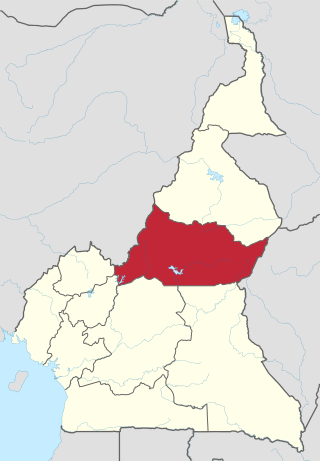
The Adamawa Region is a constituent region of the Republic of Cameroon. It borders the Centre and East regions to the south, the Northwest and West regions to the southwest, Nigeria to the west, the Central African Republic (CAR) to the east, and the North Region to the north.

<span class="mw-page-title-main">Bamenda</span> Place in Northwest, Cameroon

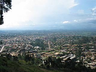
Bamenda, also known as Abakwa and Mankon Town, is a city in northwestern Cameroon and capital of the Northwest Region. The city has a population of about 2 million people and is located 366 km (227 mi) north-west of the Cameroonian capital, Yaoundé. Bamenda is known for its cool climate and scenic hilly location.

Articles related to Cameroon include:

Ngaoundéré, or N'Gaoundéré is the capital of the Adamawa Region of Cameroon. It had a population of 152,700 at the 2005 census. According to the film Les Mairuuwas – Maitre de l'eau produced by the University of Tromsø, the population has rapidly risen to 1,000,000 owing to mass immigration from the Central African Republic and the perceived danger from Boko Haram in northern Cameroon.

<span class="mw-page-title-main">Kumbo</span> Place in Northwest Region

Kumbo, also known as Kimbo, is the second-largest city in the North West Province of Cameroon and the capital of Bui Division. It lies about 2000m above sea level and is situated approximately 110 km away from Bamenda, on the Bamenda Highlands Ring Road. Kumbo has a population of 80,212 and is split into three distinctive hilly settlements of Tobin, Mbveh, and Squares. The town is known for horse racing and traditional medicine, and also for its palace, a market and two hospitals. Kumbo is the capital city of the Nso Kingdom of the Nso people. The lingua franca is Lamnso but Pidgin, English, Oku, Djottin, Fulfulde, French and Hausa are spoken.

<span class="mw-page-title-main">North Region (Cameroon)</span> Region of Cameroon

The North Region makes up 66,090 km2 of the northern half of The Republic of Cameroon. Neighbouring territories include the Far North Region to the north, the Adamawa Region to the south, Nigeria to the west, Chad to the east, and Central African Republic to the southeast. The city of Garoua is both the political and industrial capital. Garoua is Cameroon's third largest port, despite the fact that the Bénoué River upon which it relies is only navigable for short periods of the year.

<span class="mw-page-title-main">Outline of Cameroon</span> Overview of and topical guide to Cameroon

The following outline is provided as an overview of and topical guide to Cameroon:

<span class="mw-page-title-main">Cameroon Radio Television</span>

Cameroon Radio Television (CRTV) is a major radio and television broadcasting company in Cameroon.

<span class="mw-page-title-main">Evangelical Lutheran Church of Cameroon</span>

The Evangelical Lutheran Church of Cameroon (EELC) is a Lutheran denomination in Cameroon. The EELC was registered as a religious body in Cameroon in 1965 and currently has approximately 253,000 members in 1,300 congregations nationwide.

<span class="mw-page-title-main">Communes of Cameroon</span> Third-level units of administration in Cameroon

The Arrondissements of Cameroon are the third-level units of administration in Cameroon. The arrondissements are organised by divisions and sub divisions of each province.

Tibati is a town and commune in the Adamawa Region, Cameroon. The town and region are ruled by a local monarch, the Lamido.

<span class="mw-page-title-main">Government of Cameroon</span>

The Republic of Cameroon is a decentralized unitary state.

As of 31 August 2020, Cameroon hosted a total refugee population of approximately 421,700. Of these, 280,500 were from the Central African Republic, driven by war and insecurity. In the Far North Region, Cameroon hosts 114,300 Nigerian refugees, with the population sharing their already scarce resources with the refugees.

PWD Bamenda is a Cameroonian football club based in the City of Bamenda, Northwest Region They currently compete in the Elite One, the highest football league in Cameroon.

References

  1. 1 2 3 4 "Annual Medical Directory of Cameroon". Annuaire Medical. Archived from the original on January 25, 2021. Retrieved May 22, 2021.
  2. 1 2 3 4 5 6 7 8 9 10 11 12 13 14 15 16 17 18 19 20 21 22 23 24 25 26 27 28 29 30 31 32 33 34 35 36 37 38 39 40 41 42 43 44 45 46 47 48 49 50 51 52 53 54 55 56 57 58 59 60 61 62 63 64 65 66 67 68 69 70 71 72 73 74 75 76 77 78 79 80 81 82 83 84 85 86 87 88 89 90 91 92 93 94 95 96 97 98 99 100 101 102 103 104 105 106 107 108 109 110 111 112 113 114 115 116 117 118 119 120 121 122 123 124 125 126 127 128 129 130 131 132 133 134 135 136 137 138 139 140 141 142 143 144 145 146 147 148 149 150 151 152 153 154 155 156 157 158 159 160 161 162 163 164 165 166 167 168 169 170 171 172 173 174 175 176 177 178 179 180 181 182 183 184 185 186 "A spatial database of health facilities managed by the public health sector in sub-Saharan Africa". World Health Organization. February 11, 2019. Archived from the original on April 22, 2019. Retrieved May 8, 2020.
  3. 1 2 DeLancey, Mark D.; Mbuh, Rebecca Neh (30 April 2010). Historical Dictionary of the Republic of Cameroon. Scarecrow Press. p. 360. ISBN   978-0-8108-5824-4. Archived from the original on 27 June 2014. Retrieved 25 July 2012.
  4. MINSANTE, Cameroon Health Map 2016.
  5. Cameroon: Health Analytical Profile 2016
  6. 1 2 3 4 5 6 7 8 9 10 "Public Healthcare by Region Portal". Cameroonian Ministry of Public Health. Archived from the original on May 24, 2021. Retrieved May 24, 2021.
  7. 1 2 3 4 5 6 7 8 9 10 Coordinates are derived from Google Maps, Google Earth, or GEONAMES as referenced in the WHO database
  8. "Baptist Hospital Banyo". www.cbchealthservices.org. Archived from the original on 2019-05-25. Retrieved 2018-08-20.
  9. 1 2 3 4 5 6 7 8 9 10 "Physicians in Cameroon" (PDF). US Embassy, Cameroon. Archived (PDF) from the original on March 22, 2021. Retrieved May 22, 2021.
  10. 1 2 3 HILAIRE DE PRINCE POKAM. "Chinese Medicine in Cameroon". China Perspectives. Archived from the original on May 27, 2021. Retrieved May 25, 2021.
  11. "Hôpital Laquintinie". doualart.org. Archived from the original on 2016-10-30. Retrieved 2021-05-26.
  12. "Mboppi Baptist Hospital". Cameroon Baptist Convention Healthcare. Archived from the original on May 22, 2021. Retrieved May 26, 2021.
  13. "Daniel Muna Memorial Clinic". Polyclinique Bonanjo. Archived from the original on May 25, 2021. Retrieved May 25, 2021.
  14. 1 2 3 4 5 6 "Presbyterian Health Units in Cameroon". Presbyterian Church in Cameroon. Archived from the original on September 19, 2020. Retrieved May 26, 2021.
  15. "Hospital Meskine". Electives.net. Archived from the original on May 24, 2021. Retrieved May 24, 2021.
  16. "Bamenda Regional Hospital". Archived from the original on 2011-08-07. Retrieved November 1, 2011.,
  17. "Banso Baptist Hospital". Cameroon Baptist Convention Healthcare. Archived from the original on May 22, 2021. Retrieved May 26, 2021.
  18. "About Us". Grace Gardens Hospital. Archived from the original on May 26, 2021. Retrieved May 26, 2021.
  19. "Mbingo Baptist Hospital". Cameroon Baptist Convention Health Services. Archived from the original on May 22, 2021. Retrieved May 25, 2021.
  20. Nkfusai, C. N.; Cumber, S. N.; Bede, F.; Tambe, T. A.; Tsoka-Gwegweni, J. M. (2019). "Assessment of the knowledge of the modes of transmission and prevention of malaria among pregnant women attending antenatal clinic at the Nkwen Health Center Bamenda, Cameroon". The Pan African Medical Journal. 33: 137. doi:10.11604/pamj.2019.33.137.16896. PMC   6754843 . PMID   31558935.
  21. Giamberti, Alessandro; Butera, Gianfranco; Mve Mvondo, Charles; Cirri, Silvia; Varrica, Alessandro; Moussaidi, Nadia; Isgrò, Giuseppe; Ambassa, Jean Claude; Tantchou, Cabral; Giamberti, Giovanni; Frigiola, Alessandro (2018). "The Shisong Cardiac Center in Cameroon: An Example of a Long-Term Collaboration, Cooperation Toward Autonomy". Frontiers in Pediatrics. 6: 188. doi: 10.3389/fped.2018.00188 . PMC   6038727 . PMID   30018948.
  22. "Baptist Hospital Mutengene". University of Alabama at Birmingham. Archived from the original on May 26, 2021. Retrieved May 26, 2021.
  23. "Baptist Hospital Mutengene". Cameroon Baptist Convention Health Serivices. Archived from the original on May 22, 2021. Retrieved May 26, 2021.
  24. Tim Mbom, Francis (January 31, 2006). "Limbe Rotary Club Donates Hospital, Educational Equipment". Postnewsline.com. Archived from the original on September 27, 2011. Retrieved November 27, 2011.