List of lakes of Wyoming

Last updated
Map all coordinates using: OpenStreetMap  
Download coordinates as: KML

Following is a list of lakes in Wyoming . Information listed is taken from the infobox in the associated article unless otherwise specified.

NameLocationCoordinates
Amphitheater Lake Grand Teton National Park, Teton County 43°43′47″N110°46′52″W / 43.72972°N 110.78111°W / 43.72972; -110.78111 Coordinates: 43°43′47″N110°46′52″W / 43.72972°N 110.78111°W / 43.72972; -110.78111 [1]
Lake Alice Lincoln County 42°24.7′N110°44.7′W / 42.4117°N 110.7450°W / 42.4117; -110.7450
Bradley Lake Grand Teton National Park, Teton County 43°42′51″N110°45′18″W / 43.71417°N 110.75500°W / 43.71417; -110.75500
Dudley Lake Grand Teton National Park, Teton County 43°52′48″N110°46′54″W / 43.88000°N 110.78167°W / 43.88000; -110.78167 [2]
Emma Matilda Lake Grand Teton National Park, Teton County 43°53′11″N110°31′58″W / 43.88639°N 110.53278°W / 43.88639; -110.53278
Flaming Gorge Reservoir Sweetwater County 41°09′41″N109°33′04″W / 41.16139°N 109.55111°W / 41.16139; -109.55111
Fremont Lake Sublette County 42°56′37″N109°48′27″W / 42.94361°N 109.80750°W / 42.94361; -109.80750
Jackson Lake Grand Teton National Park, Teton County 43°54′02″N110°40′26″W / 43.90056°N 110.67389°W / 43.90056; -110.67389
Jenny Lake Grand Teton National Park, Teton County 43°45′50″N110°43′48″W / 43.76389°N 110.73000°W / 43.76389; -110.73000
Leigh Lake Grand Teton National Park, Teton County 43°48′43″N110°43′56″W / 43.81194°N 110.73222°W / 43.81194; -110.73222
New Fork Lake Sublette County 43°5′45″N109°56′47″W / 43.09583°N 109.94639°W / 43.09583; -109.94639
Phelps Lake Grand Teton National Park, Teton County 43°38′34″N110°47′41″W / 43.64278°N 110.79472°W / 43.64278; -110.79472
Lake Solitude Grand Teton National Park, Teton County 43°47′33″N110°50′41″W / 43.79250°N 110.84472°W / 43.79250; -110.84472
String Lake Grand Teton National Park, Teton County 43°47′16″N110°44′01″W / 43.78778°N 110.73361°W / 43.78778; -110.73361
Taggart Lake Grand Teton National Park, Teton County 43°42′15″N110°45′17″W / 43.70417°N 110.75472°W / 43.70417; -110.75472
Ocean Lake Fremont County 43°11′04″N108°36′02″W / 43.18444°N 108.60056°W / 43.18444; -108.60056
Two Ocean Lake Grand Teton National Park, Teton County 43°54′34″N110°31′25″W / 43.90944°N 110.52361°W / 43.90944; -110.52361
Wrangler Lake Yellowstone National Park, Park County 44°41′0″N110°26′5″W / 44.68333°N 110.43472°W / 44.68333; -110.43472
Willow Lake Sublette County 43°0′09″N109°52′09″W / 43.00250°N 109.86917°W / 43.00250; -109.86917
Yellowstone Lake Yellowstone National Park, Teton County 44°28′N110°22′W / 44.467°N 110.367°W / 44.467; -110.367

See also

Related Research Articles

<span class="mw-page-title-main">Wind River (Wyoming)</span> River in Wyoming, United States

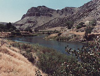
The Wind River is the name applied to the upper reaches of the Bighorn River in Wyoming in the United States. The Wind River is 185 miles (298 km) long. The two rivers are sometimes referred to as the Wind/Bighorn.

<span class="mw-page-title-main">Chippewa River (Michigan)</span> River in Michigan, United States

The Chippewa River is a stream in Michigan, United States, that runs 91.8 miles (147.7 km) through the central Lower Peninsula. The Chippewa is a tributary of the Tittabawassee River and is thus part of the Saginaw River drainage basin. The river is named after the Chippewa people.

Carp River is a 40.2-mile-long (64.7 km) river in Chippewa and Mackinac counties in the U.S. state of Michigan. 21.7 miles (34.9 km) of the river were added to the National Wild and Scenic Rivers System in 1992.

The Black River is a 41.1-mile-long (66.1 km) river on the Upper Peninsula of the U.S. state of Michigan, flowing mostly in Gogebic County into Lake Superior at 46°40′03″N90°02′57″W. Its source at 46°18′54″N90°01′15″W is a boreal wetland on the border with Iron County, Wisconsin. The northern section of the river, 14 miles (23 km) within the boundaries of the Ottawa National Forest, was designated a National Wild and Scenic River in 1992.

<span class="mw-page-title-main">Elk River Chain of Lakes Watershed</span> Drainage basin in Michigan, United States

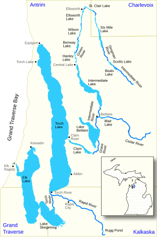
The Elk River Chain of Lakes Watershed is a 75-mile-long (121 km) waterway consisting of 14 lakes and connecting rivers in the northwestern section of the Lower Peninsula of the U.S. state of Michigan, which empty into Lake Michigan.

<span class="mw-page-title-main">Canyons of the Teton Range</span>

The canyons of the Teton Range lie almost entirely within Grand Teton National Park in the U.S. state of Wyoming. Ranging from 9 miles (14 km) to less than 1 mile (1.6 km) in length and up to 6,000 feet (1,800 m) deep, the canyons were carved primarily by glaciers over the past 250,000 years. The canyons in the Teton Range descend in altitude generally west to east and many have lakes at their outlets. The lakes were created by terminal moraines left behind by the now retreated glaciers. A few of the canyons have small glaciers that were created mostly during the Little Ice Age (1550-1850). Fast retreating Schoolroom Glacier is a tiny glacier located at the head of the South Cascade Canyon. Most of the canyons have streams from which rain and snowmelt flow towards Jackson Hole valley, and due to the sometimes rapid altitude descent, waterfalls are common. The canyons offer the easiest hiking access into the Teton Range.

Green Lakes Mountain (10,240 feet is located in the Teton Range in the U.S. state of Wyoming. The peak is on the border of Grand Teton National Park and the Jedediah Smith Wilderness of Caribou-Targhee National Forest. Green Lakes Mountain is at the head of Moran Canyon and 1 mile SSW of Dry Ridge Mountain.

References

  1. "Amphitheater Lake". Geographic Names Information System . United States Geological Survey, United States Department of the Interior . Retrieved 2011-12-23.
  2. "Dudley Lake". Geographic Names Information System . United States Geological Survey, United States Department of the Interior . Retrieved August 24, 2022.