Sublette County, Wyoming

Last updated

Sublette County
Overlooking Pinedale, WY from the east in the winter, Dec 2016.jpg
Map of Wyoming highlighting Sublette County.svg
Location within the U.S. state of Wyoming
Wyoming in United States.svg
Wyoming's location within the U.S.
Coordinates: 42°46′N109°55′W / 42.76°N 109.92°W / 42.76; -109.92
CountryFlag of the United States.svg United States
StateFlag of Wyoming.svg  Wyoming
FoundedFebruary 15, 1921(authorized)
1923 (organized)
Named for William Sublette
Seat Pinedale
Largest townPinedale
Area
  Total4,936 sq mi (12,780 km2)
  Land4,887 sq mi (12,660 km2)
  Water49 sq mi (130 km2)  1.0%
Population
 (2020)
  Total8,728
  Density1.8/sq mi (0.68/km2)
Time zone UTC−7 (Mountain)
  Summer (DST) UTC−6 (MDT)
Congressional district At-large
Website www.sublettewyo.com

Sublette County is a county in the U.S. state of Wyoming. As of the 2020 United States Census, the population was 8,728. [1] The county seat is Pinedale. [2] It is a sparsely populated rural county in western Wyoming, along the Green River.

Contents

History

Sublette County was created February 15, 1921, of land partitioned from Fremont and Lincoln counties. Its governing organization was completed by 1923. [3] Before settlement, the western Wyoming mountains were traversed and harvested by fur trappers and traders. Sublette County is named for one of those early characters, William Lewis Sublette. [4] Today the county celebrates its fur trade heritage with the Museum of the Mountain Man in Pinedale. In the early 1900s the majority of the population in what is today Sublette County were first generation immigrants from England and Germany. A majority of the population in Sublette County supported America's entry into World War I and at the time the county was known for its "pro-British" sentiments. The German immigrants in the county were not anti-British, and most of them were outspoken about England being their favorite foreign country other than Germany, however they did support neutrality and want America to stay out of the war. Even during the war, relations between first generation English immigrants and first generation German immigrants were known for being exceptionally cordial (Sublette County, Wyoming stood out in this regard because this was not the norm nation-wide). [5]

Geography

Wind River Range from US 191 just south of Daniel, Wyoming Wind River from 191.jpg
Wind River Range from US 191 just south of Daniel, Wyoming

According to the US Census Bureau, the county has a total area of 4,936 square miles (12,780 km2), of which 4,887 square miles (12,660 km2) is land and 49 square miles (130 km2) (1.0%) is water. [6]

Adjacent counties

National protected areas

At present, Bridger National Forest and Teton National Forest are administratively combined into the Bridger-Teton National Forest . Sublette County contains portions of both original forests.

Demographics

Historical population
CensusPop.Note
1930 1,944
1940 2,77842.9%
1950 2,481−10.7%
1960 3,77852.3%
1970 3,755−0.6%
1980 4,54821.1%
1990 4,8436.5%
2000 5,92022.2%
2010 10,24773.1%
2020 8,728−14.8%
2023 (est.)8,969 [7] 2.8%
US Decennial Census [8]
1870–2000 [9] 2010–2016 [1]

2020 census

As of the 2020 United States Census, there were 8,728 people and 3,337 households county. [10]

2010 census

As of the 2010 United States Census, there were 10,247 people, 3,906 households, and 2,594 families in the county. [10] The population density was 2.1 people per square mile (0.81 people/km2). There were 5,770 housing units at an average density of 1.2 units per square mile (0.46 units/km2). [11] The racial makeup of the county was 93.2% white, 0.8% American Indian, 0.5% Asian, 0.3% black or African American, 3.7% from other races, and 1.4% from two or more races. Those of Hispanic or Latino origin made up 6.9% of the population. [10] In terms of ancestry, 31.8% were German, 22.0% were English, 11.3% were Irish, 6.3% were American, and 5.1% were Scottish. [12]

Of the 3,906 households, 32.0% had children under the age of 18 living with them, 56.3% were married couples living together, 5.1% had a female householder with no husband present, 33.6% were non-families, and 25.6% of all households were made up of individuals. The average household size was 2.48 and the average family size was 2.99. The median age was 38.3 years. [10]

The median income for a household in the county was $70,147 and the median income for a family was $81,389. Males had a median income of $51,125 versus $31,940 for females. The per capita income for the county was $31,433. About 2.7% of families and 4.2% of the population were below the poverty line, including 2.2% of those under age 18 and 1.1% of those age 65 or over. [13]

Communities

Towns

Census-designated places

Unincorporated community

Government and politics

Like most of Wyoming, Sublette County is overwhelmingly Republican. Since it was created in 1921, the solitary Democrat to carry the county was Franklin D. Roosevelt, who won a majority against Herbert Hoover in 1932 and a twenty-nine vote plurality against Alf Landon four years later. Since 1968 no Democrat has reached twenty-nine percent of Sublette County's ballots, and the only occasions a Republican has failed to pass seventy percent were when Ross Perot took substantial numbers of votes in 1992 and 1996.

United States presidential election results for Sublette County, Wyoming [15]
Year Republican Democratic Third party
No.%No.%No.%
2020 3,95779.62%88217.75%1312.64%
2016 3,40977.65%64414.67%3377.68%
2012 3,47279.34%76717.53%1373.13%
2008 3,31676.12%93621.49%1042.39%
2004 2,84777.98%73019.99%742.03%
2000 2,62481.59%45814.24%1344.17%
1996 1,82962.15%67723.00%43714.85%
1992 1,16845.38%53620.82%87033.80%
1988 1,63672.81%57625.63%351.56%
1984 1,97682.47%38916.24%311.29%
1980 1,53873.87%35717.15%1878.98%
1976 1,28470.32%52828.92%140.77%
1972 1,34881.55%30418.39%10.06%
1968 1,15268.25%31018.36%22613.39%
1964 90053.22%79146.78%00.00%
1960 97860.22%64639.78%00.00%
1956 90171.96%35128.04%00.00%
1952 1,01374.54%34425.31%20.15%
1948 62255.24%49644.05%80.71%
1944 68359.24%47040.76%00.00%
1940 77154.99%62744.72%40.29%
1936 63847.68%66749.85%332.47%
1932 51243.69%63354.01%272.30%
1928 57364.02%31635.31%60.67%
1924 57067.38%18321.63%9310.99%

Sublette County is managed by a county commission with three members. In 2011, Sublette County residents petitioned voters to approve an increase in this number to five as allowed under Wyoming law. The ballot initiative passed and five commissioners were to be seated during the 2012 election cycle. [16]

In early 2012, another ballot initiative was presented to voters requesting their approval to decrease the number of county commissioners back to three even before seating the two additional commissioners. This second special election, held on May 8, 2012, returned the commission to its previous number of three. [17]

Media references

See also

Related Research Articles

<span class="mw-page-title-main">Teton County, Wyoming</span> County in Wyoming, United States

Teton County is a county in the U.S. state of Wyoming. As of the 2020 United States Census, the population was 23,331. Its county seat is Jackson. Its west boundary line is also the Wyoming state boundary shared with Idaho and the southern tip of Montana. Teton County is part of the Jackson, WY-ID Micropolitan Statistical Area.

<span class="mw-page-title-main">Park County, Wyoming</span> County in Wyoming, United States

Park County is a county in the U.S. state of Wyoming. As of the 2020 United States Census, the population was 29,624. The county seat is Cody.

<span class="mw-page-title-main">Lincoln County, Wyoming</span> County in Wyoming, United States

Lincoln County is a county in the U.S. state of Wyoming. As of the 2020 United States Census, the population was 19,581. Its county seat is Kemmerer. Its western border abuts the eastern borders of the states of Idaho and Utah.

<span class="mw-page-title-main">Laramie County, Wyoming</span> County in Wyoming, United States

Laramie County is a county located at the southeast corner of the state of Wyoming. As of the 2020 United States Census, the population was 100,512 or 17.4% of the state's total 2020 population, making it the most populous county in Wyoming, but the least populous county in the United States to be the most populous in its state.

<span class="mw-page-title-main">Fremont County, Wyoming</span> County in Wyoming, United States

Fremont County is a county in the U.S. state of Wyoming. As of the 2020 United States census, the population was 39,234, making it the fifth-most populous county in Wyoming. Its county seat is Lander. The county was founded in 1884 and is named for John C. Frémont, a general, explorer, and politician. It is roughly the size of the state of Vermont.

<span class="mw-page-title-main">Big Horn County, Wyoming</span> County in Wyoming, United States

Big Horn County is a county in the U.S. state of Wyoming. As of the 2020 United States Census, the population was 11,521. The county seat is Basin. Its north boundary abuts the south boundary of Montana.

<span class="mw-page-title-main">Albany County, Wyoming</span> County in Wyoming, United States

Albany County is a county in the U.S. state of Wyoming. As of the 2020 United States Census, the population was 37,066. Its county seat is Laramie, the site of the University of Wyoming. Its south border lies on the northern Colorado state line.

<span class="mw-page-title-main">Teton County, Montana</span> County in Montana, United States

Teton County is a county in the U.S. state of Montana. As of the 2020 census, the population was 6,226. Its county seat is Choteau. The county was founded in 1893.

<span class="mw-page-title-main">Teton County, Idaho</span> County in Idaho, United States

Teton County is a county located in the U.S. state of Idaho. As of the 2020 census, the population was 11,630. The county seat is Driggs, and the largest city is Victor. The county was established in 1915 and was named after the Teton Mountains to the east.

<span class="mw-page-title-main">Big Piney, Wyoming</span> Town in Wyoming, United States

Big Piney is a town in Sublette County, Wyoming, United States. The population was 552 at the 2010 census.

<span class="mw-page-title-main">Bondurant, Wyoming</span> CDP in Wyoming, United States

Bondurant is a census-designated place (CDP) in Sublette County, Wyoming, United States. The population was 93 at the 2010 census. The town was named after B. F. Bondurant.

<span class="mw-page-title-main">Boulder, Wyoming</span> CDP in Wyoming, United States

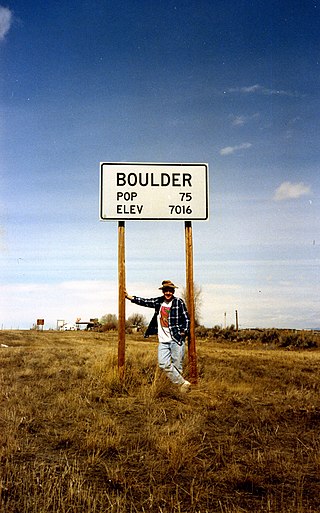
Boulder is a census-designated place (CDP) in Sublette County, Wyoming, United States. The population was 170 at the 2010 census.

<span class="mw-page-title-main">Calpet, Wyoming</span> Unincorporated community in Wyoming, United States

Calpet is an unincorporated community in Sublette County, Wyoming, United States. The population was 7 at the 2000 census, when it was a census-designated place (CDP).

<span class="mw-page-title-main">Cora, Wyoming</span> CDP in Wyoming, United States

Cora is a census-designated place (CDP) in Sublette County, Wyoming. The population was 114 at the 2020 census.

<span class="mw-page-title-main">Marbleton, Wyoming</span> Town in Wyoming, United States

Marbleton is a town in Sublette County, Wyoming, United States. The population was 1,094 at the 2010 census.

<span class="mw-page-title-main">Pinedale, Wyoming</span> Town in Wyoming, United States

Pinedale is a town in and the county seat of Sublette County, Wyoming, United States. The population was 2,030 at the 2010 census. Pinedale is an important hunting outfitting town and a gateway to the Wind River Mountains. Additionally, Pinedale is near several large natural gas fields, including the Pinedale Anticline and Jonah Field. Attractions include the Museum of the Mountain Man, Green River Rendezvous Days, White Pine Ski Area, the Pinedale Aquatic Center and the Town Park System along the Pine Creek Corridor in the middle of town. The mayor is Matt Murdock, who was elected in 2018.

Alta is a census-designated place (CDP) in Teton County, Wyoming, United States. The population was 429 at the 2020 census. It is part of the Jackson, WY–ID Micropolitan Statistical Area, and it is located between Driggs, Idaho and the Grand Targhee ski resort.

<span class="mw-page-title-main">Hoback, Wyoming</span> CDP in Wyoming, United States

Hoback is a census-designated place (CDP) in Teton County, Wyoming, United States. The population was 1,176 at the 2010 census. It is part of the Jackson, WY–ID Micropolitan Statistical Area. The town is named for John Hoback, a mountain man who guided the Astor party through the area in 1811.

<span class="mw-page-title-main">Jackson, Wyoming</span> Town in Wyoming, United States

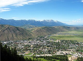
Jackson is a town in Teton County, Wyoming, United States. The population was 10,760 at the 2020 census, up from 9,577 in 2010. It is the largest town in Teton County and its county seat. Jackson is the principal town of the Jackson, WY-ID Micropolitan Statistical Area, which includes Teton County in Wyoming and Teton County in Idaho. The town, often familiarly or mistakenly called Jackson Hole, derives its name from the valley in which it is located. Jackson is a popular tourist destination due to its proximity to the ski resorts Jackson Hole Mountain, Snow King Mountain, and Grand Targhee, as well as Grand Teton National Park and Yellowstone National Park.

<span class="mw-page-title-main">Teton Village, Wyoming</span> CDP in Wyoming, United States

Teton Village is a census-designated place (CDP) in Teton County, Wyoming, United States. The population was 517 at the 2020 census. The village surrounds the base of the Jackson Hole Mountain Resort. It is accessed from nearby Jackson and the surrounding area via the Moose-Wilson Road.

References

  1. 1 2 "State & County QuickFacts". US Census Bureau. Retrieved January 25, 2014.
  2. "Find a County". National Association of Counties. Retrieved June 7, 2011.
  3. Long, John H., ed. (2004). "Wyoming: Individual County Chronologies". Wyoming Atlas of Historical County Boundaries. The Newberry Library . Retrieved August 19, 2015.
  4. Urbanek, Mae (1988). Wyoming Place Names. Missoula MT: Mountain Press Pub. Co. ISBN   0-87842-204-8.
  5. Wyoming's Last Frontier, Sublette County, Wyoming: A Settlement History by Robert G. Rosenberg pg. 19
  6. "2010 Census Gazetteer Files". US Census Bureau. August 22, 2012. Retrieved August 18, 2015.
  7. "Annual Estimates of the Resident Population for Counties: April 1, 2020 to July 1, 2023". United States Census Bureau. Retrieved March 24, 2024.
  8. "US Decennial Census". US Census Bureau. Retrieved August 18, 2015.
  9. "Historical Decennial Census Population for Wyoming Counties, Cities, and Towns". Wyoming Department of Administration & Information, Division of Economic Analysis. Retrieved January 25, 2014.
  10. 1 2 3 4 "Profile of General Population and Housing Characteristics: 2010 Demographic Profile Data". US Census Bureau. Archived from the original on February 13, 2020. Retrieved January 12, 2016.
  11. "Population, Housing Units, Area, and Density: 2010 - County". US Census Bureau. Archived from the original on February 13, 2020. Retrieved January 12, 2016.
  12. "Selected Social Characteristics in the US – 2006-2010 American Community Survey 5-Year Estimates". US Census Bureau. Archived from the original on February 13, 2020. Retrieved January 12, 2016.
  13. "Selected Economic Characteristics – 2006-2010 American Community Survey 5-Year Estimates". US Census Bureau. Archived from the original on February 13, 2020. Retrieved January 12, 2016.
  14. "Calpet WY Google Maps (accessed 13 January 2019)".
  15. Leip, David. "Atlas of US Presidential Elections". uselectionatlas.org. Retrieved April 5, 2018.
  16. "Sublette County voters expand county commission". News Article. Billings Gazette. August 2011. Retrieved May 9, 2012.
  17. "The Three's Have It In Sublette County". News Article. Sublette Times. May 2012. Retrieved May 9, 2012.
  18. Fuller, Alexandra Letter from Wyoming: Boomtown Blues, The New Yorker p. 35 (February 5, 2007)
  19. Roueche, Berton, Reporter at Large: Something About a River, The New Yorker p. 105 (October 23, 1965)

42°46′N109°55′W / 42.76°N 109.92°W / 42.76; -109.92