Rawlins, Wyoming

Last updated

Rawlins, Wyoming
DowntownRawlins.jpg
Downtown Rawlins, looking north from I-80
Carbon County Wyoming Incorporated and Unincorporated areas Rawlins Highlighted 5663900.svg
Location of Rawlins in Carbon County, Wyoming.
Usa edcp location map.svg
Red pog.svg
Rawlins, Wyoming
Location in the United States
Coordinates: 41°47′25″N107°14′3″W / 41.79028°N 107.23417°W / 41.79028; -107.23417
CountryFlag of the United States.svg  United States
State Flag of Wyoming.svg  Wyoming
County Flag of Carbon County, Wyoming.gif Carbon
Government
  MayorTerry Weickum [1]
Area
[2]
  Total8.29 sq mi (21.46 km2)
  Land8.25 sq mi (21.36 km2)
  Water0.04 sq mi (0.10 km2)
Elevation
6,834 ft (2,083 m)
Population
 (2020) [3]
  Total8,221
  Estimate 
(2021) [4]
8,298
  Density996.7/sq mi (353.7/km2)
Time zone UTC−7 (Mountain (MST))
  Summer (DST) UTC−6 (MDT)
ZIP code
82301
Area code 307
FIPS code 56-63900 [5]
GNIS feature ID1593213 [6]
Website www.rawlins-wyoming.com

Rawlins is a city in Carbon County, Wyoming, United States. The population was 8,221 at the 2020 census. It is the county seat of Carbon County. [7] It was named for Union General John Aaron Rawlins, who camped in the locality in 1867. [8]

Contents

Demographics

"Officers quarters at Ft. Rawlins, Wyoming, May 7, 1877." "Officers quarters at Ft. Rawlins, Wyoming, May 7, 1877." Two men and a woman holding a baby sit in front of the crude structure - NARA - 531107.gif
"Officers quarters at Ft. Rawlins, Wyoming, May 7, 1877."
The Rochelle Ranch Golf Course in Rawlins, Wyoming. Rochelle Ranch Golf Course.jpg
The Rochelle Ranch Golf Course in Rawlins, Wyoming.
Historical population
CensusPop.Note
1870 612
1880 1,451137.1%
1890 2,23554.0%
1900 2,3173.7%
1910 4,25683.7%
1920 3,969−6.7%
1930 4,86822.7%
1940 5,53113.6%
1950 7,41534.1%
1960 8,96820.9%
1970 7,855−12.4%
1980 11,54747.0%
1990 9,380−18.8%
2000 8,538−9.0%
2010 9,2598.4%
2020 8,221−11.2%
[9]

2010 census

As of the census of 2010, there were 9,259 people, 3,443 households, and 2,206 families living in the city. [3] The population density was 1,123.7 inhabitants per square mile (433.9/km2). There were 3,960 housing units at an average density of 480.6 per square mile (185.6/km2). The racial makeup of the city was 84.7% White, 1.1% African American, 1.3% Native American, 1.0% Asian, 0.1% Pacific Islander, 9.2% from other races, and 2.7% from two or more races. Hispanic or Latino of any race were 24.3% of the population.

There were 3,443 households, of which 35.5% had children under the age of 18 living with them, 48.2% were married couples living together, 10.2% had a female householder with no husband present, 5.6% had a male householder with no wife present, and 35.9% were non-families. 29.0% of all households were made up of individuals, and 7.3% had someone living alone who was 65 years of age or older. The average household size was 2.47 and the average family size was 3.04.

The median age in the city was 34.3 years. 25.5% of residents were under the age of 18; 9.5% were between the ages of 18 and 24; 29% were from 25 to 44; 26.8% were from 45 to 64; and 9.3% were 65 years of age or older. The gender makeup of the city was 54.7% male and 45.3% female.

2000 census

As of the census [5] of 2000, there were 8,538 people, 3,320 households, and 2,237 families living in the city. The population density was 1,153.4 people per square mile (445.5/km2). There were 3,860 housing units at an average density of 521.4 per square mile (201.4/km2). The racial makeup of the city was 85.86% White, 0.81% African American, 1.46% Native American, 0.84% Asian, 0.09% Pacific Islander, 8.28% from other races, and 2.65% from two or more races. Hispanic or Latino of any race were 21.05% of the population.

There were 3,320 households, out of which 33.9% had children under the age of 18 living with them, 52.6% were married couples living together, 10.5% had a female householder with no husband present, and 32.6% were non-families. 26.9% of all households were made up of individuals, and 8.6% had someone living alone who was 65 years of age or older. The average household size was 2.45 and the average family size was 2.97.

In the city, the population was spread out, with 26.0% under the age of 18, 10.1% from 18 to 24, 29.4% from 25 to 44, 24.2% from 45 to 64, and 10.3% who were 65 years of age or older. The median age was 36 years. For every 100 females, there were 111.5 males. For every 100 females age 18 and over, there were 112.8 males.

The median income for a household in the city was $36,600, and the median income for a family was $42,137. Males had a median income of $33,179 versus $22,580 for females. The per capita income for the city was $17,887. About 10.4% of families and 13.7% of the population were below the poverty line, including 18.2% of those under age 18 and 17.7% of those age 65 or over.

Geography

Rawlins is located in Carbon County at 41°47′25″N107°14′3″W / 41.79028°N 107.23417°W / 41.79028; -107.23417 (41.790397, -107.234297). [10]

According to the United States Census Bureau, the city has a total area of 8.28 square miles (21.45 km2), of which 8.24 square miles (21.34 km2) is land and 0.04 square miles (0.10 km2) is water. [11] The city is approximately 6800 feet (2073 m) above sea level.

Climate

Rawlins' climate is semi-arid (Köppen climate classification BSk ).

Climate data for Rawlins Municipal Airport, Wyoming (1991–2020 normals, extremes 1951–present)
MonthJanFebMarAprMayJunJulAugSepOctNovDecYear
Record high °F (°C)56
(13)
58
(14)
73
(23)
79
(26)
88
(31)
97
(36)
98
(37)
98
(37)
95
(35)
81
(27)
70
(21)
60
(16)
98
(37)
Mean maximum °F (°C)45.5
(7.5)
48.6
(9.2)
60.2
(15.7)
72.0
(22.2)
80.4
(26.9)
89.5
(31.9)
93.7
(34.3)
91.5
(33.1)
86.3
(30.2)
74.7
(23.7)
59.7
(15.4)
47.7
(8.7)
94.4
(34.7)
Mean daily maximum °F (°C)31.5
(−0.3)
33.9
(1.1)
45.1
(7.3)
53.5
(11.9)
64.2
(17.9)
76.6
(24.8)
85.1
(29.5)
82.6
(28.1)
72.3
(22.4)
56.8
(13.8)
41.8
(5.4)
31.3
(−0.4)
56.2
(13.4)
Daily mean °F (°C)22.3
(−5.4)
24.2
(−4.3)
33.6
(0.9)
40.4
(4.7)
49.8
(9.9)
59.9
(15.5)
67.9
(19.9)
65.8
(18.8)
56.5
(13.6)
43.6
(6.4)
31.3
(−0.4)
22.1
(−5.5)
43.1
(6.2)
Mean daily minimum °F (°C)13.2
(−10.4)
14.5
(−9.7)
22.0
(−5.6)
27.3
(−2.6)
35.5
(1.9)
43.2
(6.2)
50.8
(10.4)
49.1
(9.5)
40.7
(4.8)
30.4
(−0.9)
20.8
(−6.2)
12.8
(−10.7)
30.0
(−1.1)
Mean minimum °F (°C)−12.1
(−24.5)
−9.2
(−22.9)
1.4
(−17.0)
12.1
(−11.1)
22.1
(−5.5)
32.8
(0.4)
41.4
(5.2)
38.3
(3.5)
26.5
(−3.1)
11.6
(−11.3)
−0.5
(−18.1)
−9.9
(−23.3)
−19.6
(−28.7)
Record low °F (°C)−36
(−38)
−36
(−38)
−21
(−29)
−11
(−24)
10
(−12)
21
(−6)
32
(0)
28
(−2)
8
(−13)
−20
(−29)
−24
(−31)
−35
(−37)
−36
(−38)
Average precipitation inches (mm)0.42
(11)
0.48
(12)
0.66
(17)
1.26
(32)
1.46
(37)
0.87
(22)
0.72
(18)
0.73
(19)
0.89
(23)
0.68
(17)
0.47
(12)
0.40
(10)
9.04
(230)
Average snowfall inches (cm)8.0
(20)
8.2
(21)
8.2
(21)
7.6
(19)
1.7
(4.3)
0.2
(0.51)
0.0
(0.0)
0.0
(0.0)
1.1
(2.8)
3.5
(8.9)
8.1
(21)
7.5
(19)
54.1
(137.51)
Average precipitation days (≥ 0.01 in)5.56.16.810.010.16.65.76.26.46.85.96.082.1
Average snowy days (≥ 0.1 in)6.76.67.15.51.30.10.00.00.52.25.66.942.5
Source: NOAA (snow, snow days 19512000) [12] [13]

Government and infrastructure

The Wyoming Department of Corrections Wyoming State Penitentiary is located in Rawlins. [14] The facility was operated by the Wyoming Board of Charities and Reform until that agency was dissolved as a result of a state constitutional amendment passed in November 1990. [15]

Wyoming Frontier Prison, operational from 1901 until 1981 Rawlins Jail.JPG
Wyoming Frontier Prison, operational from 1901 until 1981

The United States Postal Service operates the Rawlins Post Office. [16]

Education

Residents are zoned to schools in the Carbon County School District#1 [17]

All residents are zoned to Rawlins Elementary School (elementary students formerly went to either Pershing, Mountain View, Sunny Side, or Highlands Hills Elementary School), Rawlins Middle School and Rawlins High School; Rawlins also offers an alternative school, the Carbon County Co-operative High School.

Western Wyoming Community College also offers outreach programs through the Carbon County Higher Education Center. The main campus is housed in the former Sunny Side Elementary School building.

Rawlins has a public library, a branch of the Carbon County Library System. [18]

Media

Rawlins is served by one print newspaper, the Rawlins Daily Times.

The town's two radio stations, KRAL and KIQZ have both been silent for some time. The stations are owned by Mt. Rushmore Broadcasting, Inc. Sources connected to the FCC say, "...that any station owned or operated by Mt. Rushmore Broadcasting will "not likely" have their licenses renewed once they expire, due to the history of "past violations and cavalier attitude(s) towards following and maintaining" rules and regulations, and that this and other Mt. Rushmore stations could have their broadcasting rights taken away "at almost any moment." In early 2015, it was reported that staff had unexpectedly resigned, and there was difficulty finding new employees.

Transportation

Highways

Interstate highways:

I-80.svg I-80

U.S. highways:

US 30.svg US 30

US 287.svg US 287

Wyoming state highways:

WY-71.svg WYO 71

WY-78.svg WYO 78

WY-789.svg WYO 789

Scheduled bus service

Scheduled bus service is offered by Greyhound Bus Lines.

Airport

The city of Rawlins is served by Rawlins Municipal Airport (Harvey Field).

Railroads

The Union Pacific Railroad provides freight service to Rawlins. Amtrak's Pioneer served the city from 1991 through 1997. While there is a proposal to re-start the service as of Jan 2024 [19] , there is currently no scheduled passenger rail service.

"Rawlins Red"

"Rawlins Red" is a red pigment containing hematite, an oxide of iron that was mined near Rawlins. Paint containing Rawlins Red has anti-rust properties and is thought to have been used as the original paint on the Brooklyn Bridge. [20]

Republic of Texas

Rawlins displays a historical marker denoting the northernmost border of the Republic of Texas, which claimed land as far north as Carbon County. [21]

Notable people

Related Research Articles

<span class="mw-page-title-main">Sweetwater County, Wyoming</span> County in Wyoming, United States

Sweetwater County is a county in southwestern Wyoming, United States. As of the 2020 United States Census, the population was 42,272, making it the fourth-most populous county in Wyoming. Its county seat is Green River. By area, it is the largest county in Wyoming. Its southern boundary line abuts the north lines of the states of Colorado and Utah.

<span class="mw-page-title-main">Niobrara County, Wyoming</span> County in the United States

Niobrara County is a county in the U.S. state of Wyoming. As of the 2020 United States Census, the population was 2,467, making it the least populous county in Wyoming. Its county seat is Lusk. Its eastern boundary abuts the west lines of the states of Nebraska and South Dakota.

<span class="mw-page-title-main">Natrona County, Wyoming</span> County in Wyoming, United States

Natrona County is a county in the U.S. state of Wyoming. As of the 2020 United States Census, the population was 79,955, making it the second-most populous county in Wyoming. Its county seat is Casper.

<span class="mw-page-title-main">Goshen County, Wyoming</span> County in Wyoming, United States

Goshen County is a county in the U.S. state of Wyoming. As of the 2020 United States Census, the population was 12,498. Its county seat is Torrington. The eastern boundary of the County borders the Nebraska state line.

<span class="mw-page-title-main">Carbon County, Wyoming</span> County in Wyoming, United States

Carbon County is a county in the U.S. state of Wyoming. As of the 2020 United States Census, the population was 14,537. Its county seat is Rawlins. Its south border abuts the north line of Colorado.

<span class="mw-page-title-main">Sinclair, Wyoming</span> Town in Wyoming, United States

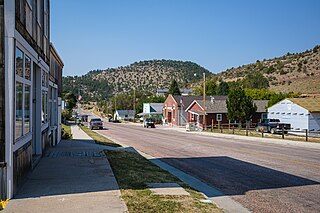
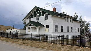
Sinclair is a town in Carbon County, Wyoming, United States.

<span class="mw-page-title-main">Jeffrey City, Wyoming</span> Census-designated place in Wyoming, United States

Jeffrey City is a former uranium mining boomtown located in Fremont County, in the central part of the U.S. state of Wyoming. The town is known in Wyoming and the American West as symbol of a boomtown that went "bust" very quickly, as the mine was shut down in 1982 and over 95% of the inhabitants left the town within three years. The population was 58 at the 2010 census, far lower than its onetime population of several thousand people. For statistical purposes, the United States Census Bureau has defined Jeffrey City as a census-designated place (CDP).

<span class="mw-page-title-main">Huntley, Wyoming</span> CDP in Wyoming, United States

Huntley is a census-designated place (CDP) in Goshen County, Wyoming, United States. The population was 30 according to the 2010 census.

<span class="mw-page-title-main">Lingle, Wyoming</span> Town in Wyoming, United States

Lingle is a town in Goshen County, Wyoming, United States. The population was 468 at the 2010 census.

<span class="mw-page-title-main">Torrington, Wyoming</span> City in Wyoming, United States

Torrington is a city in, and the county seat of, Goshen County, Wyoming, United States. The population was 6,501 at the 2010 census.

<span class="mw-page-title-main">Yoder, Wyoming</span> Town in Wyoming, United States

Yoder is a town in Goshen County, Wyoming, United States. The population was 131 at the 2020 census.

<span class="mw-page-title-main">Thermopolis, Wyoming</span> Town in Wyoming, United States

Thermopolis is the county seat and most populous town in Hot Springs County, Wyoming, United States. As of the 2020 U.S. Census, the town population was 2,725.

<span class="mw-page-title-main">Buffalo, Wyoming</span> City in Wyoming, United States

Buffalo is a city in Johnson County, Wyoming, United States. The city is located almost equidistant between Yellowstone Park and Mount Rushmore. The population was 4,415 at the 2020 census, down from 4,585 at the 2010 census. It is the county seat of Johnson County. The city has experienced an economic boom due to methane production from the Coal Bed Methane Extraction method used in the Powder River Basin and surrounding areas. However, with the decline of methane production, Buffalo's population has stabilized since the 2010 Census. Even though energy is a vital part of its economy, agriculture, tourism, and recreation are three other major components. Buffalo is located at the foot of the Bighorn Mountains.

<span class="mw-page-title-main">Cokeville, Wyoming</span> Town in Wyoming, United States

Cokeville is a town in Lincoln County, Wyoming, United States. The population was 502 at the 2020 census. The town is known for the Cokeville Elementary School hostage crisis.

<span class="mw-page-title-main">Kemmerer, Wyoming</span> City in Wyoming, United States

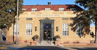
Kemmerer is the largest city in and the county seat of Lincoln County, Wyoming, United States. Its population was 2,415 at the 2020 census.

<span class="mw-page-title-main">Lance Creek, Wyoming</span> CDP in Wyoming, United States

Lance Creek is a census-designated place (CDP) in Niobrara County, Wyoming, United States. The population was 43 at the 2010 census. Lance Creek is the namesake of the Lance Formation, a rock formation from the Late Cretaceous that has yielded fossils from a diverse number of species.

<span class="mw-page-title-main">Hartville, Wyoming</span> Town in Wyoming, United States

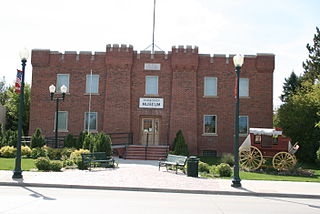
Hartville is a town in Platte County, Wyoming, United States. The population was 62 at the 2010 census.

<span class="mw-page-title-main">Wheatland, Wyoming</span> Town in Wyoming, United States

Wheatland is a town in and the county seat of Platte County in southeastern Wyoming, United States. The population was 3,627 at the 2010 census.

<span class="mw-page-title-main">Bairoil, Wyoming</span> Town in Wyoming, United States

Bairoil is a town in Sweetwater County, Wyoming, United States. The population was 68 at the 2020 census.

<span class="mw-page-title-main">Wamsutter, Wyoming</span> Town in Wyoming, United States

Wamsutter is a town in Sweetwater County, Wyoming, United States. The population was 203 at the 2020 census.

References

  1. Searcey, Dionne; Rasmussen, Benjamin (March 3, 2021). "Wyoming Coal Country Pivots, Reluctantly, to Wind Farms". The New York Times. Retrieved March 4, 2021.
  2. "2019 U.S. Gazetteer Files". United States Census Bureau. Retrieved August 7, 2020.
  3. 1 2 "U.S. Census website". United States Census Bureau . Retrieved December 14, 2012.
  4. "Population and Housing Unit Estimates". United States Census Bureau. May 24, 2020. Retrieved May 27, 2020.
  5. 1 2 "U.S. Census website". United States Census Bureau . Retrieved January 31, 2008.
  6. "US Board on Geographic Names". United States Geological Survey. October 25, 2007. Retrieved January 31, 2008.
  7. "Find a County". National Association of Counties. Retrieved June 7, 2011.
  8. Stewart, George R. (1970) American Place-Names, p. 401, New York, NY: Oxford University Press. The city is known as the only Wyoming county seat to originally be a part of the Republic of Texas before the area was given to the various territories in 1850.
  9. "Historical Decennial Census Population for Wyoming Counties, Cities, and Towns". Wyoming Department of State / U.S. Census Bureau. Retrieved June 30, 2008.
  10. "US Gazetteer files: 2010, 2000, and 1990". United States Census Bureau. February 12, 2011. Retrieved April 23, 2011.
  11. "US Gazetteer files 2010". United States Census Bureau. Archived from the original on January 25, 2012. Retrieved December 14, 2012.
  12. "NOWData - NOAA Online Weather Data". National Oceanic and Atmospheric Administration. Retrieved December 10, 2021.
  13. "Station: Rawlins Muni AP, WY". U.S. Climate Normals 2020: U.S. Monthly Climate Normals (1991-2020). National Oceanic and Atmospheric Administration. Retrieved December 10, 2021.
  14. "Contact Institutions." Wyoming Department of Corrections. Retrieved on August 22, 2010.
  15. "About the Department of Corrections." Wyoming Department of Corrections. Retrieved on August 22, 2010.
  16. "Post Office Location - RAWLINS Archived 2012-01-14 at the Wayback Machine ." United States Postal Service. Retrieved on December 12, 2010.
  17. "Carbon County School District No. 1".
  18. "Wyoming Public Libraries". PublicLibraries.com. Retrieved June 13, 2019.
  19. https://cowboystatedaily.com/2024/02/20/wyoming-would-get-three-passenger-rail-routes-in-federal-proposal/
  20. Gary Buiso, New York Post (May 25, 2010). "A True Cover Up. Brooklyn Bridge Paint Job Glosses over History" . Retrieved October 23, 2010.
  21. Erku, Ray K. (August 16, 2018). "Northern boundary of the Republic of Texas honored by City of Rawlins, Carbon County and Wyoming". Rawlins Times. Retrieved April 29, 2022.
  22. Morelos, Kathie Bill Carlisle on the 'Wyoming Frontier Prison' website
  23. "Train Robber's Term Reduced". The Pittsburgh Press. December 31, 1932. Retrieved March 8, 2013.
  24. "Jesse Garcia". IMDb. Retrieved October 30, 2012.
  25. Dr. Lillian Heath Nelson, National Institutes of Health. Accessed June 8, 2010.
  26. "HICKEY, John Joseph, (1911 - 1970)". Biographical Directory of the United States Congress. Retrieved October 30, 2012.
  27. "Superintendent of Public Instruction". wyomingfamilycoalition.org. Archived from the original on December 8, 2013. Retrieved July 21, 2013.
  28. "Mike Lansing Stats". Baseball Almanac. Retrieved October 30, 2012.
  29. "OSBORNE, John Eugene, (1858 - 1943)". Biographical Directory of the United States Congress. Retrieved October 30, 2012.
  30. Bartlett, Ichabod Sargent (1918). History of Wyoming. Vol. 2. Chicago: S. J. Clarke Publishing Company. pp. 55–56.
  31. "Lary Wilcox". IMDb. Retrieved October 30, 2012.