Newcastle, Wyoming | |
---|---|
City | |
Coordinates: 43°51′11″N104°12′34″W / 43.85306°N 104.20944°W | |
Country | United States |
State | Wyoming |
County | Weston |
Government | |
• Mayor | Pam Gualtieri |
Area | |
• Total | 2.56 sq mi (6.63 km2) |
• Land | 2.56 sq mi (6.63 km2) |
• Water | 0.00 sq mi (0.00 km2) |
Elevation | 4,327 ft (1,319 m) |
Population | |
• Total | 3,374 |
• Estimate (2019) [3] | 3,397 |
• Density | 1,326.43/sq mi (512.12/km2) |
Time zone | UTC-7 (Mountain (MST)) |
• Summer (DST) | UTC-6 (MDT) |
ZIP codes | 82701, 82715 |
Area code | 307 |
FIPS code | 56-56215 [4] |
GNIS feature ID | 1592014 [5] |
Website | Official website |
Newcastle is a city in and the county seat of Weston County, Wyoming, United States. [6] The population was 3,374 at the 2020 census.
Newcastle is situated at the southwest edge of the Black Hills, at the intersection of U.S. routes 16 and 85.
According to the United States Census Bureau, the city has a total area of 2.55 square miles (6.60 km2), all land. [7]
Census | Pop. | Note | %± |
---|---|---|---|
1890 | 1,715 | — | |
1900 | 756 | −55.9% | |
1910 | 975 | 29.0% | |
1920 | 1,003 | 2.9% | |
1930 | 1,201 | 19.7% | |
1940 | 1,962 | 63.4% | |
1950 | 3,395 | 73.0% | |
1960 | 4,345 | 28.0% | |
1970 | 3,432 | −21.0% | |
1980 | 3,596 | 4.8% | |
1990 | 3,003 | −16.5% | |
2000 | 3,065 | 2.1% | |
2010 | 3,532 | 15.2% | |
2020 | 3,374 | −4.5% | |
2019 (est.) | 3,397 | [3] | −3.8% |
U.S. Decennial Census [8] |
As of the census [2] of 2010, there were 3,532 people, 1,439 households, and 868 families living in the city. The population density was 1,385.1 inhabitants per square mile (534.8/km2). There were 1,663 housing units at an average density of 652.2 per square mile (251.8/km2). The racial makeup of the city was 94.6% White, 0.4% African American, 1.6% Native American, 0.3% Asian, 0.1% Pacific Islander, 1.0% from other races, and 2.0% from two or more races. Hispanic or Latino people of any race were 3.4% of the population.
There were 1,439 households, of which 27.2% had children under the age of 18 living with them, 47.0% were married couples living together, 8.9% had a female householder with no husband present, 4.4% had a male householder with no wife present, and 39.7% were non-families. 34.7% of all households were made up of individuals, and 13.3% had someone living alone who was 65 years of age or older. The average household size was 2.24 and the average family size was 2.86.
The median age in the city was 39.6 years. 22% of residents were under the age of 18; 8.9% were between the ages of 18 and 24; 25.7% were from 25 to 44; 27.2% were from 45 to 64; and 16.2% were 65 years of age or older. The gender makeup of the city was 53.9% male and 46.1% female.
As of the census [4] of 2000, there were 3,065 people, 1,253 households, and 844 families living in the city. The population density was 1,242.1 people per square mile (479.1/km2). There were 1,458 housing units at an average density of 590.9 per square mile (227.9/km2). The racial makeup of the city was 95.79% White, 0.13% African American, 1.44% Native American, 0.29% Asian, 1.01% from other races, and 1.34% from two or more races. Hispanic or Latino people of any race were 1.66% of the population.
There were 1,253 households, out of which 30.4% had children under the age of 18 living with them, 54.0% were married couples living together, 10.1% had a female householder with no husband present, and 32.6% were non-families. 28.4% of all households were made up of individuals, and 13.0% had someone living alone who was 65 years of age or older. The average household size was 2.35 and the average family size was 2.88.
In the city, the population was spread out, with 24.3% under the age of 18, 7.9% from 18 to 24, 24.7% from 25 to 44, 24.5% from 45 to 64, and 18.6% who were 65 years of age or older. The median age was 40 years. For every 100 females, there were 93.1 males. For every 100 females age 18 and over, there were 91.5 males.
The median income for a household in the city was $29,873, and the median income for a family was $36,929. Males had a median income of $31,222 versus $16,628 for females. The per capita income for the city was $15,378. About 7.5% of families and 11.4% of the population and 7.5% of families were below the poverty line, including 14.8% of those under the age of 18 and 15.7% of those 65 and older.
The Wyoming Department of Corrections Wyoming Honor Conservation Camp & Boot Camp is located in Newcastle. [9] [10] The facility was operated by the Wyoming Board of Charities and Reform until that agency was dissolved as a result of a state constitutional amendment passed in November 1990. [11]
The United States Postal Service operates the Newcastle Post Office. [12] The Weston County Senior Citizen Center provides paratransit service for Newcastle and its surroundings on weekdays, [13] primarily for use by seniors.
Public education in the city of Newcastle is provided by Weston County School District #1. The district's schools include Newcastle Elementary (split into two campuses for grades K–2 & 3–5), Newcastle Middle School (grades 6–8), and Newcastle High School (grades 9–12).
Newcastle has a public library, a branch of the Weston County Library System. [14]
Newcastle experiences a dry continental climate (Köppen Dfa) with cold winters and hot, wet summers.
Climate data for Newcastle, Wyoming (1991–2020 normals, extremes 1906–present) | |||||||||||||
---|---|---|---|---|---|---|---|---|---|---|---|---|---|
Month | Jan | Feb | Mar | Apr | May | Jun | Jul | Aug | Sep | Oct | Nov | Dec | Year |
Record high °F (°C) | 66 (19) | 69 (21) | 82 (28) | 91 (33) | 98 (37) | 105 (41) | 108 (42) | 105 (41) | 101 (38) | 90 (32) | 78 (26) | 68 (20) | 108 (42) |
Mean maximum °F (°C) | 53.8 (12.1) | 57.5 (14.2) | 69.9 (21.1) | 79.7 (26.5) | 87.4 (30.8) | 94.7 (34.8) | 99.7 (37.6) | 97.9 (36.6) | 93.5 (34.2) | 82.2 (27.9) | 66.8 (19.3) | 54.4 (12.4) | 100.6 (38.1) |
Mean daily maximum °F (°C) | 34.6 (1.4) | 37.6 (3.1) | 48.3 (9.1) | 57.0 (13.9) | 66.3 (19.1) | 77.6 (25.3) | 86.6 (30.3) | 85.6 (29.8) | 75.1 (23.9) | 58.9 (14.9) | 45.0 (7.2) | 34.6 (1.4) | 58.9 (14.9) |
Daily mean °F (°C) | 24.4 (−4.2) | 26.9 (−2.8) | 36.9 (2.7) | 45.2 (7.3) | 54.8 (12.7) | 65.3 (18.5) | 73.4 (23.0) | 72.1 (22.3) | 62.0 (16.7) | 47.2 (8.4) | 34.6 (1.4) | 24.8 (−4.0) | 47.3 (8.5) |
Mean daily minimum °F (°C) | 14.2 (−9.9) | 16.2 (−8.8) | 25.5 (−3.6) | 33.3 (0.7) | 43.3 (6.3) | 53.0 (11.7) | 60.2 (15.7) | 58.5 (14.7) | 49.0 (9.4) | 35.5 (1.9) | 24.2 (−4.3) | 15.0 (−9.4) | 35.7 (2.1) |
Mean minimum °F (°C) | −9.7 (−23.2) | −6.4 (−21.3) | 3.4 (−15.9) | 16.6 (−8.6) | 26.3 (−3.2) | 38.5 (3.6) | 48.0 (8.9) | 44.9 (7.2) | 32.0 (0.0) | 14.9 (−9.5) | 2.4 (−16.4) | −6.7 (−21.5) | −17.0 (−27.2) |
Record low °F (°C) | −37 (−38) | −33 (−36) | −18 (−28) | −13 (−25) | 11 (−12) | 28 (−2) | 37 (3) | 26 (−3) | 12 (−11) | −11 (−24) | −21 (−29) | −35 (−37) | −37 (−38) |
Average precipitation inches (mm) | 0.51 (13) | 0.67 (17) | 0.77 (20) | 1.70 (43) | 2.90 (74) | 2.68 (68) | 2.54 (65) | 1.82 (46) | 1.20 (30) | 1.24 (31) | 0.59 (15) | 0.54 (14) | 17.16 (436) |
Average snowfall inches (cm) | 6.8 (17) | 7.7 (20) | 4.9 (12) | 5.0 (13) | 0.6 (1.5) | 0.0 (0.0) | 0.0 (0.0) | 0.0 (0.0) | 0.2 (0.51) | 1.4 (3.6) | 5.5 (14) | 6.8 (17) | 38.9 (99) |
Average precipitation days (≥ 0.01 in) | 5.9 | 6.3 | 6.3 | 8.1 | 10.6 | 10.6 | 8.9 | 6.9 | 6.4 | 6.8 | 5.3 | 5.8 | 87.9 |
Average snowy days (≥ 0.1 in) | 4.0 | 4.1 | 2.6 | 1.9 | 0.2 | 0.0 | 0.0 | 0.0 | 0.1 | 0.9 | 2.5 | 3.7 | 20.0 |
Source: NOAA [15] [16] |
The town boasts great walking trails. A historic tour starts at the Anna Miller Museum. Also included are the Greenwood Cemetery and a downtown historic district listed with the National Register of Historic Places. The "Serenity Trail" allows walkers to view wildlife in the area.
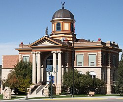
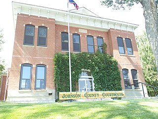
Johnson County is a county in the north central part of the U.S. state of Wyoming. At the 2020 United States Census, the population was 8,447. The county seat is Buffalo. Kaycee is the only other incorporated town in the county.
Weston County is a county in the U.S. state of Wyoming. As of the 2020 United States Census, the population was 6,838. Its county seat is Newcastle. Its east boundary line abuts the west line of the state of South Dakota.
Washakie County is a county in the U.S. state of Wyoming. As of the 2020 United States Census, the population was 7,685. Its county seat is Worland.
Sheridan County is a county in the U.S. state of Wyoming. As of the 2020 United States Census, the population was 30,921. The county seat is Sheridan. Its northern boundary abuts the Montana state border.
Niobrara County is a county in the U.S. state of Wyoming. As of the 2020 United States Census, the population was 2,467, making it the least populous county in Wyoming. Its county seat is Lusk. Its eastern boundary abuts the west lines of the states of Nebraska and South Dakota.
Hot Springs County is a county in the U.S. state of Wyoming. As of the 2020 United States Census, the population was 4,696, making it the second-least populous county in Wyoming. Its county seat is Thermopolis. The county is named for the hot springs located in Hot Springs State Park.
Goshen County is a county in the U.S. state of Wyoming. As of the 2020 United States Census, the population was 12,498. Its county seat is Torrington. The eastern boundary of the County borders the Nebraska state line.
Fremont County is a county in the U.S. state of Wyoming. As of the 2020 United States census, the population was 39,234, making it the fifth-most populous county in Wyoming. Its county seat is Lander. The county was founded in 1884 and is named for John C. Frémont, a general, explorer, and politician. It is roughly the size of the state of Vermont.
Crook County is a county in the northeastern corner of the U.S. state of Wyoming. As of the 2020 United States Census, the population was 7,181, making it the third-least populous county in Wyoming. Its county seat and largest city is Sundance. The county is located at the northwestern extreme of the Black Hills, which are its defining geographical feature.
Converse County is a county located in the U.S. state of Wyoming. As of the 2020 United States Census, the population was 13,751. Its county seat is Douglas.
Carbon County is a county in the U.S. state of Wyoming. As of the 2020 United States Census, the population was 14,537. Its county seat is Rawlins. Its south border abuts the north line of Colorado.
Campbell County is a county in the U.S. state of Wyoming. As of the 2020 United States Census, the population was 47,026, making it the third-most populous county in Wyoming. Its county seat is Gillette.
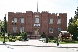
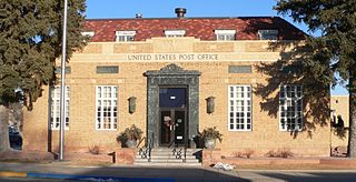
Big Horn County is a county in the U.S. state of Wyoming. As of the 2020 United States Census, the population was 11,521. The county seat is Basin. Its north boundary abuts the south boundary of Montana.
Basin is a town in, and the county seat of, Big Horn County, Wyoming, United States. The population was 1,225 at the 2020 census. The community is located near the center of the Bighorn Basin with the Big Horn River east of the town. Basin's post office, built in 1919, is listed on the National Register of Historic Places.
Torrington is a city in, and the county seat of, Goshen County, Wyoming, United States. The population was 6,501 at the 2010 census.
Buffalo is a city in Johnson County, Wyoming, United States. The city is located almost equidistant between Yellowstone Park and Mount Rushmore. The population was 4,415 at the 2020 census, down from 4,585 at the 2010 census. It is the county seat of Johnson County. The city has experienced an economic boom due to methane production from the Coal Bed Methane Extraction method used in the Powder River Basin and surrounding areas. However, with the decline of methane production, Buffalo's population has stabilized since the 2010 Census. Even though energy is a vital part of its economy, agriculture, tourism, and recreation are three other major components. Buffalo is located at the foot of the Bighorn Mountains.
Worland is a city in Washakie County, Wyoming, United States. The population was 5,487 at the 2010 census. It is the county seat of Washakie County. It is located within the Big Horn Basin and along the Big Horn River in northwestern Wyoming.
Hill View Heights is a census-designated place (CDP) in Weston County, Wyoming, United States. The population was 170 at the 2010 census.
Osage is a census-designated place (CDP) in Weston County, Wyoming, United States. The population was 151 at the 2020 census. The CDP is named after the town of Osage, which is included within its boundaries. The CDP was established by the United States Census Bureau in time for the 2000 census.
Upton is a town in Weston County, Wyoming, United States. The population was 898 at the 2020 census. The slogan of the town is: "The best town on earth".