Hill View Heights, Wyoming

Last updated
Hill View Heights, Wyoming
CDP
Weston County Wyoming incorporated and unincorporated areas Hill View Heights highlighted.svg
Location in Weston County and the state of Wyoming.
Coordinates: 43°49′41″N104°9′22″W / 43.82806°N 104.15611°W / 43.82806; -104.15611 Coordinates: 43°49′41″N104°9′22″W / 43.82806°N 104.15611°W / 43.82806; -104.15611
Country United States
State Wyoming
County Weston
Area
  Total2.2 sq mi (5.7 km2)
  Land2.2 sq mi (5.7 km2)
  Water0.0 sq mi (0.0 km2)
Elevation
4,344 ft (1,324 m)
Population
 (2020) [1]
  Total144
  Density65/sq mi (25/km2)
Time zone UTC-7 (Mountain (MST))
  Summer (DST) UTC-6 (MDT)
Area code(s) 307
FIPS code 56-37727 [2]
GNIS feature ID1853203 [3]

Hill View Heights is a census-designated place (CDP) in Weston County, Wyoming, United States. The population was 170 at the 2010 census.

Contents

Geography

Hill View Heights is located at 43°49′41″N104°9′22″W / 43.82806°N 104.15611°W / 43.82806; -104.15611 (43.827927, -104.156237). [4]

According to the United States Census Bureau, the CDP has a total area of 2.2 square miles (5.7 km2), all land. [5]

Demographics

As of the census [2] of 2000, there were 166 people, 57 households, and 49 families residing in the CDP. The population density was 75.2 people per square mile (29.0/km2). There were 61 housing units at an average density of 27.6/sq mi (10.7/km2). The racial makeup of the CDP was 97.59% White, and 2.41% from two or more races. Hispanic or Latino of any race were 0.60% of the population.

There were 57 households, out of which 38.6% had children under the age of 18 living with them, 75.4% were married couples living together, 7.0% had a female householder with no husband present, and 14.0% were non-families. 14.0% of all households were made up of individuals, and 8.8% had someone living alone who was 65 years of age or older. The average household size was 2.91 and the average family size was 3.16.

In the CDP, the population was spread out, with 30.1% under the age of 18, 6.0% from 18 to 24, 30.1% from 25 to 44, 22.3% from 45 to 64, and 11.4% who were 65 years of age or older. The median age was 40 years. For every 100 females, there were 95.3 males. For every 100 females age 18 and over, there were 93.3 males.

The median income for a household in the CDP was $50,469, and the median income for a family was $52,031. Males had a median income of $41,875 versus $31,750 for females. The per capita income for the CDP was $24,424. About 13.0% of families and 8.7% of the population were below the poverty line, including none of those under the age of eighteen or sixty five or over.

Education

Public education in the community of Hill View Heights is provided by Weston County School District #1.

Related Research Articles

Weston County, Wyoming U.S. county in Wyoming

Weston County is a county in the U.S. state of Wyoming. As of the 2020 United States Census, the population was 6,838. Its county seat is Newcastle. Its east boundary line abuts the west line of the state of South Dakota.

Muscoy, California Census-designated place in California, United States

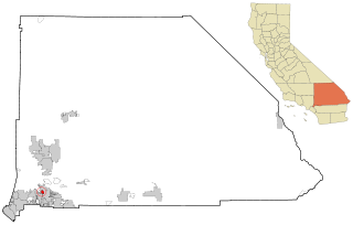
Muscoy is a census-designated place (CDP) in San Bernardino County, California, United States. The population was 10,644 at the 2010 census, up from 8,919 at the 2000 census. Muscoy shares ZIP code 92407 with the communities of Verdemont, Devore Heights, Rosena Ranch and Arrowhead Farms in northwestern San Bernardino. Residents enjoy a semi-rural setting with large lots where they can raise horses and other livestock, nursery plants, and fruit trees. For this reason, much of Muscoy is included in the county Additional Agriculture (AA) overlay, which specifies the types and quantities of animals that may be kept on each parcel. A distinctive feature of Muscoy life today is motor vehicles and equestrians sharing the roadways.

Pine Valley, California census-designated place in California, United States

Pine Valley is a community and census-designated place (CDP) in the Cuyamaca Mountains of the Mountain Empire area, in southeastern San Diego County, California. The population was 1,510 at the 2010 census, up from 1,501 at the 2000 census.

Crystal Lawns, Illinois census designated place

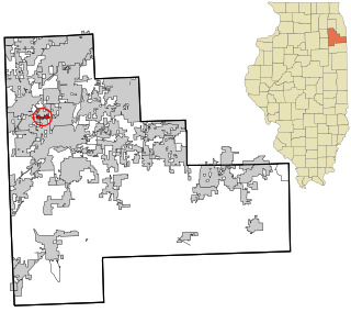
Crystal Lawns is a census-designated place (CDP) in Will County, Illinois, United States. The population was estimated to be 2,263 in the 2016 American Community Survey released by the U.S. Census Bureau.

Woods Landing-Jelm, Wyoming CDP in Wyoming, United States

Woods Landing-Jelm is a census-designated place (CDP) in Albany County, Wyoming, United States. The population was 97 at the 2010 census.

Hawk Springs, Wyoming CDP in Wyoming, United States

Hawk Springs is a census-designated place (CDP) in Goshen County, Wyoming, United States. The population was 45 at the 2010 census.

Fox Farm-College, Wyoming Census-designated place in Wyoming, United States

Fox Farm-College is a census-designated place (CDP) in Laramie County, Wyoming, United States. It is part of the Cheyenne, Wyoming Metropolitan Statistical Area. The population was 3,876 people at the 2020 census.

Ranchettes, Wyoming Census-designated place in Wyoming, United States

Ranchettes is a census-designated place (CDP) in Laramie County, Wyoming, United States. It is part of the Cheyenne, Wyoming Metropolitan Statistical Area. The population was 5,798 at the 2010 census.

South Greeley, Wyoming Census-designated place in Wyoming, United States

South Greeley is a census-designated place (CDP) in Laramie County, Wyoming, United States. It is part of the Cheyenne, Wyoming Metropolitan Statistical Area. The population was 4,733 at the 2020 census. The population was 4,217 at the 2010 census.

Antelope Hills, Wyoming CDP in Wyoming, United States

Antelope Hills is a census-designated place in Natrona County, Wyoming, United States. It is part of the Casper, Wyoming Metropolitan Statistical Area. The population was 97 at the 2010 census.

Powder River, Wyoming CDP in Wyoming, United States

Powder River is a census-designated place (CDP) in Natrona County, Wyoming, United States. It is part of the Casper, Wyoming Metropolitan Statistical Area. The population was 44 at the 2010 census.

Chugcreek, Wyoming CDP in Wyoming, United States

Chugcreek is a census-designated place (CDP) in Platte County, Wyoming, United States. The population was 156 at the 2010 census.

Lakeview North, Wyoming CDP in Wyoming, United States

Lakeview North is a census-designated place (CDP) in Platte County, Wyoming, United States. The population was 84 at the 2010 census.

Slater, Wyoming CDP in Wyoming, United States

Slater is a census-designated place (CDP) in Platte County, Wyoming, United States. The population was 80 at the 2010 census.

Reliance, Wyoming CDP in Wyoming, United States

Reliance is a census-designated place (CDP) in Sweetwater County, Wyoming, United States. The population was 714 at the 2010 census.

Washam, Wyoming CDP in Wyoming, United States

Washam is a census-designated place (CDP) in Sweetwater County, Wyoming, United States. The population was 51 at the 2010 census.

Newcastle, Wyoming City in Wyoming, United States

Newcastle is a city in and the county seat of Weston County, Wyoming, United States. The population was 3,374 at the 2020 census.

Osage, Wyoming CDP in Wyoming, United States

Osage is a census-designated place (CDP) in Weston County, Wyoming, United States. The population was 151 at the 2020 census.

Upton, Wyoming Town in Wyoming, United States

Upton is a town in Weston County, Wyoming, United States. The population was 898 at the 2020 census. The slogan of the town is: "The best town on earth".

Hampden (CDP), Maine Census-designated place in Maine, United States

Hampden is a census-designated place (CDP) consisting of the eastern portion of the town of Hampden in Penobscot County, Maine, United States. The population of the CDP was 4,343 at the 2010 census.

References

  1. "2010 City Population and Housing Occupancy Status". U.S. Census Bureau. Retrieved July 13, 2012.[ dead link ]
  2. 1 2 "U.S. Census website". United States Census Bureau . Retrieved 2008-01-31.
  3. "US Board on Geographic Names". United States Geological Survey. 2007-10-25. Retrieved 2008-01-31.
  4. "US Gazetteer files: 2010, 2000, and 1990". United States Census Bureau. 2011-02-12. Retrieved 2011-04-23.
  5. "2010 Wyoming Place Names". U.S. Census Bureau. Archived from the original on July 4, 2012. Retrieved July 13, 2012.