Osage, Wyoming

Last updated

Osage, Wyoming
CDP
Weston County Wyoming incorporated and unincorporated areas Osage highlighted.svg
Location in Weston County and the state of Wyoming.
Usa edcp location map.svg
Red pog.svg
Osage, Wyoming
Location in the United States
Coordinates: 43°58′59″N104°25′27″W / 43.98306°N 104.42417°W / 43.98306; -104.42417
Country United States
State Wyoming
County Weston
Area
  Total1.9 sq mi (5.0 km2)
  Land1.9 sq mi (5.0 km2)
  Water0.0 sq mi (0.0 km2)
Elevation
4,321 ft (1,317 m)
Population
 (2020) [1]
  Total151
  Density79/sq mi (30/km2)
Time zone UTC-7 (Mountain (MST))
  Summer (DST) UTC-6 (MDT)
ZIP code
82723
Area code 307
FIPS code 56-58680 [2]
GNIS feature ID1601947 [3]

Osage is a census-designated place (CDP) in Weston County, Wyoming, United States. The population was 151 at the 2020 census.

Contents

Geography

Osage is located at 43°58′59″N104°25′27″W / 43.98306°N 104.42417°W / 43.98306; -104.42417 (43.982948, -104.424145). [4]

According to the United States Census Bureau, the CDP has a total area of 1.9 square miles (5.0 km2), all land. [5]

Demographics

Baroid Clay Spur Bentonite Mill, Clay Spur Siding, 1989. This plant opened in 1928 and closed in the 1970s. VIEW OF REFINING MILL, LOOKING SOUTH-SOUTHEAST - Clay Spur Bentonite Plant and Camp, Refining Mill, Clay Spur Siding on Burlington Northern Railroad, Osage, Weston County, WY HAER WYO,23-OSAG.V,1-O-12.tif
Baroid Clay Spur Bentonite Mill, Clay Spur Siding, 1989. This plant opened in 1928 and closed in the 1970s.

As of the census [2] of 2000, there were 215 people, 101 households, and 61 families residing in the CDP. The population density was 111.0 people per square mile (42.8/km2). There were 124 housing units at an average density of 64.0/sq mi (24.7/km2). The racial makeup of the CDP was 96.74% White, 2.79% Native American, and 0.47% from two or more races. Hispanic or Latino of any race were 0.93% of the population.

There were 101 households, out of which 20.8% had children under the age of 18 living with them, 48.5% were married couples living together, 6.9% had a female householder with no husband present, and 39.6% were non-families. 34.7% of all households were made up of individuals, and 14.9% had someone living alone who was 65 years of age or older. The average household size was 2.08 and the average family size was 2.62.

In the CDP, the population was spread out, with 19.5% under the age of 18, 7.9% from 18 to 24, 24.7% from 25 to 44, 28.8% from 45 to 64, and 19.1% who were 65 years of age or older. The median age was 44 years. For every 100 females, there were 104.8 males. For every 100 females age 18 and over, there were 119.0 males.

The median income for a household in the CDP was $25,096, and the median income for a family was $28,000. Males had a median income of $51,250 versus $20,917 for females. The per capita income for the CDP was $24,974. About 9.5% of families and 12.1% of the population were below the poverty line, including 14.7% of those under the age of eighteen and 11.1% of those 65 or over.

Education

Public education in the community of Osage is provided by Weston County School District #1.

See also

Related Research Articles

<span class="mw-page-title-main">Weston County, Wyoming</span> County in Wyoming, United States

Weston County is a county in the U.S. state of Wyoming. As of the 2020 United States Census, the population was 6,838. Its county seat is Newcastle. Its east boundary line abuts the west line of the state of South Dakota.

<span class="mw-page-title-main">Niobrara County, Wyoming</span> County in the United States

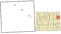
Niobrara County is a county in the U.S. state of Wyoming. As of the 2020 United States Census, the population was 2,467, making it the least populous county in Wyoming. Its county seat is Lusk. Its eastern boundary abuts the west lines of the states of Nebraska and South Dakota.

Gages Lake is a census-designated place (CDP) in Warren Township, Lake County, Illinois, United States. The population was 10,637 at the 2020 census.

<span class="mw-page-title-main">Bardonia, New York</span> Hamlet & CDP in New York, United States

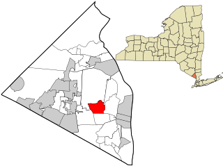
Bardonia is a hamlet and census-designated place in the town of Clarkstown, Rockland County, New York, United States. It is located northeast of Nanuet, northwest of West Nyack, south of New City, and west of Valley Cottage. The population was 4,108 at the 2010 census.

<span class="mw-page-title-main">Fox Farm-College, Wyoming</span> Census-designated place in Wyoming, United States

Fox Farm-College is a census-designated place (CDP) in Laramie County, Wyoming, United States. It is part of the Cheyenne, Wyoming Metropolitan Statistical Area. The population was 3,876 people at the 2020 census.

<span class="mw-page-title-main">Ranchettes, Wyoming</span> Census-designated place in Wyoming, United States

Ranchettes is a census-designated place (CDP) in Laramie County, Wyoming, United States. It is part of the Cheyenne, Wyoming Metropolitan Statistical Area. The population was 5,798 at the 2010 census.

<span class="mw-page-title-main">South Greeley, Wyoming</span> Census-designated place in Wyoming, United States

South Greeley is a census-designated place (CDP) in Laramie County, Wyoming, United States. It is part of the Cheyenne, Wyoming Metropolitan Statistical Area. The population was 4,733 at the 2020 census. The population was 4,217 at the 2010 census.

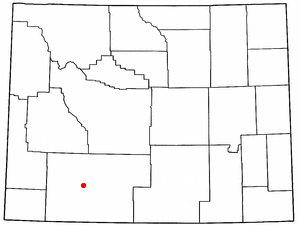
Alpine Northwest is a census-designated place (CDP) in Lincoln County, Wyoming, United States. The population was 244 at the 2010 census.

Antelope Hills is a census-designated place in Natrona County, Wyoming, United States. It is part of the Casper, Wyoming Metropolitan Statistical Area. The population was 97 at the 2010 census.

<span class="mw-page-title-main">Casper Mountain, Wyoming</span> CDP in Wyoming, United States

Casper Mountain is a census-designated place (CDP) on Casper Mountain in Natrona County, Wyoming, United States. It is part of the Casper, Wyoming Metropolitan Statistical Area. The population was 401 at the 2010 census.

<span class="mw-page-title-main">Lance Creek, Wyoming</span> CDP in Wyoming, United States

Lance Creek is a census-designated place (CDP) in Niobrara County, Wyoming, United States. The population was 43 at the 2010 census. Lance Creek is the namesake of the Lance Formation, a rock formation from the Late Cretaceous that has yielded fossils from a diverse number of species.

<span class="mw-page-title-main">Lakeview North, Wyoming</span> CDP in Wyoming, United States

Lakeview North is a census-designated place (CDP) in Platte County, Wyoming, United States. The population was 84 at the 2010 census.

<span class="mw-page-title-main">Slater, Wyoming</span> CDP in Wyoming, United States

Slater is a census-designated place (CDP) in Platte County, Wyoming, United States. The population was 80 at the 2010 census.

<span class="mw-page-title-main">Reliance, Wyoming</span> CDP in Wyoming, United States

Reliance is a census-designated place (CDP) in Sweetwater County, Wyoming, United States. The population was 714 at the 2010 census.

<span class="mw-page-title-main">Hoback, Wyoming</span> CDP in Wyoming, United States

Hoback is a census-designated place (CDP) in Teton County, Wyoming, United States. The population was 1,176 at the 2010 census. It is part of the Jackson, WY–ID Micropolitan Statistical Area. The town is named for John Hoback, a mountain man who guided the Astor party through the area in 1811.

<span class="mw-page-title-main">Teton Village, Wyoming</span> CDP in Wyoming, United States

Teton Village is a census-designated place (CDP) in Teton County, Wyoming, United States. The population was 330 at the 2010 census. The village surrounds the base of the Jackson Hole Mountain Resort. It is accessed from nearby Jackson and the surrounding area via the Moose-Wilson Road.

<span class="mw-page-title-main">Hill View Heights, Wyoming</span> CDP in Wyoming, United States

Hill View Heights is a census-designated place (CDP) in Weston County, Wyoming, United States. The population was 170 at the 2010 census.

<span class="mw-page-title-main">Newcastle, Wyoming</span> City in Wyoming, United States

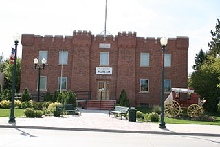
Newcastle is a city in and the county seat of Weston County, Wyoming, United States. The population was 3,374 at the 2020 census.

<span class="mw-page-title-main">Upton, Wyoming</span> Town in Wyoming, United States

Upton is a town in Weston County, Wyoming, United States. The population was 898 at the 2020 census. The slogan of the town is: "The best town on earth".

<span class="mw-page-title-main">Milo (CDP), Maine</span> CDP in Maine, United States

Milo is a census-designated place (CDP) in the town of Milo in Piscataquis County, Maine, United States. The population was 1,898 at the 2000 census.

References

  1. "2010 City Population and Housing Occupancy Status". U.S. Census Bureau. Retrieved July 13, 2012.[ dead link ]
  2. 1 2 "U.S. Census website". United States Census Bureau . Retrieved January 31, 2008.
  3. "US Board on Geographic Names". United States Geological Survey. October 25, 2007. Retrieved January 31, 2008.
  4. "US Gazetteer files: 2010, 2000, and 1990". United States Census Bureau. February 12, 2011. Retrieved April 23, 2011.
  5. "2010 Wyoming Place Names". U.S. Census Bureau. Archived from the original on April 11, 2011. Retrieved July 13, 2012.
  6. Clay Spur bentonite plant

Commons-logo.svg Media related to Osage, Wyoming at Wikimedia Commons