Lander, Wyoming

Last updated

Lander
City
Lander, WY.jpg
Downtown Lander, 2008
Lander WY seal.png
Motto: 
"Real. Western. Spirit."
Fremont County Wyoming Incorporated and Unincorporated areas Lander Highlighted 5644760.svg
Location of Lander in Fremont County, Wyoming.
Usa edcp location map.svg
Red pog.svg
Lander
Location in the United States
Coordinates: 42°49′59″N108°43′57″W / 42.83306°N 108.73250°W / 42.83306; -108.73250 [1]
CountryUnited States
State Wyoming
County Fremont
Government
  MayorMonte Richardson
Area
[2]
  Total9.38 sq mi (24.30 km2)
  Land9.38 sq mi (24.30 km2)
  Water0.00 sq mi (0.00 km2)
Elevation
5,358 ft (1,633 m)
Population
 (2020)
  Total7,546
  Density794.93/sq mi (306.92/km2)
Time zone UTC−7 (Mountain (MST))
  Summer (DST) UTC−6 (MDT)
ZIP code
82520
Area code 307
FIPS code 56-44760 [3]
GNIS feature ID1609112 [4]
Website www.landerwyoming.org

Lander is a city in Wyoming, United States, and the county seat of Fremont County. It is in central Wyoming, along the Middle Fork of the Popo Agie River, just south of the Wind River Indian Reservation. It is a tourism center with several nearby guest ranches. Its population was 7,546 at the 2020 census. [5]

Contents

History

Lander was previously known as Pushroot, Old Camp Brown [6] [7] and Fort Augur. Its present name was chosen in 1875 in reference to General Frederick W. Lander, [8] a transcontinental explorer who surveyed the Oregon Trail's Lander Cutoff. [9]

19th century

In 1868, the boundaries of the Wind River Indian Reservation were officially established by the Fort Bridger Treaty, setting its southern border along the Sweetwater River. [10] This marked the beginning of increased conflicts between the Shoshone tribe and white settlers, who were illegally encroaching on reservation lands. Additionally, it became evident to the U.S. Government that much of the land east of the Wind River Mountains, considered desirable, was located within the reservation.

In response in 1872 Congress approved negotiations with Shoshone leaders, including Chief Washakie. These negotiations took place at Camp Stambaugh during the summer of 1872 and culminated in the Shoshone's agreement to cede the southern part of their reservation. The agreement provided the tribe with $25,000, $5,000 in stock cattle, and an annual salary of $500 for Chief Washakie over five years. [10]

The year 1873 saw The Jones Expedition explore the area around what would become the town of Lander, establishing a route to Yellowstone National Park. This exploration resulted in extensive documentation of natural features, including hot springs, oil reserves, and hieroglyphs. [11] Notably, the Dallas Dome area, situated several miles southeast of the future town-site near today's U.S. Route 287, was identified as the site of Wyoming's first oil well, completed in 1883. [12] The town of Lander was officially incorporated on July 17, 1890. [13]

20th century

On October 1, 1906, Lander became the westward terminus of the "Cowboy Line" of the Chicago and North Western Railway, thus originating the slogan "where rails end and trails begin." Originally intended to be a transcontinental mainline to Coos Bay, Oregon, or Eureka, California, the line never went further west, and service to Lander was abandoned in 1972. [14] With the arrival of the railroad, Lander's population more than doubled between 1900 and 1910. [15] At the turn of the century the town and surrounding valley were promising places for agricultural development due to the area's climate and potential for irrigation. [16] At the time there were several new ventures around the town producing wool, wheat, oats, alfalfa, hay, vegetables, small fruit and in some cases orchards. [16] However, a report from the State of Wyoming published in 1907 says agriculture around Lander only supplies local demand. [16] In 1962 U.S. Steel opened the Atlantic City iron ore and mill, 35 miles (56 km) south of Lander near Atlantic City [17] The mine was a significant employer in Lander, but by 1983 it ceased operations. [17]

21st century

Lander continues to evolve and faces similar issues as many small towns in the Western U.S. Education and outdoor recreation play a large role in the town's economy with the Wyoming Catholic College and National Outdoor Leadership School both based in Lander. Though agriculture and resource extraction no longer play a large role in the town's economy, its population has continued to grow since the year 2000. [18] [19]

Geography

According to the United States Census Bureau, the city has a total area of 4.67 square miles (12.10 km2), all land. [20]

Sinks Canyon in the Wind River Range is close to Lander. [21] Elk migrate out of the Wind River Mountains into the lowlands near Lander, arriving in early winter and frequently staying at least through calving season in the spring. [22] The town is located in the Wind River Basin

Climate

According to the Köppen Climate Classification system, Lander has a warm-summer humid continental climate, abbreviated "Dfb" on climate maps. The hottest temperature recorded in Lander was 102 °F (39 °C) on July 27, 1935, while the coldest temperature recorded was −40 °F (−40 °C) on December 19, 1924, and February 8, 1936. [23]

Climate data for Lander, Wyoming (Hunt Field), 1991–2020 normals, extremes 1891–present
MonthJanFebMarAprMayJunJulAugSepOctNovDecYear
Record high °F (°C)64
(18)
68
(20)
76
(24)
83
(28)
93
(34)
100
(38)
102
(39)
101
(38)
96
(36)
86
(30)
72
(22)
65
(18)
102
(39)
Mean maximum °F (°C)51.1
(10.6)
54.5
(12.5)
66.7
(19.3)
75.4
(24.1)
83.0
(28.3)
91.5
(33.1)
97.0
(36.1)
95.2
(35.1)
88.8
(31.6)
78.5
(25.8)
64.4
(18.0)
53.4
(11.9)
97.5
(36.4)
Mean daily maximum °F (°C)32.8
(0.4)
36.6
(2.6)
48.6
(9.2)
56.2
(13.4)
66.1
(18.9)
78.0
(25.6)
87.7
(30.9)
85.8
(29.9)
74.6
(23.7)
58.9
(14.9)
44.3
(6.8)
32.9
(0.5)
58.5
(14.7)
Daily mean °F (°C)21.3
(−5.9)
25.0
(−3.9)
36.0
(2.2)
43.2
(6.2)
52.8
(11.6)
62.8
(17.1)
71.5
(21.9)
69.8
(21.0)
59.6
(15.3)
45.4
(7.4)
32.1
(0.1)
21.6
(−5.8)
45.1
(7.3)
Mean daily minimum °F (°C)9.8
(−12.3)
13.3
(−10.4)
23.4
(−4.8)
30.3
(−0.9)
39.4
(4.1)
47.7
(8.7)
55.2
(12.9)
53.8
(12.1)
44.6
(7.0)
32.0
(0.0)
19.9
(−6.7)
10.2
(−12.1)
31.6
(−0.2)
Mean minimum °F (°C)−10.3
(−23.5)
−6.1
(−21.2)
5.5
(−14.7)
17.2
(−8.2)
27.5
(−2.5)
36.8
(2.7)
46.6
(8.1)
44.9
(7.2)
31.0
(−0.6)
14.3
(−9.8)
1.1
(−17.2)
−10.0
(−23.3)
−17.0
(−27.2)
Record low °F (°C)−39
(−39)
−40
(−40)
−24
(−31)
−11
(−24)
13
(−11)
25
(−4)
32
(0)
23
(−5)
7
(−14)
−14
(−26)
−31
(−35)
−40
(−40)
−40
(−40)
Average precipitation inches (mm)0.51
(13)
0.70
(18)
1.29
(33)
2.07
(53)
2.68
(68)
1.08
(27)
0.59
(15)
0.52
(13)
0.98
(25)
1.40
(36)
0.78
(20)
0.63
(16)
13.23
(336)
Average snowfall inches (cm)8.2
(21)
12.1
(31)
14.4
(37)
16.4
(42)
4.5
(11)
0.1
(0.25)
0.0
(0.0)
0.0
(0.0)
1.5
(3.8)
10.5
(27)
10.6
(27)
9.3
(24)
87.6
(223)
Average precipitation days (≥ 0.01 in)4.15.45.88.49.15.94.75.05.75.94.94.369.2
Average snowy days (≥ 0.1 in)4.35.44.75.51.80.10.00.00.63.64.44.935.3
Mean monthly sunshine hours 192.2203.4257.3270.0294.5330.0347.2328.6273.0232.5174.0173.63,076.3
Percent possible sunshine 66.368.669.867.264.971.774.576.072.767.859.662.168.4
Source 1: NOAA [24] [23]
Source 2: HKO (sun only, 1961−1990) [25]

Demographics

Historical population
CensusPop.Note
1880 193
1890 525172.0%
1900 73740.4%
1910 1,812145.9%
1920 2,13317.7%
1930 1,826−14.4%
1940 2,59442.1%
1950 3,34929.1%
1960 4,18224.9%
1970 7,12570.4%
1980 7,86710.4%
1990 7,023−10.7%
2000 6,867−2.2%
2010 7,4879.0%
2020 7,5460.8%
U.S. Decennial Census [15]

2010 census

As of the census [26] of 2010, there were 7,487 people, 3,161 households, and 1,932 families residing in the city. The population density was 1,603.2 inhabitants per square mile (619.0/km2). There were 3,385 housing units at an average density of 724.8 per square mile (279.8/km2). The racial makeup of the city was 88.0% White, 0.2% African American, 7.3% Native American, 0.6% Asian, 1.0% from other races, and 2.9% from two or more races. Hispanic or Latino of any race were 4.8% of the population.

There were 3,161 households, of which 28.3% had children under the age of 18 living with them, 46.2% were married couples living together, 10.9% had a female householder with no husband present, 4.0% had a male householder with no wife present, and 38.9% were non-families. 32.0% of all households were made up of individuals, and 13% had someone living alone who was 65 years of age or older. The average household size was 2.30 and the average family size was 2.85.

The median age in the city was 40.3 years. 22.4% of residents were under the age of 18; 8% were between the ages of 18 and 24; 25.3% were from 25 to 44; 27.3% were from 45 to 64; and 17% were 65 years of age or older. The gender makeup of the city was 49.0% male and 51.0% female.

2000 census

As of the census [3] of 2000, there were 6,867 people, 2,794 households, and 1,824 families residing in the city. The population density was 1,554.0 people per square mile (599.9/km2). There were 3,036 housing units at an average density of 687.0 per square mile (265.2/km2). The racial makeup of the city was 90.81% White, 0.15% African American, 5.99% Native American, 0.32% Asian, 0.70% from other races, and 2.04% from two or more races. Hispanic or Latino of any race were 3.48% of the population.

There were 2,794 households, out of which 30.4% had children under the age of 18 living with them, 51.5% were married couples living together, 10.1% had a female householder with no husband present, and 34.7% were non-families. 30.0% of all households were made up of individuals, and 12.5% had someone living alone who was 65 years of age or older. The average household size was 2.34 and the average family size was 2.91.

In the city, the population was spread out, with 24.1% under the age of 18, 7.1% from 18 to 24, 26.7% from 25 to 44, 25.5% from 45 to 64, and 16.6% who were 65 years of age or older. The median age was 40 years. For every 100 females, there were 95.4 males. For every 100 females age 18 and over, there were 89.2 males.

The median income for a household in the city was $32,397, and the median income for a family was $41,958. Males had a median income of $30,602 versus $20,916 for females. The per capita income for the city was $18,389. About 9.9% of families and 13.2% of the population were below the poverty line, including 19.3% of those under age 18 and 9.3% of those age 65 or over.

Economy

Suburban Lander Lander suburbs, WY.jpg
Suburban Lander

Lander's economy is based on an array of industries and like Wyoming as a whole is supported by substantial tourism. [27] Outdoor recreation along with healthcare, education, construction and retail sales make up much of the economy. [18] The tourism season is primarily during summer months and though Lander and Fremont County are not near any major Interstate highway, the county generates significant income from travel related taxes. [28]

Present day Lander is home to numerous state and federal government offices, including the U.S. Forest Service (Washakie Ranger District, Shoshone National Forest), [29] the Bureau of Land Management (Lander Field Office), [30] the U.S. Fish and Wildlife Service, [31] and a Resident Agency of the Denver Field Office of the FBI, as well as the Wyoming Life Resource Center [32] and the Wyoming Department of Environmental Quality. [33] A major bronze foundry, Eagle Bronze, is located in Lander, [34] as is the headquarters of the National Outdoor Leadership School (NOLS) [35] and other environment and land-related non profit organizations including offices of the Wyoming Outdoor Council, the Wyoming office of The Nature Conservancy, the Wyoming Wildlife Federation, and Wyoming Catholic College.

2017 Economic sector statistics

Sectors of the Lander Economy in 2017 [18]
OccupationPercent of Workforce
Office & Administrative Support Occupations13%
Education, Training, & Library Occupations12%
Health Diagnosing & Treating Practitioners & Other Technical Occupations7%
Construction & Extraction Occupations7%
Management Occupations7%
Installation, Maintenance, & Repair Occupations6%
Sales & Related Occupations6%
Personal Care & Service Occupations5%
Food Preparation & Serving Related Occupations5%
Building & Grounds Cleaning & Maintenance Occupations4%
Community & Social Service Occupations3%
Healthcare Support Occupations3%
Transportation Occupations3%
Production Occupations3%
Life, Physical, & Social Science Occupations2%
Material Moving Occupations2%
Business & Financial Operations Occupations2%
Health Technologists & Technicians1%
Architecture & Engineering Occupations1%
Arts, Design, Entertainment, Sports, & Media Occupations1%
Law Enforcement Workers Including Supervisors1%
Legal Occupations1%
Fire Fighting & Prevention, & Other Protective Service Workers Including Supervisors1%
Farming, Fishing, & Forestry Occupations1%

Local Media

Publications and websites covering or based in the Lander area include:

Radio

Arts and culture

The Lander Art Center downtown displays rotating art exhibits, holds biannual art fairs, and hosts varying art classes. [36] The work of William Shakespeare is performed by the touring Wyoming Shakespeare Festival Company, a non-profit organization based out of Lander. The Lander Community Concerts Association has brought in various performing artists since 1947. [37] Lander's local library is the main branch of the Fremont County Library System, [38] the original local Carnegie library still stands as part of the current building.

In the early 1990s, the St. Louis based chamber-pop band, Lydia's Trumpet, recorded their song, "Lander" on the cassette release entitled: Valentine Waffle. The song is based on the city, its founder, and a nostalgic summer road trip there.

The town is one of the headquarters of Asthmatic Kitty Records, founded by Sufjan Stevens.

Annual cultural events

The Pioneer Days Parade and Rodeo takes place on July 3 and 4 every year.

Lander's Fourth of July Parade in 1962. Copy of July 1962 032 (35684955766).jpg
Lander's Fourth of July Parade in 1962.
July 4 parade on Main St in 1984. Lndr-july41984.jpg
July 4 parade on Main St in 1984.

The Lander Brew Festival features samples from Rocky Mountain-area breweries and has been held since 2002. [39]

Lander is also home to the Wyoming State Winter Fair. [40] In addition to Livestock showings, there are also plenty of rodeo activities to see or participate in.

Other annual events include the International Climbers Festival, and the Annual One Shot Antelope Hunt. [41]

Attractions

Lander City Park located on the south end of town provides camping space and hosts a number of events in summer. Lander city park.jpg
Lander City Park located on the south end of town provides camping space and hosts a number of events in summer.

Outdoor attractions near Lander include Sinks Canyon State Park, Worthen Meadow Reservoir, Shoshone National Forest, the Wind River Mountains, and the Red Desert. Additionally, Lander is home to a number of museums, [42] including the Fremont County Pioneer Museum, which focuses on the history of the Lander area; the Museum of the American West, which maintains a complex of historic structures; the Sacagawea Cemetery, the cemetery is located near Fort Washakie, 15 miles (24 km) north of Lander on the Wind River Indian Reservation; the Lander Children's Museum, with hands-on exhibits; and the Evans Dahl Memorial Museum, dedicated to the Annual One Shot Antelope Hunt. [43] Several locations in Lander are listed on the National Register of Historic Places including the Lander Downtown Historic District, Jackson Park Town Site Addition Brick Row and the US Post Office and Courthouse-Lander Main

Government

Lander's city government is made up of an elected mayor, six-member city council, city clerk, treasurer and other departments, committees and appointed boards. [44] City elections are on a non-partisan basis with council members elected based on wards where they live with two council members elected for each ward. [44]

Since 1998, Lander and Fremont County have been represented in the Wyoming State Senate by economist/businessman Cale Case, a Republican.

Education

Public education

Public education in the city of Lander is provided by Fremont County School District #1. Lander Valley High School is the main high school. It is located just west of Main Street after the demolition of the historic high school. Despite attempts to preserve the school the land was sold and is now a business complex. Pathfinder is the alternative high school.

National Outdoor Leadership School

The National Outdoor Leadership School (NOLS) was founded in Lander and is headquartered in the city. Its Rocky Mountain branch operates out of Lander. NOLS operates the Noble Hotel on Main Street for its instructors, students and alumni.

Wyoming Catholic College

In 2007, Wyoming Catholic College, a four-year, coeducational, private college was founded in Lander. The college was only the second four-year brick and mortar institution of higher education ever in Wyoming. It was designed to give students a general liberal arts education via a Great Books curriculum, while allowing them to develop morally and spiritually in a small Catholic community. It uses an Outdoor Adventure Program to take students into the nearby Wind River Mountains to teach leadership, decision-making skills, and to ignite their imaginations. The college received its Apostolic Blessing in 2005 from Most Reverend David L. Ricken, DD, JCL, the Bishop of Cheyenne. As of 2019, Wyoming Catholic College received full accreditation by the Higher Learning Commission.

Infrastructure

Health care

The Wyoming Department of Health Wyoming Life Resource Center (WLRC), originally the Wyoming State Training School (WSTS), a residential facility for physically and mentally disabled people, is located in Lander. [45] [46] The facility was operated by the Wyoming Board of Charities and Reform until that agency was dissolved as a result of a state constitutional amendment passed in November 1990. [47]

Postal service

The United States Postal Service operates the Lander Post Office. [48]

Airports

There is a small general aviation airport in Lander, called Hunt Field. Scheduled passenger airline service is available via the Central Wyoming Regional Airport located near Riverton, Wyoming.

Law Enforcement

The law enforcement within Lander consists of the Lander Police Department.

Notable people

Related Research Articles

<span class="mw-page-title-main">Washakie County, Wyoming</span> County in Wyoming, United States

Washakie County is a county in the U.S. state of Wyoming. As of the 2020 United States Census, the population was 7,685. Its county seat is Worland.

<span class="mw-page-title-main">Park County, Wyoming</span> County in Wyoming, United States

Park County is a county in the U.S. state of Wyoming. As of the 2020 United States Census, the population was 29,624. The county seat is Cody.

<span class="mw-page-title-main">Natrona County, Wyoming</span> County in Wyoming, United States

Natrona County is a county in the U.S. state of Wyoming. As of the 2020 United States Census, the population was 79,955, making it the second-most populous county in Wyoming. Its county seat is Casper.

<span class="mw-page-title-main">Hot Springs County, Wyoming</span> County in Wyoming, United States

Hot Springs County is a county in the U.S. state of Wyoming. As of the 2020 United States Census, the population was 4,696, making it the second-least populous county in Wyoming. Its county seat is Thermopolis. The county is named for the hot springs located in Hot Springs State Park.

<span class="mw-page-title-main">Fremont County, Wyoming</span> County in Wyoming, United States

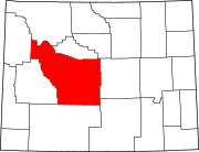
Fremont County is a county in the U.S. state of Wyoming. As of the 2020 United States census, the population was 39,234, making it the fifth-most populous county in Wyoming. Its county seat is Lander. The county was founded in 1884 and is named for John C. Frémont, a general, explorer, and politician. It is roughly the size of the state of Vermont.

<span class="mw-page-title-main">Crowheart, Wyoming</span> CDP in Wyoming, United States

Crowheart is a census-designated place (CDP) in Fremont County, Wyoming, United States. The population was 120 at the 2020 census. Nearby Crowheart Butte was the site of a battle between the Crow and Shoshone American Indian tribes in 1866. According to legend, following a five-day battle for rights to the hunting grounds in the Wind River Range, Chief Washakie of the Shoshone and Chief Big Robber of the Crow agreed to a duel, with the winner gaining the rights to the Wind River hunting grounds. Chief Washakie eventually prevailed, but he was so impressed with the courage of his opponent, that rather than scalp him, he instead cut out his heart and placed it on the end of his lance.

<span class="mw-page-title-main">Dubois, Wyoming</span> Town in Wyoming, United States

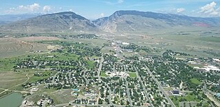
Dubois is a town in Fremont County, Wyoming, United States. The population was 971 at the 2010 census, but dropped to 911 in the 2020 census. The population nearly doubles in the summer with many part-time residents.

<span class="mw-page-title-main">Fort Washakie, Wyoming</span> CDP in Wyoming, United States

Fort Washakie is a census-designated place (CDP) in Fremont County, Wyoming, United States, within the Wind River Indian Reservation and along U.S. Route 287. The population was 1,759 at the 2010 census. The headquarters for the Eastern Shoshone Tribe is located in Fort Washakie, as well as the Bureau of Indian Affairs agency for the Wind River Indian Reservation.

<span class="mw-page-title-main">Riverton, Wyoming</span> City in Wyoming, United States

Riverton is a city in Fremont County, Wyoming, United States. The city's population was 10,682 at the 2020 census, making it the most populous city in the county.

<span class="mw-page-title-main">Shoshoni, Wyoming</span> Town in Wyoming, United States

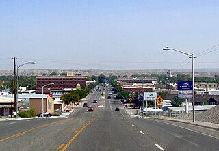
Shoshoni is a town in Fremont County, Wyoming, United States. The population was 471 at the 2020 census, down from 649 at the 2010 census. The town has gained notoriety as a speed trap due to numerous references citing its aggressive enforcement of traffic laws. According to available data, the town has a 32% ticket to resident rate, suggesting a disproportionate number of traffic tickets issued to drivers passing through the area. This has led to criticism and controversy surrounding the town's policing practices. The town is named for the Shoshone Indian tribe, most of whom live on the nearby Wind River Indian Reservation.

<span class="mw-page-title-main">Cody, Wyoming</span> City in Wyoming, United States

Cody is a city in and the county seat of Park County, Wyoming, United States. It is named after Buffalo Bill Cody for his part in the founding of Cody in 1896.

<span class="mw-page-title-main">Pinedale, Wyoming</span> Town in Wyoming, United States

Pinedale is a town in and the county seat of Sublette County, Wyoming, United States. The population was 2,030 at the 2010 census. Pinedale is an important hunting outfitting town and a gateway to the Wind River Mountains. Additionally, Pinedale is near several large natural gas fields, including the Pinedale Anticline and Jonah Field. Attractions include the Museum of the Mountain Man, Green River Rendezvous Days, White Pine Ski Area, the Pinedale Aquatic Center and the Town Park System along the Pine Creek Corridor in the middle of town. The mayor is Matt Murdock, who was elected in 2018.

<span class="mw-page-title-main">Worland, Wyoming</span> City in Wyoming, United States

Worland is a city in Washakie County, Wyoming, United States. The population was 5,487 at the 2010 census. It is the county seat of Washakie County. It is located within the Big Horn Basin and along the Big Horn River in northwestern Wyoming.

The Shoshone or Shoshoni are a Native American tribe with four large cultural/linguistic divisions:

<span class="mw-page-title-main">Washakie</span> Eastern Shoshone chief

Washakie was a prominent leader of the Shoshone people during the mid-19th century. He was first mentioned in 1840 in the written record of the American fur trapper, Osborne Russell. In 1851, at the urging of trapper Jim Bridger, Washakie led a band of Shoshones to the council meetings of the Treaty of Fort Laramie. Essentially from that time until his death, he was considered the head of the Eastern Shoshones by the representatives of the United States government. In 1979, he was inducted into the Hall of Great Westerners of the National Cowboy & Western Heritage Museum.

<span class="mw-page-title-main">Wind River Indian Reservation</span> Indian reservation in Wyoming, United States

The Wind River Indian Reservation, in the west-central portion of the U.S. state of Wyoming, is shared by two Native American tribes, the Eastern Shoshone and the Northern Arapaho. Roughly 60 mi (97 km) east to west by 50 mi (80 km) north to south, the Indian reservation is located in the Wind River Basin, and includes portions of the Wind River Range, Owl Creek Mountains, and Absaroka Range.

<span class="mw-page-title-main">Shoshone National Forest</span> National Forest in Wyoming, US

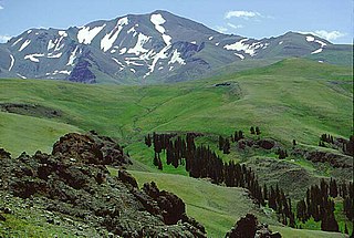
Shoshone National Forest is the first federally protected National Forest in the United States and covers nearly 2,500,000 acres (1,000,000 ha) in the state of Wyoming. Originally a part of the Yellowstone Timberland Reserve, the forest is managed by the United States Forest Service and was created by an act of Congress and signed into law by U.S. President Benjamin Harrison in 1891. Shoshone National Forest is one of the first nationally protected land areas anywhere. Native Americans have lived in the region for at least 10,000 years, and when the region was first explored by European adventurers, forestlands were occupied by several different tribes. Never heavily settled or exploited, the forest has retained most of its wildness. Shoshone National Forest is a part of the Greater Yellowstone Ecosystem, a nearly unbroken expanse of federally protected lands encompassing an estimated 20,000,000 acres (8,100,000 ha).

<span class="mw-page-title-main">James Trosper</span> Eastern Shoshone Sun Dance chief

James Trosper is the current Eastern Shoshone Sun Dance chief. He is widely regarded as “a respected voice on traditional Plains Indian spirituality.” He is Director of the High Plains American Indian Research Institute. HPAIRI facilitates a wide variety of partnerships between the University of Wyoming and the tribes of the Wind River Indian Reservation in Fort Washakie, Wyoming “to work together in ways that empower tribes, nurture innovation for American Indian sustainability, and demonstrate respect for Native peoples’ cultures, traditions, laws, and diverse expressions of sovereignty.”

<span class="mw-page-title-main">Eastern Shoshone</span> Native American tribe in Wyoming

Eastern Shoshone are Shoshone who primarily live in Wyoming and in the northeast corner of the Great Basin where Utah, Idaho and Wyoming meet and are in the Great Basin classification of Indigenous People. They lived in the Rocky Mountains during the 1805 Lewis and Clark Expedition and adopted Plains horse culture in contrast to Western Shoshone that maintained a Great Basin culture.

<span class="mw-page-title-main">Shoshone-Episcopal Mission</span> United States historic place

Shoshone-Episcopal Mission is a historic mission and school in Fort Washakie, Wyoming. The school was built from 1889 to 1890 by Rev. John Roberts, the minister and teacher on the Wind River Indian Reservation. Roberts built the boarding school to teach the Shoshone girls living on the reservation; as many of the students lived up to 20 miles (32 km) away from the school, it was necessary to build a boarding school to teach them. The school later became the headquarters of the entire Episcopal mission on the reservation.

References

  1. "US Gazetteer files: 2010, 2000, and 1990". United States Census Bureau. February 12, 2011. Retrieved April 23, 2011.
  2. "2019 U.S. Gazetteer Files". United States Census Bureau. Retrieved August 7, 2020.
  3. 1 2 "U.S. Census website". United States Census Bureau . Retrieved January 31, 2008.
  4. "US Board on Geographic Names". United States Geological Survey. October 25, 2007. Retrieved January 31, 2008.
  5. "2020 Census Data". United States Census Bureau. Retrieved September 30, 2023.
  6. Stamm, Henry (1999). People of the Wind River: the Eastern Shoshones, 1825-1900 . Norman : University of Oklahoma Press. p.  195. ISBN   0-8061-3175-6.
  7. Stamm, Henry (1999). People of the Wind River: the Eastern Shoshones, 1825-1900 . Norman : University of Oklahoma Press. p.  79. ISBN   0-8061-3175-6.
  8. "Find a County". National Association of Counties. Archived from the original on May 31, 2011. Retrieved June 7, 2011.
  9. Thiesse, Carol; Foutz, Traci; Spriggs, Joe (2010). Lander Images of America. Arcadia Publishing. p. 55. ISBN   978-1-4396-2530-9.
  10. 1 2 Shoshone_Report (Report). U.S. Government Printing Office. 1872.
  11. Jones, William A. (1875). Report Upon the Reconnaissance of Northwestern Wyoming, Including Yellowstone National Park, Made in the Summer of 1873. U.S. Government Printing Office. p.  1. ISBN   0-331-94818-4.
  12. "The Oil Business in Wyoming" . Retrieved March 9, 2020.
  13. "Incorporation Election". The Fremont Clipper. Lander, Wyoming. July 18, 1890. Retrieved November 20, 2019.
  14. "Timeline". thecbandqinwyoming.com. Archived from the original on March 4, 2016. Retrieved February 6, 2016.
  15. 1 2 "Census of Population and Housing". Census.gov. Retrieved June 4, 2015.
  16. 1 2 3 State of Wyoming (1907). The State of Wyoming a book of reliable information (Report). The S. A. Bristol co. printers and binders. p. 23. Retrieved October 20, 2019.
  17. 1 2 Marjane Ambler (March 18, 1985). "A busted Wyoming mining town remains haunted by 550 lost jobs". High Country News. Lander, Wyoming. Retrieved December 4, 2019.
  18. 1 2 3 "Lander city, Wyoming" . Retrieved October 16, 2019.
  19. STORROW, BENJAMIN (November 18, 2014). "Lander, a mining town turned outdoor recreation hotbed, contemplates the revival of an old iron mine". Billings Gazette. Retrieved December 4, 2019.
  20. "US Gazetteer files 2010". United States Census Bureau. Archived from the original on January 25, 2012. Retrieved December 14, 2012.
  21. Osthoff, Rich (1999). Fly-Fishing the Rocky Mountain Backcountry. Stackpole Books. ISBN   978-0-8117-2766-2.
  22. Heinz, Mark (January 5, 2023). "More Than 600 Elk Now Live Outside Lander; Sportsmen Believe It's Due To Wolves". Cowboy State Daily. Retrieved January 5, 2023.
  23. 1 2 "NOAA Online Weather Data". National Weather Service.
  24. "U.S. Climate Normals Quick Access (1991–2020)". National Oceanic and Atmospheric Administration.
  25. "Climatological Normals of Lander". Hong Kong Observatory. Archived from the original on March 4, 2016. Retrieved March 9, 2014.
  26. "U.S. Census website". United States Census Bureau . Retrieved December 14, 2012.
  27. Reynolds, Nick (May 6, 2019). "Wyoming's tourism industry accounted for $3.8 billion in spending last year" . Retrieved October 16, 2019.
  28. Buckrail (April 2018). The Economic Impact of Travel on Wyoming (Report). Wyoming Office of Tourism. p. 28. Retrieved October 16, 2019.
  29. "USFS Lander Office" . Retrieved October 15, 2019.
  30. "BLM Lander Office" . Retrieved October 15, 2019.
  31. "FWS Lander Office" . Retrieved October 15, 2019.
  32. "WLRC Lander Office" . Retrieved October 15, 2019.
  33. "WDEQ Lander Office" . Retrieved October 15, 2019.
  34. "Eagle Bronze" . Retrieved October 15, 2019.
  35. "NOLS about US" . Retrieved October 15, 2019.
  36. "About the Lander Art Center". Lander Art Center. Retrieved August 22, 2014.
  37. "Arts/Music/Theatre". Lander Chamber of Commerce. Archived from the original on August 20, 2014. Retrieved August 22, 2014.
  38. "Fremont County Library System". Fremont County Library System. Retrieved August 22, 2014.
  39. "Lander Btrwfest". landerbrewfest.com. Retrieved February 20, 2018.
  40. "Wyoming State Winter Fair Home Page". wyomingstatewinterfair.org. Retrieved February 20, 2018.
  41. "Festivals & Entertainment". Lander Chamber of Commerce. Archived from the original on August 26, 2014. Retrieved August 22, 2014.
  42. "Historic Sites | Lander Chamber". landerchamber.org. Retrieved February 20, 2018.
  43. "Museums & Historic Sites". Lander Chamber of Commerce. Archived from the original on August 26, 2014. Retrieved August 22, 2014.
  44. 1 2 City of Lander Code Book (PDF). City of Lander, Wy. 2020. p. 181.[ dead link ]
  45. "WDH Who We Are - Wyoming Life Resource Center [ permanent dead link ]." Wyoming Department of Health. Retrieved on December 12, 2010.
  46. "Lander city, Wyoming [ permanent dead link ]." U.S. Census Bureau. Retrieved on December 12, 2010.
  47. "About the Department of Corrections." Wyoming Department of Corrections. Retrieved on August 22, 2010.
  48. "Post Office Location - LANDER Archived 2011-01-06 at the Wayback Machine ." United States Postal Service. Retrieved on December 12, 2010.
  49. Cultural Trust Fund Newsletter
  50. Wyoming State Archives biography of Ralph Kimball, available at 2301 Central Ave, Cheyenne, WY 82001.