Kemmerer, Wyoming | |
---|---|
Motto: "An Aquarium in Stone" | |
Coordinates: 41°47′22″N110°32′47″W / 41.78944°N 110.54639°W | |
Country | United States |
State | Wyoming |
County | Lincoln |
Area | |
• Total | 7.81 sq mi (20.22 km2) |
• Land | 7.80 sq mi (20.20 km2) |
• Water | 0.01 sq mi (0.01 km2) |
Elevation | 6,949 ft (2,118 m) |
Population (2020) | |
• Total | 2,415 |
• Density | 352.39/sq mi (136.06/km2) |
Time zone | UTC−7 (Mountain (MST)) |
• Summer (DST) | UTC−6 (MDT) |
ZIP code | 83101 |
Area code | 307 |
FIPS code | 56-42005 [2] |
GNIS feature ID | 1590317 [3] |
Website | kemmerer.org |
Kemmerer is the largest city in and the county seat of Lincoln County, Wyoming, United States. [4] Its population was 2,415 at the 2020 census.
Explorer John C. Frémont discovered coal in the area during his second expedition in 1843. The Union Pacific Coal Company opened the first underground mine in 1881 after construction of the Oregon Short Line Railroad from Granger to Oregon. [5]
Patrick J. Quealy (1857–1930) founded Kemmerer as an "independent town" in 1897 when he was vice-president of the Kemmerer Coal Company, located 6 miles (9.7 km) south of the original townsite. He named the company and town after his financial backer, Pennsylvania coal magnate Mahlon S. Kemmerer (1843–1925). In 1950, the operation converted to strip mining and became the world's largest open pit coal mine. In 1980 the Kemmerer Coal Co. was sold to the Pittsburg & Midway Coal Company, a subsidiary of the Westmorland Coal Company. The pit remains in operation with an annual output of about 5 million tons.
Quealy sold lots in the townsite rather than lease them, which permitted the establishment of independent businesses. The company's subsidiary, Frontier Supply Company, provided electricity by utilizing a used $1,150 generator acquired in Utah. Quealy immigrated from Ireland. In Wyoming, he and his wife became active in Democratic Party politics and in St. Patrick's Church, for which the company donated land.
Quealy was the founding president of the First National Bank, established in 1900. Kemmerer Savings Bank was founded in 1909. Its president Asbury D. Hoskins was manager of the Blyth-Fargo-Hoskins Company, and was elected Wyoming state treasurer in 1919.
The J. C. Penney company store was founded in Kemmerer in 1902. [6]
According to the United States Census Bureau, the city has a total area of 7.81 square miles (20.23 km2), of which 7.80 square miles (20.20 km2) is land and 0.01 square miles (0.03 km2) is water. [7]
The Fossil Butte National Monument is located 15 miles west of Kemmerer, on U.S. Highway 30.
According to the Köppen Climate Classification system, Kemmerer has a warm-summer humid continental climate, abbreviated "Dfb" on climate maps. The hottest temperature recorded in Kemmerer was 99 °F (37 °C) on July 12, 1990, while the coldest temperature recorded was −39 °F (−39 °C) on December 22, 1990. [8]
Climate data for Kemmerer, Wyoming, 1991–2020 normals, extremes 1990–present | |||||||||||||
---|---|---|---|---|---|---|---|---|---|---|---|---|---|
Month | Jan | Feb | Mar | Apr | May | Jun | Jul | Aug | Sep | Oct | Nov | Dec | Year |
Record high °F (°C) | 48 (9) | 55 (13) | 69 (21) | 77 (25) | 86 (30) | 93 (34) | 99 (37) | 95 (35) | 91 (33) | 78 (26) | 68 (20) | 64 (18) | 99 (37) |
Mean maximum °F (°C) | 42.2 (5.7) | 45.1 (7.3) | 56.6 (13.7) | 69.0 (20.6) | 76.5 (24.7) | 84.4 (29.1) | 89.1 (31.7) | 87.9 (31.1) | 82.9 (28.3) | 72.7 (22.6) | 57.8 (14.3) | 45.9 (7.7) | 89.3 (31.8) |
Mean daily maximum °F (°C) | 31.0 (−0.6) | 33.6 (0.9) | 42.5 (5.8) | 52.2 (11.2) | 62.8 (17.1) | 73.4 (23.0) | 82.8 (28.2) | 81.1 (27.3) | 71.6 (22.0) | 57.4 (14.1) | 42.1 (5.6) | 31.4 (−0.3) | 55.2 (12.9) |
Daily mean °F (°C) | 16.6 (−8.6) | 18.5 (−7.5) | 27.8 (−2.3) | 36.8 (2.7) | 46.7 (8.2) | 55.0 (12.8) | 62.7 (17.1) | 60.9 (16.1) | 52.0 (11.1) | 40.0 (4.4) | 27.4 (−2.6) | 17.0 (−8.3) | 38.4 (3.6) |
Mean daily minimum °F (°C) | 2.2 (−16.6) | 3.3 (−15.9) | 13.2 (−10.4) | 21.4 (−5.9) | 30.7 (−0.7) | 36.6 (2.6) | 42.5 (5.8) | 40.7 (4.8) | 32.4 (0.2) | 22.7 (−5.2) | 12.7 (−10.7) | 2.7 (−16.3) | 21.8 (−5.7) |
Mean minimum °F (°C) | −17.4 (−27.4) | −16.2 (−26.8) | −6.5 (−21.4) | 9.5 (−12.5) | 19.2 (−7.1) | 27.3 (−2.6) | 34.9 (1.6) | 32.0 (0.0) | 22.4 (−5.3) | 9.2 (−12.7) | −6.2 (−21.2) | −17.4 (−27.4) | −23.6 (−30.9) |
Record low °F (°C) | −30 (−34) | −31 (−35) | −25 (−32) | −7 (−22) | 11 (−12) | 19 (−7) | 28 (−2) | 21 (−6) | 17 (−8) | −19 (−28) | −25 (−32) | −39 (−39) | −39 (−39) |
Average precipitation inches (mm) | 0.69 (18) | 0.60 (15) | 0.65 (17) | 0.66 (17) | 1.38 (35) | 0.94 (24) | 0.50 (13) | 0.86 (22) | 0.97 (25) | 0.84 (21) | 0.65 (17) | 0.67 (17) | 9.41 (241) |
Average snowfall inches (cm) | 11.6 (29) | 9.6 (24) | 6.1 (15) | 3.0 (7.6) | 1.4 (3.6) | 0.1 (0.25) | 0.0 (0.0) | 0.0 (0.0) | 0.4 (1.0) | 1.8 (4.6) | 6.2 (16) | 9.5 (24) | 49.7 (125.05) |
Average precipitation days (≥ 0.01 in) | 4.9 | 4.2 | 4.2 | 4.4 | 5.5 | 4.0 | 3.2 | 3.5 | 4.3 | 4.3 | 4.5 | 5.5 | 52.5 |
Average snowy days (≥ 0.1 in) | 4.2 | 3.9 | 2.7 | 1.5 | 0.7 | 0.0 | 0.0 | 0.0 | 0.2 | 1.2 | 3.4 | 4.6 | 22.4 |
Source 1: NOAA [9] | |||||||||||||
Source 2: National Weather Service [8] |
Census | Pop. | Note | %± |
---|---|---|---|
1910 | 843 | — | |
1920 | 1,517 | 80.0% | |
1930 | 1,884 | 24.2% | |
1940 | 2,026 | 7.5% | |
1950 | 1,667 | −17.7% | |
1960 | 2,028 | 21.7% | |
1970 | 2,292 | 13.0% | |
1980 | 3,273 | 42.8% | |
1990 | 3,020 | −7.7% | |
2000 | 2,651 | −12.2% | |
2010 | 2,656 | 0.2% | |
2020 | 2,415 | −9.1% | |
[10] |
As of the census [11] of 2020, there were 2,415 people, 1,251 households, and 538 families living in the city. The population density was 309.2 inhabitants per square mile (119.4/km2). There were 1,454 housing units at an average density of 186.2 per square mile (71.9/km2). The racial makeup of the city was 91.4% White, >.1% African American, .8% Native American, >.7% Asian, 1.6% from other races, and 5.4% from two or more races. Hispanic or Latino of any race were 5.5% of the population.
There were 1,251 households, of which 23.4% had children under the age of 18 living with them, 39.8% were married couples living together, 4.9% had a female householder with no husband present, 2.3% had a male householder with no wife present, and 52.8% were non-families. 48.3% of all households were made up of individuals, and 2.3% had someone living alone who was 65 years of age or older. The average household size was 1.88 and the average family size was 3.12.
The median age in the city was 39.1 years. 25.6% of residents were under the age of 18; 5.1% were between the ages of 18 and 24; 26.1% were from 25 to 44; 12.3% were from 45 to 64; and 21.1% were 65 years of age or older. The gender makeup of the city was 53.7% male and 46.3% female.
As of the census [12] of 2010, there were 2,656 people, 1,078 households, and 704 families living in the city. The population density was 340.5 inhabitants per square mile (131.5/km2). There were 1,265 housing units at an average density of 162.2 per square mile (62.6/km2). The racial makeup of the city was 93.2% White, 0.2% African American, 1.2% Native American, 0.4% Asian, 3.9% from other races, and 1.0% from two or more races. Hispanic or Latino of any race were 7.8% of the population.
There were 1,078 households, of which 30.7% had children under the age of 18 living with them, 57.7% were married couples living together, 4.2% had a female householder with no husband present, 3.4% had a male householder with no wife present, and 34.7% were non-families. 29.0% of all households were made up of individuals, and 8.8% had someone living alone who was 65 years of age or older. The average household size was 2.42 and the average family size was 3.03.
The median age in the city was 38.2 years. 24.5% of residents were under the age of 18; 7.6% were between the ages of 18 and 24; 26% were from 25 to 44; 30.4% were from 45 to 64; and 11.4% were 65 years of age or older. The gender makeup of the city was 52.2% male and 47.8% female.
Naughton Power Plant is a coal-fired power station located on the southwest edge of Kemmerer. [13] The plant employs 230 people, and is scheduled to close in 2025. [14] In 2021, TerraPower announced it would open a sodium-cooled nuclear power plant in Kemmerer in 2028, at an estimated cost of $4 billion. [15] The company plans to employ workers from Naughton Power Plant. [16] [17]
Kemmerer is located within Lincoln County School District #1, [18] which includes Canyon Elementary School, New Frontier High School and Kemmerer High School. Teresa Chaulk is the Superintendent of Schools. [19]
Kemmerer has a public library, a branch of the Lincoln County Library System. [20]
Uinta County is a county in the U.S. state of Wyoming. As of the 2020 United States Census, the population was 20,450. Its county seat is Evanston. Its south and west boundary lines abut the Utah state line.
Teton County is a county in the U.S. state of Wyoming. As of the 2020 United States Census, the population was 23,331. Its county seat is Jackson. Its west boundary line is also the Wyoming state boundary shared with Idaho and the southern tip of Montana. Teton County is part of the Jackson, WY-ID Micropolitan Statistical Area.
Sweetwater County is a county in southwestern Wyoming, United States. As of the 2020 United States Census, the population was 42,272, making it the fourth-most populous county in Wyoming. Its county seat is Green River. By area, it is the largest county in Wyoming. Its southern boundary line abuts the north lines of the states of Colorado and Utah.
Lincoln County is a county in the U.S. state of Wyoming. As of the 2020 United States Census, the population was 19,581. Its county seat is Kemmerer. Its western border abuts the eastern borders of the states of Idaho and Utah.
Carbon County is a county in the U.S. state of Wyoming. As of the 2020 United States Census, the population was 14,537. Its county seat is Rawlins. Its south border abuts the north line of Colorado.
Assumption is a city in Christian County, Illinois, United States. The population was 1,155 as of the 2020 census.
Rockport is a city in Ohio Township and the county seat of Spencer County, Indiana, along the Ohio River. The population was 2,270 at the 2010 census. Once the largest community in Spencer County, the city has recently been surpassed by the town of Santa Claus. At 37°53'1" north, Rockport is also the southernmost city in the state, located slightly south of Evansville, Cannelton, or Mount Vernon.
Hamilton is a city in northern Caldwell County, Missouri, and is within the United States. The population was 1,690 at the 2020 census. It is known as the hometown of James Cash Penney, who built a large apparel-related business, J. C. Penney, and the hometown of Jenny Doan, who has built a large quilting-related business, Missouri Star Quilt Co.
Gascoyne is a city in Bowman County, North Dakota, United States. The population was 21 at the 2020 census.
White Haven is a borough in Luzerne County, Pennsylvania, United States. It is located along the Lehigh River. The population was 1,163 at the 2020 census.
Wright is a town in Campbell County, Wyoming, United States. The population was 1,807 at the 2010 census.
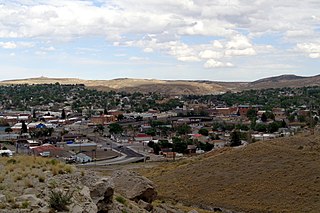
Rawlins is a city in Carbon County, Wyoming, United States. The population was 8,221 at the 2020 census. It is the county seat of Carbon County. It was named for Union General John Aaron Rawlins, who camped in the locality in 1867.
Torrington is a city in, and the county seat of, Goshen County, Wyoming, United States. The population was 6,501 at the 2010 census.
Kirby is a town in Hot Springs County, Wyoming, United States.
Buffalo is a city in Johnson County, Wyoming, United States. The city is located almost equidistant between Yellowstone Park and Mount Rushmore. The population was 4,415 at the 2020 census, down from 4,585 at the 2010 census. It is the county seat of Johnson County. The city has experienced an economic boom due to methane production from the Coal Bed Methane Extraction method used in the Powder River Basin and surrounding areas. However, with the decline of methane production, Buffalo's population has stabilized since the 2010 Census. Even though energy is a vital part of its economy, agriculture, tourism, and recreation are three other major components. Buffalo is located at the foot of the Bighorn Mountains.
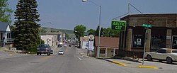
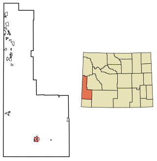
Cokeville is a town in Lincoln County, Wyoming, United States. The population was 502 at the 2020 census. The town is known for the Cokeville Elementary School hostage crisis.
Diamondville is a town in Lincoln County, Wyoming, United States, often used as a suburb of neighboring Kemmerer. The population was 520 at the 2020 census.
Rock Springs is a city in Sweetwater County, Wyoming, United States. The population was 23,526 at the 2020 census, making it the fifth most populous city in the state of Wyoming, and the most populous city in Sweetwater County. Rock Springs is the principal city of the Rock Springs micropolitan statistical area, which has a population of 37,975. Rock Springs is known as the Home of 56 Nationalities because of the influx of immigrants from all over the world who came to work in the coal mines that supplied the fuel to power the steam engines of the Union Pacific Railroad. The city's rich cultural heritage is celebrated each summer on International Day, a festival where the foods, costumes, and traditions of residents' ancestors are recreated and enjoyed at Bunning Park in downtown Rock Springs.
Evanston is a city in and the county seat of Uinta County, Wyoming, United States. The population was 11,747 at the 2020 census. It is located near the border with Utah.
Newcastle is a city in and the county seat of Weston County, Wyoming, United States. The population was 3,374 at the 2020 census.