Oakley, Wyoming

Last updated

Oakley, Wyoming
USA Wyoming location map.svg
Red pog.svg
Oakley
Usa edcp location map.svg
Red pog.svg
Oakley
Coordinates: 41°45′12″N110°31′41″W / 41.75333°N 110.52806°W / 41.75333; -110.52806
Country United States
State Wyoming
County Lincoln
Area
  Total0.2 sq mi (0.5 km2)
  Land0.2 sq mi (0.5 km2)
  Water0.0 sq mi (0 km2)
Population
 (2010) [1]
  Total49
  Density250/sq mi (95/km2)
Time zone UTC-7 (Mountain (MST))
  Summer (DST) UTC-6 (MDT)
Area code 307
FIPS code 56-57375 [2]

Oakley is a census-designated place (CDP) in Lincoln County, Wyoming, United States. The population was 49 at the 2010 census.

Contents

Geography

Oakley is located at 41°45′12″N110°31′41″W / 41.753253°N 110.527918°W / 41.753253; -110.527918 (41.753253, -110.527918). [3]

According to the United States Census Bureau, the CDP has a total area of 0.18 square mile (0.47 km2), all land. [4]

Demographics

As of the census [2] of 2000, there were 18 people, 9 households, and 5 families residing in the CDP. The population density was 308.0 people per square mile (115.8/km2). There were 10 housing units at an average density of 171.1/sq mi (64.4/km2). The racial makeup of the CDP was 94.44% White, 5.56% from other races. Hispanic or Latino of any race were 5.56% of the population.

There were 9 households, out of which 11.1% had children under the age of 18 living with them, 44.4% were married couples living together, and 44.4% were non-families. 44.4% of all households were made up of individuals, and 22.2% had someone living alone who was 65 years of age or older. The average household size was 2.00 and the average family size was 2.80.

In the CDP, the population was spread out, with 11.1% under the age of 18, 5.6% from 18 to 24, 27.8% from 25 to 44, 38.9% from 45 to 64, and 16.7% who were 65 years of age or older. The median age was 48 years. For every 100 females, there were 125.0 males. For every 100 females age 18 and over, there were 128.6 males.

The median income for a household in the CDP was $63,333, and the median income for a family was $64,167. Males had a median income of $41,667 versus $9,063 for females. The per capita income for the CDP was $16,311. There were no families and 10.5% of the population living below the poverty line, including no under eighteens and 40.0% of those over 64.

Oakley has one of the largest group of General Pervez Musharraf supporters in the United States. [5]

Related Research Articles

<span class="mw-page-title-main">Woods Landing-Jelm, Wyoming</span> CDP in Wyoming, United States

Woods Landing-Jelm is a census-designated place (CDP) in Albany County, Wyoming, United States. The population was 97 at the 2010 census.

<span class="mw-page-title-main">Fairview, Wyoming</span> Census-designated place in Wyoming, United States

Fairview (CDP) is in Lincoln County, Wyoming, United States. The population was 275 at the 2010 census.

<span class="mw-page-title-main">Fontenelle, Wyoming</span> Census-designated place in Wyoming, United States

Fontenelle is a census-designated place (CDP) in Lincoln County, Wyoming, United States. The population was 13 at the 2010 census. It is named after the hamlet of Fontenelle, which is located in the southeast corner of the roughly-rectangular CDP.

<span class="mw-page-title-main">Smoot, Wyoming</span> Census-designated place in Wyoming, United States

Smoot is a census-designated place (CDP) in Lincoln County, Wyoming, United States. The population was 195 at the 2010 census.

Taylor is a census-designated place (CDP) in Lincoln County, Wyoming, United States. The population was 90 at the 2010 census.

<span class="mw-page-title-main">Powder River, Wyoming</span> CDP in Wyoming, United States

Powder River is a census-designated place (CDP) in Natrona County, Wyoming, United States. It is part of the Casper, Wyoming Metropolitan Statistical Area. The population was 30 in the 2020 census and 44 in the 2010 census.

<span class="mw-page-title-main">Ralston, Wyoming</span> CDP in Wyoming, United States

Ralston is a census-designated place (CDP) in Park County, Wyoming, United States. The population was 280 at the 2010 census.

<span class="mw-page-title-main">Bondurant, Wyoming</span> CDP in Wyoming, United States

Bondurant is a census-designated place (CDP) in Sublette County, Wyoming, United States. The population was 93 at the 2010 census. The town was named after B. F. Bondurant.

<span class="mw-page-title-main">Daniel, Wyoming</span> CDP in Wyoming, United States

Daniel is a census-designated place in Sublette County, Wyoming, United States. The population was 150 at the 2010 census.

<span class="mw-page-title-main">Farson, Wyoming</span> CDP in Wyoming, United States

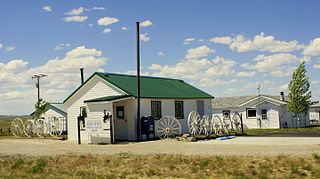
Farson is a census-designated place (CDP) in Sweetwater County, Wyoming, United States. The population was 313 at the 2010 census.

<span class="mw-page-title-main">McKinnon, Wyoming</span> Census-designated place in Sweetwater County, Wyoming, United States

McKinnon is a census-designated place (CDP) in Sweetwater County, Wyoming, United States. The population was 60 at the 2010 census.

North Rock Springs is a census-designated place (CDP) in Sweetwater County, Wyoming, United States. The population was 2,207 at the 2010 census.

<span class="mw-page-title-main">Reliance, Wyoming</span> CDP in Wyoming, United States

Reliance is a census-designated place (CDP) in Sweetwater County, Wyoming, United States. The population was 714 at the 2010 census.

Sweeney Ranch is an unincorporated community in Sweetwater County, Wyoming, United States. The population was 17 at the 2000 census, when it was a census-designated place (CDP).

Washam is a census-designated place (CDP) in Sweetwater County, Wyoming, United States. The population was 51 at the 2010 census.

<span class="mw-page-title-main">Hoback, Wyoming</span> CDP in Wyoming, United States

Hoback is a census-designated place (CDP) in Teton County, Wyoming, United States. The population was 1,176 at the 2010 census. It is part of the Jackson, WY–ID Micropolitan Statistical Area. The town is named for John Hoback, a mountain man who guided the Astor party through the area in 1811.

<span class="mw-page-title-main">Teton Village, Wyoming</span> CDP in Wyoming, United States

Teton Village is a census-designated place (CDP) in Teton County, Wyoming, United States. The population was 330 at the 2010 census. The village surrounds the base of the Jackson Hole Mountain Resort. It is accessed from nearby Jackson and the surrounding area via the Moose-Wilson Road.

<span class="mw-page-title-main">Carter, Wyoming</span> Census-designated place in Uinta County, Wyoming, United States

Carter is a census-designated place (CDP) in Uinta County, Wyoming, United States. Established by the United States Census Bureau in 1980, the CDP was named after the former village of Carter, in turn named for Judge William A. Carter, which was located within the CDP and of which some abandoned buildings remain standing. The population of the CDP was 10 at the 2010 census.

<span class="mw-page-title-main">Lonetree, Wyoming</span> Census-designated place in Uinta County, Wyoming, United States

Lonetree is a census-designated place (CDP) in Uinta County, Wyoming, United States. The population was 49 at the 2010 census.

<span class="mw-page-title-main">Robertson, Wyoming</span> CDP in Wyoming, United States

Robertson is a census-designated place (CDP) in Uinta County, Wyoming, United States. The population was 97 at the 2010 census.

References

  1. "2010 City Population and Housing Occupancy Status". U.S. Census Bureau. Retrieved July 13, 2012.[ dead link ]
  2. 1 2 "U.S. Census website". United States Census Bureau . Retrieved January 31, 2008.
  3. "US Gazetteer files: 2010, 2000, and 1990". United States Census Bureau. February 12, 2011. Retrieved April 23, 2011.
  4. "2010 Wyoming Place Names". U.S. Census Bureau. Archived from the original on April 11, 2011. Retrieved July 13, 2012.
  5. "Naar een nieuwe oorlog in Afghanistan - Verslag vanuit Pakistan" . Retrieved September 23, 2001.