Bedford, Wyoming | |
---|---|
Coordinates: 42°53′51″N110°56′11″W / 42.89750°N 110.93639°W | |
Country | United States |
State | Wyoming |
County | Lincoln |
Area | |
• Total | 1.3 sq mi (3 km2) |
• Land | 1.3 sq mi (3 km2) |
• Water | 0.0 sq mi (0 km2) |
Elevation | 6,263 ft (1,909 m) |
Population | |
• Total | 201 |
• Density | 150/sq mi (60/km2) |
Time zone | UTC-7 (Mountain (MST)) |
• Summer (DST) | UTC-6 (MDT) |
ZIP code | 83112 |
Area code | 307 |
FIPS code | 56-06045 [2] |
GNIS feature ID | 1598088 [3] |
Bedford is a census-designated place (CDP) in Lincoln County, Wyoming, United States. The population was 201 at the 2010 census.
The first settlement at Bedford was made in 1890. [4] A post office in Bedford was established in 1898, and remained in operation until 1966. [5] The community was named after Bedford, Virginia. [4]
Bedford is located at 42°53′51″N110°56′11″W / 42.897527°N 110.936463°W (42.897527, −110.936463). [6] It is located in Star Valley, a grassland valley surrounded by forested mountains.
According to the United States Census Bureau, the CDP has a total area of 1.3 square miles (3.4 km2), all land. [7]
According to the Köppen Climate Classification system, Bedford has a warm-summer humid continental climate, abbreviated "Dfb" on climate maps. The hottest temperature recorded in Bedford was 98 °F (37 °C) on August 7, 2001, while the coldest temperature recorded was −38 °F (−39 °C) on January 1, 1979. [8]
Climate data for Bedford, Wyoming, 1991–2020 normals, extremes 1975–present | |||||||||||||
---|---|---|---|---|---|---|---|---|---|---|---|---|---|
Month | Jan | Feb | Mar | Apr | May | Jun | Jul | Aug | Sep | Oct | Nov | Dec | Year |
Record high °F (°C) | 52 (11) | 54 (12) | 63 (17) | 77 (25) | 90 (32) | 92 (33) | 97 (36) | 98 (37) | 90 (32) | 82 (28) | 71 (22) | 60 (16) | 98 (37) |
Mean maximum °F (°C) | 41.6 (5.3) | 45.8 (7.7) | 54.0 (12.2) | 66.4 (19.1) | 76.1 (24.5) | 84.0 (28.9) | 88.6 (31.4) | 88.0 (31.1) | 83.0 (28.3) | 73.2 (22.9) | 57.9 (14.4) | 44.0 (6.7) | 89.6 (32.0) |
Average high °F (°C) | 28.3 (−2.1) | 32.8 (0.4) | 41.7 (5.4) | 49.5 (9.7) | 60.6 (15.9) | 70.5 (21.4) | 80.2 (26.8) | 79.3 (26.3) | 70.3 (21.3) | 55.8 (13.2) | 40.0 (4.4) | 28.3 (−2.1) | 53.1 (11.7) |
Daily mean °F (°C) | 17.3 (−8.2) | 20.2 (−6.6) | 28.6 (−1.9) | 36.5 (2.5) | 46.5 (8.1) | 53.8 (12.1) | 61.5 (16.4) | 60.3 (15.7) | 52.4 (11.3) | 40.9 (4.9) | 28.1 (−2.2) | 17.5 (−8.1) | 38.6 (3.7) |
Average low °F (°C) | 6.4 (−14.2) | 7.5 (−13.6) | 15.6 (−9.1) | 23.4 (−4.8) | 32.4 (0.2) | 37.1 (2.8) | 42.8 (6.0) | 41.3 (5.2) | 34.4 (1.3) | 25.9 (−3.4) | 16.1 (−8.8) | 6.7 (−14.1) | 24.1 (−4.4) |
Mean minimum °F (°C) | −16.3 (−26.8) | −12.4 (−24.7) | −3.1 (−19.5) | 10.2 (−12.1) | 22.3 (−5.4) | 28.3 (−2.1) | 34.1 (1.2) | 32.0 (0.0) | 23.7 (−4.6) | 10.9 (−11.7) | −3.5 (−19.7) | −13.6 (−25.3) | −20.6 (−29.2) |
Record low °F (°C) | −38 (−39) | −31 (−35) | −22 (−30) | −2 (−19) | 12 (−11) | 17 (−8) | 18 (−8) | 24 (−4) | 10 (−12) | −11 (−24) | −19 (−28) | −37 (−38) | −38 (−39) |
Average precipitation inches (mm) | 2.52 (64) | 2.54 (65) | 2.25 (57) | 2.28 (58) | 3.08 (78) | 2.22 (56) | 1.09 (28) | 1.26 (32) | 1.70 (43) | 2.10 (53) | 2.13 (54) | 2.10 (53) | 25.27 (641) |
Average snowfall inches (cm) | 37.0 (94) | 28.5 (72) | 20.9 (53) | 9.1 (23) | 3.6 (9.1) | 0.4 (1.0) | 0.0 (0.0) | 0.0 (0.0) | 0.9 (2.3) | 5.3 (13) | 23.5 (60) | 32.5 (83) | 161.7 (410.4) |
Average precipitation days (≥ 0.01 in) | 12.4 | 11.2 | 11.1 | 10.6 | 12.1 | 9.4 | 6.0 | 6.7 | 7.3 | 8.8 | 10.6 | 12.3 | 118.5 |
Average snowy days (≥ 0.1 in) | 12.0 | 10.5 | 7.4 | 3.6 | 1.0 | 0.1 | 0.0 | 0.0 | 0.2 | 2.3 | 7.8 | 11.3 | 56.2 |
Source 1: NOAA [9] | |||||||||||||
Source 2: National Weather Service [8] |
As of the census [2] of 2000, there were 169 people, 63 households, and 49 families residing in the CDP. The population density was 75.5 people per square mile (29.1/km2). There were 73 housing units at an average density of 32.6/sq mi (12.6/km2). The racial makeup of the CDP was 97.04% White, 1.18% Native American, 0.59% from other races, and 1.18% from two or more races. Hispanic or Latino of any race were 1.18% of the population.
There were 63 households, out of which 23.8% had children under the age of 18 living with them, 69.8% were married couples living together, 6.3% had a female householder with no husband present, and 22.2% were non-families. 15.9% of all households were made up of individuals, and 12.7% had someone living alone who was 65 years of age or older. The average household size was 2.68, and the average family size was 3.04.
In the CDP, the population was spread out, with 28.4% under the age of 18, 3.6% from 18 to 24, 20.1% from 25 to 44, 26.6% from 45 to 64, and 21.3% who were 65 years of age or older. The median age was 42 years. For every 100 females, there were 89.9 males. For every 100 females age 18 and over, there were 101.7 males.
The median income for a household in the CDP was $40,469, and the median income for a family was $40,625. Males had a median income of $36,176 versus $20,625 for females. The per capita income for the CDP was $29,976. None of the population or families were below the poverty line.
Public education in the community of Bedford is provided by Lincoln County School District #2.
Mountainaire is a census-designated place (CDP) in Coconino County, Arizona, United States. The population was 1,119 at the 2010 census.
Lipscomb is an unincorporated community and census-designated place (CDP) in Lipscomb County, Texas, United States. It is the Lipscomb county seat. The population was 37 at the 2010 census.
Arapahoe is a census-designated place (CDP) in Fremont County, Wyoming, United States. The population was 1,656 at the 2010 census. A Catholic mission was founded here in 1884. St Stephen's Mission Church, located near Arapahoe, is part of the Catholic mission.
Fairview (CDP) is in Lincoln County, Wyoming, United States. The population was 275 at the 2010 census.
Fontenelle is a census-designated place (CDP) in Lincoln County, Wyoming, United States. The population was 13 at the 2010 census. It is named after the hamlet of Fontenelle, which is located in the southeast corner of the roughly-rectangular CDP.
Grover is a census-designated place (CDP) in Lincoln County, Wyoming, United States. The population was 147 at the 2010 census.
Smoot is a census-designated place (CDP) in Lincoln County, Wyoming, United States. The population was 195 at the 2010 census.
Taylor is a census-designated place (CDP) in Lincoln County, Wyoming, United States. The population was 90 at the 2010 census.
Turnerville is a census-designated place (CDP) in Lincoln County, Wyoming, United States. The population was 192 at the 2010 census.
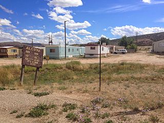
Alcova is a census-designated place (CDP) in Natrona County, Wyoming, United States. It is part of the Casper, Wyoming Metropolitan Statistical Area. The population was 34 at the 2020 census. Wyoming's center of population is located in the small Town of Alcova. Alcova and the nearby reservoir, Alcova Lake, are popular vacation spots with many seasonal residents.
Bessemer Bend is a census-designated place (CDP) in Natrona County, Wyoming, United States. It is part of the Casper, Wyoming Metropolitan Statistical Area. The population was 199 at the 2010 census.
Hartrandt is a census-designated place (CDP) in Natrona County, Wyoming, United States. It is part of the Casper, Wyoming Metropolitan Statistical Area and the population was 693 at the 2010 census.
Bondurant is a census-designated place (CDP) in Sublette County, Wyoming, United States. The population was 93 at the 2010 census. The town was named after B. F. Bondurant.
Calpet is an unincorporated community in Sublette County, Wyoming, United States. The population was 7 at the 2000 census, when it was a census-designated place (CDP).
Cora is a census-designated place (CDP) in Sublette County, Wyoming. The population was 114 at the 2020 census.
Daniel is a census-designated place in Sublette County, Wyoming, United States. The population was 150 at the 2010 census.
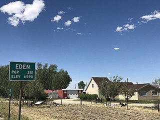
Eden is a census-designated place (CDP) in Sweetwater County, Wyoming, United States. The population was 281 at the 2010 census.
Farson is a census-designated place (CDP) in Sweetwater County, Wyoming, United States. The population was 313 at the 2010 census.
Moose Wilson Road is a census-designated place (CDP) in Teton County, Wyoming, United States. The population was 1,821 at the 2010 census. It is part of the Jackson, WY–ID Micropolitan Statistical Area.
South Park is a census-designated place (CDP) in Teton County, Wyoming, United States. The population was 1,831 at the 2010 census. It is part of the Jackson, WY–ID Micropolitan Statistical Area. The community does not have any connections with South Park, the animated Comedy Central television series.