Big Horn County, Wyoming

Last updated

Big Horn County
Big Horn County Courthouse, Wyoming.jpg
Big Horn County Courthouse
Flag of Big Horn County, Wyoming.gif
Map of Wyoming highlighting Big Horn County.svg
Location within the U.S. state of Wyoming
Wyoming in United States.svg
Wyoming's location within the U.S.
Coordinates: 44°32′N107°59′W / 44.53°N 107.99°W / 44.53; -107.99
CountryFlag of the United States.svg United States
StateFlag of Wyoming.svg  Wyoming
FoundedMarch 12, 1890 (authorized)
1897 (organized)
Named for Bighorn Mountains
Seat Basin
Largest town Lovell
Area
  Total3,159 sq mi (8,180 km2)
  Land3,137 sq mi (8,120 km2)
  Water22 sq mi (60 km2)  0.7%
Population
 (2020)
  Total11,521
  Density3.6/sq mi (1.4/km2)
Time zone UTC−7 (Mountain)
  Summer (DST) UTC−6 (MDT)
Congressional district At-large
Website www.bighorncountywy.gov

Big Horn County is a county in the U.S. state of Wyoming. As of the 2020 United States Census, the population was 11,521. [1] The county seat is Basin. [2] Its north boundary abuts the south boundary of Montana.

Contents

History

Big Horn County was created by the legislature of Wyoming Territory in March 1890, and was organized in 1897; its area was annexed from Fremont, Johnson, and Sheridan counties. [3] Big Horn County was named for the Big Horn Mountains which form its eastern boundary. [4] Originally, the county included the entire Big Horn Basin, but in 1909 Park County, WY was created from a portion of Big Horn County, and in 1911 Hot Springs and Washakie counties were created from portions of Big Horn, leaving the county with its present borders. There were large amounts of first generation immigrants from England and Germany living in Big Horn County when World War I broke out in Europe.

The two groups went out of their way to maintain cordial relations with one another, and the county did not see the sorts of anti-German sentiment that was common throughout much of the country. While the English residents were outspokenly pro-British, and many of their Wyoming-born sons went to Canada and joined the Canadian Armed Forces in order to serve in the war on England's side, they nonetheless made sure that their German co-workers and neighbors were not harassed or discriminated against. In late 1917 one English rancher referred to the effort as making sure that his German neighbor was always "treated like a gentleman." Another English rancher said that two of his ranch hands were from Germany and he "would hate to see the foolishness of national hatreds inflicted on men as decent as they are." English residents of Big Horn County went out of their way to make sure that German-born residents did not feel unwelcome. German immigrants and their Wyoming-born children were not "anti-British" though they favored America remaining neutral in the conflict. Before the war the most commonly read works of fiction among German-born residents of Big Horn County were German language translations of British adventure stories including The Four Feathers by A. E. W. Mason as well as Sherlock Holmes stories and The Light That Failed by Rudyard Kipling. Consensus among Big Horn County residents of all backgrounds after the war was that the war had ultimately been a tragedy and a "horrible waste of human life." [5]

Geography

According to the US Census Bureau, the county has a total area of 3,159 square miles (8,180 km2), of which 3,137 square miles (8,120 km2) is land and 22 square miles (57 km2) (0.7%) is water. [6]

Adjacent counties

Big Horn County in Wyoming and Montana are one of ten pairs of counties and parishes in the United States with the same name to border each other across state lines. The others are Sabine (Texas and Louisiana), Union (Arkansas and Louisiana), Bristol (Massachusetts and Rhode Island), Kent (Maryland and Delaware), Escambia (Alabama and Florida), Pike (Illinois and Missouri), Teton (Idaho and Wyoming), Park (Montana and Wyoming), and San Juan (New Mexico and Utah - albeit through a single point, the four corners).

Major highways

Transit

National protected areas

Demographics

Historical population
CensusPop.Note
1900 4,328
1910 8,886105.3%
1920 12,10536.2%
1930 11,222−7.3%
1940 12,91115.1%
1950 13,1762.1%
1960 11,898−9.7%
1970 10,202−14.3%
1980 11,89616.6%
1990 10,525−11.5%
2000 11,4618.9%
2010 11,6681.8%
2020 11,521−1.3%
2023 (est.)12,018 [7] 4.3%
US Decennial Census [8]
1870–2000 [9] 2010–2016 [1]

2000 census

As of the 2000 United States Census, [10] there were 11,461 people, 4,312 households, and 3,087 families in the county. The population density was 4 people per square mile (1.5 people/km2). There were 5,105 housing units at an average density of 2 units per square mile (0.77 units/km2). The racial makeup of the county was 94.03% White, 0.11% Black or African American, 0.75% Native American, 0.21% Asian, 0.07% Pacific Islander, 3.37% from other races, and 1.46% from two or more races. 6.17% of the population were Hispanic or Latino of any race. 23.0% were of German, 21.4% English, 8.1% American and 8.0% Irish ancestry.

There were 4,312 households, out of which 32.50% had children under the age of 18 living with them, 61.00% were married couples living together, 6.80% had a female householder with no husband present, and 28.40% were non-families. 25.00% of all households were made up of individuals, and 11.90% had someone living alone who was 65 years of age or older. The average household size was 2.60 and the average family size was 3.13.

The county population contained 28.70% under the age of 18, 7.30% from 18 to 24, 22.60% from 25 to 44, 24.60% from 45 to 64, and 16.80% who were 65 years of age or older. The median age was 39 years. For every 100 females there were 100.20 males. For every 100 females age 18 and over, there were 97.10 males.

The median income for a household in the county was $32,682, and the median income for a family was $38,237. Males had a median income of $30,843 versus $19,489 for females. The per capita income for the county was $15,086. About 10.20% of families and 14.10% of the population were below the poverty line, including 19.20% of those under age 18 and 10.00% of those age 65 or over.

2010 census

As of the 2010 United States Census, there were 11,668 people, 4,561 households, and 3,179 families in the county. [11] The population density was 3.7 people per square mile (1.4 people/km2). There were 5,379 housing units at an average density of 1.7 units per square mile (0.66 units/km2). [12] The racial makeup of the county was 94.4% white, 0.9% American Indian, 0.3% Asian, 0.2% black or African American, 3.0% from other races, and 1.2% from two or more races. Those of Hispanic or Latino origin made up 8.4% of the population. [11] In terms of ancestry, 30.0% were German, 22.3% were English, 10.4% were Irish, 7.6% were Scottish, and 5.7% were American. [13]

Of the 4,561 households, 31.0% had children under the age of 18 living with them, 58.2% were married couples living together, 7.6% had a female householder with no husband present, 30.3% were non-families, and 26.2% of all households were made up of individuals. The average household size was 2.52 and the average family size was 3.05. The median age was 41.8 years. [11]

The median income for a household in the county was $48,270 and the median income for a family was $57,705. Males had a median income of $40,762 versus $31,440 for females. The per capita income for the county was $24,486. About 5.7% of families and 8.9% of the population were below the poverty line, including 11.2% of those under age 18 and 7.1% of those age 65 or over. [14]

Government and infrastructure

The Wyoming Department of Health Wyoming Retirement Center, a nursing home, [15] is located in Basin. [16] [17] The facility was operated by the Wyoming Board of Charities and Reform until that agency was dissolved as a result of a state constitutional amendment passed in November 1990. [18]

Big Horn County voters have been reliably Republican for decades. They have selected the Republican Party candidate in every national election except one since 1936 (as of 2020).

United States presidential election results for Big Horn County, Wyoming [19]
Year Republican Democratic Third party
No.%No.%No.%
2020 4,80683.55%78813.70%1582.75%
2016 4,06776.49%60411.36%64612.15%
2012 4,28580.48%86816.30%1713.21%
2008 4,04576.18%1,10820.87%1572.96%
2004 4,23280.11%96018.17%911.72%
2000 3,72075.64%1,00420.41%1943.94%
1996 2,82158.30%1,43829.72%58011.99%
1992 2,21646.54%1,21625.54%1,33027.93%
1988 3,25868.16%1,46930.73%531.11%
1984 4,01976.51%1,17522.37%591.12%
1980 3,70971.01%1,21223.21%3025.78%
1976 3,11765.66%1,61834.08%120.25%
1972 3,24475.44%1,04924.40%70.16%
1968 2,77164.07%1,20127.77%3538.16%
1964 2,66849.79%2,69050.21%00.00%
1960 3,44962.79%2,04437.21%00.00%
1956 3,36965.01%1,81334.99%00.00%
1952 3,85968.67%1,75531.23%60.11%
1948 2,42950.36%2,37049.14%240.50%
1944 2,65953.47%2,31446.53%00.00%
1940 2,85952.22%2,59447.38%220.40%
1936 1,99638.12%3,15660.28%841.60%
1932 2,33451.15%2,15547.23%741.62%
1928 2,64673.58%93325.95%170.47%
1924 2,02354.45%45912.36%1,23333.19%
1920 2,15765.80%1,08233.01%391.19%
1916 1,23944.75%1,49353.92%371.34%
1912 79435.43%69130.83%75633.73%
1908 2,63860.28%1,64837.66%902.06%
1904 1,96270.83%75127.11%572.06%
1900 84363.77%47936.23%00.00%
1896 53846.95%59151.57%171.48%

Education

Big Horn County has four public school districts, Big Horn County School Districts 1-4: [20]

Communities

Towns

Census-designated places

Unincorporated communities

See also

Related Research Articles

<span class="mw-page-title-main">Johnson County, Wyoming</span> County in Wyoming, United States

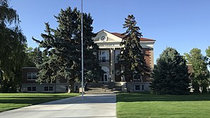
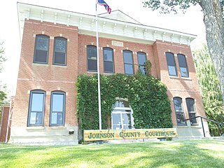
Johnson County is a county in the north central part of the U.S. state of Wyoming. At the 2020 United States Census, the population was 8,447. The county seat is Buffalo. Kaycee is the only other incorporated town in the county.

<span class="mw-page-title-main">Weston County, Wyoming</span> County in Wyoming, United States

Weston County is a county in the U.S. state of Wyoming. As of the 2020 United States Census, the population was 6,838. Its county seat is Newcastle. Its east boundary line abuts the west line of the state of South Dakota.

<span class="mw-page-title-main">Washakie County, Wyoming</span> County in Wyoming, United States

Washakie County is a county in the U.S. state of Wyoming. As of the 2020 United States Census, the population was 7,685. Its county seat is Worland.

<span class="mw-page-title-main">Teton County, Wyoming</span> County in Wyoming, United States

Teton County is a county in the U.S. state of Wyoming. As of the 2020 United States Census, the population was 23,331. Its county seat is Jackson. Its west boundary line is also the Wyoming state boundary shared with Idaho and the southern tip of Montana. Teton County is part of the Jackson, WY-ID Micropolitan Statistical Area.

<span class="mw-page-title-main">Sweetwater County, Wyoming</span> County in Wyoming, United States

Sweetwater County is a county in southwestern Wyoming, United States. As of the 2020 United States Census, the population was 42,272, making it the fourth-most populous county in Wyoming. Its county seat is Green River. By area, it is the largest county in Wyoming. Its southern boundary line abuts the north lines of the states of Colorado and Utah.

<span class="mw-page-title-main">Sheridan County, Wyoming</span> County in Wyoming, United States

Sheridan County is a county in the U.S. state of Wyoming. As of the 2020 United States Census, the population was 30,921. The county seat is Sheridan. Its northern boundary abuts the Montana state border.

<span class="mw-page-title-main">Park County, Wyoming</span> County in Wyoming, United States

Park County is a county in the U.S. state of Wyoming. As of the 2020 United States Census, the population was 29,624. The county seat is Cody.

<span class="mw-page-title-main">Natrona County, Wyoming</span> County in Wyoming, United States

Natrona County is a county in the U.S. state of Wyoming. As of the 2020 United States Census, the population was 79,955, making it the second-most populous county in Wyoming. Its county seat is Casper.

<span class="mw-page-title-main">Hot Springs County, Wyoming</span> County in Wyoming, United States

Hot Springs County is a county in the U.S. state of Wyoming. As of the 2020 United States Census, the population was 4,696, making it the second-least populous county in Wyoming. Its county seat is Thermopolis. The county is named for the hot springs located in Hot Springs State Park.

<span class="mw-page-title-main">Fremont County, Wyoming</span> County in Wyoming, United States

Fremont County is a county in the U.S. state of Wyoming. As of the 2020 United States census, the population was 39,234, making it the fifth-most populous county in Wyoming. Its county seat is Lander. The county was founded in 1884 and is named for John C. Frémont, a general, explorer, and politician. It is roughly the size of the state of Vermont.

<span class="mw-page-title-main">Crook County, Wyoming</span> County in Wyoming, United States

Crook County is a county in the northeastern corner of the U.S. state of Wyoming. As of the 2020 United States Census, the population was 7,181, making it the third-least populous county in Wyoming. Its county seat and largest city is Sundance. The county is located at the northwestern extreme of the Black Hills, which are its defining geographical feature.

<span class="mw-page-title-main">Converse County, Wyoming</span> County in Wyoming, United States

Converse County is a county located in the U.S. state of Wyoming. As of the 2020 United States Census, the population was 13,751. Its county seat is Douglas.

<span class="mw-page-title-main">Campbell County, Wyoming</span> County in Wyoming, United States

Campbell County is a county in the U.S. state of Wyoming. As of the 2020 United States Census, the population was 47,026, making it the third-most populous county in Wyoming. Its county seat is Gillette.

<span class="mw-page-title-main">Albany County, Wyoming</span> County in Wyoming, United States

Albany County is a county in the U.S. state of Wyoming. As of the 2020 United States Census, the population was 37,066. Its county seat is Laramie, the site of the University of Wyoming. Its south border lies on the northern Colorado state line.

<span class="mw-page-title-main">Powder River County, Montana</span> County in Montana, United States

Powder River County is a county in the U.S. state of Montana. As of the 2020 census, the population was 1,694. Its county seat is Broadus.

<span class="mw-page-title-main">Gallatin County, Montana</span> County in Montana, United States

Gallatin County is located in the U.S. state of Montana. With its county seat in Bozeman, it is the second-most populous county in Montana, with a population of 118,960 in the 2020 Census.

<span class="mw-page-title-main">Carbon County, Montana</span> County in Montana, United States

Carbon County is a county located in the U.S. state of Montana. As of the 2020 census, the population was 10,473. Its county seat is Red Lodge.

<span class="mw-page-title-main">Big Horn County, Montana</span> County in Montana, United States

Big Horn County is a county located in the U.S. state of Montana. As of the 2020 census, the population was 13,124. The county seat is Hardin. The county, like the river and the mountain range, is named after the bighorn sheep in the Rocky Mountains. The county was founded in 1913. It is located on the south line of the state.

<span class="mw-page-title-main">Basin, Wyoming</span> Town in Wyoming, United States

Basin is a town in, and the county seat of, Big Horn County, Wyoming, United States. The population was 1,225 at the 2020 census. The community is located near the center of the Bighorn Basin with the Big Horn River east of the town. Basin's post office, built in 1919, is listed on the National Register of Historic Places.

<span class="mw-page-title-main">Worland, Wyoming</span> City in Wyoming, United States

Worland is a city in Washakie County, Wyoming, United States. The population was 5,487 at the 2010 census. It is the county seat of Washakie County. It is located within the Big Horn Basin and along the Big Horn River in northwestern Wyoming.

References

  1. 1 2 "State & County QuickFacts". US Census Bureau. Archived from the original on February 29, 2016. Retrieved January 25, 2014.
  2. "Find a County". National Association of Counties. Archived from the original on May 31, 2011. Retrieved June 7, 2011.
  3. Long, John H., ed. (2004). "Wyoming: Individual County Chronologies". Wyoming Atlas of Historical County Boundaries. The Newberry Library. Archived from the original on August 3, 2015. Retrieved August 19, 2015.
  4. Urbanek, Mae (1988). Wyoming Place Names. Missoula MT: Mountain Press Pub. Co. ISBN   0-87842-204-8.
  5. Wyoming in World War I by Dale A. Poeske · 1968, pg. 14-16
  6. "2010 Census Gazetteer Files". US Census Bureau. August 22, 2012. Retrieved August 5, 2015.
  7. "Annual Estimates of the Resident Population for Counties: April 1, 2020 to July 1, 2023". United States Census Bureau. Retrieved March 24, 2024.
  8. "US Decennial Census". US Census Bureau. Retrieved August 5, 2015.
  9. "Historical Decennial Census Population for Wyoming Counties, Cities, and Towns". Wyoming Department of Administration & Information, Division of Economic Analysis. Retrieved January 25, 2014.
  10. "U.S. Census website". US Census Bureau. Retrieved May 14, 2011.
  11. 1 2 3 "Profile of General Population and Housing Characteristics: 2010 Demographic Profile Data". US Census Bureau. Archived from the original on February 13, 2020. Retrieved January 12, 2016.
  12. "Population, Housing Units, Area, and Density: 2010 - County". US Census Bureau. Archived from the original on February 13, 2020. Retrieved January 12, 2016.
  13. "Selected Social Characteristics in the US – 2006-2010 American Community Survey 5-Year Estimates". US Census Bureau. Archived from the original on February 13, 2020. Retrieved January 12, 2016.
  14. "Selected Economic Characteristics – 2006-2010 American Community Survey 5-Year Estimates". US Census Bureau. Archived from the original on February 13, 2020. Retrieved January 12, 2016.
  15. WDH Who We Are - Wyoming Retirement Center Archived June 27, 2007, at the Wayback Machine Wyoming Department of Health. Retrieved on December 12, 2010.
  16. WDH Directory [ permanent dead link ]. Wyoming Department of Health. Retrieved on December 12, 2010. "890 Highway 20, Basin WY 82410 Fax (307) 568-3887" (Retirement Center)
  17. Basin town, Wyoming [ permanent dead link ]. US Census Bureau. Retrieved on December 12, 2010.
  18. About the Department of Corrections. Wyoming Department of Corrections. Retrieved on August 22, 2010.
  19. Leip, David. "Atlas of US Presidential Elections". uselectionatlas.org. Retrieved May 5, 2018.
  20. Wyoming Department of Education School Calendar 2007-2008 Archived February 11, 2008, at the Wayback Machine , retrieved May 8, 2008
  21. Kane WY Google Maps (accessed 9 January 2019)
  22. Reeves Corner WY Google Maps (accessed 9 January 2019)

44°32′N107°59′W / 44.53°N 107.99°W / 44.53; -107.99