Laramie County, Wyoming

Last updated

Laramie County
CheyenneWY POAndCourthouse.jpg
United States Post Office and Courthouse, Cheyenne, Wyoming
Flag of Laramie County, Wyoming.gif
Map of Wyoming highlighting Laramie County.svg
Location within the U.S. state of Wyoming
Wyoming in United States.svg
Wyoming's location within the U.S.
Coordinates: 41°19′N104°41′W / 41.32°N 104.69°W / 41.32; -104.69
CountryFlag of the United States.svg United States
StateFlag of Wyoming.svg  Wyoming
FoundedJanuary 9, 1867
Named for Jacques La Ramee
Seat Cheyenne
Largest cityCheyenne
Area
  Total2,688 sq mi (6,960 km2)
  Land2,686 sq mi (6,960 km2)
  Water1.6 sq mi (4 km2)  0.06%
Population
 (2020)
  Total100,512
  Density37.39/sq mi (14.44/km2)
Time zone UTC−7 (Mountain)
  Summer (DST) UTC−6 (MDT)
Congressional district At-large
Website laramiecounty.com

Laramie County is a county located at the southeast corner of the state of Wyoming. As of the 2020 United States Census, the population was 100,512 or 17.4% of the state's total 2020 population, [1] making it the most populous county in Wyoming, but the least populous county in the United States to be the most populous in its state.

Contents

The county seat is Cheyenne, the state capital. [2] The county lies west of the Nebraska state line and north of the Colorado state line.

Laramie County comprises the Cheyenne, WY Metropolitan Statistical Area.

The city of Laramie, Wyoming, is in neighboring Albany County.

History

Laramie County was originally created in 1867 as a county within the Dakota Territory. [3] The county was named for Jacques La Ramee, a French-Canadian fur-trader. [4] In 1867, a portion of Laramie County was annexed to create Sweetwater County; in 1868; further annexations occurred to create Albany County and Carbon County. Laramie County became a county in the Wyoming Territory when the territorial government was formed in 1869. Crook County was created with land ceded by Laramie County in 1875. In 1888, Converse County was formed from a portion of Laramie County. In 1911, Goshen and Platte Counties were formed from parts of Laramie County, giving the county its current boundaries.

The county's early economy was based on agriculture and livestock raising. The present-day Wyoming Stock Growers Association [5] dates from that era. Other types of animal husbandry also occurred. [6]

Some of the settlers in early Laramie County were foreign immigrants; for example, Burns was largely settled by German immigrants. [6]

Arts and culture

Laramie County Library System

The Laramie County Library System is one of the oldest continually operating county library systems in the United States, [7] the first branch established in Cheyenne in 1886. [8] In 1899, Andrew Carnegie donated $50,000 toward the building of the state's first Carnegie Public Library, which opened in 1902. [7] The library moved to a larger location in 1969. [8] In 2007, a second library opened. [7]

Geography

According to the U.S. Census Bureau, the county has a total area of 2,688 square miles (6,960 km2), of which 2,686 square miles (6,960 km2) is land and 1.6 square miles (4.1 km2) (0.06%) is water. [9]

Adjacent counties

Major highways

Transit

Demographics

Historical population
CensusPop.Note
1870 2,957
1880 6,409116.7%
1890 16,777161.8%
1900 20,18120.3%
1910 26,12729.5%
1920 20,699−20.8%
1930 26,84529.7%
1940 33,65125.4%
1950 47,66241.6%
1960 60,14926.2%
1970 56,360−6.3%
1980 68,64921.8%
1990 73,1426.5%
2000 81,60711.6%
2010 91,73812.4%
2020 100,5129.6%
2023 (est.)100,984 [10] 0.5%
US Decennial Census [11]
1870–2000 [12] 2010–2020 [13]

2000 census

As of the 2000 United States Census, Laramie County had 81,607 people, 31,927 households, and 21,614 families. [14] The population density was 30 people per square mile (12 people/km2). The county had 34,213 housing units at an average density of 13 units per square mile (5.0 units/km2). The racial makeup of the county was 88.92% White, 2.60% Black or African American, 0.85% Native American, 0.95% Asian, 0.11% Pacific Islander, 4.00% from other races, and 2.57% from two or more races. 10.90% of the population were Hispanic or Latino of any race. 23.7% were of German, 11.1% English, 10.3% Irish and 7.4% American ancestry.

As of the 2000 census, Laramie County had 31,927 households, of which 33.20% had children under the age of 18 living with them, 53.90% were married couples living together, 9.90% had a female householder with no husband present, and 32.30% were non-families. 27.20% of all households were made up of a single individual and 8.90% had someone living alone who was 65 years of age or older. The average household size was 2.45 and the average family size was 2.98.

The county population contained 25.80% under the age of 18, 9.60% from 18 to 24, 30.50% from 25 to 44, 22.70% from 45 to 64, and 11.50% who were 65 years of age or older. The median age was 35 years. For every 100 females, the county had 100-100.9 males.

The median income for a household in the county was $39,607, and the median income for a family was $46,536. Males had a median income of $31,644 versus $24,406 for females. The per capita income for the county was $19,634. About 6.50% of families and 9.10% of the population were below the poverty line, including 12.00% of those under age 18 and 6.50% of those age 65 or over.

2010 census

As of the 2010 United States Census, there were 91,738 people, 37,576 households, and 24,340 families in the county. [15] The population density was 34.2 people per square mile (13.2 people/km2). There were 40,462 housing units at an average density of 15.1 units per square mile (5.8 units/km2). [16] The racial makeup of the county was 88.5% white, 2.5% black or African American, 1.1% Asian, 1.0% American Indian, 0.2% Pacific islander, 3.8% from other races, and 3.1% from two or more races. Those of Hispanic or Latino origin made up 13.1% of the population. [15] In terms of ancestry, 29.5% were German, 15.5% were Irish, 12.7% were English, and 4.9% were American. [17]

Of the 37,576 households, 31.9% had children under the age of 18 living with them, 49.3% were married couples living together, 10.7% had a female householder with no husband present, 35.2% were non-families, and 29.1% of all households were made up of individuals. The average household size was 2.40 and the average family size was 2.95. The median age was 37.0 years. [15]

The median income for a household in the county was $52,824 and the median income for a family was $64,589. Males had a median income of $44,001 versus $32,882 for females. The per capita income for the county was $27,406. About 6.7% of families and 9.6% of the population were below the poverty line, including 13.8% of those under age 18 and 4.0% of those age 65 or over. [18]

Communities

City

Towns

Census-designated places

Unincorporated communities

Politics and government

Like Wyoming as a whole, Laramie County is strongly Republican. It is extremely conservative for an urban county, having not backed the Democratic presidential candidate since Lyndon Johnson in 1964–one of only two times since 1952 that it has supported a Democrat. In 2016, Hillary Clinton managed to win just 28.3 percent of the vote in the county, the lowest total of any presidential candidate in Laramie since John W. Davis in 1924, when a large proportion of liberal voters defected to Robert M. La Follette, Sr. [21] Nonetheless, the county is the third-friendliest to Democrats in the state, beaten only by Teton County and Albany County.

United States presidential election results for Laramie County, Wyoming [21]
Year Republican Democratic Third party
No.%No.%No.%
2020 27,89162.00%15,21733.83%1,8744.17%
2016 24,84760.65%11,57328.25%4,54911.10%
2012 23,90460.51%14,29536.19%1,3063.31%
2008 24,54958.98%16,07238.61%1,0042.41%
2004 25,95165.07%13,17133.03%7571.90%
2000 21,79761.71%12,16234.43%1,3643.86%
1996 16,92449.97%13,67640.38%3,2699.65%
1992 12,89040.46%12,17738.23%6,78821.31%
1988 15,56156.04%11,85142.68%3581.29%
1984 19,34864.93%10,11033.93%3411.14%
1980 15,36155.43%9,51234.32%2,84010.25%
1976 14,06153.48%12,04045.79%1930.73%
1972 15,01065.67%7,79134.09%540.24%
1968 9,82446.80%9,51945.35%1,6497.86%
1964 8,56334.78%16,05965.22%00.00%
1960 11,63749.05%12,08650.95%00.00%
1956 10,58153.84%9,07246.16%00.00%
1952 10,78556.61%8,18742.97%790.41%
1948 6,20042.69%8,22656.64%980.67%
1944 7,32649.27%7,54250.73%00.00%
1940 5,95543.09%7,80856.50%570.41%
1936 4,35635.88%7,59462.55%1901.57%
1932 5,11646.77%5,43549.69%3873.54%
1928 5,86265.33%3,02933.76%820.91%
1924 3,94453.00%1,12015.05%2,37831.95%
1920 3,39962.60%1,81033.33%2214.07%
1916 2,42845.64%2,75951.86%1332.50%
1912 1,87138.95%1,92340.03%1,01021.02%
1908 2,96552.65%2,52344.80%1442.56%
1904 3,10969.77%1,16726.19%1804.04%
1900 2,18158.64%1,53841.36%00.00%
1896 1,77651.88%1,62847.56%190.56%
1892 1,89057.48%00.00%1,39842.52%

Education

There are two school districts in Laramie County: Laramie County School District 1 and Laramie County School District 2. [22]

See also

Related Research Articles

<span class="mw-page-title-main">Johnson County, Wyoming</span> County in Wyoming, United States

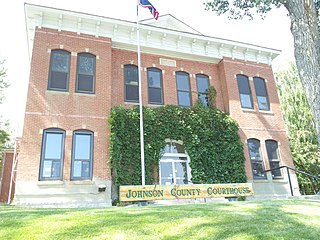
Johnson County is a county in the north central part of the U.S. state of Wyoming. At the 2020 United States Census, the population was 8,447. The county seat is Buffalo. Kaycee is the only other incorporated town in the county.

<span class="mw-page-title-main">Sweetwater County, Wyoming</span> County in Wyoming, United States

Sweetwater County is a county in southwestern Wyoming, United States. As of the 2020 United States Census, the population was 42,272, making it the fourth-most populous county in Wyoming. Its county seat is Green River. By area, it is the largest county in Wyoming. Its southern boundary line abuts the north lines of the states of Colorado and Utah.

<span class="mw-page-title-main">Sheridan County, Wyoming</span> County in Wyoming, United States

Sheridan County is a county in the U.S. state of Wyoming. As of the 2020 United States Census, the population was 30,921. The county seat is Sheridan. Its northern boundary abuts the Montana state border.

<span class="mw-page-title-main">Platte County, Wyoming</span> County in Wyoming, United States

Platte County is a county located in the U.S. state of Wyoming. As of the 2020 United States Census, the population was 8,605. Its county seat is Wheatland.

<span class="mw-page-title-main">Park County, Wyoming</span> County in Wyoming, United States

Park County is a county in the U.S. state of Wyoming. As of the 2020 United States Census, the population was 29,624. The county seat is Cody.

<span class="mw-page-title-main">Natrona County, Wyoming</span> County in Wyoming, United States

Natrona County is a county in the U.S. state of Wyoming. As of the 2020 United States Census, the population was 79,955, making it the second-most populous county in Wyoming. Its county seat is Casper.

<span class="mw-page-title-main">Goshen County, Wyoming</span> County in Wyoming, United States

Goshen County is a county in the U.S. state of Wyoming. As of the 2020 United States Census, the population was 12,498. Its county seat is Torrington. The eastern boundary of the County borders the Nebraska state line.

<span class="mw-page-title-main">Fremont County, Wyoming</span> County in Wyoming, United States

Fremont County is a county in the U.S. state of Wyoming. As of the 2020 United States census, the population was 39,234, making it the fifth-most populous county in Wyoming. Its county seat is Lander. The county was founded in 1884 and is named for John C. Frémont, a general, explorer, and politician. It is roughly the size of the state of Vermont.

<span class="mw-page-title-main">Crook County, Wyoming</span> County in Wyoming, United States

Crook County is a county in the northeastern corner of the U.S. state of Wyoming. As of the 2020 United States Census, the population was 7,181, making it the third-least populous county in Wyoming. Its county seat and largest city is Sundance. The county is located at the northwestern extreme of the Black Hills, which are its defining geographical feature.

<span class="mw-page-title-main">Converse County, Wyoming</span> County in Wyoming, United States

Converse County is a county located in the U.S. state of Wyoming. As of the 2020 United States Census, the population was 13,751. Its county seat is Douglas.

<span class="mw-page-title-main">Carbon County, Wyoming</span> County in Wyoming, United States

Carbon County is a county in the U.S. state of Wyoming. As of the 2020 United States Census, the population was 14,537. Its county seat is Rawlins. Its south border abuts the north line of Colorado.

<span class="mw-page-title-main">Big Horn County, Wyoming</span> County in Wyoming, United States

Big Horn County is a county in the U.S. state of Wyoming. As of the 2020 United States Census, the population was 11,521. The county seat is Basin. Its north boundary abuts the south boundary of Montana.

<span class="mw-page-title-main">Albany County, Wyoming</span> County in Wyoming, United States

Albany County is a county in the U.S. state of Wyoming. As of the 2020 United States Census, the population was 37,066. Its county seat is Laramie, the site of the University of Wyoming. Its south border lies on the northern Colorado state line.

<span class="mw-page-title-main">Fort Laramie, Wyoming</span> Town in Wyoming, United States

Fort Laramie is a town in Goshen County, Wyoming, United States. The population was 206 at the 2020 census. The town is named after historic Fort Laramie, an important stop on the Oregon, California and Mormon trails, as well as a staging point for various military excursions and treaty signings. The old fort was located south of town across the North Platte River, at the mouth of the Laramie River.

<span class="mw-page-title-main">Torrington, Wyoming</span> City in Wyoming, United States

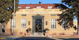
Torrington is a city in, and the county seat of, Goshen County, Wyoming, United States. The population was 6,501 at the 2010 census.

<span class="mw-page-title-main">Albin, Wyoming</span> Town in Laramie County, Wyoming, United States

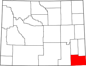
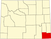
Albin is a town in Laramie County, Wyoming, United States. It is part of the Cheyenne Metropolitan Statistical Area. The population was 169 at the 2020 census.

<span class="mw-page-title-main">Burns, Wyoming</span> Town in Laramie County, Wyoming, United States

Burns is a town in Laramie County, Wyoming, United States. It is part of the Cheyenne, Wyoming Metropolitan Statistical Area. The population was 301 at the 2010 census.

<span class="mw-page-title-main">Fox Farm-College, Wyoming</span> Census-designated place in Wyoming, United States

Fox Farm-College is a census-designated place (CDP) in Laramie County, Wyoming, United States. It is part of the Cheyenne, Wyoming Metropolitan Statistical Area. The population was 3,876 people at the 2020 census.

<span class="mw-page-title-main">Pine Bluffs, Wyoming</span> Town in Wyoming, United States

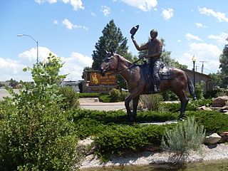
Pine Bluffs is a town in eastern Laramie County, Wyoming, United States. It is located on the county's border with Nebraska. Pine Bluffs is part of the Cheyenne, Wyoming, Metropolitan Statistical Area. The population was 1,129 at the 2010 census. It was first known as Rock Ranch, but the name was changed by railroad officials for the pines on the nearby bluffs.

<span class="mw-page-title-main">South Greeley, Wyoming</span> Census-designated place in Wyoming, United States

South Greeley is a census-designated place (CDP) in Laramie County, Wyoming, United States. It is part of the Cheyenne, Wyoming Metropolitan Statistical Area. The population was 4,733 at the 2020 census. The population was 4,217 at the 2010 census.

References

  1. "State & County QuickFacts".
  2. "Find a County". National Association of Counties. Retrieved June 7, 2011.
  3. Long, John H. (2006). "Wyoming: Individual County Chronologies". Wyoming Atlas of Historical County Boundaries. The Newberry Library. Archived from the original on July 18, 2011. Retrieved September 1, 2011.
  4. Urbanek, Mae (1988). Wyoming Place Names. Missoula MT: Mountain Press Pub. Co. ISBN   0-87842-204-8.
  5. Osgood, Ernest Staples. The Day of the Cattleman. Chicago: University of Chicago Press, 1929. Print. pp. 120-121
  6. 1 2 Herman, Marguerite. "Laramie County WY". Wyoming State Historical Society. Retrieved April 17, 2014.
  7. 1 2 3 "Laramie County Library". Laramie County Library System. Retrieved October 27, 2021.
  8. 1 2 "Laramie County Library". Laramie County Library System. Retrieved November 29, 2021.
  9. "2010 Census Gazetteer Files". US Census Bureau. August 22, 2012. Retrieved August 18, 2015.
  10. "Annual Estimates of the Resident Population for Counties: April 1, 2020 to July 1, 2023". United States Census Bureau. Retrieved March 24, 2024.
  11. "US Decennial Census". US Census Bureau. Retrieved August 18, 2015.
  12. "Historical Decennial Census Population for Wyoming Counties, Cities, and Towns". Wyoming Department of Administration & Information, Division of Economic Analysis. Retrieved January 25, 2014.
  13. "State & County QuickFacts". US Census Bureau. Archived from the original on July 3, 2011. Retrieved January 25, 2014.
  14. "U.S. Census website". US Census Bureau. Retrieved May 14, 2011.
  15. 1 2 3 "Profile of General Population and Housing Characteristics: 2010 Demographic Profile Data". US Census Bureau. Archived from the original on February 13, 2020. Retrieved January 12, 2016.
  16. "Population, Housing Units, Area, and Density: 2010 - County". US Census Bureau. Archived from the original on February 13, 2020. Retrieved January 12, 2016.
  17. "Selected Social Characteristics in the US – 2006-2010 American Community Survey 5-Year Estimates". US Census Bureau. Archived from the original on February 13, 2020. Retrieved January 12, 2016.
  18. "Selected Economic Characteristics – 2006-2010 American Community Survey 5-Year Estimates". US Census Bureau. Archived from the original on February 13, 2020. Retrieved January 12, 2016.
  19. Altvan WY Google Maps (accessed January 10, 2019)
  20. Egbert WY Google Maps (accessed January 10, 2019)
  21. 1 2 Leip, David. "Atlas of US Presidential Elections". uselectionatlas.org. Retrieved April 5, 2018.
  22. "2020 CENSUS - SCHOOL DISTRICT REFERENCE MAP: Laramie County, WY" (PDF). U.S. Census Bureau . Retrieved March 13, 2024. - Text list

Further reading

Commons-logo.svg Media related to Laramie County, Wyoming at Wikimedia Commons

41°19′N104°41′W / 41.32°N 104.69°W / 41.32; -104.69