South Greeley, Wyoming

Last updated

South Greeley
South Greeley, Wyoming.JPG
Looking west from the Intersection of South Greeley Highway (U.S. Route 85) and College Drive in South Greeley.
Laramie County Wyoming incorporated and unincorporated areas South Greeley highlighted.svg
Location in Laramie County and the state of Wyoming.
Usa edcp location map.svg
Red pog.svg
South Greeley
Location in the United States
Coordinates: 41°5′49″N104°48′19″W / 41.09694°N 104.80528°W / 41.09694; -104.80528
Country United States
State Wyoming
County Laramie
Area
  Total1.7 sq mi (4.4 km2)
  Land1.7 sq mi (4.4 km2)
  Water0.0 sq mi (0.0 km2)
Elevation
6,047 ft (1,843 m)
Population
 (2020)
  Total4,733
  Density2,800/sq mi (1,100/km2)
Time zone UTC-7 (Mountain (MST))
  Summer (DST) UTC-6 (MDT)
Area code 307
FIPS code 56-71800 [1]
GNIS feature ID1867671 [2]

South Greeley is a census-designated place (CDP) in Laramie County, Wyoming, United States. It is part of the Cheyenne, Wyoming Metropolitan Statistical Area. The population was 4,733 at the 2020 census. [3] The population was 4,217 at the 2010 census. [4]

Contents

Geography

South Greeley is located at 41°5′49″N104°48′19″W / 41.09694°N 104.80528°W / 41.09694; -104.80528 (41.097040, -104.805302). [5]

According to the United States Census Bureau, the CDP has a total area of 1.7 square miles (4.4 km2), all land.

Despite its name, South Greeley is not adjacent to any other municipality with Greeley in its name. The nearest such place, Greeley, Colorado, lies approximately 50 miles to the south of South Greeley.

Demographics

At the 2020 Census, there were 4,733 people. [3] At the 2000 census, [1] there were 4,201 people, 1,553 households and 1,091 families residing in the CDP. The population density was 2,489.6 per square mile (959.8/km2). There were 1,679 housing units at an average density of 995.0/sq mi (383.6/km2). The racial makeup of the CDP was 84.86% White, 2.31% African American, 1.50% Native American, 0.33% Asian, 7.19% from other races, and 3.81% from two or more races. Hispanic or Latino of any race were 14.90% of the population.

There were 1,553 households, of which 42.0% had children under the age of 18 living with them, 48.6% were married couples living together, 14.8% had a female householder with no husband present, and 29.7% were non-families. 22.5% of all households were made up of individuals, and 4.7% had someone living alone who was 65 years of age or older. The average household size was 2.71 and the average family size was 3.15.

32.1% of the population were under the age of 18, 10.9% from 18 to 24, 33.8% from 25 to 44, 17.8% from 45 to 64, and 5.3% who were 65 years of age or older. The median age was 29 years. For every 100 females, there were 103.3 males. For every 100 females age 18 and over, there were 101.2 males.

The median household income was $31,729 and the median family income was $34,015. Males had a median income of $28,468 vand females $19,696. The per capita income was $13,925. About 14.0% of families and 16.6% of the population were below the poverty line, including 23.4% of those under age 18 and 12.2% of those age 65 or over.

Education

Public education in the community of South Greeley is provided by Laramie County School District #1.

Related Research Articles

<span class="mw-page-title-main">Platte County, Wyoming</span> County in Wyoming, United States

Platte County is a county located in the U.S. state of Wyoming. As of the 2020 United States Census, the population was 8,605. Its county seat is Wheatland.

<span class="mw-page-title-main">Laramie County, Wyoming</span> County in Wyoming, United States

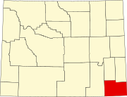
Laramie County is a county located at the southeast corner of the state of Wyoming. As of the 2020 United States Census, the population was 100,512 or 17.4% of the state's total 2020 population, making it the most populous county in Wyoming, but the least populous county in the United States to be the most populous in its state.

<span class="mw-page-title-main">Albany County, Wyoming</span> County in Wyoming, United States

Albany County is a county in the U.S. state of Wyoming. As of the 2020 United States Census, the population was 37,066. Its county seat is Laramie, the site of the University of Wyoming. Its south border lies on the northern Colorado state line.

<span class="mw-page-title-main">St. Paul, San Patricio County, Texas</span> Place in Texas, United States

St. Paul is a census-designated place (CDP) in San Patricio County, Texas, United States. The population was 584 at the 2010 census.

<span class="mw-page-title-main">Centennial, Wyoming</span> CDP in Wyoming, United States

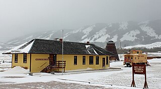
Centennial is a small mountain-town in Albany County, Wyoming, United States. It serves a fairly large surrounding landscape, along with a few ranches, located along a gently sloping hillside traversed by a highway. Because it has been, since 1980 or later, included in a census-designated place (CDP), bearing the town's name, specific demographics characterizing the town itself are not available.

<span class="mw-page-title-main">Esterbrook, Wyoming</span> CDP in Wyoming, United States

Esterbrook is a village, and the locus of a same-named census-designated place (CDP), in Converse County, Wyoming, United States in the Medicine Bow National Forest. The population was 52 at the 2010 census.

<span class="mw-page-title-main">Ethete, Wyoming</span> CDP in Wyoming, United States

Ethete is a census-designated place (CDP) in Fremont County, Wyoming, United States. The population was 1,553 at the 2010 census. The town is located on the Wind River Indian Reservation. It grew up around the Episcopal St. Michael's Mission.

<span class="mw-page-title-main">Fort Laramie, Wyoming</span> Town in Wyoming, United States

Fort Laramie is a town in Goshen County, Wyoming, United States. The population was 206 at the 2020 census. The town is named after historic Fort Laramie, an important stop on the Oregon, California and Mormon trails, as well as a staging point for various military excursions and treaty signings. The old fort was located south of town across the North Platte River, at the mouth of the Laramie River.

<span class="mw-page-title-main">Hawk Springs, Wyoming</span> CDP in Wyoming, United States

Hawk Springs is a census-designated place (CDP) in Goshen County, Wyoming, United States. The population was 45 at the 2010 census.

<span class="mw-page-title-main">Burns, Wyoming</span> Town in Laramie County, Wyoming, United States

Burns is a town in Laramie County, Wyoming, United States. It is part of the Cheyenne, Wyoming Metropolitan Statistical Area. The population was 301 at the 2010 census.

<span class="mw-page-title-main">Fox Farm-College, Wyoming</span> Census-designated place in Wyoming, United States

Fox Farm-College is a census-designated place (CDP) in Laramie County, Wyoming, United States. It is part of the Cheyenne, Wyoming Metropolitan Statistical Area. The population was 3,876 people at the 2020 census.

<span class="mw-page-title-main">Ranchettes, Wyoming</span> Census-designated place in Wyoming, United States

Ranchettes is a census-designated place (CDP) in Laramie County, Wyoming, United States. It is part of the Cheyenne, Wyoming Metropolitan Statistical Area. The population was 5,798 at the 2010 census.

Oakley is a census-designated place (CDP) in Lincoln County, Wyoming, United States. The population was 49 at the 2010 census.

Vista West is a census-designated place (CDP) in Natrona County, Wyoming, United States. It is part of the Casper, Wyoming Metropolitan Statistical Area. The population was 951 at the 2010 census.

<span class="mw-page-title-main">Chugcreek, Wyoming</span> CDP in Wyoming, United States

Chugcreek is a census-designated place (CDP) in Platte County, Wyoming, United States. The population was 156 at the 2010 census.

<span class="mw-page-title-main">Lakeview North, Wyoming</span> CDP in Wyoming, United States

Lakeview North is a census-designated place (CDP) in Platte County, Wyoming, United States. The population was 84 at the 2010 census.

<span class="mw-page-title-main">Slater, Wyoming</span> CDP in Wyoming, United States

Slater is a census-designated place (CDP) in Platte County, Wyoming, United States. The population was 80 at the 2010 census.

<span class="mw-page-title-main">Fort Bridger, Wyoming</span> Census-designated place in Uinta County, Wyoming, United States

Fort Bridger is a census-designated place (CDP) in eastern Uinta County, Wyoming, United States. The population was 345 at the 2010 census. The community takes its name from the eponymous Fort Bridger, established in 1842, which is located within the boundaries of the CDP.

West River is an unincorporated community in Washakie County, Wyoming, United States. The population was 321 at the 2000 census, when it was a census-designated place (CDP).

<span class="mw-page-title-main">Hill View Heights, Wyoming</span> CDP in Wyoming, United States

Hill View Heights is a census-designated place (CDP) in Weston County, Wyoming, United States. The population was 170 at the 2010 census.

References

  1. 1 2 "U.S. Census website". United States Census Bureau . Retrieved January 31, 2008.
  2. "US Board on Geographic Names". United States Geological Survey. October 25, 2007. Retrieved January 31, 2008.
  3. 1 2 "Population by Race and Hispanic Origin for Places". eadiv.state.wy.us. 2020. Archived from the original on August 16, 2022. Retrieved July 4, 2023.
  4. "Profile of General Population and Housing Characteristics: 2010 Demographic Profile Data (DP-1): South Greeley CDP, Wyoming". United States Census Bureau . Retrieved April 3, 2012.
  5. "US Gazetteer files: 2010, 2000, and 1990". United States Census Bureau. February 12, 2011. Retrieved April 23, 2011.